D08 Cody Yellowstone NP

This route was brought to you by:
RouteXpert Hans van de Ven (Mr.MRA)
Last edit: 02-05-2021
 Route Summary
 The roads are good and the views then wide and then frightening again, but always very beautiful, a long day with many stops to take pictures.
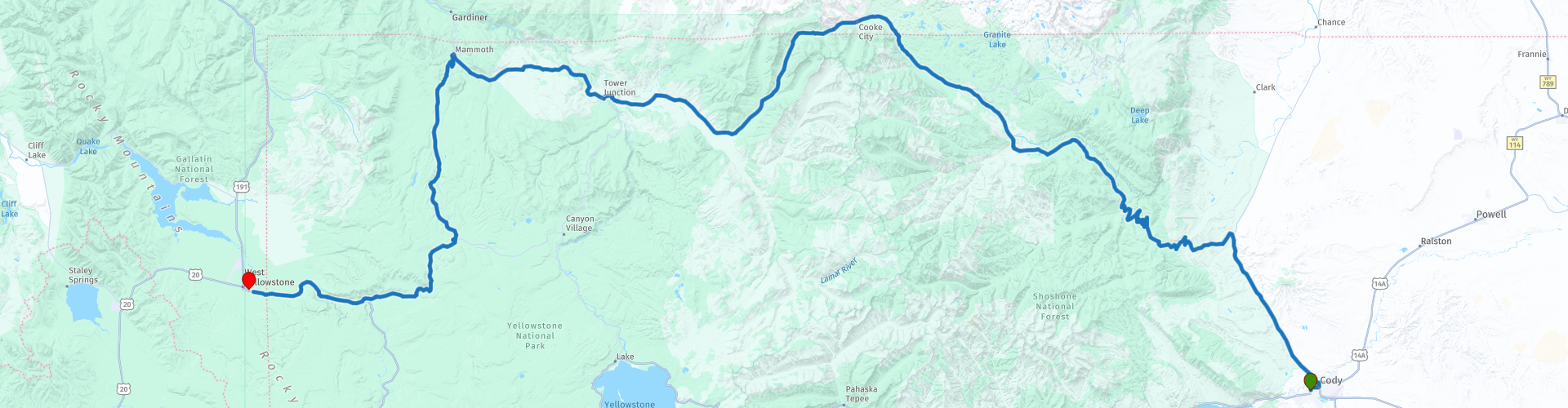
Starting point: BEST WESTERN Sunset Motor Inn
End point: Best Western Weston Inn.
The route has been made the same for TomTom, Garmin and MyRoute-app Navigation users.
Thanks to Richard & Lisa for the information!
 Share this route


Animation

Verdict


Duration
9h 47m

Mode of travel
Car or motorcycle

Distance
285.91 km

Countries

 RouteXpert Review
 spray dozens of meters of boiling and steaming water into the air. Grizzly bears, wolves, bison and wapiti deer live among other things. The most important route is the approximately 240 kilometer long (paved) 8-shaped Loop Road.
We start the route in the Shoshone National Forest, this is the first federally protected National Forest in the United States and covers nearly 2,500,000 hectares in the state of Wyoming. The first stop we do is at Dead Indian Overlook, you should definitely stop here. The view offers a wonderful view of the valley and the surrounding mountain peaks. The squirrels that are used to people will come to you hoping to get some food, it is better not to do this and let them find their natural food themselves. If it is not windy during your visit, you have experienced a rare moment. We drive on and soon arrive at the next stop, Sunlight Bridge Overlook, which offers an impressive view of an almost 90 meter deep gorge formed by Sunlight Creek that cuts through the granite. Because the gap is narrow, it is impossible to see the depth of the gap from your motorcycle - it is certainly worth the effort to park the motorcycle to enjoy the view.
The next longer stop is at Beartooth Cafe, you can stop here for coffee or lunch. This is located in the center of Soda Butte Valley and you have a nice view of the Beartooth Mountains. The next stop is at the Soda Butte Cone, the name "Soda Butte" comes from a large, largely dormant, hot spring cone that sits right next to the highway where Soda Butte Creek ends up in the Lamar Valley. The last wolves killed in Yellowstone during the eradication period of the wolves were killed near this hot spring cone. Nowadays wolves live in the area again.
We are now driving in Yellowstone National Park, which has an area of 8983 km², making it one of the largest national parks in the United States. We continue and then stop at the Forces of the Northern Range, walk this 1/2-mile Self-Guiding Trail on the Blacktail Deer Plateau and see and read how the forces of nature have shaped the land for you. We then stop in Mammoth for a drink while looking out at Capitol Hill. We also visit the Hot Springs Terraces, a large hot springs complex on a travertine hill in Yellowstone National Park adjacent to Fort Yellowstone and the historic Mammoth Hot Springs district. It was created for thousands of years as hot spring water cooled and deposited calcium carbonate.
We also stop at the Museum of the National Park Ranger, to visit the exhibitions about the history of the National Park Service and the forester. We also make a short stop at the Norris Geyser Basin Museum. Furthermore we stop at Gibbon Falls to take some pictures, here the water falls 26 meters down. The last stop before refueling and at the hotel is the viewpoint on Mount Haynes an impressive mountain of 2,505 meters.
In this 4-star route you will drive on beautiful good roads, a stop at Dead Indian Overlook and Soda Butte Cone is a must.
History:
Yellowstone is situated on an exceptionally large volcanic structure; the Yellowstone caldera. The caldera was formed 640,000 years ago during the last eruption. The enormous amount of ash and rock (1,000 km³) that was released during this period covered the entire west of the United States. A crater of 48 kilometers wide and 72 kilometers long was created. The volcanic system is still active, although scientists consider it unlikely that the volcano will erupt again in a short time. The geysers and hot springs in the park are direct proofs of the volcanic activity. The region was once nicknamed: "the area where hell is bubbling up."
In the nineteenth century the first furriers and pioneers discovered Yellowstone. Their imaginative stories about boilers full of simmering mud and steaming geysers reaching the sky soon reached the east coast of America. In 1871, Ferdinand Hayden led an expedition to Yellowstone, which included the painter Thomas Moran and the photographer William H. Jackson. They brought back images that convinced the government that the area needed to be protected and preserved. In 1872, President Ulysses Grant signed a law that declared Yellowstone to be forever a "public park for the good of people's enjoyment." The first US national park was born!
Yellowstone National Park made world news in 1988 with the most devastating forest fires in its history. After an unprecedented dry and hot summer, 36 percent of the park was destroyed. Seeing the charred forests, the whole country feared the worst for the National Park Service flagship. But what appeared on television as the darkest hour in Yellowstone's history was only the dramatic high point of a natural ecological cycle. The fire brigade did its best to control the sea of fire as much as possible, but eventually let nature take its course in a controlled manner. The fires would rage for a long time, until rain in the autumn the fire died out. We now know that the dead trees have made way for young growth, which can again grow into a healthy forest unhindered. Whoever enters Yellowstone can still see the old burnt trees here and there, sometimes they form a spooky backdrop against the backdrop of limestone rocks.


 Links
Links  Usage
Usage Want to download this route?
You can download the route for free without MyRoute-app account. To do so, open the route and click 'save as'. Want to edit this route?
No problem, start by opening the route. Follow the tutorial and create your personal MyRoute-app account. After registration, your trial starts automatically.  Disclaimer
Use of this GPS route is at your own expense and risk. The route has been carefully composed and checked by a MyRoute-app accredited RouteXpert for use on TomTom, Garmin and MyRoute-app Navigation.
Changes may nevertheless have occurred due to changed circumstances, road diversions or seasonal closures. We therefore recommend checking each route before use.
Preferably use the route track in your navigation system. More information about the use of MyRoute-app can be found on the website under 'Community' or 'Academy'.