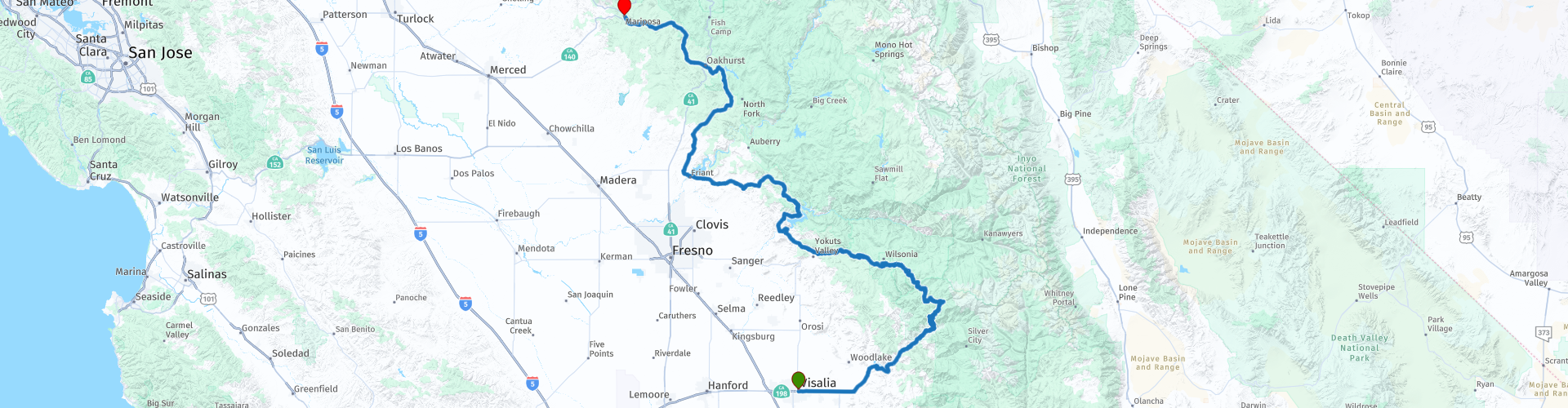
R11 Visalia Mariposa

This route was brought to you by:
RouteXpert Hans van de Ven (Mr.MRA)
Last edit: 01-02-2020
 Route Summary
 The previous route went through the south of Sequoia / Kings Canyon National Park, in this route you go through the park.
During this journey you will travel through the following states: California, Arizona, Utah & Nevada.
The roads are good, the views amazing. No shortage of bends and (giant) trees. A route where you can have a nice picnic along the way, don't forget to do the shopping!
Starting point: Visalia Marriott at the Convention Center.
End point: Mariposa Lodge.
The route has been made the same for TomTom, Garmin and MyRoute-app Navigation users.
Thanks to Richard & Lisa for the information!
 Share this route


Animation

Verdict


Duration
6h 26m

Mode of travel
Car or motorcycle

Distance
360.12 km

Countries

 RouteXpert Review
 The route starts with the 198 through an agricultural area, not really exciting, but then you go into the mountains and follow a more interesting part of the road, part of which runs along the water, turns guaranteed!
In this route you go through the Sequoia / Kings Canyon National Park. Not the entire park, because it is too big for that. What you are going to see are the giant Sequoia trees, the park also owes its name to this. No lack of curves in the park.
In this 4 star route you mainly drive on good roads, one or more stops in the Sequoia / Kings Canyon National Park you should definitely do. Take some food and drinks with you on the road!
General information:
Sequoia / Kings canyon National Park
These two areas are managed by the National Park Service under one park. The Kings Canyon National Park has an area of 1863 square kilometers and the Sequoia National Park has an area of 1631 square kilometers. The Kings Canyon National Park is an area with huge canyons, high steep rock faces, many lakes and waterfalls, mountain meadows and groups of redwood drones. The Sequoia National Park is of course the most important reserve for the largest and most powerful trees in the world. The main attractions in these two areas are the Giant Forest (a concentration of Sequoiadendrons), Crystal Cave (beautiful limestone formations), the High Sierra Trail (a footpath along beautiful Canyons) and the 4418 meter high Mount Whitney, which is part of the Sierra Nevada chain. Within the Sequoia park is the Great Western Divide - the natural obstacle that separates the rivers and creeks that flow to the west from those that flow to the east.
The park is in the central part of California. The highest summer temperature is around 38 degrees and the lowest around 17 degrees. The winters in the park are very cold and have a heavy snowfall. The Sequoiadendron is the largest organism in the world and the age of the General Sherman Tree is estimated at 2500 to 3000 years. The
Sequoiadendron is the last descendant of an ancient genus of giant forest giants.


 Links
Links  Usage
Usage Want to download this route?
You can download the route for free without MyRoute-app account. To do so, open the route and click 'save as'. Want to edit this route?
No problem, start by opening the route. Follow the tutorial and create your personal MyRoute-app account. After registration, your trial starts automatically.  Disclaimer
Use of this GPS route is at your own expense and risk. The route has been carefully composed and checked by a MyRoute-app accredited RouteXpert for use on TomTom, Garmin and MyRoute-app Navigation.
Changes may nevertheless have occurred due to changed circumstances, road diversions or seasonal closures. We therefore recommend checking each route before use.
Preferably use the route track in your navigation system. More information about the use of MyRoute-app can be found on the website under 'Community' or 'Academy'.