Day 2 Chattanooga to Stecoah

This route was brought to you by:
RouteXpert René Plücken (MRA Master)
Last edit: 12-02-2021
 Route Summary
 America is pre-eminently a country to explore on a motorcycle. There are many travel organizations that offer organized tours, but the charm is also to map out routes and drive on your own.
Good motorbike rental companies can be found throughout the country and the bikes are often of the latest model and well maintained.
We drive on the beautiful roads in the states of Nashville and North Carolina and this area is characterized by the beautiful idyllic landscape with provincial two-lane roads that wind through the landscape with many curves, you can visit beautiful towns, villages and places of interest.
Be careful though, because the roads are sometimes of very poor quality and hardly or not lit up in the dark.
For each route there is a more detailed description in the review.
The route is suitable for TomTom, Garmin, Harley-Davidson BoomBox 2 (2019 model) and MyRoute-app Navigation.
 Share this route


Animation

Verdict


Duration
4h 26m

Mode of travel
Car or motorcycle

Distance
272.48 km

Countries

 RouteXpert Review
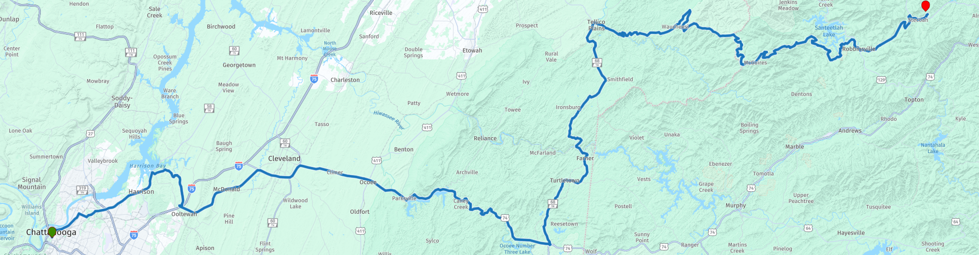
 We drive through the woods via US Highway 64 (S. Lee Highway) via Cleveland to the Cherokee National Forrest. This road already has a multitude of wonderful curves and leads us along the river and the lake of the same name Ocoee. At the village of Ducktown we leave the Highway and take the TN-68 north through the beautiful rolling and green landscape of Tennessee.
After we have crossed the Hiwassee river at RP11, the better cornering starts. After 30 kilometers we turn right at Tellico Pains onto the Cherohala Skyway, this road is a 69 kilometer long National Scenic Byway that connects Tellico Plains Tennessee with Robbinsville North Carolina. The name of this Skyway is a combination of Cherokee and Nantahala, the two national forests through which it goes.
At RP13 is a Cherohala Skyway visitors center where we can purchase a souvenir or gather some extra information about the area.
At RP14 we see the beautiful covered Telliquah bridge built by Tom Cormier to honor the past.
At RP15 is one of the Smoky Mountains Harley-Davidson Dealership and here we can stop for a T-Shirt or other souvenir or just enjoy the motorbikes. On the other side we can have lunch at Iron Works Grille.
At RP18 we leave the state of Tennessee and enter North Carolina and continue to the end of this beautiful winding Cherohala Skyway in Robbinsville (RP20), where we also refuel for the next day.
From here it is 20 kilometers to the end of this route at Iron Horse Motorcycle Lodge and Resort, where we stay for three days to enjoy the beautiful roads in this area.
This route is worth 4 **** stars because of the beautiful roads and beautiful panoramas in the 2nd part of the ride.


 Links
Links  Usage
Usage Want to download this route?
You can download the route for free without MyRoute-app account. To do so, open the route and click 'save as'. Want to edit this route?
No problem, start by opening the route. Follow the tutorial and create your personal MyRoute-app account. After registration, your trial starts automatically.  Disclaimer
Use of this GPS route is at your own expense and risk. The route has been carefully composed and checked by a MyRoute-app accredited RouteXpert for use on TomTom, Garmin and MyRoute-app Navigation.
Changes may nevertheless have occurred due to changed circumstances, road diversions or seasonal closures. We therefore recommend checking each route before use.
Preferably use the route track in your navigation system. More information about the use of MyRoute-app can be found on the website under 'Community' or 'Academy'.