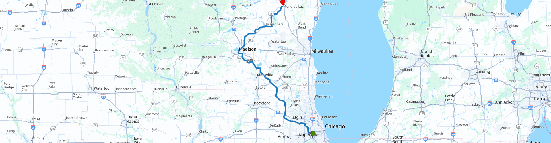
Chicago to Fond du Lac via Madison

This route was brought to you by:
RouteXpert Nick Carthew - (MRA Master)
Last edit: 29-10-2021
 Route Summary
 This route heads out of Chicago from EagleRider Motorcycle rental and visit 4 of the chain of 5 lakes of the Yahara River. The route uses mainly rural roads but some short sections of 4 lane highways are used to escape Chicago and Madison.
Good roads and scenery is why I have awarded 3*** stars.
 Share this route


Animation

Verdict


Duration
6h 18m

Mode of travel
Car or motorcycle

Distance
378.29 km

Countries

 RouteXpert Review
 Starting from EagleRider Motorcycle rental at Illinois Harley-Davidson in Chicago and ending in New York City.
This route heads out of the Chicago metropolis and before long you're into the suburbs and then crossing the Fox River at Elgin takes you into a more rural landscape where tall grain silos and green and yellow John Deere Tractors replace the hi-rise buildings and city traffic. The route passes through Woodstock (no, not that one!) which has a lovely historic town square making it a nice place for a short stop. You'll then go through Harvard (no, not that one!) and across the state line and into Wisconsin.
Wisconsin's geography is diverse, having been greatly impacted by glaciers during the Ice Age. More recently, during the 19th and early 20th centuries, European settlers entered the state, many of whom emigrated from Germany and Scandinavia and a lot of their culture is celebrated today.
Next on the route come a series of lakes the first being Lake Koshkonong. This was created when the Rock River was dammed a few miles downstream at Indianford during the depression in 1932. At 10,500 acres (42 km2), it's a very large lake but miniscule when compared to the Great Lakes. It remains very shallow with an average depth of just six feet (1.8 metres). You will meet up with the Rock River again, later in you journey.
A few miles further on is the Yahara River at RP 26. This river feeds and drains the 5 lakes of the Yahara River Chain, you will pass by 4 of these glacial lakes on the way to Madison. The Yahara River flows south before joining the Rock River which then goes on to flow into the mighty Mississippi. Linked by the Yahara River, all the Yahara Lakes formed during the last Ice Age. One of the glaciers that covered Wisconsin left behind boulders, rocks, sand, and silt when it melted. The debris damned sections of an old river valley, some believe to be the ancient Wisconsin River, and created the lakes.
Lake Kegonsa is the first you'll see, it gets its name from "Ke-go-e," the Chippewa word for fish, and it has been called the "Lake of Many Fishes." Early settlers called the lake First Lake because it was the first lake they came to when travelling north up the Yahara River.
Lake Waubesa is next, the 3rd largest lake in the chain and is home to 70 bird species and 11 mammal species. A fuel stop and McDonald's (other restaurants available) are at RP 30.
A bridge takes you over Lake Monona onto the land between 2 lakes; Lake Monona and Lake Mendota this forms Madison’s iconic isthmus. Madison is one of only two major U.S. cities to be located on an isthmus, the other being Seattle, Washington.
The Wisconsin State Capitol building is the tallest building in Madison, a distinction that has been preserved by legislation that prohibits buildings taller than the columns surrounding the dome (187 feet - 57 m). The locals in Madison like to brag that they come from one of the happiest cities in the United States, so it is no surprise that visitors to the capital city find that same joy.
RP 36 is at Lake Mendota lock, this controls water levels between the two lakes. Lake Mendota is the largest and deepest lake in the Yahara chain of lakes 83 feet (25 m). You will have noticed that nearly every lakeside house along this route has a boat in it's drive and Madison is no different, this really is boating country. The lakes are used all year round and with an average freeze date around the middle of December, activities such as ice skating, ice fishing and even ice yachting take over from the summer sports.
You'll leave Madison in a north easterly direction through more rural landscape passing fields of maize and other crops on the way to Beaver Dam and Beaver Dam Lake.
Beaver Dam was first settled by Thomas Mackie and Joseph Goetschius in 1841, and by 1843 had a population of almost 100 (with the help of MRS Mackie and Mrs Goetschius one hopes!). The city was named from an old beaver dam located in a stream flowing into the Beaver Dam River. Thye lake has a maximum depth of just 7 feet (2.1 m) and there are 26 islands ranging from 0.1 to 2.8 acres. All of the islands are privately owned. Several places to stop for a coffee, I have suggested another MackyDs.
A little further on from Beaver Dam is the Dodge County Fairgrounds. They have a 1/3 mile (535 m) oval gravel circuit and hold many events for both 2 wheels and four.
You meet up with the Rock River again at RP 48, some 60 miles (100 km) as the crow flies from your encounter at Lake Koshkonong. The Rock River is a major contributor to the Horicon Marsh National Wildlife Refuge that you will pass through.
Horicon Marsh area has been inhabited by humans, including the Paleo-Indians, the Hopewellian people and the Mound Builders, since the ending of the last Ice Age. Dozens of 1200 year old effigy mounds were built by the Mound Builders in the surrounding low ridges. Later the region was inhabited by the Potawotomi, primarily to the east of the marsh, and the Ho-Chunk to the west.
From here it's just 20 minutes to the end of the route and your hotel at Fond du Lac.


 Links
Links  Usage
Usage Want to download this route?
You can download the route for free without MyRoute-app account. To do so, open the route and click 'save as'. Want to edit this route?
No problem, start by opening the route. Follow the tutorial and create your personal MyRoute-app account. After registration, your trial starts automatically.  Disclaimer
Use of this GPS route is at your own expense and risk. The route has been carefully composed and checked by a MyRoute-app accredited RouteXpert for use on TomTom, Garmin and MyRoute-app Navigation.
Changes may nevertheless have occurred due to changed circumstances, road diversions or seasonal closures. We therefore recommend checking each route before use.
Preferably use the route track in your navigation system. More information about the use of MyRoute-app can be found on the website under 'Community' or 'Academy'.