D06 Vegas to Furnace Creek

This route was brought to you by:
RouteXpert Albert van den Elsen
Last edit: 25-07-2025
 Route Summary
 However, be aware of the dangers such as extreme heat in Death Valley, limited access to water, poor cell service, and long stretches without amenities — preparation is key.
Let yourself be enchanted, but be alert: the desert only reveals those who take it seriously.
This trip deserves a 5 out of 5 because it offers an unparalleled combination of natural beauty, historical significance, and sensory intensity that will stay with you long after.
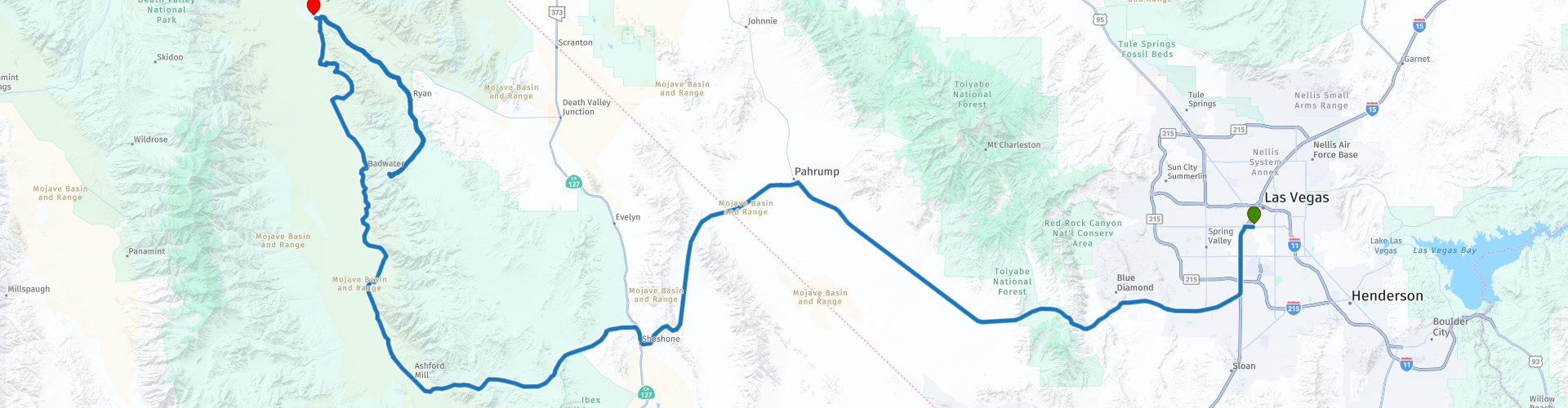
Start: Las Vegas, Clark County, Nevada
End point: Furnace Creek, California
 Share this route


Animation

Verdict


Duration
6h 45m

Mode of travel
Car or motorcycle

Distance
345.02 km

Countries

 RouteXpert Review
 Like an odyssey through stone and sand, before the sun casts its first glow over the horizon, you'll cut through the awakening city. The last glints of casino lights will dance briefly in your mirrors, a quickly fading reminder of the world you'll leave behind. The urban bustle will soon dissolve into the serene stillness of Blue Diamond Road. Here, at the foot of the imposing Mountain Springs range, the temperature will noticeably drop. The sharp scent of pine will disappear, replaced by the dry, shimmering air so characteristic of the Mojave Basin and Range. You'll breathe deeply, anticipation tightening in your chest.
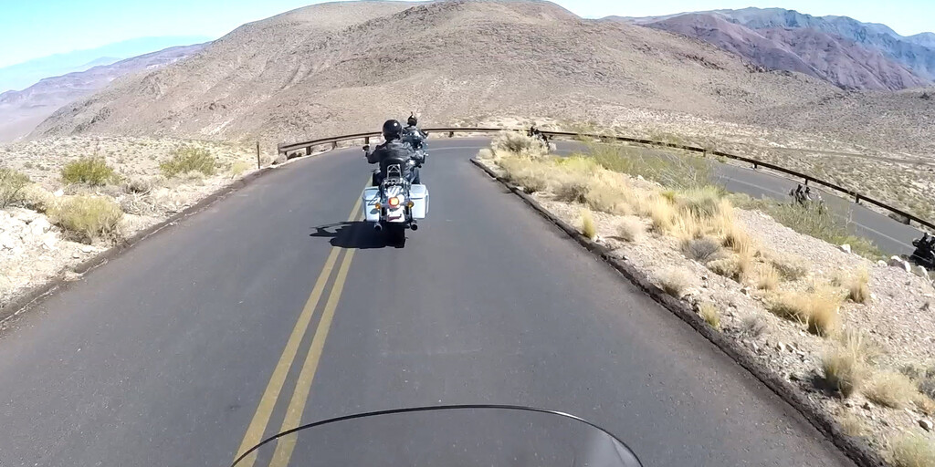
The climb to Mountain Springs Summit, at over 5,500 feet (1,675 meters), will reveal a breathtaking panorama. Below you, vast valleys will unfold, flanked by the rugged, untamed foothills of the Mount Charleston Wilderness. The wind will gently rustle your helmet, and you'll imagine the native tribes and pioneers who followed this same route centuries ago, searching for hope and a new life. Their stories will still seem to whisper in the gentle breeze.
After a gentle descent, you'll reach Pahrump. This village, fed by springs and shaped by agriculture and mining, will feel like an anchor in time. In the cozy Pahrump Snack Shop, you'll enjoy a well-deserved, leisurely breakfast, while your gaze wanders over the dusty streets and the modest Gold Town Casino. It'll be a step back into a simpler, slower life, a perfect transition to the deep wilderness that awaits you.
Your journey continues to Shoshone, a historic mining village where fewer than a hundred souls keep history alive. Once a bustling stop for travelers and miners in the early 20th century, it will then become the gateway to the legendary Death Valley National Park. You'll enter via the iconic Jubilee Pass, and a sense of deep reverence will overtake you.
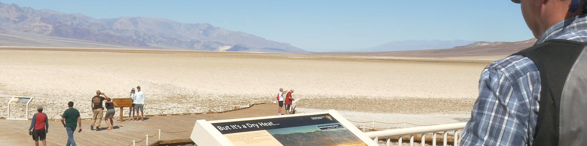
You'll dismount your motorcycle at a breathtaking viewpoint: Death Valley itself. Known as one of the hottest places on earth, it will reveal itself as a canvas of geological wonders, a symphony of untamed beauty. History will hang heavy in the air—stories of intrepid gold prospectors and courageous emigrants who sought their fortune here, often finding their fate. With respect for those who survived this heat, every grain of sand will seem to bear a memory.
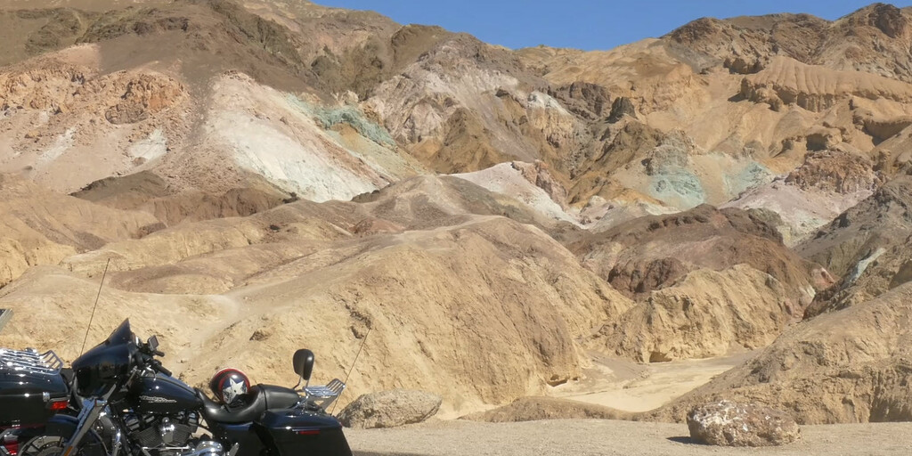
A little further on, at Artists Palet, a surreal spectacle will unfold. Colorful hills will captivate your gaze, where minerals like iron, mica, and manganese will have painted the earth in pastel shades of pink, green, yellow, and purple. These natural works of art, formed by millions of years of volcanism and relentless erosion, will be a powerful testament to the primal power of our planet. It will feel as if the Earth itself is revealing its deepest secrets in an explosion of color.
The winding climb to Dante's View will be a highlight you'll never forget. From 5,500 feet (1,660 meters), your gaze will stretch across Badwater Basin, the lowest point in North America. The salt flats will glisten like polished marble under the merciless sun, while the imposing Panamint Range will rise like an unyielding stone wall on the other side. Here, a deep, reverent silence will reign—a silence broken only by the overwhelming realization of your own insignificance amidst this vast, timeless void.
The road slowly descends to Furnace Creek, where the stifling heat surprisingly gives way to liveliness. Once an essential stop for weary travelers, it now forms a small bastion of comfort in the heart of the desert. You'll find a fascinating museum, an informative visitor center, and—perhaps most refreshing of all—a cooling pool. As your body relaxes in the water, your understanding of human resilience grows: the ability to thrive in the face of unforgiving circumstances.
The day ends in one of the comfortable lofts, where the still breath of the desert embraces you. Memories drift down like dust in the evening light. A fuel stop is scheduled first thing in the morning—practical and necessary. But the most remarkable thing here? No 4G or 5G in sight. Conversations arise spontaneously, traditionally, and sincerely.
This journey was much more than asphalt under your wheels. It became a sensory pilgrimage along the rugged edges of nature, steeped in history, geological wonders, and an intense sense of awe. What at first seemed empty and barren turned out to be overflowing with stories, color, and quiet lessons for those willing to truly listen. An experience that settles in your memory like desert sand—lasting, timeless.
 Links
Links  Usage
Usage Want to download this route?
You can download the route for free without MyRoute-app account. To do so, open the route and click 'save as'. Want to edit this route?
No problem, start by opening the route. Follow the tutorial and create your personal MyRoute-app account. After registration, your trial starts automatically.  Disclaimer
Use of this GPS route is at your own expense and risk. The route has been carefully composed and checked by a MyRoute-app accredited RouteXpert for use on TomTom, Garmin and MyRoute-app Navigation.
Changes may nevertheless have occurred due to changed circumstances, road diversions or seasonal closures. We therefore recommend checking each route before use.
Preferably use the route track in your navigation system. More information about the use of MyRoute-app can be found on the website under 'Community' or 'Academy'.

California
About this region
California is a state in the Western United States. It shares a border with Oregon to the north, Nevada and Arizona to the east, and the Mexican state of Baja California to the south. With over 39.5 million residents across a total area of approximately 163,696 square miles (423,970 km2), it is the most populous and the third-largest U.S. state by area. It is also the most populated subnational entity in North America and the 34th most populous in the world. The Greater Los Angeles area and the San Francisco Bay Area are the nation's second and fifth most populous urban regions respectively, with the former having more than 18.7 million residents and the latter having over 9.6 million. Sacramento is the state's capital, while Los Angeles is the most populous city in the state and the second most populous city in the country (after New York City). Los Angeles County is the country's most populous, while San Bernardino County is the largest county by area in the country. San Francisco, which is both a city and a county, is the second most densely populated major city in the country (after New York City) and the fifth most densely populated county in the country, behind four of New York City's five boroughs.
The economy of California, with a gross state product of $3.2 trillion as of 2019, is the largest sub-national economy in the world. If it were a country, it would be the 37th most populous country and the fifth largest economy as of 2020. The Greater Los Angeles area and the San Francisco Bay Area are the nation's second- and third-largest urban economies ($1.0 trillion and $0.5 trillion respectively as of 2020), after the New York metropolitan area ($1.8 trillion). The San Francisco Bay Area Combined Statistical Area had the nation's highest gross domestic product per capita ($106,757) among large primary statistical areas in 2018, and is home to five of the world's ten largest companies by market capitalization and four of the world's ten richest people.Prior to European colonization, California was one of the most culturally and linguistically diverse areas in pre-Columbian North America and contained the highest Native American population density north of what is now Mexico. European exploration in the 16th and 17th centuries led to the colonization of California by the Spanish Empire. In 1804, it was included in Alta California province within the Viceroyalty of New Spain. The area became a part of Mexico in 1821, following its successful war for independence, but was ceded to the United States in 1848 after the Mexican–American War. The western portion of Alta California was then organized and admitted as the 31st state on September 9, 1850, following the Compromise of 1850. The California Gold Rush started in 1848 and led to dramatic social and demographic changes, including large-scale immigration into California, a worldwide economic boom, and the California genocide of indigenous people.
Notable contributions to popular culture, for example in entertainment and sports, have their origins in California. The state also has made noteworthy contributions in the fields of communication, information, innovation, environmentalism, economics, and politics. It is the home of Hollywood, the oldest and largest film industry in the world, which has had a profound effect on global entertainment. It is considered the origin of the hippie counterculture, beach and car culture, and the personal computer, among other innovations. The San Francisco Bay Area and the Greater Los Angeles Area are widely seen as centers of the global technology and entertainment industries, respectively. California's economy is very diverse: 58% of it is based on finance, government, real estate services, technology, and professional, scientific, and technical business services. Although it accounts for only 1.5% of the state's economy, California's agriculture industry has the highest output of any U.S. state. California's ports and harbors handle about a third of all U.S. imports, most originating in Pacific Rim international trade.
The state's extremely diverse geography ranges from the Pacific Coast and metropolitan areas in the west to the Sierra Nevada mountains in the east, and from the redwood and Douglas fir forests in the northwest to the Mojave Desert in the southeast. The Central Valley, a major agricultural area, dominates the state's center. Although California is well known for its warm Mediterranean climate and monsoon seasonal weather, the large size of the state results in climates that vary from moist temperate rainforest in the north to arid desert in the interior, as well as snowy alpine in the mountains. All these factors lead to an enormous demand for water. Over time, droughts and wildfires have increased in frequency and become less seasonal and more year-round, further straining California's water security.
Read more on Wikipedia
The economy of California, with a gross state product of $3.2 trillion as of 2019, is the largest sub-national economy in the world. If it were a country, it would be the 37th most populous country and the fifth largest economy as of 2020. The Greater Los Angeles area and the San Francisco Bay Area are the nation's second- and third-largest urban economies ($1.0 trillion and $0.5 trillion respectively as of 2020), after the New York metropolitan area ($1.8 trillion). The San Francisco Bay Area Combined Statistical Area had the nation's highest gross domestic product per capita ($106,757) among large primary statistical areas in 2018, and is home to five of the world's ten largest companies by market capitalization and four of the world's ten richest people.Prior to European colonization, California was one of the most culturally and linguistically diverse areas in pre-Columbian North America and contained the highest Native American population density north of what is now Mexico. European exploration in the 16th and 17th centuries led to the colonization of California by the Spanish Empire. In 1804, it was included in Alta California province within the Viceroyalty of New Spain. The area became a part of Mexico in 1821, following its successful war for independence, but was ceded to the United States in 1848 after the Mexican–American War. The western portion of Alta California was then organized and admitted as the 31st state on September 9, 1850, following the Compromise of 1850. The California Gold Rush started in 1848 and led to dramatic social and demographic changes, including large-scale immigration into California, a worldwide economic boom, and the California genocide of indigenous people.
Notable contributions to popular culture, for example in entertainment and sports, have their origins in California. The state also has made noteworthy contributions in the fields of communication, information, innovation, environmentalism, economics, and politics. It is the home of Hollywood, the oldest and largest film industry in the world, which has had a profound effect on global entertainment. It is considered the origin of the hippie counterculture, beach and car culture, and the personal computer, among other innovations. The San Francisco Bay Area and the Greater Los Angeles Area are widely seen as centers of the global technology and entertainment industries, respectively. California's economy is very diverse: 58% of it is based on finance, government, real estate services, technology, and professional, scientific, and technical business services. Although it accounts for only 1.5% of the state's economy, California's agriculture industry has the highest output of any U.S. state. California's ports and harbors handle about a third of all U.S. imports, most originating in Pacific Rim international trade.
The state's extremely diverse geography ranges from the Pacific Coast and metropolitan areas in the west to the Sierra Nevada mountains in the east, and from the redwood and Douglas fir forests in the northwest to the Mojave Desert in the southeast. The Central Valley, a major agricultural area, dominates the state's center. Although California is well known for its warm Mediterranean climate and monsoon seasonal weather, the large size of the state results in climates that vary from moist temperate rainforest in the north to arid desert in the interior, as well as snowy alpine in the mountains. All these factors lead to an enormous demand for water. Over time, droughts and wildfires have increased in frequency and become less seasonal and more year-round, further straining California's water security.
View region
 Statistics
  50
50Amount of RX reviews (California)
 31584
31584Amount of visitors (California)
 823
823Amount of downloads (California)
 Route Collections in this region
 Car or motorcycle tour through the western US
This collection contains all 15 routes driven by MRA Goldmember André ter Schegget during his three-week tour through the west of America.
The places to visit, the attractions and beautiful photo spots are nicely marked on the routes. The routes have been fully checked and made equal for the Garmin and the TomTom. Enjoy this wonderful trip and let us know how it was! Enjoy and stay safe!
Order of the tour:
Route 01: from Los Angeles and via Pacific Coast Highway to Solvang
Route 02: Solvang to Monterey / Pacific Grove
Route 03A: Monterey to San Francisco
Route 03B: if you are by car instead of the motorcycle, as motorcycles are not allowed on the 17 Mile Drive: from Monterey to the 17 Mile Drive and further to San Francisco
Route 04: from San Francisco via Nappa and Eldorado National Forrest to Topaz Lake
Route 05: from Topaz Lake via Bodie and Yosemite to Oakhurst
Route 06: from Oakhurst via Kings Canyon NP and Sequoia NP and Giant Forest to Exeter
Route 07: Exeter via Isabella Lake and Ridgecrest to Death Valley
Route 08: from Death Valley via Valley Of Fire to Mesquite
Route 09: from Mesquite via Zion NP and Dixie NF to Hatch
Route 10: Hatch via Bryce Canyon to Page
Route 11: from Page via Grand Canyon to Williams
Route 12: from Williams via Seligman and Route 66 to Kingman and via Hoover Dam to Las Vegas
Route 13: from Las Vegas via Oatman and Lake Havasu to Parker
Route 14: from Parker via Joshua Tree to Rancho Mirage
Route 15: Rancho Mirage via Palm Springs to Santa Monica
View Route Collection
The 10 most downloaded routes in the USA from RouteXpert Hans van de Ven
Hello and welcome to this collection of the Top 10 MyRoute app downloaded routes in USA.
There will be a great new event to be announced soon, where all these routes can be driven.
Download them all now and place them in a new "Top 10" folder, so that you always have them at hand.
If you are going to drive one of these routes in the meantime, track them with the MRA Mobile App or with MRA Navigation. Take some photos (moments) along the way as these will come in handy.
Create a travelogue of your Top 10 driven routes and add the recorded track to it.
There will also be some great prizes on offer, so keep an eye on the MRA-RouteXperts page and your mail.
The 10 routes are:
1. D13 Estes Park Denver
2. D03 Chadron Custer
3. D01 Pigeon Forge round trip through the Smokey Mountains
4. D08 Kalispell Sandpoint
5. D10 Colville Wenatchee
6. D09 Sandpoint Colville
7. D04 Custer Wall
8. D11 Wenatchee Seattle
9. D08 Cody Yellowstone NP
10.R13 San Francisco Monterey
View Route Collection