R15 Santa Barbara Los Angeles

This route was brought to you by:
RouteXpert Hans van de Ven (Mr.MRA)
Last edit: 01-02-2020
 Route Summary
 During this journey you will travel through the following states: California, Arizona, Utah & Nevada.
The roads are good, the views amazing. Enjoy along the coast, and watch homes in Hollywood Hills.
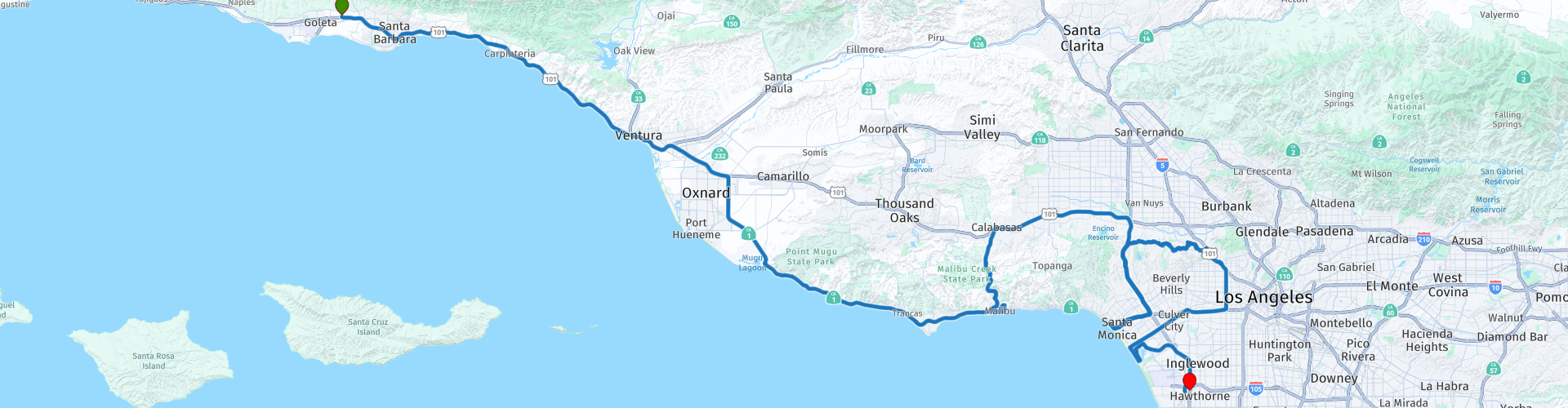
Starting point: Ramada Santa Barbara.
End point: Tradewinds Airport Hotel.
The route has been made the same for TomTom, Garmin and MyRoute-app Navigation users.
Thanks to Richard & Lisa for the information!
 Share this route


Animation

Verdict


Duration
3h 42m

Mode of travel
Car or motorcycle

Distance
231.04 km

Countries

 RouteXpert Review
 Take a look at how the stars of the silver screen live in the hills of Hollywood, do not be shocked by the number of yachts in the marina "Marina del Rey", but enjoy all this splendor, before you know it you will be home again!
In this 4-star route you will drive along the coastline, where there are plenty of opportunities to stop for a picnic on the coast. Don't forget your picnic stuff!
General information:
Los Angeles is a city that has appealed to the imagination for years. In the eyes of the world it is a fairy land of skyscrapers and movie stars. In the past, the film studios shot up like mushrooms, and the city also experienced phenomenal growth. Los Angeles now has almost 4 million inhabitants, making it the second largest city in America. The entire metropolis - Los Angeles and its suburbs - has no fewer than 14 million inhabitants. With that, she accounts for almost half of the total population of California (33 million), while extending to almost a hundred kilometers from the center. A Spanish expedition looking for the Bay of Monterey first established a settlement here in 1769. Twelve years later Governor Felipe de Neve and 11 families founded El Pueblo de Nuestra Senora la Reina de Los Angeles (The Village of Our Lady) the Queen of Angels). When Mexico gained independence from Spain in the early 19th century, LA became the temporary capital of the Mexican province of Alta California. It was the last area to be conquered by the United States during the Mexican war in 1847. After that, the small village gradually grew into a successful animal husbandry, agricultural and trade center. In a more recent past, Los Angeles has grown primarily through the development of a large number of different industries. The film industry in particular has become world famous. No less than three-quarters of all films produced in America see the first daylight in Los Angeles. In addition to the many film studios, countless major television and radio companies have settled in this city, and that has made Los Angeles the undisputed entertainment center of the world. In a large metropolis such as this one can hardly live without a car. It is therefore not surprising that there are around six million cars in LA. That is more than a third of all California-registered vehicles. More than 800 kilometers of highways have been built to connect the many residential areas of Los Angeles. Nowhere else in America are there more single-family homes together than here. The enormous horizontal growth of LA, which had no equal in the world, was possible because large tracts of land were available around the city. In addition, the "Californian dream" continued to attract people throughout America and the rest of the world. Of course the popularity of Los Angeles also has a shadow side, especially the infamous smog that hangs over the city almost every day. As you approach Los Angeles from the air, you may notice this brown blanket over the valley.
The first Spanish explorers who reached the Bay of Santa Monica in the 16th century already saw a smoky mist hanging in the air. The fires that the local Indians lit every day spread a smoke that was driven further inland by a gentle sea breeze. The smoke was, as it were, trapped in the valley and could
do not spread. Industrialization was continuous throughout the next four centuries, and many more millions of cars were added this century. As a result, this natural phenomenon grew into a national disaster with dramatic consequences. The sunny climate of California turns the exhaust fumes from motor vehicles into a visible layer trapped by the poor air circulation in the valley. Fortunately, the air quality has noticeably improved due to the technological developments of the last 20 years. In this way both the local population and the visitors can fully enjoy the beauty of the City of Angels.


 Links
Links  Usage
Usage Want to download this route?
You can download the route for free without MyRoute-app account. To do so, open the route and click 'save as'. Want to edit this route?
No problem, start by opening the route. Follow the tutorial and create your personal MyRoute-app account. After registration, your trial starts automatically.  Disclaimer
Use of this GPS route is at your own expense and risk. The route has been carefully composed and checked by a MyRoute-app accredited RouteXpert for use on TomTom, Garmin and MyRoute-app Navigation.
Changes may nevertheless have occurred due to changed circumstances, road diversions or seasonal closures. We therefore recommend checking each route before use.
Preferably use the route track in your navigation system. More information about the use of MyRoute-app can be found on the website under 'Community' or 'Academy'.

California
About this region
California is a state in the Western United States. It shares a border with Oregon to the north, Nevada and Arizona to the east, and the Mexican state of Baja California to the south. With over 39.5 million residents across a total area of approximately 163,696 square miles (423,970 km2), it is the most populous and the third-largest U.S. state by area. It is also the most populated subnational entity in North America and the 34th most populous in the world. The Greater Los Angeles area and the San Francisco Bay Area are the nation's second and fifth most populous urban regions respectively, with the former having more than 18.7 million residents and the latter having over 9.6 million. Sacramento is the state's capital, while Los Angeles is the most populous city in the state and the second most populous city in the country (after New York City). Los Angeles County is the country's most populous, while San Bernardino County is the largest county by area in the country. San Francisco, which is both a city and a county, is the second most densely populated major city in the country (after New York City) and the fifth most densely populated county in the country, behind four of New York City's five boroughs.
The economy of California, with a gross state product of $3.2 trillion as of 2019, is the largest sub-national economy in the world. If it were a country, it would be the 37th most populous country and the fifth largest economy as of 2020. The Greater Los Angeles area and the San Francisco Bay Area are the nation's second- and third-largest urban economies ($1.0 trillion and $0.5 trillion respectively as of 2020), after the New York metropolitan area ($1.8 trillion). The San Francisco Bay Area Combined Statistical Area had the nation's highest gross domestic product per capita ($106,757) among large primary statistical areas in 2018, and is home to five of the world's ten largest companies by market capitalization and four of the world's ten richest people.Prior to European colonization, California was one of the most culturally and linguistically diverse areas in pre-Columbian North America and contained the highest Native American population density north of what is now Mexico. European exploration in the 16th and 17th centuries led to the colonization of California by the Spanish Empire. In 1804, it was included in Alta California province within the Viceroyalty of New Spain. The area became a part of Mexico in 1821, following its successful war for independence, but was ceded to the United States in 1848 after the Mexican–American War. The western portion of Alta California was then organized and admitted as the 31st state on September 9, 1850, following the Compromise of 1850. The California Gold Rush started in 1848 and led to dramatic social and demographic changes, including large-scale immigration into California, a worldwide economic boom, and the California genocide of indigenous people.
Notable contributions to popular culture, for example in entertainment and sports, have their origins in California. The state also has made noteworthy contributions in the fields of communication, information, innovation, environmentalism, economics, and politics. It is the home of Hollywood, the oldest and largest film industry in the world, which has had a profound effect on global entertainment. It is considered the origin of the hippie counterculture, beach and car culture, and the personal computer, among other innovations. The San Francisco Bay Area and the Greater Los Angeles Area are widely seen as centers of the global technology and entertainment industries, respectively. California's economy is very diverse: 58% of it is based on finance, government, real estate services, technology, and professional, scientific, and technical business services. Although it accounts for only 1.5% of the state's economy, California's agriculture industry has the highest output of any U.S. state. California's ports and harbors handle about a third of all U.S. imports, most originating in Pacific Rim international trade.
The state's extremely diverse geography ranges from the Pacific Coast and metropolitan areas in the west to the Sierra Nevada mountains in the east, and from the redwood and Douglas fir forests in the northwest to the Mojave Desert in the southeast. The Central Valley, a major agricultural area, dominates the state's center. Although California is well known for its warm Mediterranean climate and monsoon seasonal weather, the large size of the state results in climates that vary from moist temperate rainforest in the north to arid desert in the interior, as well as snowy alpine in the mountains. All these factors lead to an enormous demand for water. Over time, droughts and wildfires have increased in frequency and become less seasonal and more year-round, further straining California's water security.
Read more on Wikipedia
The economy of California, with a gross state product of $3.2 trillion as of 2019, is the largest sub-national economy in the world. If it were a country, it would be the 37th most populous country and the fifth largest economy as of 2020. The Greater Los Angeles area and the San Francisco Bay Area are the nation's second- and third-largest urban economies ($1.0 trillion and $0.5 trillion respectively as of 2020), after the New York metropolitan area ($1.8 trillion). The San Francisco Bay Area Combined Statistical Area had the nation's highest gross domestic product per capita ($106,757) among large primary statistical areas in 2018, and is home to five of the world's ten largest companies by market capitalization and four of the world's ten richest people.Prior to European colonization, California was one of the most culturally and linguistically diverse areas in pre-Columbian North America and contained the highest Native American population density north of what is now Mexico. European exploration in the 16th and 17th centuries led to the colonization of California by the Spanish Empire. In 1804, it was included in Alta California province within the Viceroyalty of New Spain. The area became a part of Mexico in 1821, following its successful war for independence, but was ceded to the United States in 1848 after the Mexican–American War. The western portion of Alta California was then organized and admitted as the 31st state on September 9, 1850, following the Compromise of 1850. The California Gold Rush started in 1848 and led to dramatic social and demographic changes, including large-scale immigration into California, a worldwide economic boom, and the California genocide of indigenous people.
Notable contributions to popular culture, for example in entertainment and sports, have their origins in California. The state also has made noteworthy contributions in the fields of communication, information, innovation, environmentalism, economics, and politics. It is the home of Hollywood, the oldest and largest film industry in the world, which has had a profound effect on global entertainment. It is considered the origin of the hippie counterculture, beach and car culture, and the personal computer, among other innovations. The San Francisco Bay Area and the Greater Los Angeles Area are widely seen as centers of the global technology and entertainment industries, respectively. California's economy is very diverse: 58% of it is based on finance, government, real estate services, technology, and professional, scientific, and technical business services. Although it accounts for only 1.5% of the state's economy, California's agriculture industry has the highest output of any U.S. state. California's ports and harbors handle about a third of all U.S. imports, most originating in Pacific Rim international trade.
The state's extremely diverse geography ranges from the Pacific Coast and metropolitan areas in the west to the Sierra Nevada mountains in the east, and from the redwood and Douglas fir forests in the northwest to the Mojave Desert in the southeast. The Central Valley, a major agricultural area, dominates the state's center. Although California is well known for its warm Mediterranean climate and monsoon seasonal weather, the large size of the state results in climates that vary from moist temperate rainforest in the north to arid desert in the interior, as well as snowy alpine in the mountains. All these factors lead to an enormous demand for water. Over time, droughts and wildfires have increased in frequency and become less seasonal and more year-round, further straining California's water security.
View region
 Statistics
  51
51Amount of RX reviews (California)
 36813
36813Amount of visitors (California)
 859
859Amount of downloads (California)
 Route Collections in this region
 Top car and motorcycle tour through the west of the USA
By car or motorcycle through the West of America is a journey that you do not just make, so also not driving 15 days and then back home. No, book a stay of several days in Los Angeles, Las Vegas, San Francisco and again Los Angeles to also visit several places of interest in these cities, so that this tour becomes an unforgettable tour that you can remember with pleasure.
Do not forget to arrange and pack the following items:
*This is only a summary and completely personal and may differ per person.
Take out travel insurance, +31 for numbers in GSM, (partially) take out gas, Health insurance coverage at destination?, Switch off electrical appliances, Lighting (time clock), Check passport validity, Antenna from radio/TV due to lightning, Residence address for those left behind, Remote control house alarm, Book Smart Parking.
Hand luggage:
Liquids in packaging of max. 100 ml, Liquids in hand luggage in transparent plastic bag.
For on the road:
Candy, Book, Earplugs, Country and road map(s), Directions, Maps in your navigation system
Money & Securities:
Bank card / giro card, Credit card (think pin code), Cash, Calculator for Internet banking, Medical insurance card, Travel insurance card.
Travel documents:
Passport, (International) Driver's License, Ticket(s), Reservation Tickets, Hotel Vouchers, Arrival/Departure Time, Check-in & Check-out Times, Valid Visa (ESTA), Travel Guide.
Clothing:
Underwear, Belt, Shirts/ T-shirts, Shorts, Long pants, Shoes, Socks, Swim trunks, Towel, Slippers.
Personal stuff:
Watch, House Keys, Wallet, Sunglasses.
Toiletries:
Deodorant, Shower gel / Soap, Comb / brush, Shaving equipment, Shampoo, Toothbrush, Toothpaste, Sanitary pads
Health & Medicine:
Own medicines, Insect repellent, Cold sore ointment, Ointment for insect bites, Sunscreen, Norit, Paracetamol, Suction cup for insect bites, First aid bag.
Miscellaneous:
Travel bag / waist bag, Leatherman (= checked luggage), Pen or pencil, Headlamp, Lighter, Tools & Electronics, Mobile phone & charger, Photo/video camera & charger, Memory card(s), World plug / adapter, Ipod & charger, Adapter cable Ipod, Headphones, iPad & charger, Navigation & charger/plug, Plug socket, Fuelpack battery.
Engine (accessories):
Helmet, Motorcycle clothing, Motorcycle boots, Chain lock / disc brake lock, Gloves, Bandana, Inner bags (plastic shopping bag), Insulation bag, Tension straps, Tie wraps, Rain suit, Rainaway.
Addresses:
Address list, Embassy telephone number, Telephone number to block (bank) card(s), Telephone number (airline tickets).
View Route Collection
The 10 most downloaded routes in the USA from RouteXpert Hans van de Ven
Hello and welcome to this collection of the Top 10 MyRoute app downloaded routes in USA.
There will be a great new event to be announced soon, where all these routes can be driven.
Download them all now and place them in a new "Top 10" folder, so that you always have them at hand.
If you are going to drive one of these routes in the meantime, track them with the MRA Mobile App or with MRA Navigation. Take some photos (moments) along the way as these will come in handy.
Create a travelogue of your Top 10 driven routes and add the recorded track to it.
There will also be some great prizes on offer, so keep an eye on the MRA-RouteXperts page and your mail.
The 10 routes are:
1. D13 Estes Park Denver
2. D03 Chadron Custer
3. D01 Pigeon Forge round trip through the Smokey Mountains
4. D08 Kalispell Sandpoint
5. D10 Colville Wenatchee
6. D09 Sandpoint Colville
7. D04 Custer Wall
8. D11 Wenatchee Seattle
9. D08 Cody Yellowstone NP
10.R13 San Francisco Monterey
View Route Collection