Clemson loop via Cherokee Foothills Scenic Highway in SC

This route was brought to you by:
RouteXpert Lenny O
Last edit: 02-03-2026
 Route Summary
 If you like to hike for the views and waterfalls, this route will offer such options, or you can just enjoy the roads with some stops.
The route starts in Clemson, a charming University town.
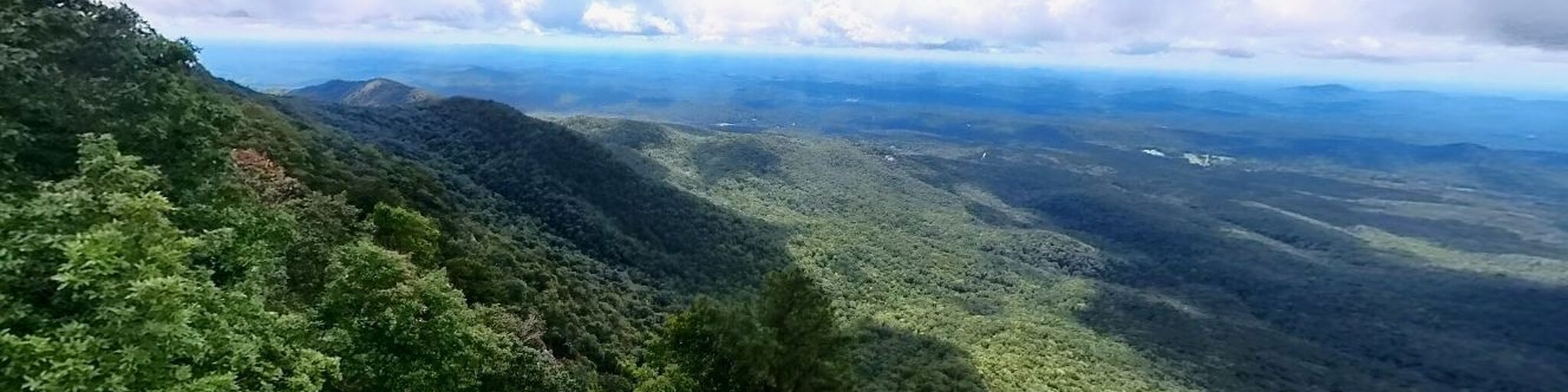
Head north on Cherokee Foothills Scenic Highway along the shores of Lake Keowee until you reach the Table Rock State Park.
It’s worth taking a quick loop through the park to soak in the iconic mountain views.
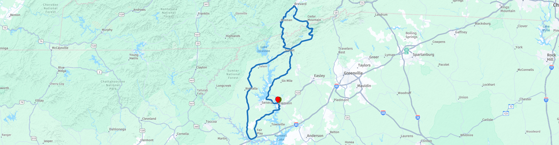
From there, rejoin the Foothills Highway and transition onto US-276 North, climbing toward Caesars Head State Park.
Don't miss the short walk to the observation platform - the views are stunning.
Also, squeeze through the narrow rock passage known as the Devil’s Kitchen.
As an option, hike to the Raven Cliff Falls. Don't miss a stop and a short walk to enjoy the view of the Connestee Falls.
Continue across the state line for a relaxing break in Brevard, NC—another quintessential mountain town perfect for a caffeine recharge.
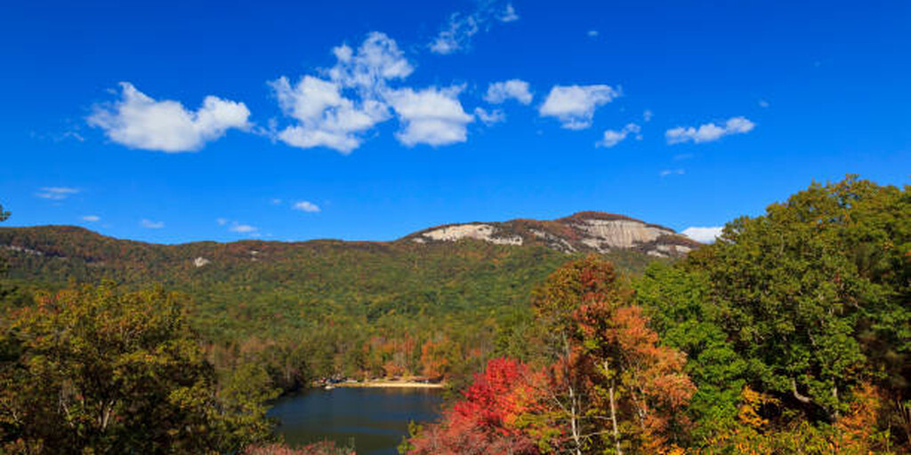
The return leg takes you south through a thrilling mix of technical mountain 'twisties' and sweeping open-country roads, eventually landing you back in Clemson.
With its diverse terrain and engaging roads, this route is a solid 4-star ride for anyone seeking a pleasant day in the saddle.
 Share this route


Animation

Verdict


Duration
5h 43m

Mode of travel
Car or motorcycle

Distance
257.32 km

Countries

 RouteXpert Review
 A ride along the Cherokee Foothills Scenic Highway (SC Hwy 11) offers a 130-mile journey through the rolling Piedmont foothills, featuring scenic views of the Blue Ridge Mountains, historic sites, state parks, and rural landscapes.
The route is perfect for a leisurely drive, highlighting South Carolina's natural beauty, particularly during autumn, with numerous points of interest along the way.
Table Rock State Park features stunning panoramic views of the Blue Ridge Mountains and Lake Oolenoy, with top viewpoints including the 3,124-foot Table Rock Summit, Governor’s Rock (2,800 ft), and Bald Knob.
The park is known for its strenuous 3.6-mile trail to the summit, offering breathtaking vistas.
At minimum, enjoy a quick loop through the park to soak in the iconic mountain views.
From there, rejoin the Foothills Highway and transition onto US-276 North, climbing toward Caesars Head State Park.
Highly recommend to stop at the Caesars Head State Park.
Trails throughout the park offer beautiful views of the mountainous landscape.
The short path to the viewing area that overlooks the Caesars Head rock passes through another intriguingly named geological curiosity,
a narrow passageway between two giant rocks, called "Devils Kitchen."
When the trail reaches Devils Kitchen, a set of stairs descends deep down into the rocky gap, which is just wide enough for a person to pass through. The formation was created thousands of years ago, as water on the mountain froze and expanded, causing the rock to crack open from the pressure. The granitic gneiss, a type of metamorphic rock, breaks at a 90-degree angle when it cracks, which formed the narrow passage flanked by tall rock walls.
If you are up to some serious hiking, you may stop and visit the Raven Cliff Falls just up the road.
It is a pretty good hike to get there, but the views are worth it!
Stop and enjoy a short walk to view the Connestee Falls and then continue enjoying the road and the scenery to a well-deserved break in Brevard, NC.
This charming mountain town is the perfect spot to refuel and explore local shops.
To wrap up the loop, head south through the "mountain twisties" and open vistas as you cruise back into Clemson.
 Links
Links  Usage
Usage Want to download this route?
You can download the route for free without MyRoute-app account. To do so, open the route and click 'save as'. Want to edit this route?
No problem, start by opening the route. Follow the tutorial and create your personal MyRoute-app account. After registration, your trial starts automatically.  Disclaimer
Use of this GPS route is at your own expense and risk. The route has been carefully composed and checked by a MyRoute-app accredited RouteXpert for use on TomTom, Garmin and MyRoute-app Navigation.
Changes may nevertheless have occurred due to changed circumstances, road diversions or seasonal closures. We therefore recommend checking each route before use.
Preferably use the route track in your navigation system. More information about the use of MyRoute-app can be found on the website under 'Community' or 'Academy'.

South Carolina
About this region
South Carolina is a state in the coastal southeastern region of the United States. It is bordered to the north by North Carolina, to the southeast by the Atlantic Ocean, and to the southwest by Georgia across the Savannah River. South Carolina is the 40th most extensive and 23rd most populous U.S. state with a recorded population of 5,124,712 according to the 2020 census. In 2019, its GDP was $213.45 billion. South Carolina is composed of 46 counties. The capital is Columbia with a population of 133,273 in 2019; while its largest city is Charleston with a 2020 population of 150,277. The Greenville–Anderson–Mauldin metropolitan area is the largest in the state, with a 2018 population estimate of 906,626.South Carolina was named in honor of King Charles I of England, who first formed the English colony, with Carolus being Latin for "Charles". In 1712 the Province of South Carolina was formed. One of the Thirteen Colonies, South Carolina became a royal colony in 1719. During the American Revolution, South Carolina became part of the United States in 1776. South Carolina became the eighth state to ratify the U.S. Constitution on May 23, 1788. It was the first state to vote in favor of secession from the Union on December 20, 1860. After the American Civil War, it was readmitted into the United States on July 9, 1868. During the early to mid-20th century, the state started to see economic progress as many textile mills and factories were built across the state. South Carolina's economic diversification would continue into the early 21st century in industries such as aerospace, agribusiness, automotive manufacturing, and tourism.Within South Carolina from east to west are three main geographic regions, the Atlantic coastal plain, the Piedmont, and the Blue Ridge Mountains in the northwestern corner of Upstate South Carolina. South Carolina has primarily a humid subtropical climate, with hot humid summers and mild winters. Areas in the Upstate have a subtropical highland climate. Along South Carolina's eastern coastal plain are many salt marshes and estuaries. South Carolina's southeastern Lowcountry contains portions of the Sea Islands, a chain of barrier islands along the Atlantic Ocean.
Read more on Wikipedia
View region
 Statistics
  6
6Amount of RX reviews (South Carolina)
 1303
1303Amount of visitors (South Carolina)
 22
22Amount of downloads (South Carolina)
 Route Collections in this region
 A USA Road Trip East from LA
This is a 20 day trip that was 2 Years in the planning. Across 13 US States ticking off bucket list entries along the way.
• Riding up the Pacific Coast Highway and then visiting Yosemite Park in California.
• The extremes of Death Valley and LAs Vegas in Nevada.
• The scenic overload that was Utah, Zion and Bryce National Parks, Monument Valley and the Moki Dugway.
• Colorado and the Million Dollar Highway and San Juan Skyway
• New Mexico and the Rio Grande and the Cimarron Canyon State Park
• To Texas and the wide open spaces and the biggest steak known to man.
• Oklahoma will deliver Route 66 and iconic picture opportunities
• Arkansas offers up the Pig Trail and a chance to ride through The Ozarks.
• Tennessee gives us Memphis and Nashville a musical overload as well as The Jack Daniels Distillery
• Mississippi means you can travel along the Natchez Trace Parkway and just take it easy.
• Georgia and The Carolinas are home to The Blue Ridge Parkway that winds through The Smoky Mountains.
• Virginia brings you the Shenandoah National Park and Skyline drive
See a different horizon around each corner that just seems to beat the previous one for beauty. All the while marvelling at how each few miles the surrounding scenery can be so vastly different.
Ride some of the top roads in America who’s names appear on Top Ten list all over the internet. 3 even appear in the World top 20.
• Pacific Coast Highway
• Blue Ridge Parkway
• Tail of the Dragon
• Grand Staircase–Escalante National Monument Ride
• Natchez Trace Parkway
• Million Dollar Highway
• Cherohala Skyway
• San Juan Mountain Skyway
• Pig Trail Scenic Byway
• Moki Dugway
This trip is about maximising memories to last a lifetime
View Route Collection
Ultimate USA road trip part 05
Michel van Hagen challenged me to follow the Roadtrip of Dr. Randy Olsen as a basis to create the Ultimate USA Road Trip for the MyRoute app RouteXpert Library. I took up that challenge and started in February 2022.
The scientist Dr. Randy Olsen, who became known for using his knowledge of algorithms to find 'Waldo' in the well-known American 'Where's Waldo' book series, has been challenged by Tracy Staedter, from Discovery News, to use the same algorithm to create the perfect Road Trip by creating the US, which will visit almost every state in the US. Alaska and Hawaii are not included in this Road Trip due to their geographical location.
The following three requirements formed the basis of the route: In all 48 countries there must be at least one stop at famous points, monuments, historical sites, national parks, etc. I have added additional interesting points, beautiful tours and routes.
After more than 26 months, the job is finished and, with a lot of support from Nick Carthew, I have created 129 routes that run through the 48 states of the USA and part of Canada. This is the fifth collection that takes you from Cocao Beach in ten days through Florida, Georgia, South Carolina and Virginia to Kill Devil Hills in North Carolina.
View Route Collection