R07 NSW Sydney to Port Macquarie

This route was brought to you by:
RouteXpert Hans van de Ven (Mr.MRA)
Last edit: 07-03-2020
 Route Summary
 Australia is very big; 8 million km2, that is more than 226 times larger than the Netherlands! Has a diversity of flora and fauna; the most diverse types of plants, trees and animals, especially birds and a lot of typical Australian marsupials, that you won't find anywhere else in the world!
Enormous enjoyment of all the beautiful things: From the evergreen tropical rain forests to the vast Outback; from the desert to the countless and tranquil idyllic palm beaches; from the winter sports areas in the southeast to the bustling and impressive millions of cities of Melbourne, Sydney and Perth.
You will see it all and experience it in this great tour through Australia, a tour you will never forget!
Starting point: Sydney, Hotel Bondi
End point: Port Macquarie, Hotel Waters Edge
The route has been made the same for TomTom, Garmin and MyRoute-app Navigation users.
ATTENTION: LEFT DRIVING!
 Share this route


Animation

Verdict


Duration
5h 51m

Mode of travel
Car or motorcycle

Distance
434.72 km

Countries

 RouteXpert Review
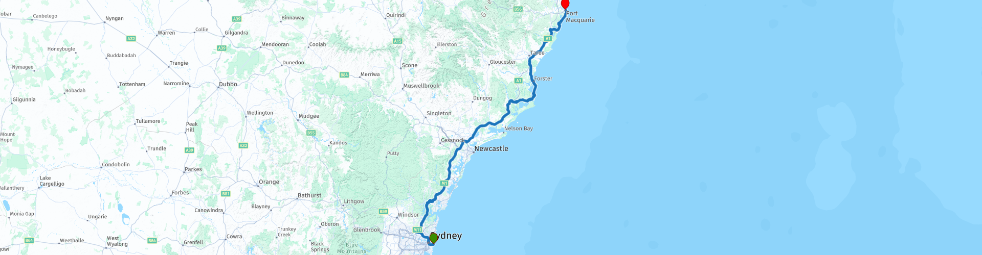
 You leave Sydney via the Pacific Motorway Sydney - Newcastle, this M1 Pacific Motorway, also known by the former names F3 Freeway, Sydney - Newcastle Freeway and Sydney - Newcastle Expressway; is a 127 km highway that connects Sydney with the Central Coast, Newcastle and Hunter regions of New South Wales. It is part of the AusLink pathway between Sydney and Brisbane. After an hour it is time to visit the Old Pacific Highway, this is a nice curvy part of a small 20 Km through Mooney Mooney Creek. Mooney Mooney Creek is a suburb of the Central Coast region of New South Wales, 60 kilometers north of Sydney along both sides of the river it is named after. It is part of the local government area of the Central Coast Council. Then you take the Pacific Motorway again up to Newcastle. Newcastle, an industrial town 167 km north of Sydney at the mouth of the Hunter River. The city had 288,732 inhabitants in the 2006 census, making it the 8th city in the country. You do not enter Newcastle, but you go onto the Pacific Highway, to leave it again after 4 KM, because in the Hunter Region Botanic Gardens, a coffee / lunch stop is planned and you can also take some nice pictures in the garden . The award-winning Hunter Region Botanic Gardens is managed and maintained by volunteers, and is used, among other things, for the enjoyment and education of people in the Hunter region and visitors from Australia and abroad. Then again a small 80 KM Pacific Highway to drive along the Lakes Way along the Myall Lakes, these are a series of freshwater lakes protected by the Ramsar convention. These are located in the Mid-Coast Council local government area in the Mid North Coast region of New South Wales. The Myall lakes border the east coast, about 250 kilometers north of Sydney.
After about 160 km you leave the Lakes Way and turn onto the Pacific Highway again. At Kew, you leave the Pacific Highway, it is then just under 50 KM to the end point in Port Macquarie, where you can relive this more or less Highway route in the hotel's swimming pool.
This 4-star rated route is mainly about beautiful highways, with occasional trips through nature reserves and a few small towns where you can stop for a snack.
General info:
New South Wales is a state of Australia with Sydney as its capital, and is often abbreviated to NSW. The three most important cities are, from north to south, Newcastle, Sydney and Wollongong, which are all on the coast. Other cities are Albury, Broken Hill, Dubbo, Tamworth, Armidale, Lismore, Nowra and Coffs Harbor.
The state is located on the east coast of the continent, north of the state of Victoria and south of the state of Queensland. In the west it borders South Australia. The coast borders the Tasman Sea. New South Wales has two federal enclaves: the Australian Capital Territory (ACT) and the Jervis Bay Territory.
New South Wales can be physically divided into four parts:
A narrow coastal strip, with a climate whose temperature varies from temperate on the extreme south coast to subtropical on the Queensland border.
The mountainous areas of the Greater Australian Separation Mountains and the highlands that surround it, such as the Southern Highlands, Central Tablelands and the regions of New England. Even though the mountain walls are not very steep, many mountain tops exceed 1000 meters, of which Mount Kosciuszko reaches 2229 meters as the highest peak.
The agricultural plains, which make up a large part of the area of the state. These areas are much less densely populated than the coast. This part includes the Riverina region.
The dry, desert-like plains in the far north-west of the state, which are unsuitable for settlements of any size.
It is the oldest colony of the former Australian colonies of the United Kingdom. The colony was founded in 1788 and originally included much more of the Australian mainland. At that time, the western half of the colony was called New Holland and the eastern half was New South Wales. New Holland was controlled from Sydney.
During the nineteenth century large areas were separated around the British colonies Van Diemen's Land (Tasmania) (1825), Victoria (1851), Queensland (1859) and South Australia (1836) (which at that time also included the Northern Territory) to shape. These colonies and Western Australia voted in 1901 to continue together as the Commonwealth of Australia.
Tourist attractions in the state include; The Blue Mountains, west of Sydney, a national park including the Three Sisters rock formation; The Hunter Valley, 150 km north of Sydney, the oldest wine region in Australia. The Snowy Mountains, on the border with Victoria, a popular ski resort, and the capital, Sydney.


 Links
Links  Usage
Usage Want to download this route?
You can download the route for free without MyRoute-app account. To do so, open the route and click 'save as'. Want to edit this route?
No problem, start by opening the route. Follow the tutorial and create your personal MyRoute-app account. After registration, your trial starts automatically.  Disclaimer
Use of this GPS route is at your own expense and risk. The route has been carefully composed and checked by a MyRoute-app accredited RouteXpert for use on TomTom, Garmin and MyRoute-app Navigation.
Changes may nevertheless have occurred due to changed circumstances, road diversions or seasonal closures. We therefore recommend checking each route before use.
Preferably use the route track in your navigation system. More information about the use of MyRoute-app can be found on the website under 'Community' or 'Academy'.