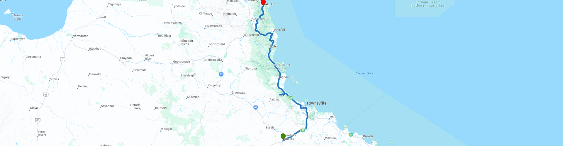
R12 QLD Charters Towers to Cairns

This route was brought to you by:
RouteXpert Hans van de Ven (Mr.MRA)
Last edit: 19-12-2020
 Route Summary
 Australia is very large; 8 million km2, which is more than 226 times larger than the Netherlands! Has a diversity of flora and fauna; the most diverse types of plants, trees and animals, especially birds and a lot of typical Australian marsupials, which you will not find anywhere else in the world!
Enjoy all the beauty immensely: From the evergreen tropical rainforests, to the vast Outback; from the desert to the countless and peaceful idyllic palm beaches; from the winter sports areas in the southeast to the vibrant and impressive metropolis of Melbourne, Sydney and Perth.
You will see it all and experience it in this amazing tour through Australia, a tour to remember!
Starting point: Charters Towers, Cattlemans Rest Motor Inn
End point: Cairns, Novotel
The route has been created for TomTom, Garmin and MyRoute-app Navigation users.
ATTENTION: DRIVE LEFT!
 Share this route


Animation

Verdict


Duration
8h 20m

Mode of travel
Car or motorcycle

Distance
599.50 km

Countries

 RouteXpert Review
 Reason enough to stay in Cairns for a few days and also explore this area.
Immediately after departure you have the opportunity to do some shopping and, if your tank and any jerry can are not full, refuel them. Via the Flinders Highway, this is a beautiful 2-lane road with a tight road surface, you go to Townsville, this piece is +/- 125 KM long, so a piece to continue driving and enjoy the view along the way.
Townsville is a coastal city in central Queensland about 1110 km northwest of Brisbane. With a population of approximately 120,000, Townsville is one of the larger cities in Australia. Townsville is at an elevation of approximately 16 feet. The nearest most populous place is the Brisbane metropolis, 1100 km away with a population of about 1.5 million people.
Nice opportunity to stop here for a drink. You can do this at the "Bohle Barn", just before turning onto the Bruce Highway.
After driving approximately 190 KM, stop along the Bruce Highway to refuel before turning off to Paluma Range National Park to get to the Star Valley Lookout point. About 80 miles north of Townsville, there is a left sign pointing to Paluma Range National Park. A quick look at the map shows a windy road to the middle of nowhere, so you could drive past it like this, but this is an area of great natural beauty not to be missed.
Paluma Range National Park is known as the 'southern gateway' to the Wet Tropics World Heritage Area. This is the southernmost patch of rainforest in Australia and a favorite escape from the tropical heat for Townsville residents. It is definitely worth a stop, so have a picnic and enjoy this rainforest environment. Make sure to bring your camera, walking shoes and swimsuits on a hot day.
Here are 4 things to see and do in Paluma National Park:
1. Swim
2. Bushwalk
3. Camping
4. Stay overnight
There are a handful of accommodation options in Paluma, including the award-winning eco resort in Hidden Valley Cabins. Surrounded by lush rainforest and Australian bushland, the resort offers daily tours and nighttime safaris. And of course you can also have lunch here !.
After lunch continue towards Ingham located on the Ingham, this is a medium sized city for Australia. Here is also an opportunity to refuel and to visit a McDonalds. Then you put on Cardwell and Tully. In Tylly also an opportunity to refuel. Via the Wooroonooran national park, (Aboriginal - "Black Rock"), is a national park between Innisfail and Cairns. The park is one of the national parks of the Wet Tropics World Heritage Area and is a World Heritage site. The World Heritage Area, declared in 1988, stretches from Townsville in the south to Cooktown in the north and contains some of the oldest surviving rainforests in the world. The national park covers most of Bellenden Ker Range and includes Queensland's two highest mountains, Mount Bartle Frere (1622 m) and Mount Bellenden Ker (1592 m). The Walshs Pyramid, at 922m, is just south of Gordonvale and is one of the tallest free-standing natural pyramids in the world. It also includes the parts of Australia that receive the most rain on average per year. The park consists of two parts: the Palmerston and the Josephine section. Both the north and south branches of the Johnstone River flow through the Palmerston section. Again good roads and bends galore.
After the National Park it is a short distance to the end point in Cairns. An Eagle Rider facility is located in Cairns. Just in front of the hotel you can refuel again and then enjoy the beauty that Cairns has to offer, as indicated earlier, the Great Barrier Reef.
This 4-star rated route mainly involves beautiful through roads. You pass through nature reserves and some nice places, where you can stop for a snack or to refuel.
General info:
Queensland (literally translated: Queensland) is a state in northeastern Australia. Queensland is the second largest in area and Australia's third largest state in terms of population. The state was named after Queen Victoria, the monarch at the time of the settlement of the former colony. The capital and largest city of Queensland is Brisbane, located in the southeast of the state. The northern portion of the state, separated by the Tropic of Capricorn, is tropical. The south is subtropical. Queensland was originally a British crown colony that emerged in 1859 after secession from New South Wales. The city of Brisbane originally started out as the Moreton Bay penal colony, which held convicts who again committed errors while serving their sentences in New South Wales.
Brisbane is located about 100 kilometers north of the border between Queensland and New South Wales. Southeast Queensland also has two larger population centers: the Gold Coast south of Brisbane, and the Sunshine Coast north of Brisbane. Along the approx. 2000 km long coast (from south to north) are the following cities: Coolangatta - Gold Coast - Brisbane - Sunshine Coast - Gympie - Maryborough - Hervey Bay - Bundaberg - Gladstone - Rockhampton - Mackay - Townsville - Cairns. The following cities are inland (counterclockwise): Warwick - Toowoomba - Roma - Charters Towers - Mount Isa. The world's largest city by surface, Mount Isa is located in northwestern Queensland. The surface of the city is 42,904 km² (about the surface of the Netherlands!), But the city has a population of approximately 20,000 (2003).
The state is home to five World Heritage Sites: Australian Mammal Fossil Sites (Riversleigh / Naracoorte),
Gondwana rainforests, Fraser Island, The Great Barrier Reef and the Tropical wetlands of Queensland.
Queensland can be roughly divided into three parts:
1.The eastern coastal strip, dominated by the Great Australian Separation Mountains. From north to south there are also the Darling Downs, the Bunya Mountains, the Carnarvon Gorge, the Whitsunday Islands, Hinchinbrook Island and the Atherton Tableland. Off the coast, north of Fraser Island, the Great Barrier Reef begins.
2.The tropical Cape York Peninsula in the north. To the north of this is the Straits Torres with the Straits Torres Islands and to the east most of the Great Barrier Reef.
3 Most of the dry interior, called the Queensland outback, with the Channel Country in the southwest.


 Links
Links  Usage
Usage Want to download this route?
You can download the route for free without MyRoute-app account. To do so, open the route and click 'save as'. Want to edit this route?
No problem, start by opening the route. Follow the tutorial and create your personal MyRoute-app account. After registration, your trial starts automatically.  Disclaimer
Use of this GPS route is at your own expense and risk. The route has been carefully composed and checked by a MyRoute-app accredited RouteXpert for use on TomTom, Garmin and MyRoute-app Navigation.
Changes may nevertheless have occurred due to changed circumstances, road diversions or seasonal closures. We therefore recommend checking each route before use.
Preferably use the route track in your navigation system. More information about the use of MyRoute-app can be found on the website under 'Community' or 'Academy'.