R48 SA VIC Adelaide to Ouyen

This route was brought to you by:
RouteXpert Hans van de Ven (Mr.MRA)
Last edit: 02-01-2021
 Route Summary
 Australia is very big; 8 million km2, that is more than 226 times larger than the Netherlands! Has a diversity of flora and fauna; the most diverse types of plants, trees and animals, especially birds and a lot of typical Australian marsupials, which you will not find anywhere else in the world!
Enjoy all the beauty enormously: From the evergreen tropical rainforests, to the vast Outback; from the desert to the countless and quiet idyllic palm beaches; from the winter sports areas in the south-east to the vibrant and impressive metropolis of Melbourne, Sydney and Perth.
You will see and experience it all in this great tour of Australia, a tour to remember!
Starting Point: Adelaide, Adelaide Inn
End point: Ouyen, Victoria Hotel
The route is made equal for TomTom, Garmin and MyRoute-app Navigation users.
NOTE: DRIVE LEFT!
 Share this route


Animation

Verdict


Duration
4h 30m

Mode of travel
Car or motorcycle

Distance
394.74 km

Countries

 RouteXpert Review
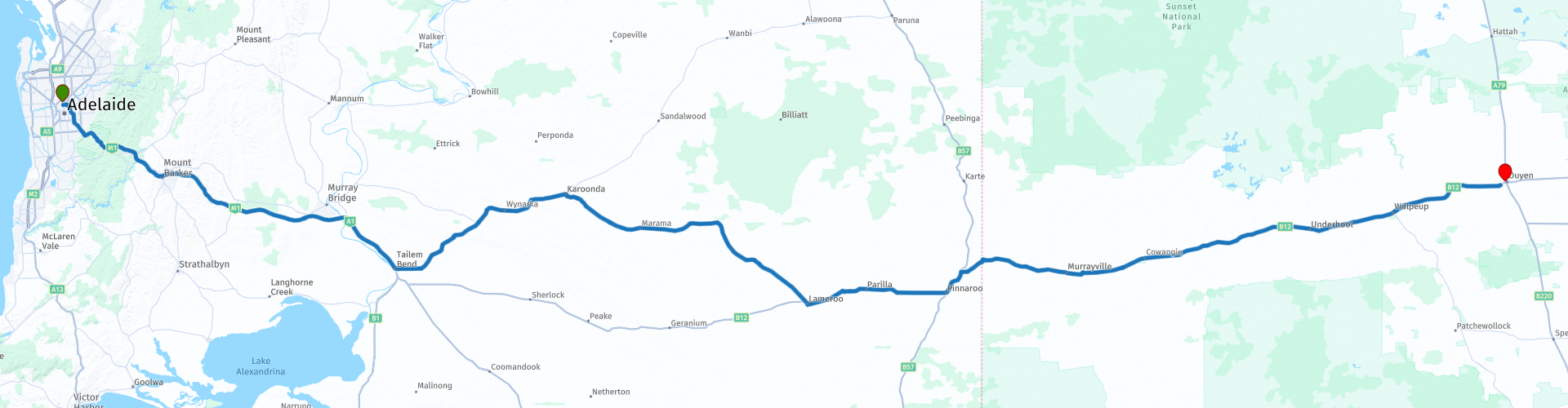
 The next stop is in the town of Pinnaroo, you are then about 6 KM from the border with the state of Victoria. Via the Mallee Highway, which is almost a straight line, you will pass the towns of Murrayville, Underbool, Walpeup and finally Ouyen.
This 4-star rated route has very good roads, through hills, and some nice little places where you can meet the locals.
General info:
South Australia (English: South Australia) is a state with an area of 983,482 km² it is the third largest state in the country. About one eighth of South Australia is occupied by the Woomera Prohibited Area military test site.
Many names in and around this state refer to Matthew Flinders and Nicolas Baudin. These explorers had been sent by England and France respectively to explore the south coast of Australia and claim the land. South Australia is Australia's driest state and much of it is arid and desert-like. The eastern portion of the Great Victoria Desert is in this state. In the northeast are the infamous Simpson Desert and the Tirari Desert. About 50% of the national wine production takes place in this state. Most winegrowers can be found in the southeast of the state on the border with Victoria.
The first recorded European sighting of the South Australian coast was in 1627 when the Dutch ship Gulden Zeepaert, commanded by François Thijssen, surveyed and mapped part of the coastline as far as the Nuyts archipelago. The land that now forms the state of South Australia was claimed for Great Britain in 1788 as part of the colony of New South Wales. Unlike the rest of Australia, terra nullius did not apply to the new province. The Letters Patent, which used the enabling provisions of the South Australia Act 1834 to establish the boundaries of the province of South Australia, provided that "nothing in our Letters Patent affects or can be construed as a influence on the rights of an Aboriginal In spite of a strong reference to the rights of the indigenous people in the first proclamation by the governor, there were many conflicts and deaths in the Australian border wars in South Australia. on December 28, 1836, now known as Proclamation Day.
South Australia is the only Australian state that has never received British convicts. In early 1838, settlers began to worry after it was reported that convicts who had escaped from the Eastern states could go to South Australia. The South Australia Police was formed in April 1838 to protect the community and enforce government regulations. Their main role was to run the first temporary prison, a two-room cabin.
The current flag of South Australia was adopted on January 13, 1904 and is a UK blue flag that is illegible with the state badge. The emblem is described as a piping shrike with wings outstretched on a yellow disk. The state badge is believed to have been designed by Robert Craig of Adelaide's School of Design.


 Links
Links  Usage
Usage Want to download this route?
You can download the route for free without MyRoute-app account. To do so, open the route and click 'save as'. Want to edit this route?
No problem, start by opening the route. Follow the tutorial and create your personal MyRoute-app account. After registration, your trial starts automatically.  Disclaimer
Use of this GPS route is at your own expense and risk. The route has been carefully composed and checked by a MyRoute-app accredited RouteXpert for use on TomTom, Garmin and MyRoute-app Navigation.
Changes may nevertheless have occurred due to changed circumstances, road diversions or seasonal closures. We therefore recommend checking each route before use.
Preferably use the route track in your navigation system. More information about the use of MyRoute-app can be found on the website under 'Community' or 'Academy'.