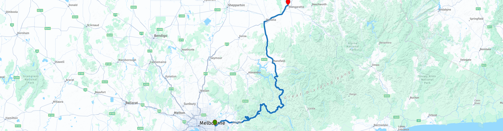
R01 VIC Melbourne to Wangaratta

This route was brought to you by:
RouteXpert Hans van de Ven (Mr.MRA)
Last edit: 16-05-2021
 Route Summary
 Australia is very big; 8 million km2, which is more than 226 times larger than the Netherlands! Has a diversity of flora and fauna; the most diverse types of plants, trees and animals, especially birds and a lot of typical Australian marsupials, that you won't find anywhere else in the world!
Enormous enjoyment of all the beautiful things: From the always green tropical rain forests to the vast Outback; from the desert to the countless and tranquil idyllic palm beaches; from the winter sports areas in the southeast to the bustling and impressive millions of cities of Melbourne, Sydney and Perth.
You will see and experience it all in this great tour through Australia, a tour you will never forget!
Starting point: Melbourne, Quality Hotel Manor.
End point: Wangaratta, Parkview Motor Inn
The route has been made the same for TomTom, Garmin and MyRoute-app Navigation users.
ATTENTION: LEFT DRIVING!
 Share this route


Animation

Verdict


Duration
7h 27m

Mode of travel
Car or motorcycle

Distance
390.30 km

Countries

 RouteXpert Review
 Melbourne is the capital of the Australian state of Victoria, founded in 1835 by a group of settlers from Tasmania. In 1842 the settlement became a city. Melbourne is the second largest city in Australia and the second largest in Oceania, apart from Sydney.
You leave the city via the Maroondah Highway, you can stop at a supermarket en route to take something to eat and drink on the way so that you could stop for a picnic on one of the many picnic places along the way. After an hour's drive, it's time for coffee and to fill up the tank, the next option is to refuel after 250 KM. You are now in the Yarra Rangers National Park, the Yarra Ranges National Park is part of an Aboriginal cultural landscape in the traditional Land of the Wurundjeri community.
The Yarra Ranges National Park is located between Melbourne and the Victorian Alps, a majestic rainforest landscape.
The Yarra Ranges extend over a vast, mountainous area of cool temperate forest around the three cities of Marysville, Healesville and Warburton. This national park is home to the world's tallest flowering tree, the Mountain Ash, which towers over lush tree ferns and mossy Myrtle Beech. Dark channels are home to clear streams that feed the Yarra River and large reservoirs from which Melbourne draws its drinking water. The Yarra Ranges has some beautiful lookouts, one of the best being Mount Donna Buang. From here you can see a great view of Westernport Bay and Port Phillip - or walk through the Rainforest Gallery and view the Mountain Ash from a different perspective. In winter, Mount Donna Buang is the closest winter playground in Melbourne. Many Melburnians have seen snow here for the first time over the years.
Then continue to the Upper Yarra Dam. The Upper Yarra Reservoir is located east of Melbourne, past Warburton in the town of Reefton. Water from Upper Yarra Reservoir supplies cities in the Upper Yarra Valley and Silvan Reservoir, which transfers water to most parts of Melbourne. And you can take a picture of the McVeigh's Water Wheel. The Waterwheel is a central and iconic monument of Warburton. Before 1908, this 4.3-meter-long wheel was used to power a generator for electrical lighting in the Contention gold mine in Contention Gully, about 10 kilometers south of the Upper Yarra Dam.
The swing really starts from here, because there is no shortage of curves. Please note that large parts are "Gravel Road", this is also indicated on time via a yellow sign along the road!
After about 200 KM you can stop in Woods Point at the Commercial Hotel to have something to eat and drink and to take a picture of a "Historic Petrol Station", you should do it while it is still there. After 250 km, in the town of Jamieson there is a possibility to refuel, but also to eat and drink something in the Jamieson General Store. From Jamieson you go in more or less a straight line through the Reef Hills State Park, this is a protected area of 2013 hectares, about 5 km southwest of Benalla, in the northeast of Victoria. There are traces of a gold fever mining activity. It was founded in 1986, to Banalla, where you also have 4 options for refueling. From Banella it is a little less than 5 KM to the end point of this route, Wangaratta.
Wangaratta is a city in the state of Victoria in Australia. The city has more than 16,000 inhabitants and is located 249 kilometers northeast of the capital of Victoria, Melbourne. The city lies on the Ovens and the King, which come from the Australian Alps.
This route, rated with 4 stars, is mainly about beautiful roads, through beautiful nature reserves and occasionally over gravel roads.
General info:
Victoria is the smallest state on the Australian mainland. It is located in the southeastern corner of the continent and has a population of over 6.5 million inhabitants on an area of 227,416 km². The border with New South Wales is the southern bank of the Murray River. In the west it borders South Australia and in the south the Indian Ocean. The Bass Street is located between Victoria and Tasmania. Just like Queensland, Victoria is named after Queen Victoria.
The area was already inhabited when the first Anglo-Australians settled there in 1803. In 1835 John Batman bought an area from the indigenous population on which the city of Melbourne was to be built. In 1851 the area was detached from New South Wales, and in 1855 it gained the status of a self-governing colony. A parliament was chosen, consisting of two chambers. The first prime minister was William Haines. In 1901 the six Australian colonies formed the Commonwealth of Australia, and since then Victoria has been a state of that country. The capital Melbourne with around 70% of the state's population and located on the north side of Port Philip Bay has Australia's busiest container port. The city is the economic and cultural center of the state. The State Library of Victoria is also located in this city.
There are huge differences in climate in Victoria, from the moderately humid eastern Gippsland to the winter-covered and almost 2000-meter-high Australian Alps in the north-east in the winter and from the hot semi-desert of the north-west to the lush irrigation areas along the Murray. Mount Bogong is the highest mountain in Victoria. In Victoria, gold was found at the Raspberry Creek in the 19th century. This gold was of very high quality. Hamlets were founded along the stream. The hamlet of A1 Mine Settlement owes its name to this period.


 Links
Links  Usage
Usage Want to download this route?
You can download the route for free without MyRoute-app account. To do so, open the route and click 'save as'. Want to edit this route?
No problem, start by opening the route. Follow the tutorial and create your personal MyRoute-app account. After registration, your trial starts automatically.  Disclaimer
Use of this GPS route is at your own expense and risk. The route has been carefully composed and checked by a MyRoute-app accredited RouteXpert for use on TomTom, Garmin and MyRoute-app Navigation.
Changes may nevertheless have occurred due to changed circumstances, road diversions or seasonal closures. We therefore recommend checking each route before use.
Preferably use the route track in your navigation system. More information about the use of MyRoute-app can be found on the website under 'Community' or 'Academy'.

Victoria
About this region
Victoria (abbreviated as Vic) is a state in southeastern Australia. It is the second-smallest state with a land area of 227,444 km2 (87,817 sq mi) and the most densely populated state in Australia (28 per km2). Victoria is bordered with New South Wales to the north and South Australia to the west, and is bounded by the Bass Strait to the south (with the exception of a small land border with Tasmania located along Boundary Islet), the Great Australian Bight portion of the Southern Ocean to the southwest, and the Tasman Sea (a marginal sea of the South Pacific Ocean) to the southeast. The state encompasses a range of climates and geographical features from its temperate coastal and central regions to the Victorian Alps in the north-east and the semi-arid north-west.
Victoria has a population of over 6.6 million, the majority of which is concentrated in the central south area surrounding Port Phillip Bay, and in particular in the metropolitan area of Greater Melbourne, Victoria's state capital and largest city and also Australia's second-largest city, where over three quarters of the Victorian population live. The state is home to four of Australia's 20 largest cities: Melbourne, Geelong, Ballarat and Bendigo. The population is diverse, with 35.1% of inhabitants being immigrants.Victoria is home to numerous Aboriginal groups, including the Boonwurrung, the Bratauolung, the Djadjawurrung, the Gunai, the Gunditjmara, the Taungurong, the Wathaurong, the Wurundjeri, and the Yorta Yorta. There were more than 30 Aboriginal languages spoken in the area prior to European colonisation. In 1770 James Cook claimed the east coast of the Australian continent for the Kingdom of Great Britain, and from 1788 the area that is now Victoria was a part of the colony of New South Wales. The first European settlement in the area occurred in 1803 at Sullivan Bay. Much of what is now Victoria was included in 1836 in the Port Phillip District of New South Wales. Named in honour of Queen Victoria, Victoria was separated from New South Wales and established as a separate Crown colony in 1851, achieving responsible government in 1855. The Victorian gold rush in the 1850s and 1860s significantly increased Victoria's population and wealth. By the time of Australian Federation in 1901, Melbourne had become the largest city in Australasia, and served as the federal capital of Australia until Canberra was opened in 1927. The state continued to grow strongly through various periods of the 20th and early 21st centuries as a result of high levels of international and interstate migration.
Victoria has 38 seats in the Australian House of Representatives and 12 seats in the Australian Senate. At state level, the Parliament of Victoria consists of the Legislative Assembly and the Legislative Council. The Labor Party, led by Daniel Andrews as premier, has governed Victoria since 2014. The Governor of Victoria, the representative of the Monarchy of Australia in the state, is currently Linda Dessau. Victoria is divided into 79 local government areas, as well as several unincorporated areas which the state administers directly.
Victoria's economy is the second-largest among Australian states and is highly diversified, with service sectors predominating. Culturally, Melbourne hosts a number of museums, art galleries, and theatres, and is also described as the world's sporting capital, and the spiritual home of Australian cricket and Australian rules football.
Read more on Wikipedia
Victoria has a population of over 6.6 million, the majority of which is concentrated in the central south area surrounding Port Phillip Bay, and in particular in the metropolitan area of Greater Melbourne, Victoria's state capital and largest city and also Australia's second-largest city, where over three quarters of the Victorian population live. The state is home to four of Australia's 20 largest cities: Melbourne, Geelong, Ballarat and Bendigo. The population is diverse, with 35.1% of inhabitants being immigrants.Victoria is home to numerous Aboriginal groups, including the Boonwurrung, the Bratauolung, the Djadjawurrung, the Gunai, the Gunditjmara, the Taungurong, the Wathaurong, the Wurundjeri, and the Yorta Yorta. There were more than 30 Aboriginal languages spoken in the area prior to European colonisation. In 1770 James Cook claimed the east coast of the Australian continent for the Kingdom of Great Britain, and from 1788 the area that is now Victoria was a part of the colony of New South Wales. The first European settlement in the area occurred in 1803 at Sullivan Bay. Much of what is now Victoria was included in 1836 in the Port Phillip District of New South Wales. Named in honour of Queen Victoria, Victoria was separated from New South Wales and established as a separate Crown colony in 1851, achieving responsible government in 1855. The Victorian gold rush in the 1850s and 1860s significantly increased Victoria's population and wealth. By the time of Australian Federation in 1901, Melbourne had become the largest city in Australasia, and served as the federal capital of Australia until Canberra was opened in 1927. The state continued to grow strongly through various periods of the 20th and early 21st centuries as a result of high levels of international and interstate migration.
Victoria has 38 seats in the Australian House of Representatives and 12 seats in the Australian Senate. At state level, the Parliament of Victoria consists of the Legislative Assembly and the Legislative Council. The Labor Party, led by Daniel Andrews as premier, has governed Victoria since 2014. The Governor of Victoria, the representative of the Monarchy of Australia in the state, is currently Linda Dessau. Victoria is divided into 79 local government areas, as well as several unincorporated areas which the state administers directly.
Victoria's economy is the second-largest among Australian states and is highly diversified, with service sectors predominating. Culturally, Melbourne hosts a number of museums, art galleries, and theatres, and is also described as the world's sporting capital, and the spiritual home of Australian cricket and Australian rules football.
View region
 Statistics
  9
9Amount of RX reviews (Victoria)
 12383
12383Amount of visitors (Victoria)
 380
380Amount of downloads (Victoria)
 Route Collections in this region
 Top Car and Motorcycle Route from Melbourne to Brisbane
Planning to go through Australia by motorcycle? Then read the five tips below carefully, so that you can start your motorcycle holiday well prepared. Good preparation is half the job.
1. Decide in advance where you want to rent your motorcycle. Find a reliable rental company with good reviews. By comparing the prices of various rental companies, you can save a lot of money.
2. Plan your routes in advance. Australia is so big that it is useful to know in advance exactly where you want to go.
3. In Australia you don't just get from A to B: you have to drive a long time to get to your next destination. Practicing long motorcycle riding is therefore definitely recommended.
4. Always check the weather forecast. You can't take much on the bike, so only bring what you really need according to the weather forecast.
5. Are you going in high season? Book your accommodations in advance. If you plan to go camping, invest in a good tent.
Motorbike rental:
AussieRider : https://www.aussierider.com/bikes/australie/#
EagleRider : https://www.eaglerider.com/motorverhuur/australia
General:
Toll roads:
Toll roads are ideal for getting around or through a huge city like Sydney, Melbourne or Brisbane quickly and very easy to use. There are no toll booths, so it is not possible to pay on site. The toll must be paid by yourself by telephone and credit card within three days after using the road or tunnel. When you pick up the rental motorcycle, you will receive all the information about this. It's a simple system but it requires action from yourself to avoid fines.
Motorbike traffic rules:
Motorcycling rules in Australia vary by state or territory. Inquire about the regulations on site.
Helmet:
Wearing a helmet is mandatory for driver and passenger. The helmet must comply with the Australian Standard (AS/NZS1698) or the European Standard (UNECE 22.05), which is indicated on a decal or label inside the helmet. In some states, such as New South Wales and Victoria, a helmet may no longer meet the standard if a small camera is mounted on it, if speakers (Bluetooth) are built in, or if the helmet has a tinted visor.
Lighting: Dipped beam is not mandatory during the day, but is recommended.
Passengers:
The carriage of 1 passenger is allowed. Children under 8 years of age are not allowed to be transported on the motorbike. Children from 8 years old may only be transported on the back if they can reach the footrests with their feet. Younger children may be transported in a sidecar. In several states, such as New South Wales, Northern Territory and Queensland, it is only allowed to carry a passenger if the driver has held a motorcycle license for more than one year.
Driving side by side:
Two motorcycles may ride side by side, provided that their mutual distance does not exceed 1.5 m.
traffic jams:
In Australia it is allowed to slalom between stationary or slow-moving cars in a traffic jam (lane filtering) provided a maximum speed of 30 km/h is maintained and other traffic is not endangered.
gas stations:
In Australia, a gas station is often referred to as servo (derived from service station). In the outback, a gas station is often called a road house. Pay attention; The number of filling stations is very limited, especially along the southern main route and the north-south connections. Keep this in mind and take enough spare fuel with you. For example, use the Fuel Map Australia app (fuelmap.com.au) to search for nearby gas stations and see current fuel prices.
Opening hours:
Gas stations are usually open at least from 8 a.m. to 6 p.m. or 8 p.m. Many gas stations in larger towns and along highways offer 24-hour service or have gas dispensers. When planning longer trips, keep in mind that outside the major towns and along minor roads, gas stations are not open at night or in the morning, and sometimes on Sundays.
Pay:
Cash can be paid at petrol stations. Credit cards are accepted at most gas stations.
Tank machines:
Major credit cards are usually accepted at fuel dispensers (pay-at-the-pump), but often require a PIN to be used.
Reserve fuel:
Because the distances between places in Australia are long and gas stations in the outback may not always have sufficient fuel in stock, it is recommended that you always carry a spare tank of fuel. It is prohibited to carry fuel in a reserve tank on ferries.
View Route Collection
The 10 most downloaded routes in Australia from RouteXpert Hans van de Ven
Hello and welcome to this collection of the Top 10 MyRoute app downloaded routes in Australia.
There will be a great new event to be announced soon, where all these routes can be driven.
Download them all now and place them in a new "Top 10" folder, so that you always have them at hand.
If you are going to drive one of these routes in the meantime, track them with the MRA Mobile App or with MRA Navigation. Take some photos (moments) along the way as these will come in handy.
Create a travelogue of your Top 10 driven routes and add the recorded track to it.
There will also be some great prizes on offer, so keep an eye on the MRA-RouteXperts page and your mail.
The 10 routes are:
1. R06 NSW Jenolan to Sydney
2. R04 NSW Jenolan Roundtrip Blue Mountains North West
3. R02 VIC NSW Wangaratta to Canberra
4. R05 NSW Jenolan Roundtrip Blue Mountains East
5. R23 NT Darwin to Willeroo
6. R54 Williamstown to Melbourne
7. R47 SA Roundtrip Adelaide South
8. R35 WA Perth to Mount Barker
9. R19 NT Tennant Creek to Mataranka
10. R10 QLD Chinchilla to Springsure
View Route Collection