Fortified Cities from Conde sur Lescaut

This route was brought to you by:
RouteXpert Jan Koelstra - Senior Rx
Last edit: 01-05-2025
 Route Summary
 In addition to admiring these fortifications, attention is also paid to the fortified towns and villages themselves as well as the general sights. The most important military fortifications of both world wars are also mentioned along the route.
The route is rated five stars because of the alternation between the vastness of the landscape, the pleasant, sometimes surprising roads on the one hand and the ingenious constructions of the fortified towns and forts on the other.
 Share this route


Animation

Verdict


Duration
8h 32m

Mode of travel
Car or motorcycle

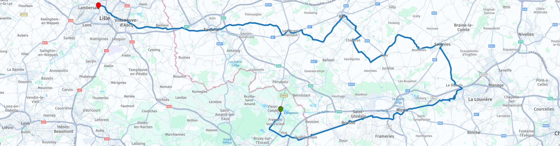
Distance
167.08 km

Countries


 RouteXpert Review
 The claims of Louis XIV of France on Flanders resulted in five French occupations between 1646 and 1706 and the construction of fortifications as well as the construction of the citadel of Kortrijk. During the wars of Louis XIV of France it became clear that the Spanish Empire was no longer able to defend the Southern Netherlands. If the Southern Netherlands were lost, France would become a threat to the Republic and to the balance of power in Europe.
You start this trip in the fortified town of Condé. During the Revolution, the name was changed to "Nord-Libre" by order of the authorities. Finally, in 1886, the town was given its current name: Condé-sur-l'Escaut. Over time, the town has experienced a lot. It was successively taken and reconquered by the Franks, the Nordic barbarians, the Flemish of Jacques Van Artevelde and the French king Louis XI. From 1556, it came under Spanish rule, after which it was besieged by Louis XIV in 1676 and definitively annexed by France. Thanks to the Peace of Nijmegen in 1678, it became definitively French. In the past, it was considered a stronghold, but in 1901 it lost this status and in 1923 it was dismantled. The town remained a mining town until 1989, the year the Fosse Ledoux was finally closed, although it provided the main source of employment for men.
The city has three other castles on its territory: the Hermitage Castle, which is privately owned, the Bailleul Castle, which is owned by the city, and finally the Arsenal Castle, an archaeological site. Two churches, including the Saint-Wasnon Church, which is listed as Historical Monuments, and the Macou Church, are also part of the city's religious heritage. Its mining past is also remarkable, with its slag heaps and winding tower, all of which are on the UNESCO World Heritage List.
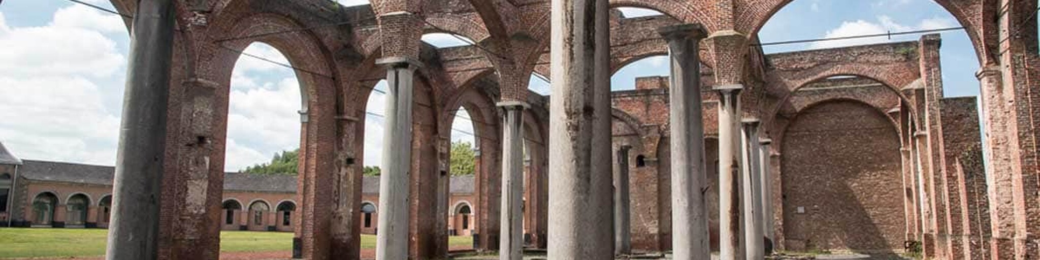
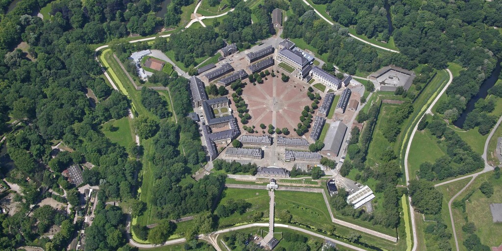
On the way to Belgium you pass a petrol station near the village of Fresnes. Past the border town of Quiévrain, whose fortifications have completely disappeared, you continue through the Borinage region towards Mons/Bergen. Just before Mons you will find the historic industrial mining complex Le Grand-Hornu. The site is an important example of industrial heritage from the industrial revolution and an early example of functional urban planning at the beginning of the 19th century. Henri De Gorge (12 February 1774 - 22 August 1832) built the city district, the workshops, the offices and the owner's house "Kasteel De Gorge" between 1810 and 1830. The neoclassical style uses arched vaults, triangular gables and semi-circular windows.
Around 1650, Mons/Bergen also began a long, miserable period in which the violence of war regularly slowed down the economic recovery. On 8 April 1691, Philip Francis of Glymes had to surrender the city to the French troops (80,000 strong) after a siege of nine months. King Louis XIV had come down in person on 15 March to attend the military operations. The French artillery had caused a lot of damage all over the city. Mons remained a French possession until 1697, after which it came alternately into Austrian and French hands. The French were in charge from 1701 to 1709, and then from 1746 to 1749. Because the military operations of the 18th century caused so much damage, the city was mainly rebuilt in that period, which is why the current cityscape is largely 18th century. In the late 17th century and the first half of the 18th century, Bergen was one of the fortified towns that formed part of the Dutch fortification barrier in the Southern Netherlands.
Fortunately, some of the former urban beauty can still be found. The Collégiale Sainte-Waudru in Brabantine Gothic was built between 1450 and 1686. The Belfry was built in 1662 on the substructure of the destroyed Castle of the Counts, which was the residence of the Counts of Hainaut from the 9th to the 15th century. The belfry tower is the only Belgian belfry in Baroque style. Of the Castle of the Counts itself, the Conciergerie and the Romanesque Saint-Calixtus Chapel (1051) have been preserved.
The beautiful buildings of the Grand-Place form a worthy setting for the City Hall of Mons. In the 17th century, a side wing was added on the left and right and in 1718 it got its bell tower. To the left of the entrance is the popular monkey, the Singe du Grand Garde, a statue that is said to bring good luck to whoever strokes its head. Maybe do it after coffee?
The castle of Havré, beyond Mons, where you can see the Canal du Centre, is now a ruined castle. The castle is surrounded by a moat and consists of a large courtyard, four corner towers, of which the dungeon is covered with a spherical dome, and a Gothic chapel. The castle was built around 1226 by counts from Flanders and Hainaut. The castle was restored in 1978 by the non-profit organisation Les Amis du Château des Ducs d'Havré (The Friends of the Castle of Havré). Today, the castle is used for weddings and events. In 2000, a large rose garden with 15,000 rose bushes was created.
The Centrumkanaal was dug in the second half of the 19th century. The coal mines of Hainaut were flourishing but there was a strong need to connect the rivers Sambre and Scheldt. The biggest problem with the construction of the canal was a height difference of 66 metres over a distance of six kilometres between Houdeng-Goegnies and Thieu. This required 17 locks. This would lead to two major disadvantages, the locking of ships takes a lot of time and a lot of water is lost with each lock operation.
Four hydraulic ship lifts were built on the Centrumkanaal between 1888 and 1917 and together they bridge a drop of about 68 metres. One lift bridges 15.4 metres and the other three each 16.93 metres. In 1998, the four lifts were added to the UNESCO World Heritage List.
Since 2002, these structures have only been used for pleasure craft. Freight transport has since been diverted via the large Strépy-Thieu boat lift, which bridges the 73.15 metre drop in one go.
The origins of the city of Soignies/Zinnik lie in the foundation, around 650, of an abbey by Vincentius Madelgarius, a nobleman from the entourage of King Dagobert I. At the end of his life he retired to his estate. He founded the abbey there, where he also died and was buried. The city of Soignies would later grow around this abbey. Madelgarius was canonized as Saint Vincent. Zinnik only became a real city in the 14th century, through the development of a cloth industry and the construction of a fortress wall (after 1365). From the 17th century onwards, the mining of blue limestone, called petit granit, developed. These are the main sights: the église Saint-Vincent is one of the most beautiful examples of Romanesque architecture in Belgium. The choir and the transept date from the end of the 10th century, beginning of the 11th century. The west tower (already Gothic) is from around 1250. The church has a richly decorated interior. Close to the church is also the Cloth Hall from the 16th century.
In the 11th century, the small town of Chièvres belonged to the Lordship of Chièvres of the powerful Van Egmont family. During their reign, a castle ensemble was built on the site where the Tour de Gavre now stands. Because of its important administrative and military centre, Chièvres was surrounded by a city wall before 1186, remains of which are still visible today. It experienced an intense boom in industrial and economic activity towards the end of the 14th century, but was ultimately unable to cope with the competition from neighbouring Ath. Around 1560, Charles of Croÿ had a traditional seigniorial manor house built on the Grand Place. Although they did not move in, the Van Egmont family had this manor house extended with a traditional wing around 1700. The building now serves as a retirement home and was extended in 2009 with a large rear wing. The Tour de Gavre from the 15th century still exists from the medieval defence belt. The Gothic Église Saint-Martin from the 14th century was provided in the 16th century with a beautiful bell tower with corner turrets, typical of Hainaut Gothic. There is also a city pump from 1853.
Ath/Aat is located on the Dender. The city was fortified several times, including by Charles V and Vauban. The terraces are packed and the various shops in the area are just as successful. Many come here to shop. And then we haven't even mentioned the historical treasures, such as the Burbant Tower. This fortified tower was built in 1166 and is listed as Walloon heritage. The city developed around this imposing military fortification. Other sights include the St. Julien Church, the St. Martin Church and the town hall. There is undoubtedly still a spot left here for lunch.
The small town of Leuze-en-Hainaut is not to be missed, because this old town has a lot to offer, such as the Église Saint-Pierre with its fortified tower, the hospital chapel of Saint-John of God, a brick church with stylistic features of Art Deco and Neo-Gothic, and the Mahymobiles automobile museum.
In June 1667, the army of the French king Louis XIV conquered the city of Tournai/Doornik from the army of the Southern Netherlands, after a siege of two days. The outdated English citadel in the north of the city was dismantled (with the exception of the Tower of Henry VIII) and the French built a new citadel in the south on a hill. Only the foundations of the citadel, built according to plans by architect Deshoulières, have been preserved. Furthermore, the city walls were provided with bastions. By canalizing the Scheldt, an inundation system could be built around the city walls. In 1709, during the War of the Spanish Succession, the city was besieged by the army of the Duke of Marlborough and the citadel was taken after a siege of 58 days.
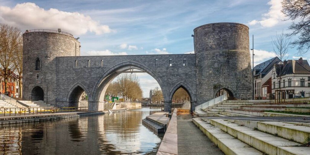
Tournai is still considered one of the most important monument cities in Belgium. Of great importance is the Romanesque Cathedral of Our Lady. There is a 13th century bridge 'Pont des Trous' over the Scheldt, the oldest belfry in Belgium and a cloth hall, both on the interesting Grote Markt, and furthermore various city gates and warehouses.
Then follows the last part of your journey, across the border to Lille/Rijsel. The old city of Lille is now part of an enormous ring of residential and working districts and extends with its buildings onto Belgian territory. The commercial city had already been fortified five times when the military architect Vauban enriched Lille with an important citadel. Only the exterior of this citadel can be visited, including the Porte Royale, a classical complex that was created during the reign of the Sun King. A zoo with a tropical pavilion and green jogging paths surround the military 'star'. Not far from the international train station Lille-Europe, a monastery has been converted into a gunners' museum. During the Spanish period, Lille received a magnificent stock exchange and in the old centre many more buildings bear witness to the wealth that Lille amassed. Many donations from wealthy merchants and noblemen have ended up in the Museum of Fine Arts on the Place de la République. After the Louvre in Paris, it is the largest French art museum. You can admire masterpieces by Flemish masters, among others, in a beautiful setting.
 Links
Links  Usage
Usage Want to download this route?
You can download the route for free without MyRoute-app account. To do so, open the route and click 'save as'. Want to edit this route?
No problem, start by opening the route. Follow the tutorial and create your personal MyRoute-app account. After registration, your trial starts automatically.  Disclaimer
Use of this GPS route is at your own expense and risk. The route has been carefully composed and checked by a MyRoute-app accredited RouteXpert for use on TomTom, Garmin and MyRoute-app Navigation.
Changes may nevertheless have occurred due to changed circumstances, road diversions or seasonal closures. We therefore recommend checking each route before use.
Preferably use the route track in your navigation system. More information about the use of MyRoute-app can be found on the website under 'Community' or 'Academy'.

Hauts de France
About this region
Hauts-de-France (French pronunciation: [o də fʁɑ̃s] (listen); Picard: Heuts-d'Franche; lit. 'Heights of France') is the northernmost region of France, created by the territorial reform of French regions in 2014, from a merger of Nord-Pas-de-Calais and Picardy. Its prefecture is Lille. The new region came into existence on 1 January 2016, after regional elections in December 2015. The Conseil d'État approved Hauts-de-France as the name of the region on 28 September 2016, effective the following 30 September.With 6,009,976 inhabitants (as of 1 January 2015) and a population density of 189 inhabitants/km2, it is the third most populous region in France and the second most densely populated in metropolitan France after its southern neighbour Île-de-France. It is bordered by Belgium to the north.
Read more on Wikipedia
View region
 Statistics
  38
38Amount of RX reviews (Hauts de France)
 34110
34110Amount of visitors (Hauts de France)
 2652
2652Amount of downloads (Hauts de France)
 Route Collections in this region
 24 Magnificent trails in France
It is clear that France is one of the most beautiful and best touring countries. It offers an incredibly varied landscape with good roads and a pleasant climate. It is not for nothing that you see so many motorcyclists there. My previous collection of 25 routes in France (25 Magnificent routes in France) were based on the route descriptions from the Motortourgids France part 1 made by Bert Loorbach.
This collection of 24 routes comes from Motortourgids France part 2. In this collection, a difference has been made between approach routes and motorcycle tours in a certain area. The approach routes can also be used in combination with the routes from Motortourgids France part 1
The routes are sometimes slightly adjusted based on the tips that Bert Loorbach gives in his description, or because of another place to spend the night, or to reach the minimum length of 2 hours for the MRA Library. For each route, the review contains a more detailed description, including options to stay overnight or places of interest along the way, which are also indicated with a POI and if possible with a short description.
Two or more routes have been created for a number of areas, such as for Burgundy, Auvergne, The Alps, Tarn and Cévennes and Nord-Pas de Calais. These routes can be nicely combined in a multi-day trip.
View Route Collection
The 10 most downloaded routes in France from RouteXpert Catherine De Groote
Hello and welcome to this collection of the Top 10 MyRoute app downloaded routes in France.
A great new event will be announced soon, where all of these routes can be driven.
Download them all now and place them in a new "Top 10" folder so that you always have them at hand.
If you are going to drive one of these routes in the meantime, track them with the MRA Mobile App or with MRA Navigation. Take some photos (moments) along the way as they will come in handy.
Create a travelogue of your Top 10 driven routes and add the recorded track to it.
There will also be some great prizes on offer, so keep an eye on the MRA-RouteXperts page and your email.
View Route Collection