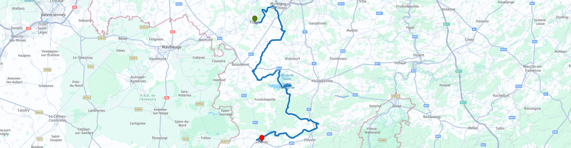
Hainault Boot South Trip from Thuin

This route was brought to you by:
RouteXpert Jan Koelstra - Senior Rx
Last edit: 30-11-2024
 Route Summary
 At the top of the boot, the shaft, are the beautiful towns of Lobbes and Thuin with their centuries-old remains of abbeys.
In the instep the pretty village of Barbençon, one of the 'Most Beautiful Villages of Wallonia'. There you will discover a private castle, a remnant of the medieval fortification and the Lacs de l'Eau d'Heure, lakes that form the largest water area in Belgium. The La Plate Taille dam is the largest in Belgium, with its 100-metre-high panorama tower.
At the bottom it already smells of the Ardennes with the princely town of Chimay. Don't forget to taste the local Trappist beer and the fragrant cheeses.
But the greatest attraction of the Boot of Hainaut is the numerous immense forests, through which run high-quality roads, the Walloon villages with their characteristic blue stone, the babbling mountain streams, and the many reservoirs. Then a five-star rating is inevitable.
 Share this route


Animation

Verdict


Duration
8h 2m

Mode of travel
Car or motorcycle

Distance
102.98 km

Countries

 RouteXpert Review
 Your tour starts in Thuin, an old city that has played an important strategic role since the 7th century. The high and dry location on the Sambre river is less important today and Thuin is a bit sleepy but has preserved much from earlier times, especially in the old upper town that towers high above the Sambre. The belfry (1638) was once a church tower, but Thuin is also fascinating because of the many old houses that have a heavy and solid character. Part of the old ramparts have also been preserved. Just outside the town there is a beautiful view of Thuin and its so-called "hanging gardens". Just outside Thuin there is an opportunity to refuel.
From there it is a short distance to the abbey ruins of Aulne. This abbey was founded in the 7th century, had its heyday in the 18th century and was completely destroyed in 1794, during the French Revolution. What remains are monumental ruins, which suddenly appear before you. The ruins of the Gothic church are particularly magnificent. Also interesting is the abbey farm, a remarkable 18th century building. The abbey is open every day from 9 am to 8 pm. The locks on the Sambre in the vicinity of the abbey of Aulne are very picturesque.
Via Ham you drive back over Barbençon, another one of the most beautiful villages in Wallonia. It was known for its glass and marble activities. One of the most typical streets, the Rue des Marbriers (street of the marble workers), bears witness to this. Together with the church and the presbytery, it forms the historical heart of Barbençon. The characteristic houses made of limestone rubble are real heritage gems. The church of Saint-Lambert in Gothic and Renaissance style was restored in the 1970s. Its interior is a reminder of the rich past of Barbençon: tombs of the great glass and marble masters, high altar, baptismal font and of course also visit the castle of Barbençon at the lake of the same name.
A little further on begins the reservoir complex of l'Eau D'Heure: The reservoirs are a concept in the water sports world. The Belgian Jet-ski championships take place here and surfing is also possible, while a sandy beach has also been constructed. The reservoirs are among the largest in the country. The dam of La Plate Taille can be visited both internally and externally.
You will now take a trip to the former fortified town of Mariembourg, which was built in 1546 by Mary of Hungary, sister of Charles V and governor of the Netherlands. It was located opposite the fortress of Maubert-Fontaine, which was located on French territory. The star-shaped geometric layout of the town was preserved, but the moats and fortifications disappeared in 1853.
Just outside the town lies the brewery 'Brasserie des Fagnes', where beers have been produced for almost a century and a half. Here, the visitor enters a temple of Belgian beer. Master brewer Luc Piron offers a whole range of 'Brassins Spéciaux' (Special Brews), with surprising flavours: beer with nettle, with heather flower, with organic honey...
If you suddenly want something different: step into an authentic steam train and travel back in time, during a ride through the 'Three Valleys' along unimaginable landscapes. After leaving Mariembourg, the train travels to Nismes, Olloy/Viroin and Vierves until Treignes, the last station before the French border.
Via the Aquascoop nature reserve near the Virelles lake, you will pass the old Chimay motor circuit, where you can view the starting tower, and arrive in the princely city of Chimay via a contemporary women's abbey.
Famous for its Trappist beers and cheeses, Chimay was elevated to a principality in 1486. Its castle, ramparts, ancient staircases, paved streets and cramped houses are reminders of the history of this thousand-year-old city nestled in the boot of Hainaut.


 Links
Links  Usage
Usage Want to download this route?
You can download the route for free without MyRoute-app account. To do so, open the route and click 'save as'. Want to edit this route?
No problem, start by opening the route. Follow the tutorial and create your personal MyRoute-app account. After registration, your trial starts automatically.  Disclaimer
Use of this GPS route is at your own expense and risk. The route has been carefully composed and checked by a MyRoute-app accredited RouteXpert for use on TomTom, Garmin and MyRoute-app Navigation.
Changes may nevertheless have occurred due to changed circumstances, road diversions or seasonal closures. We therefore recommend checking each route before use.
Preferably use the route track in your navigation system. More information about the use of MyRoute-app can be found on the website under 'Community' or 'Academy'.

Wallonia
About this region
The Walloon Region (French: Région wallonne [ʁeʒjɔ̃ walɔn]; German: Wallonische Region; Dutch: Waals gewest), usually simply referred to as Wallonia (; French: Wallonie [walɔni]; Walloon: Waloneye; German: Wallonien [vaˈloːni̯ən] (listen) or Wallonie [valoˈniː]; Dutch: Wallonië [ʋɑˈloːnijə] (listen)), is one of the three Regions of Belgium—alongside the Flemish Region and the Brussels-Capital Region.Covering the southern portion of the country, Wallonia is primarily French-speaking, and accounts for 55% of Belgium's territory, but only a third of its population. The Walloon Region was not merged with the French Community of Belgium, which is the political entity responsible for matters related mainly to culture and education, because the French Community of Belgium encompasses both Wallonia and the bilingual Brussels-Capital Region.
There is a German-speaking minority in eastern Wallonia, resulting from the annexation of three cantons previously part of the German Empire at the conclusion of World War I. This community represents less than 1% of the Belgian population. It forms the German-speaking Community of Belgium, which has its own government and parliament for culture-related issues.
During the industrial revolution, Wallonia was second only to the United Kingdom in industrialization, capitalizing on its extensive deposits of coal and iron. This brought the region wealth, and from the beginning of the 19th to the middle of the 20th century, Wallonia was the more prosperous half of Belgium. Since World War II, the importance of heavy industry has greatly diminished, and the Flemish Region has exceeded Wallonia in wealth as Wallonia has declined economically. Wallonia now suffers from high unemployment and has a significantly lower GDP per capita than Flanders. The economic inequalities and linguistic divide between the two are major sources of political conflicts in Belgium and a major factor in Flemish separatism.
The capital of Wallonia is Namur, and the most populous city is Charleroi. Most of Wallonia's major cities and two-thirds of its population lie along the east-west aligned Sambre and Meuse valley, the former industrial backbone of Belgium. To the north of this valley, Wallonia lies on the Central Belgian Plateau, which, like Flanders, is a relatively flat and agriculturally fertile area. The south and southeast of Wallonia is made up of the Ardennes, an expanse of forested highland that is less densely populated.
Wallonia borders Flanders and the Netherlands (the province of Limburg) in the north, France (Grand Est and Hauts-de-France) to the south and west, and Germany (North Rhine-Westphalia and Rhineland-Palatinate) and Luxembourg (Capellen, Clervaux, Esch-sur-Alzette, Redange and Wiltz) to the east. Wallonia has been a member of the Organisation Internationale de la Francophonie since 1980.
Read more on Wikipedia
There is a German-speaking minority in eastern Wallonia, resulting from the annexation of three cantons previously part of the German Empire at the conclusion of World War I. This community represents less than 1% of the Belgian population. It forms the German-speaking Community of Belgium, which has its own government and parliament for culture-related issues.
During the industrial revolution, Wallonia was second only to the United Kingdom in industrialization, capitalizing on its extensive deposits of coal and iron. This brought the region wealth, and from the beginning of the 19th to the middle of the 20th century, Wallonia was the more prosperous half of Belgium. Since World War II, the importance of heavy industry has greatly diminished, and the Flemish Region has exceeded Wallonia in wealth as Wallonia has declined economically. Wallonia now suffers from high unemployment and has a significantly lower GDP per capita than Flanders. The economic inequalities and linguistic divide between the two are major sources of political conflicts in Belgium and a major factor in Flemish separatism.
The capital of Wallonia is Namur, and the most populous city is Charleroi. Most of Wallonia's major cities and two-thirds of its population lie along the east-west aligned Sambre and Meuse valley, the former industrial backbone of Belgium. To the north of this valley, Wallonia lies on the Central Belgian Plateau, which, like Flanders, is a relatively flat and agriculturally fertile area. The south and southeast of Wallonia is made up of the Ardennes, an expanse of forested highland that is less densely populated.
Wallonia borders Flanders and the Netherlands (the province of Limburg) in the north, France (Grand Est and Hauts-de-France) to the south and west, and Germany (North Rhine-Westphalia and Rhineland-Palatinate) and Luxembourg (Capellen, Clervaux, Esch-sur-Alzette, Redange and Wiltz) to the east. Wallonia has been a member of the Organisation Internationale de la Francophonie since 1980.
View region
 Statistics
  105
105Amount of RX reviews (Wallonia)
 32569
32569Amount of visitors (Wallonia)
 26131
26131Amount of downloads (Wallonia)
 Route Collections in this region
 The 10 most beautiful car and motorcycle routes in Limburg
Limburg, who thinks of Limburg, thinks of flan, coal mines, marl and the hill country. The coal mines have been closed for almost 40 years, the last load of coal was brought up from the Oranje-Nassau coal mine in Heerlen on 31 December and, as they say, South Limburg was transformed from Black to Green and unfortunately there is still little left. view of this period.
But not only pie, marl and coal in Limburg, but also a very beautiful province to tour by car or motorcycle and enjoy all the beauty that the province of Limburg has to offer. For this, the MyRoute app RouteXpert has put together a Top 10 of Car and Motorcycle routes for you.
All routes in this collection have been checked and made equal for TomTom, Garmin and MyRoute-app Navigation by a MyRoute-app RouteXpert.
If you think, I have a very nice route that should certainly not be missing from this collection, send it to:
email: routeexpert@myrouteapp.com
Subject: New Route for the Top 10 collection Province of Limburg composed by Hans van de Ven.
The route will then be reviewed and then added to the Top 10.
To make the Top 10 also the Top 10, 1 route will have to disappear from the Top 10, you can indicate this when submitting the new route.
Have fun with this collection and while driving one of these routes. Enjoy all the beauty that the Netherlands and in particular the province of Limburg has to offer. Click on “View route” to read the review of the chosen route.
I would like to hear your findings about the route(s).
View Route Collection
Top 5 Car and Motorcycle Routes in the Eifel
The Eifel is the eastern part of the medium plateau Eifel-Ardennes. It is located north of the Moselle and west of the Rhine. The largest part is in Germany, a small part is in Belgium, in the East Cantons. The German part of Eifel is located in the federal states of North Rhine-Westphalia and Rhineland-Palatinate. The highest point is the Hohe Acht with 747 meters.
Several chains can be distinguished in the Eifel:
The northernmost part is called the Nordeifel, which in Belgium connects to the High Fens;
To the east of this is the Ahrgebirge, this part is located north of the Ahr in the Ahrweiler district;
South of the Ahr is the Hohe Eifel (or Hocheifel), of which the Hohe Acht (747 m) is the highest point, and also the highest point in the entire Eifel region;
To the west, near the Belgian border, the hills are known as Schneifel, part of the wider Snow Eifel area with peaks reaching up to 698 metres;
South and east of the Hohe Eifel is the Volcano-Eifel, a volcanic area with many crater lakes (Maare).
The southern part of the Eifel is less high. The area is bisected by streams and rivers running southwards. These streams flow into the Moselle. The largest of these rivers is the Kyll; the hills around this river are known as the Kyllwald;
In the south, the Eifel ends in the Voreifel.
In the north of the Eifel there are some large reservoirs. The largest of these is the reservoir in the Roer that was created by the construction of the Roerdal dam.
The Nürburgring is also located in the Eifel, a well-known car circuit for Formula 1 races, among other things. Since 2004, part of the north of the Eifel has become the Eifel National Park. This National Park falls entirely within the German-Belgian nature park High Fens-Eifel. Another part of the Eifel falls within the South Eifel Nature Park.
Well-known throughout the Netherlands and Belgium by car and motorcyclists, so reason enough for the MyRoute app RouteXpert to compile a Top 5 of Car and Motorbike routes for you.
All routes in this collection have been checked and made equal for TomTom, Garmin and MyRoute-app Navigation by a MyRoute-app RouteXpert.
If you think, I have a very nice route that should certainly not be missing from this collection, send it to:
email: routeexpert@myrouteapp.com
Subject: New Route for the Top 5 collection Eifel composed by Hans van de Ven.
The route will then be reviewed and then added to the Top 5. To make the Top 5 also the Top 5, 1 route will have to disappear from the Top 5, you can indicate this when submitting the new route.
Have fun with this collection and while driving one of these routes. Enjoy all the beauty that the Eifel has to offer. Click on “View route” to read the review of the chosen route.
I would like to hear your findings about the route(s).
View Route Collection