Rondrit Luik via Remouchamps Ambleve en Huy

This route was brought to you by:
RouteXpert Guy Heyns - Adv. RouteXpert
Last edit: 10-12-2024
 Route Summary
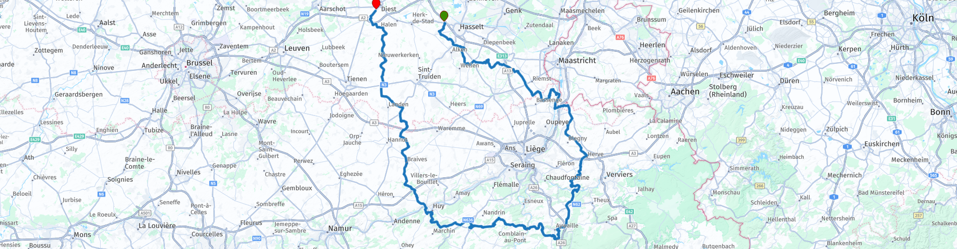
 The tour around 'big' Liège starts in Kuringen near Hasselt, ends in Diest and covers a whole range of roads while the route leads you along some nice sights. For example, you pass the Castle of Alden Biesen and the fort of Eben Emael, while the villages of Huy and Remouchamps also slide under your wheels.
The height profile of this tour can also be called varied, at the very least, as evidenced by some vicious 'pins' which, together with a sometimes 'challenging' road surface, require the necessary attention and concentration from the hopefully average experienced driver.
 Share this route


Animation

Verdict


Duration
5h 59m

Mode of travel
Car or motorcycle

Distance
239.57 km

Countries


 RouteXpert Review
 The starting point of the route is again easy to find and is located near the highway E313 which you can use as a approach route. The large car park offers shopping and restaurant options, including breakfast. There is no petrol station and the first petrol pump (marked on the route at route point 31) is immediately 91 km away on the route.
Soon after departure you drive on rural roads through some typical Limburg villages. Good road surface, pleasant curves, short, long and very varied. Then you drive between the houses and immediately be surprised by wonderful views or richly filled fruit orchards.
The first straight on the route leads you directly to Alden Biesen Castle (route point 8). Please look for more information in the attached link. Many events are organized here and it can therefore be really busy at certain times.
You drive around the castle to end up on an elongated strip between the fields. The temptation will be great to challenge the throttle. Be careful here…, not only because of the hikers & bikers, but also because of the right-wing priority…. The road surface is generally very good, though, but your tires could choke on patches of loam soil left by the farmers on the road surface.
Between route points 11 and 12 you cross the very busy Tongersesteenweg, but from then on it becomes ... pure enjoyment ... The route starts to show its beauty and versatility extensively from here and with every meter you drive you can feel the pleasure of riding a motorbike. The nice thing about this route is that it continues to offer this to you until the last meter.
Between points 13 and 14 you enter the Walloon part of the country and you will notice this by the quality of the road, especially if you drive the route just after the winter season. The really bad pieces have already been removed from the route, but vigilance remains warranted.
At route point 17 you can, if desired, make time to visit the Fort van Eben Emael. More information can be found in the attached links, but the story of this - built entirely in the mountain - fort is to say the least. The guns of the Fort fired one shot. Only then as a test. And the Germans needed only one bomb to take out the entire fort. Bizarre… and a blot on the Belgian military system…
After this point the first two pins present themselves. Just before the second, when you leave the plateau, you will find a beautiful viewpoint near route point 19. Many people stop here to enjoy the view, but the parking options here are very limited. You can only park on the edge of the road. However, if you drive in a duo or in a limited group, a small break is certainly possible. In clear weather, you can look at three countries at the same time and get an impression of the economic and military importance of the region. The presence of the typical loam soil and marl, the river Maas and the Albert canal have certainly contributed to this. Many a soldier, even from the Napoleonic era, has lost life here. Also remember that ancient Roman Tongeren, the oldest city in Belgium, is also not very far from here. Humanity was here early ...
After this possible short break you drive again through very varied area. After all, this route is about motorcycling itself. You will not really encounter many straights.
At route point 31 and after 91 km you will encounter the first petrol station on the route itself. Immediately afterwards, the bend festival starts, after which you arrive via some villages in Remouchamps where you can relax on the edge of the Amblève. If desired, you can visit the caves of Rémouchamps where you can experience the longest Belgian underground boat trip (600 meters).
As far as the route itself is concerned, even after Remouchamps the cornering festival continues until just past Comblain au Pont (route point 42). Here too you can take a break if it was too busy in Remouchamps, for example.
A seemingly elongated strip, mostly through very green terrain, leads you to the town of Huy on the edge of the Maas. Extensive tourist possibilities with the highlight being the 'fortress' at the top of the mountain. You can decide to drive straight at route point 49, which will take you to the center of Huy. Pay attention! limited parking options! However, the route itself remains on the outside of the town to continue the rest of the very varied route in the direction of Flanders.
Be vigilant on these field roads. Corners are sometimes cut too short - also by oncoming traffic - and right of way everywhere. Some local people actually take it, so surprises often occur ...
The Brussels-Liège motorway that you drive over actually marks the Flemish-Walloon border. You are now back in Flanders where the maximum speed is 70 km / h instead of 90 km / h on the Walloon roads. That will take some getting used to….
But take comfort, the roads and surroundings will certainly remain beautiful, and driving less quickly will allow you to enjoy the roads and the landscape even more during the last kilometers.
Finally, you will arrive at the Carrefour van Diest car park, where you can say goodbye, fill up and enjoy a quick snack. Incidentally, the city of Diest also offers you some pleasant tourist assets, so if you decide to stay here, you can.
The route seems easy, but it is actually quite technical. Of course you do not drive the high altitudes with this route, but therefore some pins or the road surface itself are no less challenging. The route requires - perhaps even more than other routes - permanent attention and concentration. Sometimes because of the road surface or its shape, but also because of the versatility and the varied course. Add to that a number of 'locals' who sometimes want to cut that one corner (where you just hang in) a bit too enthusiastic… and the sum is quickly made.
The route rating of four stars has its reason. It is definitely a top-3 route, but given the fact that the route had to be adapted due to the road quality, it does take away a bit of the honor. The absence of refueling options at the start of the route and pleasant relaxation options in the Walloon part of the country is another element that you should take into account. But driving the route itself by an average experienced rider is an absolute & true driving pleasure. And that is what this route is all about… She demands and offers more driving skills than perhaps any other route due to the almost complete absence of straight strips of road surface. That is precisely why it is best driven by experienced drivers. Beginners, especially towards the end, will catch their breath…


 Links
Links  Usage
Usage Want to download this route?
You can download the route for free without MyRoute-app account. To do so, open the route and click 'save as'. Want to edit this route?
No problem, start by opening the route. Follow the tutorial and create your personal MyRoute-app account. After registration, your trial starts automatically.  Disclaimer
Use of this GPS route is at your own expense and risk. The route has been carefully composed and checked by a MyRoute-app accredited RouteXpert for use on TomTom, Garmin and MyRoute-app Navigation.
Changes may nevertheless have occurred due to changed circumstances, road diversions or seasonal closures. We therefore recommend checking each route before use.
Preferably use the route track in your navigation system. More information about the use of MyRoute-app can be found on the website under 'Community' or 'Academy'.

Limburg
About this region
Limburg (Dutch pronunciation: [ˈlɪmbʏr(ə)x] (About this soundlisten)) is the southernmost of the 12 provinces of the Netherlands. The province is bordered by the province of Gelderland to the north and by North Brabant to its west. Its long eastern boundary forms the international border with the state of North Rhine-Westphalia in Germany. To the west is the international border with the similarly named Belgian province of Limburg, part of which is delineated by the river Meuse. The Vaalserberg is on the extreme south-eastern point, marking the tripoint of the Netherlands, Germany and Belgium.
Limburg's major cities are the provincial capital Maastricht (pop. 121,565[5]), as well as Venlo (pop. 101,603) in the Northeast, and Sittard-Geleen (pop. 92,661) and Heerlen (pop. 86,832) in the south. More than half of the population, approximately 650,000 people, live in the south of Limburg, which corresponds to roughly one-third of the province's area proper. In South Limburg, most people live in the urban agglomerations of Maastricht, Parkstad and Sittard-Geleen.
Read more on Wikipedia
Limburg's major cities are the provincial capital Maastricht (pop. 121,565[5]), as well as Venlo (pop. 101,603) in the Northeast, and Sittard-Geleen (pop. 92,661) and Heerlen (pop. 86,832) in the south. More than half of the population, approximately 650,000 people, live in the south of Limburg, which corresponds to roughly one-third of the province's area proper. In South Limburg, most people live in the urban agglomerations of Maastricht, Parkstad and Sittard-Geleen.
View region
 Statistics
  97
97Amount of RX reviews (Limburg)
 59219
59219Amount of visitors (Limburg)
 23353
23353Amount of downloads (Limburg)
 Route Collections in this region
 The 10 most beautiful car and motorcycle routes in North Brabant
Brabant, Brabant conviviality, bon vivants and who does not know the song by Guus Meeuwis about Brabant? "And then I think of Brabant, because there is still light burning there" and that is true, because the City of Light is in Brabant, in Eindhoven that is, but Eindhoven is also known as the match city of the Netherlands. The annual light festival (GLOW) in Eindhoven shows breathtaking lighting techniques, something you must see once.
But not only light, matches and Brabant cosiness in Brabant, but also a very beautiful province to tour by car or motorcycle and enjoy all the beauty that the province of Brabant has to offer. For this, the MyRoute app RouteXpert has put together a Top 10 of Car and Motorcycle routes for you.
All routes in this collection have been checked and made equal for TomTom, Garmin and MyRoute-app Navigation by a MyRoute-app RouteXpert.
If you think, I have a very nice route that should certainly not be missing from this collection, send it to:
email: routeexpert@myrouteapp.com
Subject: New Route for the Top 10 collection Province of Brabant composed by Hans van de Ven.
The route will then be reviewed and then added to the Top 10.
To make the Top 10 also the Top 10, 1 route will have to disappear from the Top 10, you can indicate this when submitting the new route.
Have fun with this collection and while driving one of these routes. Enjoy all the beauty that the Netherlands and in particular the province of Brabant has to offer. Click on “View route” to read the review of the chosen route.
I would like to hear your findings about the route(s).
View Route Collection
The 10 most beautiful car and motorcycle routes in Limburg
Limburg, who thinks of Limburg, thinks of flan, coal mines, marl and the hill country. The coal mines have been closed for almost 40 years, the last load of coal was brought up from the Oranje-Nassau coal mine in Heerlen on 31 December and, as they say, South Limburg was transformed from Black to Green and unfortunately there is still little left. view of this period.
But not only pie, marl and coal in Limburg, but also a very beautiful province to tour by car or motorcycle and enjoy all the beauty that the province of Limburg has to offer. For this, the MyRoute app RouteXpert has put together a Top 10 of Car and Motorcycle routes for you.
All routes in this collection have been checked and made equal for TomTom, Garmin and MyRoute-app Navigation by a MyRoute-app RouteXpert.
If you think, I have a very nice route that should certainly not be missing from this collection, send it to:
email: routeexpert@myrouteapp.com
Subject: New Route for the Top 10 collection Province of Limburg composed by Hans van de Ven.
The route will then be reviewed and then added to the Top 10.
To make the Top 10 also the Top 10, 1 route will have to disappear from the Top 10, you can indicate this when submitting the new route.
Have fun with this collection and while driving one of these routes. Enjoy all the beauty that the Netherlands and in particular the province of Limburg has to offer. Click on “View route” to read the review of the chosen route.
I would like to hear your findings about the route(s).
View Route Collection