Maastricht Bosfagne Ouren Gemund Maastricht

This route was brought to you by:
RouteXpert Hans van de Ven (Mr.MRA)
Last edit: 25-03-2021
 Route Summary
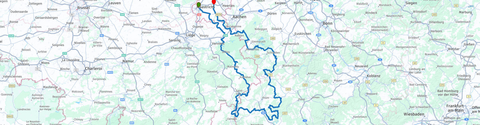
 Motorbike paradise Eifel is just a stone's throw from the Netherlands. You can enjoy curves, rolling landscapes, beautiful villages and romantic castles. You start in Maastricht, and drive south through towns like Slenaken, Heyenrath, Vaals and Moresnet.
 Share this route


Animation

Verdict


Duration
8h 29m

Mode of travel
Car or motorcycle

Distance
435.90 km

Countries


 RouteXpert Review
 The route starts at the McDonalds in Maastricht. We drive to the south where we quickly enter Belgium, via Sippenaeken we drive towards the "High Fens" * where we at Boulangerie Philippe Hennes a delicious sandwich and cup of coffee. Then on to the head of Luxembourg to stretch the legs at Hotel Rittersprung. Then the Eifel in and back to the Netherlands.
* The High Fens (German: Hohes Venn; French: Hautes Fagnes) are part of the High Fens-Eifel Nature Park. The High Fens are located on a plateau, largely in the Ardennes and for a smaller part in the Eifel. It is located in Wallonia in eastern Belgium, there in the province of Liège, and in a piece of adjacent Germany. The whole covers about 4500 ha. As the name implies, a large part of the region consists of deposits of high peat. Some of this is still active, which means that peat formation still occurs. The High Fens have been provided with the European diploma for nature management since 1966. (source: Wikipedia).
The Eifel is the eastern part of the middle plateau Eifel-Ardennes. It lies north of the Moselle and west of the Rhine. The largest part is in Germany, a small part is located in Belgium, in the East Cantons. The German part of Eifel lies in the states of North Rhine-Westphalia and Rhineland-Palatinate. The highest point is the Hohe Acht with 747 meters. In the Tertiary, there was strong volcanic activity in the Eifel. The name Vulkane-Eifel also refers to this in the southeastern part. The craters created by explosions of volcanic gases have filled themselves with groundwater and are called Maare. The last eruptions took place 10,000 years ago. Research shows that this area is still geologically active: the entire Eifel region rises 1 to 2 millimeters per year. In the past, inactive phases of 10,000 to 20,000 years have also occurred, suggesting that future eruptions are still possible. (Source: Wikipedia).
Dutch South Limburg is a region in the south of the Dutch province of Limburg. The area covers an area of 660 km² and has approximately 600,000 inhabitants. South Limburg is characterized by a varied relief and beautiful nature areas in the midst of highly urbanized areas. The most important cities are Maastricht, Heerlen, Sittard and Kerkrade. The area also forms the Safety Region South Limburg (a joint venture between municipalities, fire brigade and medical assistance) (Source: Wikipedia).
Because I have driven this route myself, this route gets 5 stars.
Route details:
The route is created for TomTom, Garmin and MyRoute-app Navigation users.
Take something to eat and drink along the way, then you can always stop to stretch the legs and what to eat and / or drink or to take some pictures.
rp 9 - Boulangerie Philippe Hennes (Coffee and a sandwich)
rp 16 - Hotel-Restaurant Rittersprung
rp 17 - Europa Monument
rp 26 - Photomoment
rp 34 - Gemünder Brauhaus (Schnitzels)
rp 40 - Haus Zahlepohl (Coffee)
rp 48 - Square view Climbing (Ice)


 Links
Links  Usage
Usage Want to download this route?
You can download the route for free without MyRoute-app account. To do so, open the route and click 'save as'. Want to edit this route?
No problem, start by opening the route. Follow the tutorial and create your personal MyRoute-app account. After registration, your trial starts automatically.  Disclaimer
Use of this GPS route is at your own expense and risk. The route has been carefully composed and checked by a MyRoute-app accredited RouteXpert for use on TomTom, Garmin and MyRoute-app Navigation.
Changes may nevertheless have occurred due to changed circumstances, road diversions or seasonal closures. We therefore recommend checking each route before use.
Preferably use the route track in your navigation system. More information about the use of MyRoute-app can be found on the website under 'Community' or 'Academy'.

Rheinland Pfalz
About this region
Rhineland-Palatinate (German: Rheinland-Pfalz, [ˈʁaɪ̯nlant ˈp͡falt͡s] (listen)) is a western state of Germany. It covers 19,846 km2 (7,663 sq mi) and has about 4.05 million residents. It is the ninth largest and sixth most populous of the sixteen states. Mainz is the capital and largest city. Other cities are Ludwigshafen am Rhein, Koblenz, Trier, Kaiserslautern and Worms. It is bordered by North Rhine-Westphalia, Saarland, Baden-Württemberg and Hesse and by the countries France, Luxembourg and Belgium.
Rhineland-Palatinate was established in 1946 after World War II, from parts of the former states of Prussia (part of its Rhineland province), Hesse and Bavaria (its former outlying Palatinate kreis or district), by the French military administration in Allied-occupied Germany. Rhineland-Palatinate became part of the Federal Republic of Germany in 1949 and shared the country's only border with the Saar Protectorate until the latter was returned to German control in 1957. Rhineland-Palatinate's natural and cultural heritage includes the extensive Palatinate winegrowing region, picturesque landscapes, and many castles and palaces.
Read more on Wikipedia
Rhineland-Palatinate was established in 1946 after World War II, from parts of the former states of Prussia (part of its Rhineland province), Hesse and Bavaria (its former outlying Palatinate kreis or district), by the French military administration in Allied-occupied Germany. Rhineland-Palatinate became part of the Federal Republic of Germany in 1949 and shared the country's only border with the Saar Protectorate until the latter was returned to German control in 1957. Rhineland-Palatinate's natural and cultural heritage includes the extensive Palatinate winegrowing region, picturesque landscapes, and many castles and palaces.
View region
 Statistics
  142
142Amount of RX reviews (Rheinland Pfalz)
 56166
56166Amount of visitors (Rheinland Pfalz)
 30049
30049Amount of downloads (Rheinland Pfalz)
 Route Collections in this region
 Top 5 Car and Motorcycle Routes in the Eifel
The Eifel is the eastern part of the medium plateau Eifel-Ardennes. It is located north of the Moselle and west of the Rhine. The largest part is in Germany, a small part is in Belgium, in the East Cantons. The German part of Eifel is located in the federal states of North Rhine-Westphalia and Rhineland-Palatinate. The highest point is the Hohe Acht with 747 meters.
Several chains can be distinguished in the Eifel:
The northernmost part is called the Nordeifel, which in Belgium connects to the High Fens;
To the east of this is the Ahrgebirge, this part is located north of the Ahr in the Ahrweiler district;
South of the Ahr is the Hohe Eifel (or Hocheifel), of which the Hohe Acht (747 m) is the highest point, and also the highest point in the entire Eifel region;
To the west, near the Belgian border, the hills are known as Schneifel, part of the wider Snow Eifel area with peaks reaching up to 698 metres;
South and east of the Hohe Eifel is the Volcano-Eifel, a volcanic area with many crater lakes (Maare).
The southern part of the Eifel is less high. The area is bisected by streams and rivers running southwards. These streams flow into the Moselle. The largest of these rivers is the Kyll; the hills around this river are known as the Kyllwald;
In the south, the Eifel ends in the Voreifel.
In the north of the Eifel there are some large reservoirs. The largest of these is the reservoir in the Roer that was created by the construction of the Roerdal dam.
The Nürburgring is also located in the Eifel, a well-known car circuit for Formula 1 races, among other things. Since 2004, part of the north of the Eifel has become the Eifel National Park. This National Park falls entirely within the German-Belgian nature park High Fens-Eifel. Another part of the Eifel falls within the South Eifel Nature Park.
Well-known throughout the Netherlands and Belgium by car and motorcyclists, so reason enough for the MyRoute app RouteXpert to compile a Top 5 of Car and Motorbike routes for you.
All routes in this collection have been checked and made equal for TomTom, Garmin and MyRoute-app Navigation by a MyRoute-app RouteXpert.
If you think, I have a very nice route that should certainly not be missing from this collection, send it to:
email: routeexpert@myrouteapp.com
Subject: New Route for the Top 5 collection Eifel composed by Hans van de Ven.
The route will then be reviewed and then added to the Top 5. To make the Top 5 also the Top 5, 1 route will have to disappear from the Top 5, you can indicate this when submitting the new route.
Have fun with this collection and while driving one of these routes. Enjoy all the beauty that the Eifel has to offer. Click on “View route” to read the review of the chosen route.
I would like to hear your findings about the route(s).
View Route Collection
Route collection hairpins in the Eifel
This collection is composed of the most beautiful and winding roads in the Eifel. Forget Bundesstraßen, forget the road along the Moselle, if you have driven these roads, you can really say that you have been to the Eifel.
No less than 6 routes and 1,800 kilometers are waiting for you!
No less than 6 routes and 1,800 kilometers are waiting for you!
View Route Collection