Zeilberg Bollendorf

This route was brought to you by:
RouteXpert Hans van de Ven (Mr.MRA)
Last edit: 03-03-2019
 Route Summary
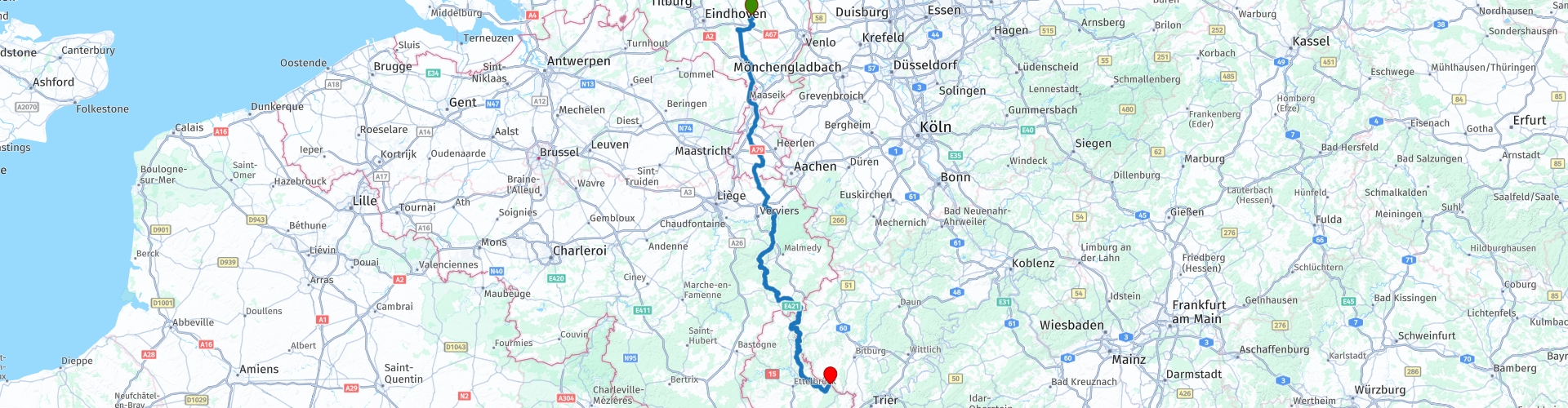
 Starting point: Café Zaal 't-Vertierke in Deurne (Zeilberg).
End point: Hotel Café Hauer in Bollendorf.
 Share this route


Animation

Verdict


Duration
6h 3m

Mode of travel
Car or motorcycle

Distance
295.52 km

Countries


 RouteXpert Review
 What we thought of the hotel at the time: https://www.mtczeilberg.nl/verslagen_details.phtml?id=3
After you have departed from Zeilberg, you drive inland to Klimmen, where the 1st (coffee) stop is planned at IJssalon Pleinzicht. In front of the ice cream parlor is a large parking lot where you can park the engine in sight.
After coffee we drive on and then stop at the American military cemetery Henri-Chapelle and Lac de la Gileppe to take some pictures.
---
The more than 20 hectares of the American military cemetery Henri-Chapelle are home to the remains of 7,992 American soldiers. Most of these men lost their lives during the advance of the American forces in Germany. The 1st American Infantry Division liberated this location on 11 September 1944. A provisional war cemetery was established on 28 September 1944.
Their tombstones are arranged in wide arches on an outstretched, sloping lawn. A road cuts through the cemetery. To the west of it, a viewpoint offers a beautiful view of the peaceful Belgian countryside that once was a battlefield. To the east there is a colonnade which forms the memorial together with the chapel and the visitors room. The chapel is simple, but richly decorated. The visitors' room contains two maps that give an insight into the military operations of the American army, engraved in black granite, with inscriptions referring to the victories of the American forces. On the rectangular pillars of the colonnade the names of 450 missing soldiers are engraved. Behind the names of the missing persons who have been found and identified, a rosette has been applied.
The cemetery contains the American dead of two major military campaigns: the campaign of the 1st American Army through Northern France, Belgium, the Netherlands and Luxembourg towards Germany (September 1944) and the Battle of the Bulge, the German counter-offensive in the Ardennes (December 1944 - January 1945).
From the temporary cemetery Henri-Chapelle the first repatriation of fallen American soldiers to the United States was organized for reburialization in their own country. The repatriation program began on 27 July 1947 with a special ceremony in Henri-Chapelle. The first ship with mortal remains left Antwerp in early October after an impressive ceremony attended by 30,000 Belgian citizens.
---
The Gileppestuwdam (French: barrage de la Gileppe) is a dam in the Belgian province of Liège. The supply of water is ensured by the Gileppe, which rises in the High Fens. The original wall was the oldest concrete dam wall in Europe. The complex was officially opened on 28 July 1878 by King Leopold II. The water absorption capacity of the reservoir was then 13 million m³, with an area of 86 ha. The original purpose of the dam was to provide usable water for the textile industry in the Verviers area.
In the period 1968-1971 the dam was raised by more than 10 m. Since then the capacity of the lake is 26.5 million m³ at an area of 130 ha. Together with the Vesder dam in Eupen, the lake now provides drinking water.
The most important feature of the dam is a 13.5 meter high and 300 ton lion from sandstone. The lion stands on top of the dam wall and was put down so that he looks proudly in the direction of the only 5 kilometers removed border with the then Prussia.
---
After taking the pictures it is time to have lunch, we do this at the Waterfalls of Coo, where you can park your motorcycle in sight. There is plenty of choice, so something for everyone.
After lunch we often swing on beautiful motorways towards Ouren where we stop at Hotel Rittersprong for coffee with some goodies. Again, the engines are beautiful in sight. We stop in Hosingen at Dosberbreck Sam's Lounge once more to stretch the legs and refuel. After the coffee again, the bridge (route point 61) is completely lost in July (we are so lucky) due to heavy rainfall. Just before the day we arrive at the end of this route, we first refuel when we are still in Luxembourg at the Q8, then we cross the Sauer and take a right. If you look at photo 3, you can see that the water in the Sauer is already very high.
We are at Hotel Hauer, where we stay for the Spring weekend.
See the video to get an impression of the surroundings, the images are occasionally unclear, but that is because of the rain that we have had along the way: https://www.youtube.com/watch?v=fWsDKEeDmzQ


 Usage
Usage Want to download this route?
You can download the route for free without MyRoute-app account. To do so, open the route and click 'save as'. Want to edit this route?
No problem, start by opening the route. Follow the tutorial and create your personal MyRoute-app account. After registration, your trial starts automatically.  Disclaimer
Use of this GPS route is at your own expense and risk. The route has been carefully composed and checked by a MyRoute-app accredited RouteXpert for use on TomTom, Garmin and MyRoute-app Navigation.
Changes may nevertheless have occurred due to changed circumstances, road diversions or seasonal closures. We therefore recommend checking each route before use.
Preferably use the route track in your navigation system. More information about the use of MyRoute-app can be found on the website under 'Community' or 'Academy'.

Rheinland Pfalz
About this region
Rhineland-Palatinate (German: Rheinland-Pfalz, [ˈʁaɪ̯nlant ˈp͡falt͡s] (listen)) is a western state of Germany. It covers 19,846 km2 (7,663 sq mi) and has about 4.05 million residents. It is the ninth largest and sixth most populous of the sixteen states. Mainz is the capital and largest city. Other cities are Ludwigshafen am Rhein, Koblenz, Trier, Kaiserslautern and Worms. It is bordered by North Rhine-Westphalia, Saarland, Baden-Württemberg and Hesse and by the countries France, Luxembourg and Belgium.
Rhineland-Palatinate was established in 1946 after World War II, from parts of the former states of Prussia (part of its Rhineland province), Hesse and Bavaria (its former outlying Palatinate kreis or district), by the French military administration in Allied-occupied Germany. Rhineland-Palatinate became part of the Federal Republic of Germany in 1949 and shared the country's only border with the Saar Protectorate until the latter was returned to German control in 1957. Rhineland-Palatinate's natural and cultural heritage includes the extensive Palatinate winegrowing region, picturesque landscapes, and many castles and palaces.
Read more on Wikipedia
Rhineland-Palatinate was established in 1946 after World War II, from parts of the former states of Prussia (part of its Rhineland province), Hesse and Bavaria (its former outlying Palatinate kreis or district), by the French military administration in Allied-occupied Germany. Rhineland-Palatinate became part of the Federal Republic of Germany in 1949 and shared the country's only border with the Saar Protectorate until the latter was returned to German control in 1957. Rhineland-Palatinate's natural and cultural heritage includes the extensive Palatinate winegrowing region, picturesque landscapes, and many castles and palaces.
View region
 Statistics
  135
135Amount of RX reviews (Rheinland Pfalz)
 43879
43879Amount of visitors (Rheinland Pfalz)
 26768
26768Amount of downloads (Rheinland Pfalz)
 Route Collections in this region
 Top 5 Car and Motorcycle Routes in the Eifel
The Eifel is the eastern part of the medium plateau Eifel-Ardennes. It is located north of the Moselle and west of the Rhine. The largest part is in Germany, a small part is in Belgium, in the East Cantons. The German part of Eifel is located in the federal states of North Rhine-Westphalia and Rhineland-Palatinate. The highest point is the Hohe Acht with 747 meters.
Several chains can be distinguished in the Eifel:
The northernmost part is called the Nordeifel, which in Belgium connects to the High Fens;
To the east of this is the Ahrgebirge, this part is located north of the Ahr in the Ahrweiler district;
South of the Ahr is the Hohe Eifel (or Hocheifel), of which the Hohe Acht (747 m) is the highest point, and also the highest point in the entire Eifel region;
To the west, near the Belgian border, the hills are known as Schneifel, part of the wider Snow Eifel area with peaks reaching up to 698 metres;
South and east of the Hohe Eifel is the Volcano-Eifel, a volcanic area with many crater lakes (Maare).
The southern part of the Eifel is less high. The area is bisected by streams and rivers running southwards. These streams flow into the Moselle. The largest of these rivers is the Kyll; the hills around this river are known as the Kyllwald;
In the south, the Eifel ends in the Voreifel.
In the north of the Eifel there are some large reservoirs. The largest of these is the reservoir in the Roer that was created by the construction of the Roerdal dam.
The Nürburgring is also located in the Eifel, a well-known car circuit for Formula 1 races, among other things. Since 2004, part of the north of the Eifel has become the Eifel National Park. This National Park falls entirely within the German-Belgian nature park High Fens-Eifel. Another part of the Eifel falls within the South Eifel Nature Park.
Well-known throughout the Netherlands and Belgium by car and motorcyclists, so reason enough for the MyRoute app RouteXpert to compile a Top 5 of Car and Motorbike routes for you.
All routes in this collection have been checked and made equal for TomTom, Garmin and MyRoute-app Navigation by a MyRoute-app RouteXpert.
If you think, I have a very nice route that should certainly not be missing from this collection, send it to:
email: routeexpert@myrouteapp.com
Subject: New Route for the Top 5 collection Eifel composed by Hans van de Ven.
The route will then be reviewed and then added to the Top 5. To make the Top 5 also the Top 5, 1 route will have to disappear from the Top 5, you can indicate this when submitting the new route.
Have fun with this collection and while driving one of these routes. Enjoy all the beauty that the Eifel has to offer. Click on “View route” to read the review of the chosen route.
I would like to hear your findings about the route(s).
View Route Collection
Route collection hairpins in the Eifel
This collection is composed of the most beautiful and winding roads in the Eifel. Forget Bundesstraßen, forget the road along the Moselle, if you have driven these roads, you can really say that you have been to the Eifel.
No less than 6 routes and 1,800 kilometers are waiting for you!
No less than 6 routes and 1,800 kilometers are waiting for you!
View Route Collection