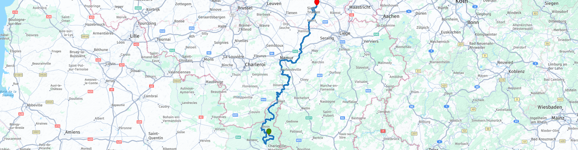
Alongside the Meuse river from Montherme to Alken

This route was brought to you by:
RouteXpert Guy Heyns - Adv. RouteXpert
Last edit: 10-12-2024
 Route Summary
 Every now and then a frivolous side jump is made on very nice roads that help to maintain your cornering talents, whether ascending or descending.
Enjoy this pleasant, relaxing ride that also takes you along Dinant, a tourist attraction in the Condroz.
 Share this route


Animation

Verdict


Duration
4h 49m

Mode of travel
Car or motorcycle

Distance
230.90 km

Countries


 RouteXpert Review
 It passes a number of nice places such as Givet & Dinant and you cross the Maas 10 times while you follow its banks for 174 kilometers.
Here and there, however, we leave these banks to look very fun and frivolously on the smaller roads to hone our cornering talents.
So plenty of variety on this return route from the French Ardennes.
As already mentioned, the route starts in Monthermé, France. First the banks of the Semois are followed, and then, believe it or not, to catch a 'colleke' in the North of France. Do not expect intensive bends or climbing on this 'Col du Liry', but rather enjoy the first magnificent forest you drive through (Forêt Domaniale de Château-Regnault) while 'descending' back to Bogny-sur-Meuse. There you will find a connection to the famous 'green' Michelin roads and these roads form a 'red' thread through this route, in which road quality is of paramount importance.
At Haybes, just after Fumay and after a possible refueling on the route (rp 6- 50 km) we cross the Meuse again and dive into some great forests (Forêt Domaniale de la Manise / d'Hargnes-Lurier & Bois de la Cloche). In the middle of these forests you will also get to process some nice pins, so that will be enjoyed from the front row.
You stay in this green area until you reach route point 8 and after 83 kilometers arrive in Givet, the last city before the French-Belgian border. Perhaps a short break is recommended here instead of in the higher Dinant. In contrast to Dinant, Givet offers ample parking options and perhaps also space on its terraces along the Maas. After all, in Dinant it can be very busy on a sunny weekend day….
At route point 10 (86 km) you pass the French-Belgian border and meander back to the Meuse, which you cross again in Hastière-Lavaux. You will then continue along the Meuse to Dinant (rp12 - 109 km).
Dinant is a tourist attraction with its Citadel and home to Adolphe Sax, the inventor of the saxophone. It can be very busy on a summer day. Parking options in and around the center are very limited, even for motorcycles. Maybe something to take into account ...
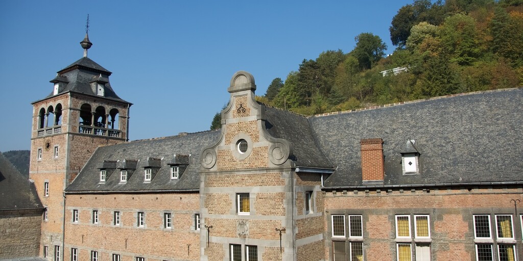
Just after leaving Dinant there is another very nice attraction and that is the Leffe Abbey (rp13). You will probably have no trouble recognizing the Abbey tower. This is depicted on the 13 different types of Leffe beer that originated in this abbey. Today, however, the Leffe varieties are brewed in Leuven and 'royalties' are paid to the abbey.
If Dinant is or was too busy, you can stop at route point 15, barely 8 kilometers after Dinant, at a small but nice picnic area for a short break.
Enjoy the roads that are cut here and the peace and nature they offer you. It will soon get busier when you approach the city of Namur. To avoid the crowds there, we stay on the right side of the Maas to dive back into the woods after the Naamse bend. The Bois de Jeumont, d'Herpet, Rouquimont, Lier, de la Justice, the Gresves, the Faux,… they all slide under your wheels, just to illustrate the beautiful, green area you cross here. At route point 23 and after 173 kilometers you will arrive in Andenne where, just before you cross the Maas for the 10th and last time, you can take a short break in a pleasant square.
For the rest, the ride to Alken then follows beautiful, good and rural roads where the speed from route point 26 is reduced to 70 km / h outside the built-up area. After all, you are back in Flanders, where different speed limits apply. From the Walloon-Flemish border it is then another 23 kilometers to the arrival in Alken, where you can enjoy a last farewell drink in 'De Ton' or in 'Sportwereld'.
This return route from the French Ardennes is particularly varied and offers something for everyone. Excellent road surface, beautiful nature, varied views, quite a bit of history, nice hills and even a real 'col' are your part on this route that deserves a five star rating because of its surprising, yet always fascinating route.

 Links
Links  Usage
Usage Want to download this route?
You can download the route for free without MyRoute-app account. To do so, open the route and click 'save as'. Want to edit this route?
No problem, start by opening the route. Follow the tutorial and create your personal MyRoute-app account. After registration, your trial starts automatically.  Disclaimer
Use of this GPS route is at your own expense and risk. The route has been carefully composed and checked by a MyRoute-app accredited RouteXpert for use on TomTom, Garmin and MyRoute-app Navigation.
Changes may nevertheless have occurred due to changed circumstances, road diversions or seasonal closures. We therefore recommend checking each route before use.
Preferably use the route track in your navigation system. More information about the use of MyRoute-app can be found on the website under 'Community' or 'Academy'.

Wallonia
About this region
The Walloon Region (French: Région wallonne [ʁeʒjɔ̃ walɔn]; German: Wallonische Region; Dutch: Waals gewest), usually simply referred to as Wallonia (; French: Wallonie [walɔni]; Walloon: Waloneye; German: Wallonien [vaˈloːni̯ən] (listen) or Wallonie [valoˈniː]; Dutch: Wallonië [ʋɑˈloːnijə] (listen)), is one of the three Regions of Belgium—alongside the Flemish Region and the Brussels-Capital Region.Covering the southern portion of the country, Wallonia is primarily French-speaking, and accounts for 55% of Belgium's territory, but only a third of its population. The Walloon Region was not merged with the French Community of Belgium, which is the political entity responsible for matters related mainly to culture and education, because the French Community of Belgium encompasses both Wallonia and the bilingual Brussels-Capital Region.
There is a German-speaking minority in eastern Wallonia, resulting from the annexation of three cantons previously part of the German Empire at the conclusion of World War I. This community represents less than 1% of the Belgian population. It forms the German-speaking Community of Belgium, which has its own government and parliament for culture-related issues.
During the industrial revolution, Wallonia was second only to the United Kingdom in industrialization, capitalizing on its extensive deposits of coal and iron. This brought the region wealth, and from the beginning of the 19th to the middle of the 20th century, Wallonia was the more prosperous half of Belgium. Since World War II, the importance of heavy industry has greatly diminished, and the Flemish Region has exceeded Wallonia in wealth as Wallonia has declined economically. Wallonia now suffers from high unemployment and has a significantly lower GDP per capita than Flanders. The economic inequalities and linguistic divide between the two are major sources of political conflicts in Belgium and a major factor in Flemish separatism.
The capital of Wallonia is Namur, and the most populous city is Charleroi. Most of Wallonia's major cities and two-thirds of its population lie along the east-west aligned Sambre and Meuse valley, the former industrial backbone of Belgium. To the north of this valley, Wallonia lies on the Central Belgian Plateau, which, like Flanders, is a relatively flat and agriculturally fertile area. The south and southeast of Wallonia is made up of the Ardennes, an expanse of forested highland that is less densely populated.
Wallonia borders Flanders and the Netherlands (the province of Limburg) in the north, France (Grand Est and Hauts-de-France) to the south and west, and Germany (North Rhine-Westphalia and Rhineland-Palatinate) and Luxembourg (Capellen, Clervaux, Esch-sur-Alzette, Redange and Wiltz) to the east. Wallonia has been a member of the Organisation Internationale de la Francophonie since 1980.
Read more on Wikipedia
There is a German-speaking minority in eastern Wallonia, resulting from the annexation of three cantons previously part of the German Empire at the conclusion of World War I. This community represents less than 1% of the Belgian population. It forms the German-speaking Community of Belgium, which has its own government and parliament for culture-related issues.
During the industrial revolution, Wallonia was second only to the United Kingdom in industrialization, capitalizing on its extensive deposits of coal and iron. This brought the region wealth, and from the beginning of the 19th to the middle of the 20th century, Wallonia was the more prosperous half of Belgium. Since World War II, the importance of heavy industry has greatly diminished, and the Flemish Region has exceeded Wallonia in wealth as Wallonia has declined economically. Wallonia now suffers from high unemployment and has a significantly lower GDP per capita than Flanders. The economic inequalities and linguistic divide between the two are major sources of political conflicts in Belgium and a major factor in Flemish separatism.
The capital of Wallonia is Namur, and the most populous city is Charleroi. Most of Wallonia's major cities and two-thirds of its population lie along the east-west aligned Sambre and Meuse valley, the former industrial backbone of Belgium. To the north of this valley, Wallonia lies on the Central Belgian Plateau, which, like Flanders, is a relatively flat and agriculturally fertile area. The south and southeast of Wallonia is made up of the Ardennes, an expanse of forested highland that is less densely populated.
Wallonia borders Flanders and the Netherlands (the province of Limburg) in the north, France (Grand Est and Hauts-de-France) to the south and west, and Germany (North Rhine-Westphalia and Rhineland-Palatinate) and Luxembourg (Capellen, Clervaux, Esch-sur-Alzette, Redange and Wiltz) to the east. Wallonia has been a member of the Organisation Internationale de la Francophonie since 1980.
View region
 Statistics
  99
99Amount of RX reviews (Wallonia)
 27434
27434Amount of visitors (Wallonia)
 22710
22710Amount of downloads (Wallonia)
 Route Collections in this region
 The 10 most beautiful car and motorcycle routes in Limburg
Limburg, who thinks of Limburg, thinks of flan, coal mines, marl and the hill country. The coal mines have been closed for almost 40 years, the last load of coal was brought up from the Oranje-Nassau coal mine in Heerlen on 31 December and, as they say, South Limburg was transformed from Black to Green and unfortunately there is still little left. view of this period.
But not only pie, marl and coal in Limburg, but also a very beautiful province to tour by car or motorcycle and enjoy all the beauty that the province of Limburg has to offer. For this, the MyRoute app RouteXpert has put together a Top 10 of Car and Motorcycle routes for you.
All routes in this collection have been checked and made equal for TomTom, Garmin and MyRoute-app Navigation by a MyRoute-app RouteXpert.
If you think, I have a very nice route that should certainly not be missing from this collection, send it to:
email: routeexpert@myrouteapp.com
Subject: New Route for the Top 10 collection Province of Limburg composed by Hans van de Ven.
The route will then be reviewed and then added to the Top 10.
To make the Top 10 also the Top 10, 1 route will have to disappear from the Top 10, you can indicate this when submitting the new route.
Have fun with this collection and while driving one of these routes. Enjoy all the beauty that the Netherlands and in particular the province of Limburg has to offer. Click on “View route” to read the review of the chosen route.
I would like to hear your findings about the route(s).
View Route Collection
Top 5 Car and Motorcycle Routes in the Eifel
The Eifel is the eastern part of the medium plateau Eifel-Ardennes. It is located north of the Moselle and west of the Rhine. The largest part is in Germany, a small part is in Belgium, in the East Cantons. The German part of Eifel is located in the federal states of North Rhine-Westphalia and Rhineland-Palatinate. The highest point is the Hohe Acht with 747 meters.
Several chains can be distinguished in the Eifel:
The northernmost part is called the Nordeifel, which in Belgium connects to the High Fens;
To the east of this is the Ahrgebirge, this part is located north of the Ahr in the Ahrweiler district;
South of the Ahr is the Hohe Eifel (or Hocheifel), of which the Hohe Acht (747 m) is the highest point, and also the highest point in the entire Eifel region;
To the west, near the Belgian border, the hills are known as Schneifel, part of the wider Snow Eifel area with peaks reaching up to 698 metres;
South and east of the Hohe Eifel is the Volcano-Eifel, a volcanic area with many crater lakes (Maare).
The southern part of the Eifel is less high. The area is bisected by streams and rivers running southwards. These streams flow into the Moselle. The largest of these rivers is the Kyll; the hills around this river are known as the Kyllwald;
In the south, the Eifel ends in the Voreifel.
In the north of the Eifel there are some large reservoirs. The largest of these is the reservoir in the Roer that was created by the construction of the Roerdal dam.
The Nürburgring is also located in the Eifel, a well-known car circuit for Formula 1 races, among other things. Since 2004, part of the north of the Eifel has become the Eifel National Park. This National Park falls entirely within the German-Belgian nature park High Fens-Eifel. Another part of the Eifel falls within the South Eifel Nature Park.
Well-known throughout the Netherlands and Belgium by car and motorcyclists, so reason enough for the MyRoute app RouteXpert to compile a Top 5 of Car and Motorbike routes for you.
All routes in this collection have been checked and made equal for TomTom, Garmin and MyRoute-app Navigation by a MyRoute-app RouteXpert.
If you think, I have a very nice route that should certainly not be missing from this collection, send it to:
email: routeexpert@myrouteapp.com
Subject: New Route for the Top 5 collection Eifel composed by Hans van de Ven.
The route will then be reviewed and then added to the Top 5. To make the Top 5 also the Top 5, 1 route will have to disappear from the Top 5, you can indicate this when submitting the new route.
Have fun with this collection and while driving one of these routes. Enjoy all the beauty that the Eifel has to offer. Click on “View route” to read the review of the chosen route.
I would like to hear your findings about the route(s).
View Route Collection