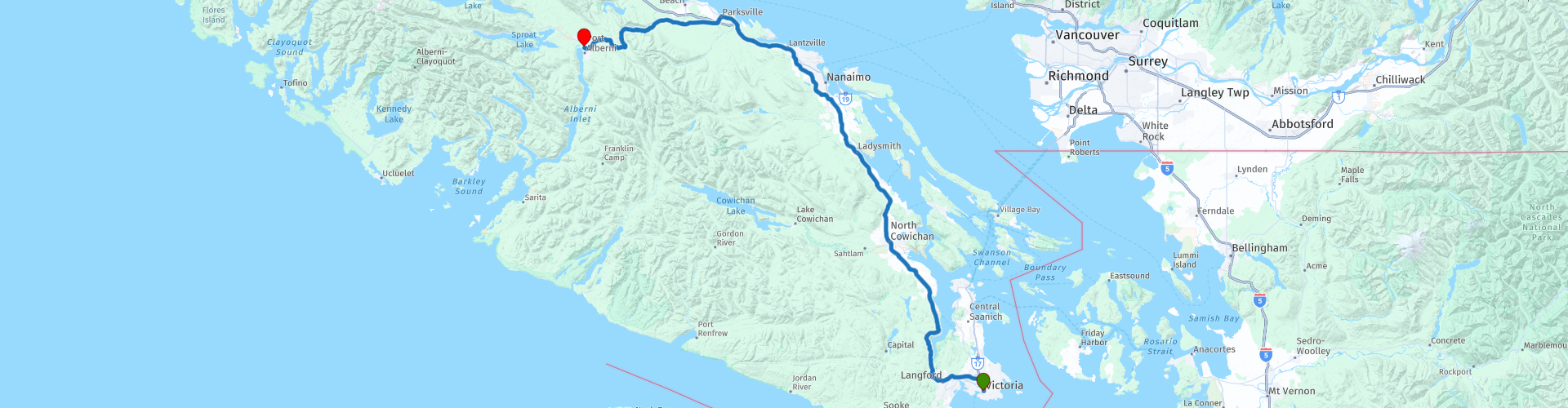
D13 Victoria Port Alberni

This route was brought to you by:
RouteXpert Hans van de Ven (Mr.MRA)
Last edit: 19-01-2021
 Route Summary
 The roads are good and the views along the way are so beautiful that you will also regularly stop in this route to capture it on photos.
Starting point: Best Western Plus Carlton Plaza Hotel
End point: Best Western Plus Barclay Hotel
The route has been made the same for TomTom, Garmin and MyRoute-app Navigation users.
Thanks to Richard & Lisa for the information!
 Share this route


Animation

Verdict


Duration
2h 48m

Mode of travel
Car or motorcycle

Distance
197.31 km

Countries

 RouteXpert Review
 The place Duncan is located on Vancouver Island, between Victoria and Nanaimo. In this place are old, historic buildings and there are nice restaurants and shops. Duncan is known as 'City of Totems' because totem poles can be seen along the road. A tour of local wine cellars and the first cidery of BC are worth it.
We head further north to Chemains, originally a logging city, to see the world's largest open-air gallery of murals and sculptures. To the north of Nanaimo are the Benson Falls and one of three in Benson Creek Falls Regional Park, just outside of Nanaimo. The Benson Creek Falls Regional Park is a 22-hectare park, you can walk in this park. The terrain can be difficult (and steep), therefore caution is required.
Between Parksville and Port Alberni, on both sides of Highway 4 (Alberni Highway) is a park with the largest douglass pairs on the island. Walk along the paths and see the centuries-old trees tower meters above you. In the south there are the thickest fir trees, with cross-sections of up to nine meters. On the other side of the road you will find orchards with Western red cedars, giant giant trees. Between the trees is a blanket of green ferns and mosses. Among other things, there live owls, deer, black bears and cougars.
Port Alberni is a port city with 21,000 inhabitants. The timber industry and the fishing industry are important: 3,000 tonnes of salmon are landed annually. You can visit the Valley Museum (art and culture of the First Nations), Robertson Creek Fish Hatchery (salmon farm) and the McLean Mill Historic Site (sawmill, including demonstrations). The city lies on a 48 kilometer long inlet, the Alberni Inlet. The Pacific Rim National Park, Barkley and Clayoquot Sound are beautiful nature reserves in the area.
In this 4-star route you will drive on beautiful good winding roads, through a beautiful environment, you will definitely stop at the Malahat viewpoint.
History:
The origin of Alberni was made possible by Adam Horne, a fur trader from the Hudson's Bay Company. He was instructed to find a route over Vancouver Island. He found a route to the Alberni Valley: the Horne Lake Trail. The route made it possible for settlers to settle in the area. The harbor town that emerged was named d'Alberni, a Spanish captain.
An important event in the history of the city, however crazy it may seem, was the American Civil War. A lot of wood was imported from America, but the supply was closed during the war. The Anderson Company from London then transported tools to Vancouver Island in 1861 and the first successful sawmill in British Columbia was a fact. Gilbert Sproat and Edward Stamp were responsible for the operation. Sproat Lake, Stamp River and Stamp Falls are named after these men.
In the same period, people were looking for gold in the China Creek. The mining extended to several waters around Port Alberni. Like other cities in Canada, the economy in Port Alberni received an economic boost when the railways were developed. The port grew and fishing became important. Nowadays, Port Alberni is a service center, with tourism as an emerging sector.


 Links
Links  Usage
Usage Want to download this route?
You can download the route for free without MyRoute-app account. To do so, open the route and click 'save as'. Want to edit this route?
No problem, start by opening the route. Follow the tutorial and create your personal MyRoute-app account. After registration, your trial starts automatically.  Disclaimer
Use of this GPS route is at your own expense and risk. The route has been carefully composed and checked by a MyRoute-app accredited RouteXpert for use on TomTom, Garmin and MyRoute-app Navigation.
Changes may nevertheless have occurred due to changed circumstances, road diversions or seasonal closures. We therefore recommend checking each route before use.
Preferably use the route track in your navigation system. More information about the use of MyRoute-app can be found on the website under 'Community' or 'Academy'.