Day 06 TCH Lake Louise to Calgary

This route was brought to you by:
RouteXpert René Plücken (MRA Master)
Last edit: 16-11-2025
 Route Summary
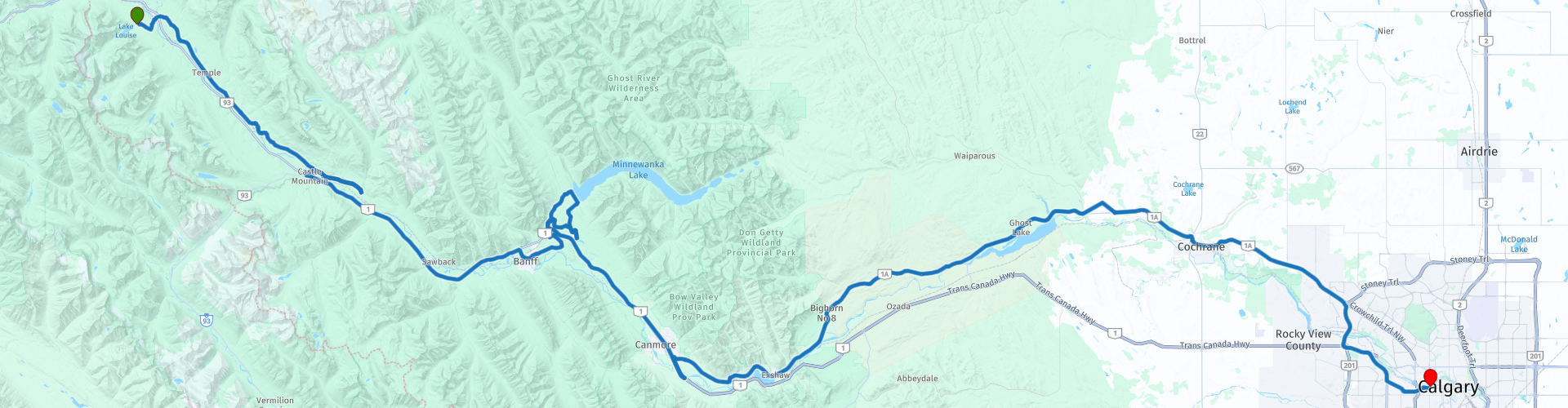
 This is section 6 which runs from Lake Louise to Calgary.
The Trans-Canada Highway passes through all of the country's southern provinces. The route can be driven in various ways, as there are several alternative routes that also belong to the Trans-Canada Highway. The total distance is around 8,000 km. We won't be driving solely the Trans-Canada Highway, but will be taking as much of the country's back roads as possible, as highway driving alone is too boring, and Canada boasts many beautiful roads through its stunning landscape.
You'll drive through all the provinces and through very diverse and picturesque landscapes, from the Rockies in the west, the Central Prairies to the eastern Maritimes and the northern forest.
The riding season is generally from April to October with longer seasons on the west coast and southern Ontario.
Make sure you have good all-season clothing or bring rain gear. Depending on the province and the season, the weather can change suddenly and you might be surprised by a rain shower, or even a snow or hail shower, so be prepared.
In Canada, the metric system is used, so speeds are indicated in km/h. Helmets are mandatory throughout Canada (DOT approved).
Throughout Canada, you'll see plenty of wildlife. Similar animals can be found from province to province, including deer, buffalo, moose, caribou, wolves, cougars, bears, mountain goats, sheep, lynx, coyotes, foxes, raccoons, badgers, various rodents, and a variety of birds.
Even though it is very tempting to stop for a photo, don't do it, it can be very dangerous.
This route is worth 5***** stars with its beautiful roads, nature, panoramas and beautiful sights.
 Share this route


Animation

Verdict


Duration
8h 46m

Mode of travel
Car or motorcycle

Distance
224.57 km

Countries

 RouteXpert Review
 The morning mist still hangs over Lake Louise as we start the engine. Ahead lies a 180-kilometer drive, but not on the boring four-lane Trans Canada Highway. No, today we're choosing adventure: the Bow Valley Parkway and later the Bow Valley Trail. This will be a day to cherish.
Before we leave, we'll stop at the Lake Louise Visitor Center for some extra information and perhaps a souvenir. Fill up the tank, because the road is calling.
The Bow Valley Parkway is no ordinary road; it's a winding ribbon through the Canadian wilderness, along the Bow River, with views that will make your heart beat faster. We stop at Morant's Curve. Before us lies a postcard: the river, the mountains, and, if we're lucky, a long freight train winding its way through the landscape.
Further on, Johnston Canyon awaits. We lace up our hiking boots for a short hike to the Lower Falls and the Upper Falls. The trail leads through a gorge, past cascading water, a place where natural power and beauty collide.
We take the TCH towards Banff. Here we take time for a delicious lunch. Banff is bustling with life, with museums, shops, and a riverside park. If you have time, you can easily spend a night here; this town deserves it.
After Banff, we stopped at Hoodoos Viewpoint. The jagged rock formations tower over the valley like sentinels. We took photos and inhaled deeply—this is Canada at its finest.
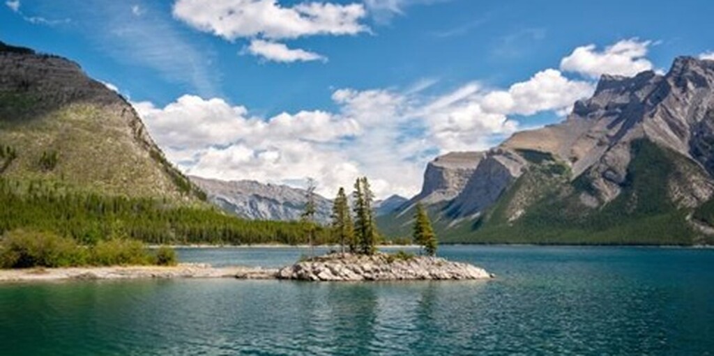
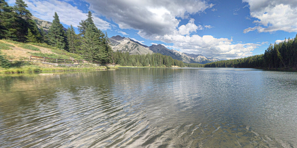
Before we get back on the highway, we'll drive the Lake Minnewanka Scenic Drive. A short loop with stunning views that will leave you speechless. We'll also pass Johnson Lake, an idyllic mountain lake surrounded by pine forests.
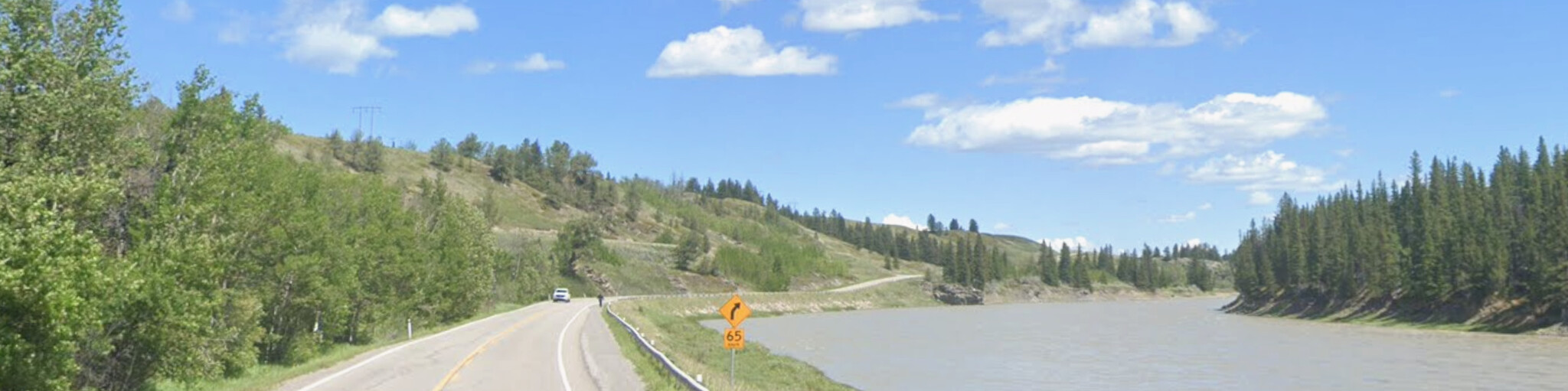
Back on the TCH, we take the turnoff for the Bow Valley Trail. This road winds through rolling countryside, with mountain backdrops and curves that will make any motorcyclist smile.
We'll stop at the Yamnuska Wolfdog Sanctuary. Here, we'll learn about wolfdogs, their challenges, and the importance of wolves in the wild. It's a place that not only moves you but also inspires you.
The final kilometres to Calgary offer a peaceful conclusion to a day full of impressions. As the city skyline looms, we know one thing for sure: this leg deserves five stars. It was a ride of contrasts, from mountain lakes to wild rock formations, from serene nature to bustling city life. A day you won't forget.
 Links
Links  Usage
Usage Want to download this route?
You can download the route for free without MyRoute-app account. To do so, open the route and click 'save as'. Want to edit this route?
No problem, start by opening the route. Follow the tutorial and create your personal MyRoute-app account. After registration, your trial starts automatically.  Disclaimer
Use of this GPS route is at your own expense and risk. The route has been carefully composed and checked by a MyRoute-app accredited RouteXpert for use on TomTom, Garmin and MyRoute-app Navigation.
Changes may nevertheless have occurred due to changed circumstances, road diversions or seasonal closures. We therefore recommend checking each route before use.
Preferably use the route track in your navigation system. More information about the use of MyRoute-app can be found on the website under 'Community' or 'Academy'.

Alberta
About this region
Alberta () is one of the thirteen provinces and territories of Canada. It is part of Western Canada and is one of the three prairie provinces. Alberta is bordered by British Columbia to the west, Saskatchewan to the east, the Northwest Territories (NWT) to the north, and the U.S. state of Montana to the south. It is one of the only two landlocked provinces in Canada. The eastern part of the province is occupied by the Great Plains, while the western part borders the Rocky Mountains. The province has a predominantly continental climate but experiences quick temperature changes due to air aridity. Seasonal temperature swings are less pronounced in western Alberta due to occasional chinook winds.Alberta is the 6th largest province by area at 661,848 square kilometres, and the 4th most populous, being home to 4,067,175 people. Alberta's capital is Edmonton, while Calgary is its largest city. The two are Alberta's largest census metropolitan areas (CMAs) and both exceed 1 million people. More than half of Albertans live in either Edmonton or Calgary, which contributes to continuing the rivalry between the two cities. English is the official language of the province. In 2016, 76.0% of Albertans were anglophone, 1.8% were francophone and 22.2% were allophone.The oil and gas industry is also a part of the province's identity. Alberta's economy is based on hydrocarbons, petrochemical industries, livestock, agriculture and frontier technologies. The oil industry has been a pillar of Alberta's economy since 1947, when substantial oil deposits were discovered at Leduc No. 1 well. Since Alberta is the province most rich in hydrocarbons, it provides 70% of the oil and natural gas exploited on Canadian soil. In 2018, Alberta's output was CDN$338.2 billion, 15.27% of Canada's GDP.In the past, Alberta's political landscape hosted parties like the left-wing Liberals and the agrarian United Farmers of Alberta, as well as the right-wing Social Credit Party and the Progressive Conservatives. Today, Alberta is generally perceived as a conservative province. The Progressive Conservatives held office continually from 1971 to 2015, the longest unbroken run in government at the provincial or federal level in Canadian history.
Before becoming part of Canada, Alberta was home to several First Nations and was a territory used by fur traders of the Hudson's Bay Company. The lands that would become Alberta were acquired by Canada as part of the NWT on July 15, 1870. On September 1, 1905, Alberta was separated from the NWT as a result of the Alberta Act and designated the 8th province of Canada. From the late 1800s to early 1900s, many immigrants arrived, the biggest wave of which was pushed by Wilfrid Laurier, to prevent the prairies from being annexed by Americans. Massive oil resources were discovered in Alberta in 1947.Alberta is renowned for its natural beauty, richness in fossils and for housing important nature reserves. Alberta is home to six UNESCO World Heritage Sites: The Canadian Rocky Mountain Parks, Dinosaur Provincial Park, the Head-Smashed-In Buffalo Jump, Waterton–Glacier International Peace Park, Wood Buffalo National Park and Writing-on-Stone Provincial Park. Other popular sites include: Banff, Canmore, Drumheller, Jasper, Sylvan Lake and Lake Louise.
Read more on Wikipedia
Before becoming part of Canada, Alberta was home to several First Nations and was a territory used by fur traders of the Hudson's Bay Company. The lands that would become Alberta were acquired by Canada as part of the NWT on July 15, 1870. On September 1, 1905, Alberta was separated from the NWT as a result of the Alberta Act and designated the 8th province of Canada. From the late 1800s to early 1900s, many immigrants arrived, the biggest wave of which was pushed by Wilfrid Laurier, to prevent the prairies from being annexed by Americans. Massive oil resources were discovered in Alberta in 1947.Alberta is renowned for its natural beauty, richness in fossils and for housing important nature reserves. Alberta is home to six UNESCO World Heritage Sites: The Canadian Rocky Mountain Parks, Dinosaur Provincial Park, the Head-Smashed-In Buffalo Jump, Waterton–Glacier International Peace Park, Wood Buffalo National Park and Writing-on-Stone Provincial Park. Other popular sites include: Banff, Canmore, Drumheller, Jasper, Sylvan Lake and Lake Louise.
View region
 Statistics
  8
8Amount of RX reviews (Alberta)
 13188
13188Amount of visitors (Alberta)
 364
364Amount of downloads (Alberta)
 Route Collections in this region
 Top car and motorcycle tour through Canada USA and the Rockies
Traveling by car or motorcycle through Canada, USA and the Rockies is a journey that you don't just make, so don't drive for 15 days and then return home. No, book a stay of several days in Vancouver, Jasper, Banff, Seattle and Port Alberni and again Vancouver to also visit several places of interest in these cities, so that this tour becomes an unforgettable tour that you can remember with pleasure.
Do not forget to arrange and pack the following items:
*This is only a summary and completely personal and may differ per person.
Take out travel insurance, +31 for numbers in GSM, (partially) take out gas, Health insurance coverage at destination?, Switch off electrical appliances, Lighting (time clock), Check passport validity, Antenna from radio/TV due to lightning, Residence address for those left behind, Remote control house alarm, Book Smart Parking.
Hand luggage:
Liquids in packaging of max. 100 ml, Liquids in hand luggage in transparent plastic bag.
For on the road:
Candy, Book, Earplugs, Country and road map(s), Directions, Maps in your navigation system
Money & Securities:
Bank card / giro card, Credit card (think pin code), Cash, Calculator for Internet banking, Medical insurance card, Travel insurance card.
Travel documents:
Passport, (International) Driver's License, Ticket(s), Reservation Tickets, Hotel Vouchers, Arrival/Departure Time, Check-in & Check-out Times, Valid Visa (ESTA), Travel Guide.
Clothing:
Underwear, Belt, Shirts/ T-shirts, Shorts, Long pants, Shoes, Socks, Swim trunks, Towel, Slippers.
Personal stuff:
Watch, House Keys, Wallet, Sunglasses.
Toiletries:
Deodorant, Shower gel / Soap, Comb / brush, Shaving equipment, Shampoo, Toothbrush, Toothpaste, Sanitary pads
Health & Medicine:
Own medicines, Insect repellent, Cold sore ointment, Ointment for insect bites, Sunscreen, Norit, Paracetamol, Suction cup for insect bites, First aid bag.
Miscellaneous:
Travel bag / waist bag, Leatherman (= checked luggage), Pen or pencil, Headlamp, Lighter, Tools & Electronics, Mobile phone & charger, Photo/video camera & charger, Memory card(s), World plug / adapter, Ipod & charger, Adapter cable Ipod, Headphones, iPad & charger, Navigation & charger/plug, Plug socket, Fuelpack battery.
Engine (accessories):
Helmet, Motorcycle clothing, Motorcycle boots, Chain lock / disc brake lock, Gloves, Bandana, Inner bags (plastic shopping bag), Insulation bag, Tension straps, Tie wraps, Rain suit, Rainaway.
Addresses:
Address list, Embassy telephone number, Telephone number to block (bank) card(s), Telephone number (airline tickets).
View Route Collection
Trans Canada Highway
The Trans-Canada Highway (TCH) or Trans-Canadian Highway is a system of highways that cover all 10 provinces of Canada.
The Federal and Provincial Highways System that now forms the TCH were authorized by the Trans-Canada Highway Act of 1948 and opened in 1962. It was completed in 1971. The total length of the TCH is 7821 km.
Contrary to the American Interstate Highway System, the TCH does not consist of an unambiguous network of motorways, but forms a network of restricted access highways and other main routes that are more akin to the Dutch provincial roads. The route is indicated by a green shield with a white maple leaf.
The numbering of the roads that are part of the TCH is the domain of the provinces. Only the western provinces have aligned their numbering and the TCH has the designation Highway 1 there.
The main route of the TCH starts in Victoria in British Columbia and runs via Calgary and Regina to Winnipeg. From Winnipeg the route leads to Kenora in Ontario, after which several branches pass through Ontario to Ottawa.
Further east, the route passes through the province of Quebec via Montreal and Quebec, among others, to Moncton, New Brunswick. Then the TCH continues east through Nova Scotia, where a branch (via the Confederation Bridge) leads to Prince Edward Island. Another section runs down to the sea in the port city of Sydney, where a ferry service leaves for Channel-Port aux Basques on the island of Newfoundland. From there the route continues for more than 900 km to the provincial capital of St. John's, in the extreme southeast of the island.
We not only drive the TCH, but will take the rural roads as much as possible, because only Highway driving is too boring and Canada has many beautiful roads through its beautiful landscape. You drive through all provinces and through very varied and scenic landscapes, from the Rockies in the West, the Central Prairies to the Eastern Maritimes and the Northern Forest.
The riding season is generally April through October with longer seasons on the west coast and southern Ontario. Provide good all season clothing or bring rain gear, depending on the province and the season the weather can change and you may be surprised by a rain or even a snow or hail shower, so be prepared.
In Canada the metric system is used, so speeds are indicated in Km / h. A helmet requirement (DOT approved) applies throughout Canada.
You will see many wildlife throughout Canada. This varies from province to province, such as deer, buffalos, moose, caribou, wolves, pumas, bears, mountain goats, sheep, lynx, coyotes, foxes, raccoons, badgers, various rodents and all kinds of birds. Even if it is very tempting to stop for a photo, don't do it, it can be very dangerous.
The routes described in this review sometimes deviate from the Trans Canada Highway, bringing the total length to 9,300 kilometers. The routes are made so that you drive through the beautiful parts of Canada with truly beautiful panoramas and beautiful sights to visit, this differs from museums, parks to historical points. The routes are not too long so there is time to stop for photos and sights along the way. You can also choose to arrange and combine the stages differently or to add other routes to shorten or extend your journey. The routes are marked with a rating in stars, some routes are less challenging or interesting but are necessary to drive to the next point, which is why they often have a lower rating.
In the route description you will find more details about the routes and the points of interest along the way. These points and also hotels, restaurants, petrol stations etc. are indicated with a POI and sometimes also with a Route point. In the description you will also find links to interesting sites and to the routes that connect to that day.
The described routes are;
Day 01 TCH Victory to Nanaimo
Day 02 TCH Nanaimo to Hope
Day 03 TCH Hope to Kamloops
Day 04 TCH Kamloops to Revelstoke
Day 05 TCH Revelstoke to Lake Louise
Day 06 TCH Lake Louise to Calgary
Day 07 TCH Calgary to Medicine Hat
Day 08 TCH Medicine Hat to Moose Jaw
Day 09 TCH Moose Jaw to Regina
Day 10 TCH Regina to Brandon
Day 11 TCH Brandon to Winnipeg
Day 12 TCH Winnipeg to Kenora
Day 13 TCH Kenora to Ignace
Day 14 TCH Ignace to Thunder Bay
Day 15 TCH Thunder Bay to Marathon
Day 16 Thunder Bay to Wawa
Day 17 TCH Wawa to Sault Ste Marie
Day 18 TCH Sault Ste Marie to Espanola
Day 19 TCH Espanola to Mattawa
Day 20 TCH Mattawa to Ottawa
Day 21 TCH Ottawa to Montreal
Day 22 TCH Montreal to Quebec
Day 23 TCH Quebec to Riviere du Loup
Day 24 TCH Riviere du Loup to Grand Falls
Day 25 TCH Grand Falls to Fredericton
Day 26 TCH Fredericton to Moncton
Day 27 TCH Moncton to Charlottetown
Day 28 TCH Charlottetown to Truro
Day 29 TCH Truro to North Sydney
Day 30 TCH North Sydney to Corner Brook
Day 31 TCH Corner Brook to Grand Falls
Day 32 TCH Grand Falls to Clarenville
Day 33 TCH Clarenville to St John.
Have fun reading the reviews and planning your next road trip.
If you have driven this trip, I am very curious about your feedback!
View Route Collection