Day 30 TCH North Sydney to Corner Brook

This route was brought to you by:
RouteXpert René Plücken (MRA Master)
Last edit: 24-11-2025
 Route Summary
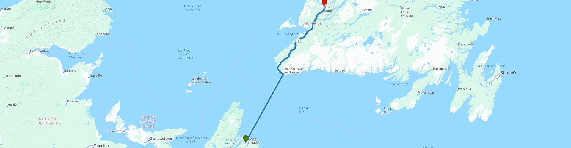
 This is section 30 which runs from North Sydney to Corner Brook.
The Trans-Canada Highway passes through all of the country's southern provinces. The route can be driven in various ways, as there are several alternative routes that also belong to the Trans-Canada Highway. The total distance is around 8,000 km. We won't be driving solely the Trans-Canada Highway, but will be taking as much of the country's back roads as possible, as highway driving alone is too boring, and Canada boasts many beautiful roads through its stunning landscape.
You'll drive through all the provinces and through very diverse and picturesque landscapes, from the Rockies in the west, the Central Prairies to the eastern Maritimes and the northern forest.
The riding season is generally from April to October with longer seasons on the west coast and southern Ontario.
Make sure you have good all-season clothing or bring rain gear. Depending on the province and the season, the weather can change suddenly and you might be surprised by a rain shower, or even a snow or hail shower, so be prepared.
In Canada, the metric system is used, so speeds are indicated in km/h. Helmets are mandatory throughout Canada (DOT approved).
Throughout Canada, you'll see plenty of wildlife. Similar animals vary from province to province, including deer, buffalo, moose, caribou, wolves, cougars, bears, mountain goats, sheep, lynx, coyotes, foxes, raccoons, badgers, various rodents, and a variety of birds.
Even though it is very tempting to stop for a photo, don't do it, it can be very dangerous.
There aren't many interesting stops along the route itself. However, you can stop at several spots to enjoy the beautiful panoramas. Therefore, I rate this route 3*** stars.
 Share this route


Animation

Verdict


Duration
13h 33m

Mode of travel
Car or motorcycle

Distance
394.94 km

Countries

 RouteXpert Review
 Today's itinerary includes a special leg: the crossing from Nova Scotia to Newfoundland. This is no ordinary journey, but a combination of sea and land, an experience you won't soon forget thanks to the stunning scenery and the unique ferry ride.
The ferry departs from North Sydney around midday (11:45, 12:30) or 11:15 pm, depending on the season and day. The crossing takes approximately 7 hours. Onboard, you'll find restaurants, bars, and the option to book a cabin for a comfortable journey.
Tip:
• Choose an evening crossing if you want to take another nice ride on day 29 and arrive rested.
• For an afternoon crossing, you can spend the night in Port aux Basques, because you will arrive between 7:00 and 8:00 PM.
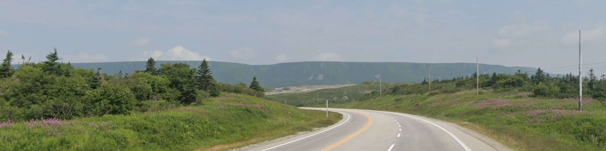
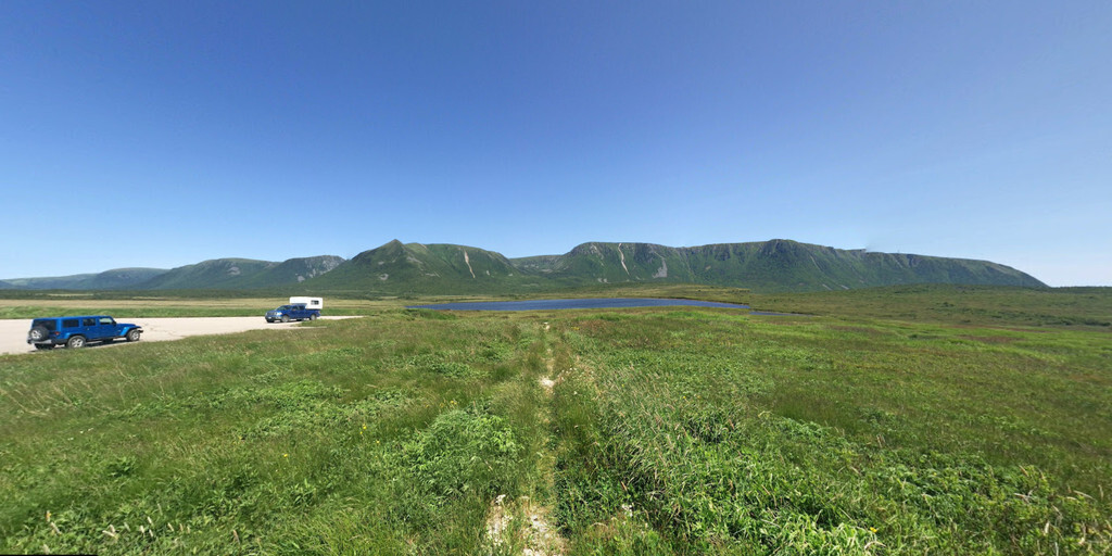
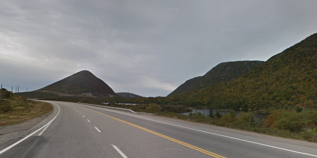
From Port aux Basques, it's another 220 km to Corner Brook on the Trans-Canada Highway (NL-1). This two-lane highway winds through a spectacular landscape of mountains, hills, rivers, and lakes. In some sections, the road is three or four lanes for safe passing.
Newfoundland was formed by a collision of tectonic plates 400 million years ago, creating impressive highlands and dramatic vistas. On one side, you see Saint Lawrence Bay, and on the other, mountains rise up.
There are no major sights along the route, but there are plenty of places to stop for photos of the stunning scenery.
The final destination, Corner Brook, is a town with a spectacular combination of ocean and mountain landscapes, four seasons, and friendly people. Corner Brook is known worldwide as a popular tourist attraction and one of the best places to live, work, and do business. Enjoy time to explore the town's beautiful network of walking trails. Peek into Corner Brook's unique culture at a local gallery or museum. Enjoy the great shops and restaurants in downtown.
My rating: ★★★, A unique day thanks to the ferry ride and Newfoundland's rugged landscape. No spectacular stops, just pure enjoyment of nature and the freedom of the road.
 Links
Links  Usage
Usage Want to download this route?
You can download the route for free without MyRoute-app account. To do so, open the route and click 'save as'. Want to edit this route?
No problem, start by opening the route. Follow the tutorial and create your personal MyRoute-app account. After registration, your trial starts automatically.  Disclaimer
Use of this GPS route is at your own expense and risk. The route has been carefully composed and checked by a MyRoute-app accredited RouteXpert for use on TomTom, Garmin and MyRoute-app Navigation.
Changes may nevertheless have occurred due to changed circumstances, road diversions or seasonal closures. We therefore recommend checking each route before use.
Preferably use the route track in your navigation system. More information about the use of MyRoute-app can be found on the website under 'Community' or 'Academy'.

Newfoundland and Labrador
About this region
Newfoundland and Labrador (; sometimes abbreviated as NL) is the easternmost province of Canada, in the country's Atlantic region. It is composed of the island of Newfoundland and the continental region of Labrador to the northwest, with a combined area of 405,212 square kilometres (156,500 sq mi). In 2018, the province's population was estimated at 525,073. About 94% of the province's population lives on the island of Newfoundland (and its neighbouring smaller islands), of whom more than half live on the Avalon Peninsula.
The province is Canada's most linguistically homogeneous, with 97.0% of residents reporting English (Newfoundland English) as their mother tongue in the 2016 census. Historically, Newfoundland was also home to unique varieties of French and Irish, as well as the extinct Beothuk language. In Labrador, the indigenous languages Innu-aimun and Inuktitut are also spoken.
Newfoundland and Labrador's capital and largest city, St. John's, is Canada's 20th-largest census metropolitan area and is home to almost 40 per cent of the province's population. St. John's is the seat of government, home to the House of Assembly of Newfoundland and Labrador and to the highest court in the jurisdiction, the Newfoundland and Labrador Court of Appeal.
Formerly a colony and then a dominion of the United Kingdom, Newfoundland gave up its independence in 1933, following significant economic distress caused by the Great Depression and the aftermath of Newfoundland's participation in World War I. It became the tenth and final province to enter Confederation on March 31, 1949, as "Newfoundland". On December 6, 2001, an amendment was made to the Constitution of Canada to change the province's name to Newfoundland and Labrador.
Read more on Wikipedia
The province is Canada's most linguistically homogeneous, with 97.0% of residents reporting English (Newfoundland English) as their mother tongue in the 2016 census. Historically, Newfoundland was also home to unique varieties of French and Irish, as well as the extinct Beothuk language. In Labrador, the indigenous languages Innu-aimun and Inuktitut are also spoken.
Newfoundland and Labrador's capital and largest city, St. John's, is Canada's 20th-largest census metropolitan area and is home to almost 40 per cent of the province's population. St. John's is the seat of government, home to the House of Assembly of Newfoundland and Labrador and to the highest court in the jurisdiction, the Newfoundland and Labrador Court of Appeal.
Formerly a colony and then a dominion of the United Kingdom, Newfoundland gave up its independence in 1933, following significant economic distress caused by the Great Depression and the aftermath of Newfoundland's participation in World War I. It became the tenth and final province to enter Confederation on March 31, 1949, as "Newfoundland". On December 6, 2001, an amendment was made to the Constitution of Canada to change the province's name to Newfoundland and Labrador.
View region
 Statistics
  4
4Amount of RX reviews (Newfoundland and Labrador)
 14475
14475Amount of visitors (Newfoundland and Labrador)
 145
145Amount of downloads (Newfoundland and Labrador)
 Route Collections in this region
 Trans Canada Highway
The Trans-Canada Highway (TCH) or Trans-Canadian Highway is a system of highways that cover all 10 provinces of Canada.
The Federal and Provincial Highways System that now forms the TCH were authorized by the Trans-Canada Highway Act of 1948 and opened in 1962. It was completed in 1971. The total length of the TCH is 7821 km.
Contrary to the American Interstate Highway System, the TCH does not consist of an unambiguous network of motorways, but forms a network of restricted access highways and other main routes that are more akin to the Dutch provincial roads. The route is indicated by a green shield with a white maple leaf.
The numbering of the roads that are part of the TCH is the domain of the provinces. Only the western provinces have aligned their numbering and the TCH has the designation Highway 1 there.
The main route of the TCH starts in Victoria in British Columbia and runs via Calgary and Regina to Winnipeg. From Winnipeg the route leads to Kenora in Ontario, after which several branches pass through Ontario to Ottawa.
Further east, the route passes through the province of Quebec via Montreal and Quebec, among others, to Moncton, New Brunswick. Then the TCH continues east through Nova Scotia, where a branch (via the Confederation Bridge) leads to Prince Edward Island. Another section runs down to the sea in the port city of Sydney, where a ferry service leaves for Channel-Port aux Basques on the island of Newfoundland. From there the route continues for more than 900 km to the provincial capital of St. John's, in the extreme southeast of the island.
We not only drive the TCH, but will take the rural roads as much as possible, because only Highway driving is too boring and Canada has many beautiful roads through its beautiful landscape. You drive through all provinces and through very varied and scenic landscapes, from the Rockies in the West, the Central Prairies to the Eastern Maritimes and the Northern Forest.
The riding season is generally April through October with longer seasons on the west coast and southern Ontario. Provide good all season clothing or bring rain gear, depending on the province and the season the weather can change and you may be surprised by a rain or even a snow or hail shower, so be prepared.
In Canada the metric system is used, so speeds are indicated in Km / h. A helmet requirement (DOT approved) applies throughout Canada.
You will see many wildlife throughout Canada. This varies from province to province, such as deer, buffalos, moose, caribou, wolves, pumas, bears, mountain goats, sheep, lynx, coyotes, foxes, raccoons, badgers, various rodents and all kinds of birds. Even if it is very tempting to stop for a photo, don't do it, it can be very dangerous.
The routes described in this review sometimes deviate from the Trans Canada Highway, bringing the total length to 9,300 kilometers. The routes are made so that you drive through the beautiful parts of Canada with truly beautiful panoramas and beautiful sights to visit, this differs from museums, parks to historical points. The routes are not too long so there is time to stop for photos and sights along the way. You can also choose to arrange and combine the stages differently or to add other routes to shorten or extend your journey. The routes are marked with a rating in stars, some routes are less challenging or interesting but are necessary to drive to the next point, which is why they often have a lower rating.
In the route description you will find more details about the routes and the points of interest along the way. These points and also hotels, restaurants, petrol stations etc. are indicated with a POI and sometimes also with a Route point. In the description you will also find links to interesting sites and to the routes that connect to that day.
The described routes are;
Day 01 TCH Victory to Nanaimo
Day 02 TCH Nanaimo to Hope
Day 03 TCH Hope to Kamloops
Day 04 TCH Kamloops to Revelstoke
Day 05 TCH Revelstoke to Lake Louise
Day 06 TCH Lake Louise to Calgary
Day 07 TCH Calgary to Medicine Hat
Day 08 TCH Medicine Hat to Moose Jaw
Day 09 TCH Moose Jaw to Regina
Day 10 TCH Regina to Brandon
Day 11 TCH Brandon to Winnipeg
Day 12 TCH Winnipeg to Kenora
Day 13 TCH Kenora to Ignace
Day 14 TCH Ignace to Thunder Bay
Day 15 TCH Thunder Bay to Marathon
Day 16 Thunder Bay to Wawa
Day 17 TCH Wawa to Sault Ste Marie
Day 18 TCH Sault Ste Marie to Espanola
Day 19 TCH Espanola to Mattawa
Day 20 TCH Mattawa to Ottawa
Day 21 TCH Ottawa to Montreal
Day 22 TCH Montreal to Quebec
Day 23 TCH Quebec to Riviere du Loup
Day 24 TCH Riviere du Loup to Grand Falls
Day 25 TCH Grand Falls to Fredericton
Day 26 TCH Fredericton to Moncton
Day 27 TCH Moncton to Charlottetown
Day 28 TCH Charlottetown to Truro
Day 29 TCH Truro to North Sydney
Day 30 TCH North Sydney to Corner Brook
Day 31 TCH Corner Brook to Grand Falls
Day 32 TCH Grand Falls to Clarenville
Day 33 TCH Clarenville to St John.
Have fun reading the reviews and planning your next road trip.
If you have driven this trip, I am very curious about your feedback!
View Route Collection