Day 21 TCH Ottawa to Montreal

This route was brought to you by:
RouteXpert René Plücken (MRA Master)
Last edit: 16-11-2025
 Route Summary
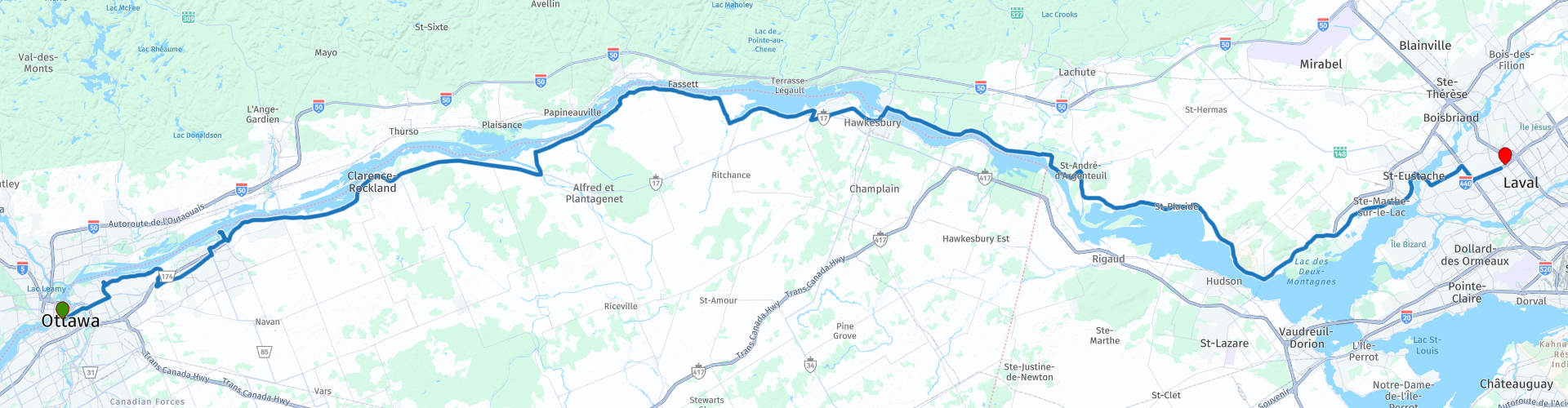
 This is section 21 which runs from Ottawa to Montreal.
The Trans-Canada Highway passes through all of the country's southern provinces. The route can be driven in various ways, as there are several alternative routes that also belong to the Trans-Canada Highway. The total distance is around 8,000 km. We won't be driving solely the Trans-Canada Highway, but will be taking as much of the country's back roads as possible, as highway driving alone is too boring, and Canada boasts many beautiful roads through its stunning landscape.
You'll drive through all the provinces and through very diverse and picturesque landscapes, from the Rockies in the west, the Central Prairies to the eastern Maritimes and the northern forest.
The riding season is generally from April to October with longer seasons on the west coast and southern Ontario.
Make sure you have good all-season clothing or bring rain gear. Depending on the province and the season, the weather can change suddenly and you might be surprised by a rain shower, or even a snow or hail shower, so be prepared.
In Canada, the metric system is used, so speeds are indicated in km/h. Helmets are mandatory throughout Canada (DOT approved).
Throughout Canada, you'll see plenty of wildlife. Similar animals vary from province to province, including deer, buffalo, moose, caribou, wolves, cougars, bears, mountain goats, sheep, lynx, coyotes, foxes, raccoons, badgers, various rodents, and a variety of birds.
Even though it is very tempting to stop for a photo, don't do it, it can be very dangerous.
My rating: ★★★★★, Five stars for a route full of variety: museums, nature, historical sites and winding roads along the river.
 Share this route


Animation

Verdict


Duration
9h 40m

Mode of travel
Car or motorcycle

Distance
222.21 km

Countries

 RouteXpert Review
 This road trip is anything but boring. Instead of the fast Trans Canada Highway (ON417), we choose a route that winds along the Ottawa River, through charming villages, green landscapes, and past historic sites. This is a day to savor every bend, a worthy end to this journey.
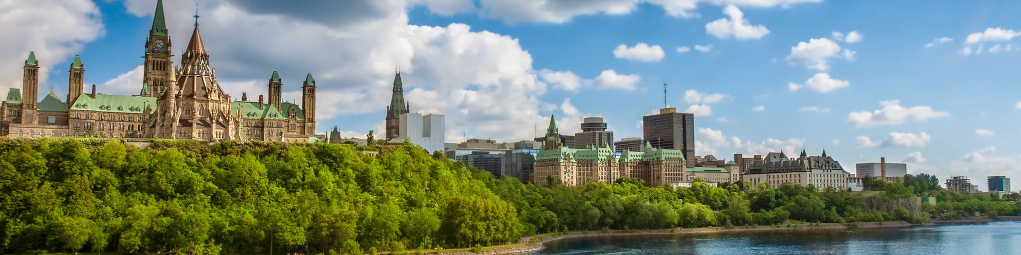
Before leaving Ottawa, we'll stop at Parliament Hill. The iconic buildings of the Parliament of Canada, the Centennial Flame, and the view over the river make this a perfect photo stop.
Just outside Ottawa, we visit the Canadian Aviation and Space Museum. Here you'll find an impressive collection of aircraft and space artifacts, from bush planes to military aircraft and even war trophies from WWI. A must-see for technology and history enthusiasts.
We follow the Sir George Étienne Cartier Parkway through a green area and then drive to Petrie Island, an island in the Ottawa River and an idyllic place with beaches and nature, ideal for a short break.
We'll visit the Cumberland Heritage Village Museum. This open-air museum transports you to rural life in the 1920s and 1930s, complete with historic buildings and interactive activities.
Via Jessup Falls, we cross the South Nation River on a steel bridge. On the other side is a small park, a nice place to rest for a while. Then we follow Route 21 and Concession Road 1, winding along the Ottawa River through rolling countryside.
Hawkesbury has plenty of restaurants for a hearty lunch. Motorcycle enthusiasts can even visit a Harley-Davidson dealership.
On the north side of the Ottawa River we drive along the Rte des Outaouais and stop at:
• Carillon Dam: an impressive hydroelectric power plant operated by Hydro Québec, built in the 1960s.
• Parc National d'Oka: a nature park with beaches, wetlands, and historic chapels. Perfect for a short walk or simply enjoying the view over Lac des Deux Montagnes.
From Oka, it's another 50 kilometers to Montreal. The city is brimming with culture, gastronomy, and architecture; definitely plan an extra day to explore everything.
My rating: ★★★★★, Five stars for a route full of variety: museums, nature, historical sites and winding roads along the river.
 Links
Links  Usage
Usage Want to download this route?
You can download the route for free without MyRoute-app account. To do so, open the route and click 'save as'. Want to edit this route?
No problem, start by opening the route. Follow the tutorial and create your personal MyRoute-app account. After registration, your trial starts automatically.  Disclaimer
Use of this GPS route is at your own expense and risk. The route has been carefully composed and checked by a MyRoute-app accredited RouteXpert for use on TomTom, Garmin and MyRoute-app Navigation.
Changes may nevertheless have occurred due to changed circumstances, road diversions or seasonal closures. We therefore recommend checking each route before use.
Preferably use the route track in your navigation system. More information about the use of MyRoute-app can be found on the website under 'Community' or 'Academy'.

Quebec
About this region
Quebec (, sometimes ; French: Québec [kebɛk] (listen)) is one of the thirteen provinces and territories of Canada. Quebec is the largest province by area and the second-largest by population. Much of the population lives in urban areas along the St. Lawrence River, between the most populous city, Montreal, and the provincial capital, Quebec City. Quebec is the home of the Québécois nation. Located in Central Canada, the province shares land borders with Ontario to the west, Newfoundland and Labrador to the northeast, New Brunswick to the southeast, and a coastal border with Nunavut; in the south it borders Maine, New Hampshire, Vermont, and New York in the United States.
Between 1534 and 1763, Quebec was called Canada and was the most developed colony in New France. Following the Seven Years' War, Quebec became a British colony: first as the Province of Quebec (1763–1791), then Lower Canada (1791–1841), and lastly Canada East (1841–1867), as a result of the Lower Canada Rebellion. It was confederated with Ontario, Nova Scotia, and New Brunswick in 1867, beginning the Canadian Confederation. Until the early 1960s, the Catholic Church played a large role in the social and cultural institutions in Quebec. However, the Quiet Revolution of the 1960s to 1980s increased the role of the Government of Quebec in l'État québécois (state of Quebec).
The Constitution Act, 1867 incorporated the present-day Government of Quebec, which functions within the context of a Westminster system and is both a liberal democracy and a constitutional monarchy with a parliamentary system. The Premier of Quebec, presently François Legault, acts as head of government. Québécois political culture mostly differs on a nationalist-vs-federalist continuum, rather than a left-vs-right continuum. Quebec independence debates have played a large role in politics. Quebec society's cohesion and specificity is based on three of its unique statutory documents: the Quebec Charter of Human Rights and Freedoms, the Charter of the French Language, and the Civil Code of Quebec. Furthermore, unlike elsewhere in Canada, law in Quebec is mixed: private law is exercised under a civil-law system, while public law is exercised under a common-law system.
Quebec's official language is French; Québécois French is the local variety. The economy of Quebec is diversified and post-industrial. Quebec's substantial natural resources, notably exploited in hydroelectricity, forestry, and mining, have also long been a mainstay. Quebec is well known for producing maple syrup, for its comedy, and for making hockey one of the most popular sports in Canada. It is also renowned for its culture; the province produces literature, music, films, TV shows, festivals, folklore, and more.
Read more on Wikipedia
Between 1534 and 1763, Quebec was called Canada and was the most developed colony in New France. Following the Seven Years' War, Quebec became a British colony: first as the Province of Quebec (1763–1791), then Lower Canada (1791–1841), and lastly Canada East (1841–1867), as a result of the Lower Canada Rebellion. It was confederated with Ontario, Nova Scotia, and New Brunswick in 1867, beginning the Canadian Confederation. Until the early 1960s, the Catholic Church played a large role in the social and cultural institutions in Quebec. However, the Quiet Revolution of the 1960s to 1980s increased the role of the Government of Quebec in l'État québécois (state of Quebec).
The Constitution Act, 1867 incorporated the present-day Government of Quebec, which functions within the context of a Westminster system and is both a liberal democracy and a constitutional monarchy with a parliamentary system. The Premier of Quebec, presently François Legault, acts as head of government. Québécois political culture mostly differs on a nationalist-vs-federalist continuum, rather than a left-vs-right continuum. Quebec independence debates have played a large role in politics. Quebec society's cohesion and specificity is based on three of its unique statutory documents: the Quebec Charter of Human Rights and Freedoms, the Charter of the French Language, and the Civil Code of Quebec. Furthermore, unlike elsewhere in Canada, law in Quebec is mixed: private law is exercised under a civil-law system, while public law is exercised under a common-law system.
Quebec's official language is French; Québécois French is the local variety. The economy of Quebec is diversified and post-industrial. Quebec's substantial natural resources, notably exploited in hydroelectricity, forestry, and mining, have also long been a mainstay. Quebec is well known for producing maple syrup, for its comedy, and for making hockey one of the most popular sports in Canada. It is also renowned for its culture; the province produces literature, music, films, TV shows, festivals, folklore, and more.
View region
 Statistics
  5
5Amount of RX reviews (Quebec)
 14352
14352Amount of visitors (Quebec)
 228
228Amount of downloads (Quebec)
 Route Collections in this region
 Trans Canada Highway
The Trans-Canada Highway (TCH) or Trans-Canadian Highway is a system of highways that cover all 10 provinces of Canada.
The Federal and Provincial Highways System that now forms the TCH were authorized by the Trans-Canada Highway Act of 1948 and opened in 1962. It was completed in 1971. The total length of the TCH is 7821 km.
Contrary to the American Interstate Highway System, the TCH does not consist of an unambiguous network of motorways, but forms a network of restricted access highways and other main routes that are more akin to the Dutch provincial roads. The route is indicated by a green shield with a white maple leaf.
The numbering of the roads that are part of the TCH is the domain of the provinces. Only the western provinces have aligned their numbering and the TCH has the designation Highway 1 there.
The main route of the TCH starts in Victoria in British Columbia and runs via Calgary and Regina to Winnipeg. From Winnipeg the route leads to Kenora in Ontario, after which several branches pass through Ontario to Ottawa.
Further east, the route passes through the province of Quebec via Montreal and Quebec, among others, to Moncton, New Brunswick. Then the TCH continues east through Nova Scotia, where a branch (via the Confederation Bridge) leads to Prince Edward Island. Another section runs down to the sea in the port city of Sydney, where a ferry service leaves for Channel-Port aux Basques on the island of Newfoundland. From there the route continues for more than 900 km to the provincial capital of St. John's, in the extreme southeast of the island.
We not only drive the TCH, but will take the rural roads as much as possible, because only Highway driving is too boring and Canada has many beautiful roads through its beautiful landscape. You drive through all provinces and through very varied and scenic landscapes, from the Rockies in the West, the Central Prairies to the Eastern Maritimes and the Northern Forest.
The riding season is generally April through October with longer seasons on the west coast and southern Ontario. Provide good all season clothing or bring rain gear, depending on the province and the season the weather can change and you may be surprised by a rain or even a snow or hail shower, so be prepared.
In Canada the metric system is used, so speeds are indicated in Km / h. A helmet requirement (DOT approved) applies throughout Canada.
You will see many wildlife throughout Canada. This varies from province to province, such as deer, buffalos, moose, caribou, wolves, pumas, bears, mountain goats, sheep, lynx, coyotes, foxes, raccoons, badgers, various rodents and all kinds of birds. Even if it is very tempting to stop for a photo, don't do it, it can be very dangerous.
The routes described in this review sometimes deviate from the Trans Canada Highway, bringing the total length to 9,300 kilometers. The routes are made so that you drive through the beautiful parts of Canada with truly beautiful panoramas and beautiful sights to visit, this differs from museums, parks to historical points. The routes are not too long so there is time to stop for photos and sights along the way. You can also choose to arrange and combine the stages differently or to add other routes to shorten or extend your journey. The routes are marked with a rating in stars, some routes are less challenging or interesting but are necessary to drive to the next point, which is why they often have a lower rating.
In the route description you will find more details about the routes and the points of interest along the way. These points and also hotels, restaurants, petrol stations etc. are indicated with a POI and sometimes also with a Route point. In the description you will also find links to interesting sites and to the routes that connect to that day.
The described routes are;
Day 01 TCH Victory to Nanaimo
Day 02 TCH Nanaimo to Hope
Day 03 TCH Hope to Kamloops
Day 04 TCH Kamloops to Revelstoke
Day 05 TCH Revelstoke to Lake Louise
Day 06 TCH Lake Louise to Calgary
Day 07 TCH Calgary to Medicine Hat
Day 08 TCH Medicine Hat to Moose Jaw
Day 09 TCH Moose Jaw to Regina
Day 10 TCH Regina to Brandon
Day 11 TCH Brandon to Winnipeg
Day 12 TCH Winnipeg to Kenora
Day 13 TCH Kenora to Ignace
Day 14 TCH Ignace to Thunder Bay
Day 15 TCH Thunder Bay to Marathon
Day 16 Thunder Bay to Wawa
Day 17 TCH Wawa to Sault Ste Marie
Day 18 TCH Sault Ste Marie to Espanola
Day 19 TCH Espanola to Mattawa
Day 20 TCH Mattawa to Ottawa
Day 21 TCH Ottawa to Montreal
Day 22 TCH Montreal to Quebec
Day 23 TCH Quebec to Riviere du Loup
Day 24 TCH Riviere du Loup to Grand Falls
Day 25 TCH Grand Falls to Fredericton
Day 26 TCH Fredericton to Moncton
Day 27 TCH Moncton to Charlottetown
Day 28 TCH Charlottetown to Truro
Day 29 TCH Truro to North Sydney
Day 30 TCH North Sydney to Corner Brook
Day 31 TCH Corner Brook to Grand Falls
Day 32 TCH Grand Falls to Clarenville
Day 33 TCH Clarenville to St John.
Have fun reading the reviews and planning your next road trip.
If you have driven this trip, I am very curious about your feedback!
View Route Collection