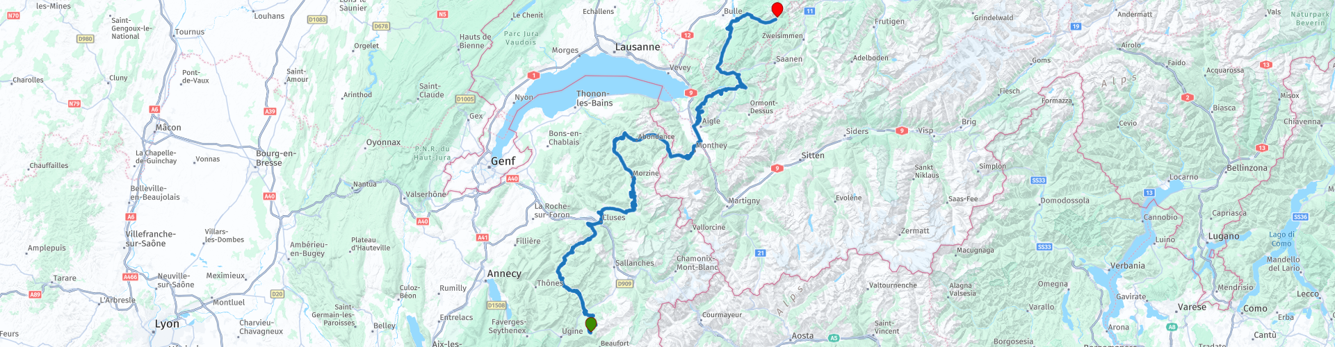
03 Von Les Saisies ueber verschiedene Alpenpaesse durch das Wallis in die Freiburger Alpen nach Jaun

This route was brought to you by:
RouteXpert David Ruprecht
Last edit: 21-11-2023
 Route Summary
 This route also contains everything a biker's heart desires: winding mountain stretches, hairpin bends as well as long cruiser curves and many sections away from heavy traffic. This tour rightly deserves the highest rating of five stars.
This tour also contains a few challenging sections. Nevertheless, with appropriately adjusted driving behavior and speed, it is no problem even for beginners.
 Share this route


Animation

Verdict


Duration
11h 8m

Mode of travel
Car or motorcycle

Distance
266.51 km

Countries


 RouteXpert Review
 This route also contains everything a biker's heart desires: winding mountain stretches, hairpin bends as well as long cruiser curves and many sections away from heavy traffic. This tour rightly deserves the highest rating of five stars.
This tour also contains a few challenging sections. Nevertheless, with appropriately adjusted driving behavior and speed, it is no problem even for beginners.
After a hearty breakfast from the well-stocked buffet in the Hotel Le Very, after a few meters you go over the pass that gives the place its name: Les Saisies. Then we go down through several tourist towns to Le Fumet, which from experience shows that there is usually a lot of traffic, so we drive comfortably into the valley. Since there are hardly any gas stations in the region, it is important to take advantage of the opportunity when the tank is rather empty. Immediately after the serpentines and the bridge, turn sharp right and drive around six kilometers until you reach Praz sur Arly, where there is a gas station at the roundabout outside the village.
But we still have full tanks from the day before and drive straight ahead where the road winds up to the Col des Aravis. We climb continuously through the narrow, wooded valley of the Arrondine, winding through the mountain village of Les Giettaz and soon afterwards we reach the Col des Aravis, where we treat ourselves to a warming coffee. The view to the left and right of the road up to the high peaks is impressive.
Strengthened, we continue down to Saint-Jean-de-Sixt, where we also pass the inconspicuous Col de Saint-Jean-de-Sixt. A small warning: The large restaurant immediately after the roundabout on the left with the many bicycles on the railing is not recommended. We suffered from diarrhea and nausea for a long time after lunch there...
Now we drive through and further through the Chinaillon valley to Samance and there towards Col. There we go left up to the Col de la Colombière, which we cross after a short while. Of course not before we take a few photos of the wonderful view. Down in the next valley we leave the official Route des Grandes Alpes shortly after Scionzier and follow the Giffre river for a few kilometers before taking on the climb to the Col de joux plane. We can't pass the view at one bend over the Giffre valley and the southern Alps without a souvenir photo, that would be a shame. And at the top of the pass we finally have a well-deserved lunch. Here you would also have the opportunity to linger a while, enjoy the beautiful mountain lake and the wonderful view.
Fortified with fine local specialties, we follow the route over the Col du Ran Folly, which is barely recognizable as a pass, and return to the famous route of the Grandes Alpes in Morzine. But only for a few kilometers, because we now definitely turn our backs on it and drive over the small and beautiful Col du Combier, take the path east in the Dranse d'Abondance valley and follow the signpost towards Switzerland in Châtel.
We cross the border at the old Les Morgins customs station, marvel at the small lake of the same name and soon drive through the well-known holiday village of Morgins. Now it goes gently at first, then over several serpentines down towards the valley floor of the Valais. After the last loop or the new roundabout there, just on the hill, after a few hundred meters we stop on the right at the gas station and restaurant “La Cavagne”. Originally it was purely a farm shop, i.e. a farm with a shop. Today it is a bright, large shop with local specialties and a restaurant. The terrace offers a great view over the Rhone Valley and the high peaks on the north side of the valley. Friendly service, excellent coffee and, above all, a highly recommended dessert: a compilation of all the house specialties on a small plate. From a culinary point of view, it's hard to beat it.
So sweetly we take on the next section and, once we reach the valley floor, we only drive a short stretch along the Rhone before we cross the dreamy wine-growing village of Yvorne to the north, where the equally famous and fine white wine with this name comes from. Immediately after the last vines, the tightest and steepest curves of the entire tour begin. It is important to be careful here, especially because oncoming traffic is expected.
Shortly after the hamlet of Louan there is a large board that specifies the rules: You can always go up from XX.00h to XX.15h, down from XX.30h to XX.45h. As an alternative, without a time limit, you can also take the route via Le Serpey and the Col des Mosses. This route would be about 30 minutes shorter, but not as exciting and impressive.
However, we drive the last part up through a lot of forest and the old curved military tunnels within the permitted time window. Shortly after the tunnel, an impressive view over Lake Geneva awaits us. I recommend driving a few hundred meters further and then stopping for the views and photos. You can see more of the lake and Mont Blanc. As you continue along the route you can see impressive mountains to the left and right (be sure to look back to the right!), which are not very high, but some of which have rock formations like those in the Dolomites.
Unfortunately, you can hardly see the Lac de l'Hongrier, the reservoir on the left below the road, and there is no useful vantage point. The road leads over 48 bridges, all numbered, and joins the Col des Mosses road at La Lecherette. But we turn away from the pass and turn left towards Château d'Oex. The descent from the Col des Mosses, which we are now descending, is also very beautiful and offers some wonderful curves. Shortly before the bottom of the valley we turn left towards Bulle/Fribourg. Shortly after Moulin, the next village, we leave the main road and follow side paths on the other side of the valley of the Saane and the dreamy narrow-gauge railway line. It goes along the Lac du Vernex to the narrowing of the valley, where we switch back to the main road.
Now we drive on the main road over long curves and through villages to Gruyére. We can't miss this picturesque, uniquely well-preserved medieval town with the impressive castle. To visit the castle, the optional film screening is highly recommended and is worth it, even if it quickly takes 2 hours. Strolling through the short but beautiful old town takes you back 500 years. If you would like to enjoy this atmosphere for a little longer, treat yourself to a delicious dinner in one of the many restaurants along the street. Traditionally, a typical Swiss cheese fondue is recommended, with the world-famous Gruyère cheese and Vacherin from the cheese dairy in the village. And for fans of science fiction, there is also the museum of HR Giger, who created the sets and characters for many well-known films.
From Gruyére drive via Broc (there is a chocolate factory to visit, for those with a sweet tooth ????) and Charmey up the Val de Jogne to Jaun. Our tour ends here, at the Hotel Wasserfall. The small mountain village offers a lot of leisure activities and, as it is a bit away from the main tourist flows, also wonderful peace and relaxation.


 Links
Links  Usage
Usage Want to download this route?
You can download the route for free without MyRoute-app account. To do so, open the route and click 'save as'. Want to edit this route?
No problem, start by opening the route. Follow the tutorial and create your personal MyRoute-app account. After registration, your trial starts automatically.  Disclaimer
Use of this GPS route is at your own expense and risk. The route has been carefully composed and checked by a MyRoute-app accredited RouteXpert for use on TomTom, Garmin and MyRoute-app Navigation.
Changes may nevertheless have occurred due to changed circumstances, road diversions or seasonal closures. We therefore recommend checking each route before use.
Preferably use the route track in your navigation system. More information about the use of MyRoute-app can be found on the website under 'Community' or 'Academy'.

Auvergne Rhone Alpes
About this region
Auvergne-Rhône-Alpes (ARA; French: [ovɛʁɲ ʁon‿alp] (listen); Arpitan: Ôvèrgne-Rôno-Ârpes; Occitan: Auvèrnhe Ròse Aups; Italian: Alvernia-Rodano-Alpi) is a region in southeast-central France created by the 2014 territorial reform of French regions; it resulted from the merger of Auvergne and Rhône-Alpes. The new region came into effect on 1 January 2016, after the regional elections in December 2015.The region covers an area of 69,711 km2 (26,916 sq mi), making it the third largest in metropolitan France; it had a population of 7,948,287 in 2017, second to Île-de-France. It consists of twelve departments and one territorial collectivity (Lyon Metropolis) with Lyon as the prefecture.
This new region combines diverse geographical, sociological, economic and cultural regions, which was already true of Rhône-Alpes, as well as Auvergne, to a lesser extent. While the old Rhône-Alpes and Auvergne regions each enjoyed a unity defined by axes of communication and the pull of their respective metropoles, the new combination is heterogeneous; it sustained lively opposition from some local officials after its creation.
Read more on Wikipedia
This new region combines diverse geographical, sociological, economic and cultural regions, which was already true of Rhône-Alpes, as well as Auvergne, to a lesser extent. While the old Rhône-Alpes and Auvergne regions each enjoyed a unity defined by axes of communication and the pull of their respective metropoles, the new combination is heterogeneous; it sustained lively opposition from some local officials after its creation.
View region
 Statistics
  119
119Amount of RX reviews (Auvergne Rhone Alpes)
 45229
45229Amount of visitors (Auvergne Rhone Alpes)
 5440
5440Amount of downloads (Auvergne Rhone Alpes)
 Route Collections in this region
 The 24 Most Beautiful Alpine Routes
The Alps, The Alps are a mountain range in Europe, stretching from the French Mediterranean coast in the southwest to the Pannonian Plain in the east. The area of the mountain range is more than 200,000 km².
In other words Passes and Mountain Roads!
Driving through the mountains is great! Especially over the mountain passes with hairpin bends and narrow winding roads. Every bend a different view where you can enjoy. There are many beautiful mountain passes in the Alps.
A selection that has also been incorporated into these routes:
The Stlevio Pass:
The Stelvio Pass, also known as Passo dello Stelvio, is mainly known for the stage in the Giro d'Italia. Due to the length and the difference in height, this pass is seen as one of the toughest tests in cycling. The Stelvio Pass reaches a maximum height of 2758 meters and is therefore one of the highest in the Alps. The pass connects the towns of Bormio and Prato Allo Stelvio. In winter the pass is closed due to heavy snowfall.
The Reschenpass:
The Reschenpass, also known as Passo di Resia, connects the Austrian state of Tyrol with the Italian province of South Tyrol. The pass reaches a maximum height of 1,504 meters and has been one of the most important north-south connections in the Alps in recent centuries. The pass was used long before Roman times. Along the way you will pass several highlights and historical relics. One of the highlights is the Reschensee. This lake was created after the construction of the dam and has completely submerged the village of Graun. The only thing that reminds of that is the clock tower in the middle of the lake.
Col du Galibier:
The French mountain pass Col du Galibier connects the towns of Saint-Michel-de-Maurienne and Briançon via the Col du Lautaret in the south and the Col du Télégraphe in the north. The mountain pass is part of the Tour de France and very much feared, due to the fact that it can only be reached via the other two mountain passes. The pass reaches a maximum height of 2646 meters. From there you can take a walk to the viewpoint at 2704 meters. You can admire the peaks of the Grand Galibier, Mont Blanc and La Meije here.
The Grossglockner High Alpine Road:
With a height of 3798 meters the Grossglockner is the highest mountain in Austria. To fully enjoy this impressive mountain, you can drive over the Grossglockner High Alpine Road and the accompanying pass. The route starts from Bruck am Grossglockner and ends in Heiligenblut. Of course you can drive in two directions. The pass reaches a maximum height of 2504 meters and is closed in winter due to heavy snowfall. Along the way you pass several stops with fun activities, information points, mountain huts and viewpoints. A visit to the Kaiser-Franz-Josefs-Höhe and Pasterzen Glacier is highly recommended.
The Col d'Izoard:
Just like the Col du Galibier, the Col d'Izoard is also part of a stage of the Tour de France. The mountain pass connects Briançon with the valley of the river Guil. The pass is partly located in the Regional Natural Park du Queyras and reaches a maximum height of 2360 meters. What is special about the Col d'Izoard is the barren and rocky landscape. Sometimes it feels like driving a car over the moon! Along the way you can stop at several points to enjoy the beautiful view.
The Bernina Pass:
The Bernina Express is one of the most famous rail trains in Switzerland and the Alps. The route is beautiful and partly included on the UNESCO World Heritage List. Parallel to the railway lies the Bernina pass, which connects the Veltlin valley with the Egandin valley. This beautiful Alpine road has a total length of 56 kilometers and reaches a maximum height of 2328 meters. Along the way you can enjoy views of the Morteratsch Glacier.
The Sella Pass:
The Sella Pass, also known as Passo di Sella, takes you over one of the most impressive mountain ranges in the Dolomites: the Sella massif. The pass connects Valle di Fassa with Val Gardena and reaches a maximum height of 2236 meters. At this height is also the border of the Italian provinces of Trentino and Bolzano. Along the way you can enjoy the view of this spectacular mountain world. Admire, for example, the three peaks of the Sasso Lungo massif, the Sella massif or the peaks of the Marmolada. You can also drive the Sella pass in combination with the Gardena pass, Pordoi pass and Campolongo pass.
The Grimsel Pass:
The Grimsel Pass connects Goms in Wallis with the Halis Valley in the Bernese Oberland. The pass reaches a maximum elevation of 2165 meters and is closed in winter due to snowfall. Over the centuries, the mountain pass has played an important role in trade between Switzerland and Italy. Now it is mainly the reservoirs that have an important function. These are used to generate electricity. The landscape you drive through is rugged, rocky and impressive. On top of the pass is a hotel and a restaurant with a special marmot park. The Dodensee (Totensee) is also located here. This lake owes its name to the many soldiers who died in the time of Napoleon.
The Gotthard Pass:
The Gotthard Pass, also known as Passo del San Gottardo and Saint Gotthard, connects the Swiss towns of Airolo and Andermatt. The mountain pass and associated tunnel are especially known among holidaymakers driving from Switzerland to Italy. But where the majority opt for the tunnel, it is precisely the pass that really completes the holiday. The Gotthard Pass has a length of about 26 kilometers and reaches a maximum height of 2106 meters. The route is beautiful and takes you along old villages and beautiful views.
The Silvretta High Alpine Road and Silvretta Pass:
The Paznaun Valley in Tyrol and the Montafon in Vorarlberg are connected by the Silvretta High Alpine Road. The route has a length of 22.3 kilometers and leads from Galtür to Partenen in 34 hairpin bends, via the 2032 meter high Bielerhöhe. The Silvrettasee is also located at this point, where you can enjoy a lovely walk. The pass is closed in winter due to snowfall.
The Simplon Pass:
Just like the Gotthard Pass, many holidaymakers also travel over the Simplon Pass every year. This mountain pass connects the Rhone Valley in the canton of Valais with the Valle d'Ossola in Piemonte. The pass is open all year round and reaches a maximum height of 2005 meters. Along the way you pass a number of buildings, including the well-known Simplon Hospiz from 1825. The hospiz is managed by the monks of St. Bernard. From the highest point on the pass, all kinds of hiking routes are possible and you will also come across a hotel where you can spend the night.
The Gerlos Pass:
The Gerlos Pass connects the Salzach Valley in the Salzburgerland with the Zillertal Valley in Tyrol. The pass is part of the Gerlos Alpenstraße and runs right through the Hohe Tauern National Park. Along the way you can enjoy beautiful views of the surroundings. The pass has a length of 12 kilometers and reaches a maximum height of 1531 meters. A ride over the Gerlos Pass can be ideally combined with a visit to the Krimmler Wasserfälle.
The Great St. Bernard Pass:
The Great St. Bernard Pass, better known as Col du Grand Saint Bernard, connects the Italian province of Valle d'Aosta with the Swiss canton of Valais. The pass is one of the highest in Switzerland and reaches a maximum height of 2469 meters. Like a number of other mountain passes in this list, the Great St. Bernard Pass has also been used as a connecting road for centuries. The pass is named after the St. Bernard dogs that used to help stranded travelers along with the monks. The pass is closed in winter.
The Timmelsjoch High Alpine Road:
The Timmelsjoch High Alpine Road connects the towns of Sölden in the Ötztal and Meran in South Tyrol. Tolls must be paid on the Hochgurgl - Moos route. Via a mountain road with about 60 hairpin bends you drive through a beautiful mountain world. With the Timmelsjoch Experience you can learn more about the history, the road and the environment via various stations. You can also visit the Top Mountain Crosspoint museum.
Col de l'Iseran:
With a maximum pass height of 2770 meters, the Col l'Iséran is one of the highest mountain passes in the Alps. The pass connects Bourg-Saint-Maurice with Bonneval-sur-Arc. Via a road full of hairpin bends you pass, among other things, Val-d'Isère and a side valley of the Maurienne that lies entirely in the National Park de la Vanoise. You can spot animals such as marmots and chamois and there is also a restaurant with a chapel on top of the pass.
The Gavia Pass:
The Gavia Pass (Italian Passo di Gavia) is a mountain pass in the Italian Alps, in the Lombardy region.
It is one of the highest pass roads in Europe. The road leads through the unspoilt Stelvio National Park. The road was built in the First World War to supply Italian soldiers who fought in the Italian-Austrian border area. The pass height is one of the most beautiful in the Alps. Here is the large Lago Bianco with, to the north, the mountain San Matteo (3684 meters). Lago Nero is slightly lower on the south side of the pass. Here the mountain group of the Adamello determines the view. There are many well-marked walks in the area. During the winter the pass is closed due to the heavy snowfall. The pass is often closed until May and June due to the large amount of snow.
Promoter has made a selection of the 24 Most Beautiful Alpine routes that they have set out in recent years.
The routes go through:
France
Austria
Switzerland
Italy
The most beautiful roads, the most beautiful views, the most beautiful viewpoints. The highest mountains, the fastest descents, hairpin bend after hairpin bend, you name it you can't get enough of it.
If you go on holiday in this region, take advantage of it, ALL routes in this collection have been checked and made equal for TomTom, Garmin and MyRoute-app Navigation by a MyRoute-app RouteXpert.
Have fun with this collection and while driving one of these routes. Enjoy all the beauty that the Alps and the Dolomites have to offer. Click on “View route” to read the review of the chosen route.
I would like to hear your findings about the route(s).
View Route Collection
25 Magnificent trails in France
This MRA route collection contains 25 beautiful motorcycle routes in different parts of France, such as the Ardennes, the Alsace, Vercors, the Drôme, the Ardèche, Cote d'Azure, Gorges du Verdon, the Ariège, the Dordogne and Brittany.
The routes have been carefully created by Bert Loorbach, who is an enthusiastic motorcyclist himself. He lived in France for a year and a half, during which time he devoted himself to mapping the unknown and beautiful back roads of France especially for motorcyclists.
The routes are bundled in the Motortourgids France part 1 of Kosmos publishing house and now also available in MyRouteApp.
I have taken over the routes in MRA and sometimes adjusted them slightly to make them even more interesting for the motorcyclist.
View Route Collection