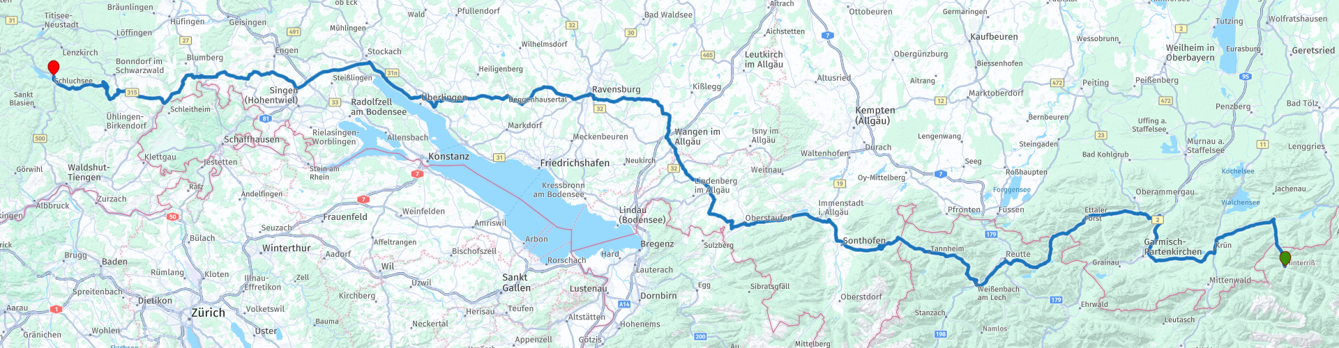
8 From Hinteriss to Schluchsee in Schwarzwald

This route was brought to you by:
RouteXpert Guy Heyns - Sr RouteXpert
Last edit: 10-12-2024
 Route Summary
 It takes you along some wonderful roads to the South of the Black Forest so that you can also enjoy nice parts of this playground on the return ride. The famous '500' or the Schwarzwaldhochstrasse is so easy to reach.
You can also use the route as a shortcut to the French Vosges.
It may be a long route, but it follows long, sloping and relaxing roads.
Do not expect any technical challenges, but instead enjoy the changing landscape where some beautiful mountain massifs will certainly not escape you as you gently leave the Alps.
 Share this route


Animation

Verdict


Duration
6h 26m

Mode of travel
Car or motorcycle

Distance
361.77 km

Countries


 RouteXpert Review
 Immediately after leaving the hotel and a lovely ride along the Rissbach river, you will already pass the Austrian-German border for the first time and drive - after the toll gate (rp3) - through the Karwendel nature reserve strongly westward. Enjoy the beautiful views here, the view of the river Isar and the mountain ranges that will occasionally call for your attention through the forests.
You will find a first petrol station after 25 kilometers on the route (rp4).
From route point 5 you get a view of the famous Olympic ski jump of Garmisch-Partenkirchen and at route point 6 you will pass Schloss Linderhof, which was created after a visit by (the jealous?) Louis II to the Palace of Versailles.
At route point 7 you dive back into Austria, on the way to the beautiful and clean Plansee (rp 5).
The road between the Karwendel nature reserve and the Plansee is a real pleasure. The roads are of an intensely good quality and we suspect that many photographers come here when they have to study beautiful, sloping, forest-lined roads ...
A first break is highly recommended at the Plansee. You will certainly not be the only motorcyclist who gives himself and his machine a break here. As beautiful as the Plansee is, there is a dark side to it ... Many will not know, but in WWII a subcamp of Dachau, the famous concentration camp was established here ...
And it will not be the last time that you will encounter Hitler on this route…, but don't let that stop you from enjoying the beautiful mountain ranges that you will encounter everywhere along the route. You are on your way to leave the Alpine region, but they seem to keep saying goodbye to you… they may not want you to leave…
Even after the Plansee, the beautiful roads continue with a slight break in the vicinity of Reutte, where you still touch the urban area. If you are looking for a nice picnic spot, you can possibly deviate from the route at rp 9 towards the ruins of Schlosskopf, where you also get a magnificent view of the Lech valley.
After Reutte (rp10), the Gaicht and Oberjoch pass await you (between rp 11 & 15). The latter after a passage through the particularly beautiful Tannheimertall, where you not only pass the Haldensee (rp12), but also the Austrian-German border (rp13) for the last time.
Enjoy the panoramic views here and do not think that the official name of the Overjochpass between 1938 and 1945 was in fact the Adolf-Hitler-Pass….
The attentive rider will also notice the landscape changes as you slowly leave the Alpine region.
You can take a break at the Grosser Alpsee (rp16) a little further away at Seeterrasse Alpenstrand. Parking is available nearby.
The route then gently continues towards Bodensee or 'Lake Constance' as it is called in the English language. Keep in mind that traffic in the vicinity of Lake Constance can be slightly busier.
When you leave Lake Constance, the attentive driver will notice that the landscape changes slowly, almost imperceptibly even… small hills get bigger and the bends always just that little bit different…. you are approaching the Black Forest… .. From route point 26 even all the way, because then you really dive into the famous area. Not for long, however, because the end of this long journey is now only a stone's throw away. You will soon see the Schluchtsee emerge, after which you can enjoy a well-deserved rest at this beautiful, albeit artificial inland sea.
The Hinteriss-Schluchsee ride is a fairly long cut-through route that offers the ideal balance between effective crossing and route fun. The route glides on nothing but excellent road surface, offers plenty of breaks and is also geologically quite instructive, if you want to pay attention to the typically changing landscape features while leaving the Alps. It seems as if the Alps find it difficult to say goodbye to you and therefore offer you an extensive farewell tour during this ride.
You can therefore not but enjoy this relaxing ride, the beautiful views, the refreshing lakes, the gently sloping roads and the extensive forests and nature reserves through which you travel. Because of all these characteristics, we give the route the 4.5 stars rating it deserves. Should she offer the same with a few miles less, she deserved the full five stars. Because no matter how you turn or turn it, you will need time to complete this 362 kilometer long tour on only minor roads, especially if you really want to enjoy the beauty of this tour.


 Links
Links  Usage
Usage Want to download this route?
You can download the route for free without MyRoute-app account. To do so, open the route and click 'save as'. Want to edit this route?
No problem, start by opening the route. Follow the tutorial and create your personal MyRoute-app account. After registration, your trial starts automatically.  Disclaimer
Use of this GPS route is at your own expense and risk. The route has been carefully composed and checked by a MyRoute-app accredited RouteXpert for use on TomTom, Garmin and MyRoute-app Navigation.
Changes may nevertheless have occurred due to changed circumstances, road diversions or seasonal closures. We therefore recommend checking each route before use.
Preferably use the route track in your navigation system. More information about the use of MyRoute-app can be found on the website under 'Community' or 'Academy'.

Baden-Württemberg
About this region
Baden-Württemberg (; German: [ˌbaːdn̩ ˈvʏʁtəmbɛʁk] (listen)), commonly shortened to BW or BaWü, is a German state (Bundesland) in Southwest Germany, east of the Rhine, which forms the southern part of Germany's western border with France. With more than 11.07 million inhabitants as of 2019 across a total area of nearly 35,752 km2 (13,804 sq mi), it is the third-largest German state by both area (behind Bavaria and Lower Saxony) and population (behind North Rhine-Westphalia and Bavaria). As a federated state, Baden-Württemberg is a partly-sovereign parliamentary republic. The largest city in Baden-Württemberg is the state capital of Stuttgart, followed by Mannheim and Karlsruhe. Other major cities are Freiburg im Breisgau, Heidelberg, Heilbronn, Pforzheim, Reutlingen, Tübingen, and Ulm.
What is now Baden-Württemberg was formerly the historical territories of Baden, Prussian Hohenzollern, and Württemberg. Baden-Württemberg became a state of West Germany in April 1952 by the merger of Württemberg-Baden, South Baden, and Württemberg-Hohenzollern. These states had just been artificially created by the Allies after World War II out of the existing traditional states Baden and Württemberg by their separation over different occupation zones.
Baden-Württemberg is especially known for its strong economy with various industries like car manufacturing, electrical engineering, mechanical engineering, the service sector, and more. It has the third highest gross regional product (GRP) in Germany. Part of the Four Motors for Europe, some of the largest German companies are headquartered in Baden-Württemberg, including Daimler, Porsche, Bosch and SAP.
The sobriquet Ländle (a diminutive of the word "Land" in the local Swabian, Alemannic and Franconian dialects) is sometimes used as a synonym for Baden-Württemberg.
Read more on Wikipedia
What is now Baden-Württemberg was formerly the historical territories of Baden, Prussian Hohenzollern, and Württemberg. Baden-Württemberg became a state of West Germany in April 1952 by the merger of Württemberg-Baden, South Baden, and Württemberg-Hohenzollern. These states had just been artificially created by the Allies after World War II out of the existing traditional states Baden and Württemberg by their separation over different occupation zones.
Baden-Württemberg is especially known for its strong economy with various industries like car manufacturing, electrical engineering, mechanical engineering, the service sector, and more. It has the third highest gross regional product (GRP) in Germany. Part of the Four Motors for Europe, some of the largest German companies are headquartered in Baden-Württemberg, including Daimler, Porsche, Bosch and SAP.
The sobriquet Ländle (a diminutive of the word "Land" in the local Swabian, Alemannic and Franconian dialects) is sometimes used as a synonym for Baden-Württemberg.
View region
 Statistics
  61
61Amount of RX reviews (Baden-Württemberg)
 51494
51494Amount of visitors (Baden-Württemberg)
 11117
11117Amount of downloads (Baden-Württemberg)
 Route Collections in this region
 Top 5 Car and Motorcycle Routes in the Black Forest
The Black Forest, who hasn't heard of it? The Black Forest is a densely forested area and low mountain range in southwestern Germany, located in the state of Baden-Württemberg, on the Rhine and the French border. It is the largest low mountain range in Germany. Geologically, it is related to the Vosges Mountains, which lie on the French side of the Rhine. The highest peak of the Black Forest is the Feldberg with a height of 1493 meters above sea level. The Black Forest is the largest forest area in Germany and consists mainly of pine and spruce trees. The Black Forest is known as one of the most popular tourist destinations in Germany. A small part in the north is protected as the Schwarzwald National Park. The Romans called the densely forested mountain range with its distinctive dark conifers Silva Nigra - "the Black or Dark Forest or impenetrable forest", which to them was ominous and almost impenetrable. The German word Schwarzwald was used for the first time in a document from the Swiss monastery of St. Gallen from the year 868. A well-known car route is the Schwarzwald-Hochstraße, B 500 and the Uhrenstraße. The Black Forest is known worldwide for the fairy tales of the Brothers Grimm.
There are also several lakes in the Black Forest, namely: Titisee, Glaswaldsee, Mummelsee, Kirnbergsee, Feldsee, Schluchsee and the Hotzenwald.
The highest peaks in the Black Forest are: Feldberg (1493 m), Seebuck (1448 m), Herzogenhorn (1415 m), Belchen (1414 m), Schauinsland (1284 m), Kandel (1243 m) and the Hornisgrinde (1164 m ).
Reason enough for the MyRoute app RouteXpert to compile a Top 5 of Car and Motorcycle Routes for you.
All routes in this collection have been checked and made equal for TomTom, Garmin and MyRoute-app Navigation by a MyRoute-app RouteXpert.
If you think, I have a very nice route that should certainly not be missing from this collection, send it to:
email: routeexpert@myrouteapp.com
Subject: New Route for the Top 5 collection Black Forest composed by Hans van de Ven.
The route will then be reviewed and then added to the Top 5. To make the Top 5 also the Top 5, 1 route will have to disappear from the Top 5, you can indicate this when submitting the new route.
Have fun with this collection and while driving one of these routes. Enjoy all the beauty that the Black Forest has to offer. Click on “View route” to read the review of the chosen route.
I would like to hear your findings about the route(s).
View Route Collection
11 day trip from the Netherlands
8 countries in 11 days; The Netherlands, Germany, Austria, Italy, Switzerland, France, Luxembourg and Belgium. This route collections consists of 10 routes that I have driven with friends in the summer of 2019.
The start is in Geldermalsen Netherlands, the first 7 days you drive through the Netherlands, Germany, Austria, Italy, Switzerland, France and a piece of Luxembourg with overnight stays in hotels.
The last three days you stay in Barweiler (D) in the Eifel and you drive two beautiful tours through the Eifel, Luxembourg and parts of the Belgian Ardennes.
There is no highway in the routes, only beautiful provincial and country roads, many beautiful passes with beautiful panoramas.
Be sure to check whether the passes are open before you leave.
These are routes for experienced drivers.
View Route Collection