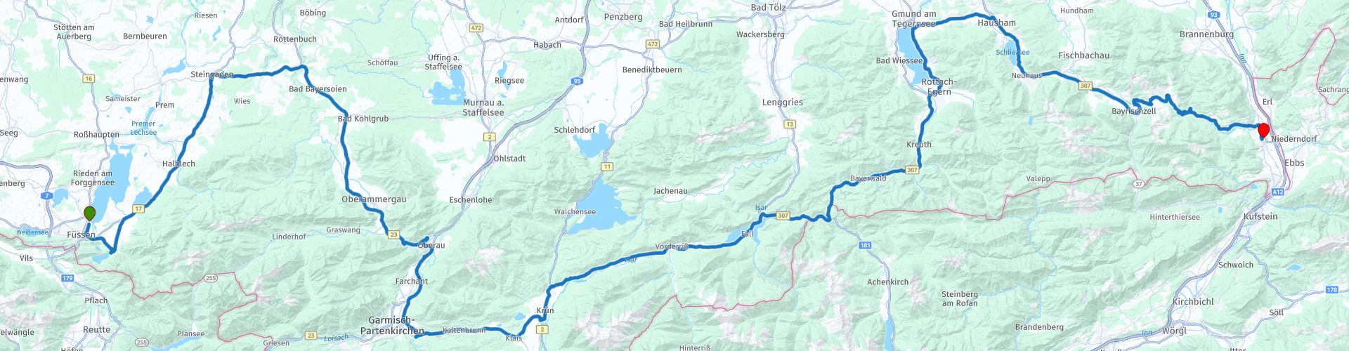
Fussen to Oberaudorf

This route was brought to you by:
RouteXpert Marcel Scherpenkate
Last edit: 10-04-2021
 Route Summary
 The route has been equalized for TomTom, Garmin and MyRoute-app Navigation users.
I rate this route with the maximum number of 5 stars, I have been allowed to drive this route myself and it is a succession of diversity of landscape via beautiful roads connected by equally authentic villages and panoramic views. Wonderful to drive through.
 Share this route


Animation

Verdict


Duration
7h 32m

Mode of travel
Car or motorcycle

Distance
196.18 km

Countries

 RouteXpert Review
 The Lech is not navigable due to its wild nature and gravel beds.
When you leave Füssen you have a view of Schloss Neuschwanstein in the village of Hohenschwangau. This is a real tourist spot, because Schloss Hohenschwangau is also located here.
You can spend a whole day at these 2 locations alone. You might consider staying at the Hotel for a day longer to see it all. I've included a link for visiting options at the bottom of this review.
The Bavarian kings used to seek refuge in the area around Füssen. Maximilian II, King of Bavaria, built his residence Hohenschwang in the nineteenth century at the foot of the mighty Säuling mountain peak, where the royal family spent many summers.
His son Ludwig II built there opposite Neuschwanstein Castle, his medieval dream castle and refuge, far from obligatory court ceremonies and administrative troubles.
After Hohenschwangau you leave the Allgäu and enter Upper Bavaria. This area is characterized by its numerous baroque churches and monasteries. Nice to see is the Welfenmünster in Steingaden - a Norbertine monastery renovated in Rococo style.
In Steingarden you turn right on the Ammergauerstrasse. You are going over the Ammer, also called the Amper is the largest tributary of the Isar in southern Bavaria. It generally flows northeast, reaching the Isar in Moosburg, about 190 kilometers from its source in the Ammergau Alps. The B23 will take you to Oberammergau. A special feature of Oberammergau are the extensive 'Lüftlmalereien', the colored murals that are typical of Oberbayern.
The fame of the Zwinck family of painters who made them extends far beyond the region. The painted facades often depict scenes from the Passion of Christ and other Biblical scenes.
In 1633, 80 people died of the plague in Oberammergau, and the survivors pledged that they would regularly perform the passion plays if their city were to remain free from the 'black death' in the future. Until today, the population adheres to it.
Once every ten years, the inhabitants grow their hair and beards and the whole village is immersed in the reenactment of the last five days of the life of Jesus Christ.
Oberammergau is also famous for its numerous religious carvings, called Dievdirbys, dating back to the 16th century and probably inspired by the nearby Ettal Monastery. During the heyday of trade in the 18th century, these carvings were spread across Germany and the rest of Europe. They were delivered to people's homes by 'Kraxenträger' (peddlers with large backpacks). The wood carvings made today can be found in many shops in Oberammergau and the surrounding area. Between mid-May and mid-October it is possible to see how they are made by craftsmen in the 'Pilatushaus' (Pilatushuis).
You continue the route and drive through the valley in which the river Loisach runs, just like the Ammer a tributary of the Isar, and arrive in Garmisch-Partenkirchen, well known for its large ski jump.
But there is more, in this breathtaking landscape at the foot of the 2,962 meter high Zugspitze, Garmisch-Partenkirchen is a symbol of the impressive, original alpine nature. A region shaped by its inhabitants and their culture, where typical Bavarian traditions can still be found. Whether you are walking through the historic city center of Garmisch or Partenkirchen.
The beautiful murals tell stories about the people who live there: their living environment, their traditions and customs. The inhabitants are known for their openness, zest for life and Bavarian character.
The route continues as you drive through small quiet villages such as Krün and Wallgau. On one side the challenging cliffs of the Karwendel Mountains rise steeply, and on the other side you have a beautiful view of the Wetterstein massif.
The Wetterstein Mountains are a mountain range belonging to the Northern Limestone Alps.
The mountain range lies on the border between Germany and Austria, between the Tyrolean municipality of Ehrwald and the Bavarian municipality of Mittenwald, south of Garmisch-Partenkirchen.
The main peaks of the mountain range are the Zugspitze (2962 m), the Schneefernerkopf (2874 m), the Hochwanner (2744 m), the Dreitorspitze (2633 m) and the Alpspitze (2629 m).
Just after Wallgau you deviate from the Deutsche Alpenstrasse and turn right onto the Risserstrasse. This is the toll road from Wallgau to Vorderriß. The Bavarian Isardal toll road from Wallgau to Vorderriß is about 13 kilometers long. It is not only a direct connection, but also a beautiful panoramic road. The toll road from Wallgau is a dream landscape, but dangerous in places due to curves and the narrow road width. So be careful and drive carefully.
The landscape in this part of the upper Isar valley has been referred to as "Canada in Bavaria". The valley is relatively wide and looks very wild, because you sometimes are far from civilization. There are therefore several parking spaces along the way to stop and enjoy this beautiful area.
At the end of this truly beautiful piece of nature you can stop for a cup of coffee at Gasthaus Post.
After the stop you now drive south of the Isar and head towards the Faller-Klamm bridge and the Sylvenstein reservoir. It is worth stopping at the bridge on the Sylvensteinsee. Depending on the season and the light, the water has a different color. When visibility is clear and the water level is low, the old village of Fall can be seen east from the bridge. Fall was demolished for construction and rebuilt a few dozen meters higher on the road to Vorderriß.
The reservoir was built between 1954 and 1959 for flood protection in the Isar Valley. Two hydroelectric power stations on the dam are used to generate electricity. From 1994 to 2001, the dam was raised by 3 meters to improve flood protection. The reservoir is named after the Sylvenstein, the rocky ridge that borders the Isar valley in the east.
The route continues over the Achen Pass, a 941 meter high border pass between Germany and Austria. It connects Bavaria with Tyrol. This pass dates from 1495 when the path over the Achenpass was extended into a paved road. The pass mainly served as a transport route for the salt from Tyrol to Munich and as such was an important trade route. Today this is one of the busiest routes when it comes to tourists traveling to Tyrol.
After the Achen Pass you wind through this border area and arrive in the Alpine region of Tegernsee and Schliersee. On this section of the route through Rottach-Egern, Tegernsee, Schliersee and Bayrischzell, you will find numerous catering establishments that provide top pampering with their Bavarian inn culture and regional specialties.
The Tegernsee is a lake with an area of almost 9 km². The Tegernsee is known as a popular and luxurious holiday resort. Rottach-Egern in particular is an expensive place with luxury shops and several five-star hotels.
The lake is one of the cleanest lakes in Bavaria, as a sewerage system was built around the lake in the 1960s in which, in addition to waste water, rainwater is also collected and transported to a sewage treatment plant.
Like Tegernsee, Schliersee is an internationally renowned holiday and winter sports destination in the Bavarian Alps. It is also a recognized climatic health resort.
The Schliersee, 785 meters above sea level and the mountain lake Spitzingsee at 1085 meters, are considered bathing lakes with the highest water quality. Due to its quick access from Munich, the Schliersee established itself early on as a popular recreational area in Bavaria and Germany. Far away from the big city, there are the best options for those looking for relaxation to get away from everyday life and enjoy the beautiful nature.
You continue on the B307 and just before Oberauberg you can still go up with the cable car to the top of the 1838 meter high Wendelstein. From there you have a beautiful view of the Alps and its foothills.
The last part of this route goes over a winding road more than 300 meters up via the Sudelfeldpass and the ski paradise Sudelfeld to finally arrive in Oberaudorf.
The final destination of this route is located in the middle of the Bavarian Inn Valley and is surrounded by gently rolling hills and beautiful mountain peaks. Authentic and idyllic. In a natural environment you can enjoy beautiful green and blooming meadows, rugged mountain peaks and rippling waters, rustic farms, beautiful villas and beautiful chapels.
The route ends at Sport Hotel Wilder Kaiser in Oberaudorf.


 Links
Links  Usage
Usage Want to download this route?
You can download the route for free without MyRoute-app account. To do so, open the route and click 'save as'. Want to edit this route?
No problem, start by opening the route. Follow the tutorial and create your personal MyRoute-app account. After registration, your trial starts automatically.  Disclaimer
Use of this GPS route is at your own expense and risk. The route has been carefully composed and checked by a MyRoute-app accredited RouteXpert for use on TomTom, Garmin and MyRoute-app Navigation.
Changes may nevertheless have occurred due to changed circumstances, road diversions or seasonal closures. We therefore recommend checking each route before use.
Preferably use the route track in your navigation system. More information about the use of MyRoute-app can be found on the website under 'Community' or 'Academy'.