Day 2 Cochem Hauenstein Koenigsfeld im Schwarzwald

This route was brought to you by:
RouteXpert René Plücken (MRA Master)
Last edit: 20-08-2025
 Route Summary
 This is the second day. The starting point is Cochem, Germany, and the end point is Königsfeld im Schwarzwald, Germany. The highlight is the ride along the beautiful Schwarzwaldhochstraße.
I rate this route 4 stars because of the beautiful winding and panoramic roads through the Eifel and the Black Forest (Schwarzwald).
 Share this route


Animation

Verdict


Duration
9h 12m

Mode of travel
Car or motorcycle

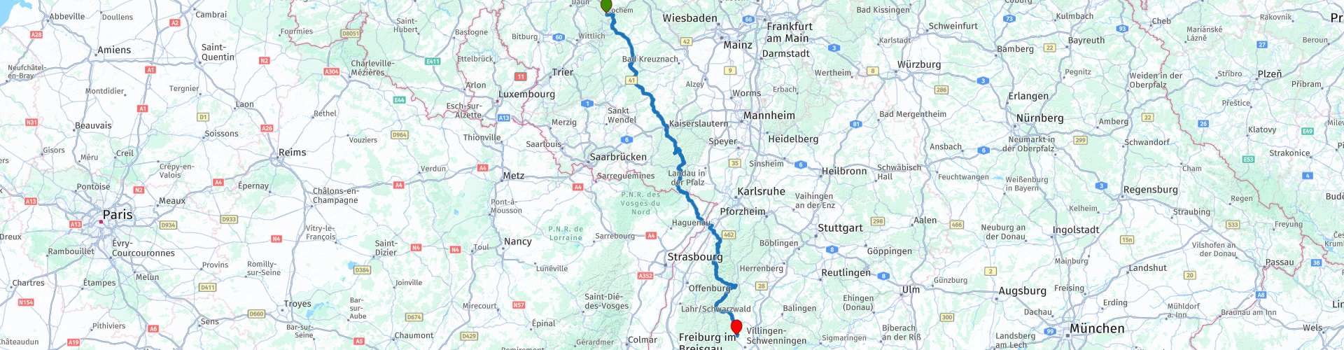
Distance
365.87 km

Countries


 RouteXpert Review
 A beautiful 365-kilometer ride with a mix of provincial and country roads. Lots of beautiful scenery, charming villages, and winding roads, including a short stretch through France.
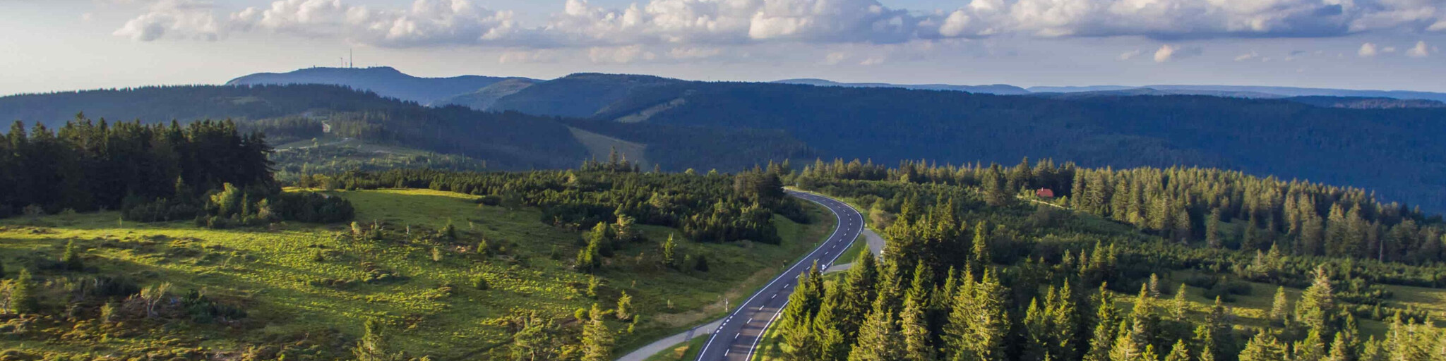
The highlight is the Schwarzwaldhochstraße, also known as the B500. This is the oldest and perhaps the most beautiful route through the Black Forest. It winds up to the summit of the Bühlerhöhe. The road continues along the mountains, with beautiful views towards Freudenstadt on the eastern edge of the forest, all at an altitude of between 800 and 1000 meters.
This 65-kilometer scenic road runs from Baden-Baden through the northern Black Forest to Freudenstadt and is a must-see for any visitor to the Black Forest. Along the way, there are several places to stop and enjoy the views. It gets very busy on weekends, so allow extra travel time. Also, mind your speed, as there are frequent speed checks.
You can stop at the Mummelsee for a drink and enjoy the view over the Mummelsee.
The final destination is the Schwarzwald Parkhotel, a large hotel with annexes where you can also rent rooms. Some also have kitchenettes, but unfortunately, there's no air conditioning, so it can get hot. It's beautifully situated and has a pleasant terrace with a good restaurant and a very extensive breakfast.


 Links
Links  Usage
Usage Want to download this route?
You can download the route for free without MyRoute-app account. To do so, open the route and click 'save as'. Want to edit this route?
No problem, start by opening the route. Follow the tutorial and create your personal MyRoute-app account. After registration, your trial starts automatically.  Disclaimer
Use of this GPS route is at your own expense and risk. The route has been carefully composed and checked by a MyRoute-app accredited RouteXpert for use on TomTom, Garmin and MyRoute-app Navigation.
Changes may nevertheless have occurred due to changed circumstances, road diversions or seasonal closures. We therefore recommend checking each route before use.
Preferably use the route track in your navigation system. More information about the use of MyRoute-app can be found on the website under 'Community' or 'Academy'.

Hunsrück
About this region
The Hunsrück (German pronunciation: [ˈhʊnsʁʏk]) is a long, triangular, pronounced upland in Rhineland-Palatinate, Germany. It is bounded by the valleys of the Moselle-Saar (north-to-west), the Nahe (south), and the Rhine (east). It is continued by the Taunus mountains, past the Rhine and by the Eifel past the Moselle. To the south of the Nahe is a lower, hilly country forming the near bulk of the Palatinate region and all of the, smaller, Saarland. Below its north-east corner is Koblenz.
As the Hunsrück proceeds east it acquires north-south width and three notable gaps in its southern ridges. In this zone are multi-branch headwaters including the Simmerbach ending at Simmertal on the southern edge. This interior is therefore rarely higher than 450 metres (1,480 ft) above sea level. Peaks and escarpments are principally: the (Black Forest) Hochwald, the Idar Forest, the Soonwald, and the Bingen Forest. The highest mountain is the Erbeskopf (816 m; 2,677 ft), towards the region's south-west.
Notable towns are Simmern, Kirchberg, and Idar-Oberstein, Kastellaun, and Morbach. Frankfurt-Hahn Airport is at the centre of the upland, equidistant between Mainz, Trier and Koblenz, co-named after the village of Hahn.
Slate is still mined in the mountains. Since 2010, the region has become one of Germany's major onshore wind power regions. Large wind farms are near Ellern and Kirchberg. Nature-based tourism is widespread. In 2015, a new national park was inaugurated. The pedestrian Geierlay suspension bridge opened in the same year. The climate sees mists that rise most mornings. More rain than the German average is caused by a combination of an oceanic influence and relief precipitation.
Culturally, the region is best known for its Hunsrückisch dialect and through depictions in the Heimat film series. The region saw great emigration in the mid-19th century, particularly to Brazil.
Read more on Wikipedia
As the Hunsrück proceeds east it acquires north-south width and three notable gaps in its southern ridges. In this zone are multi-branch headwaters including the Simmerbach ending at Simmertal on the southern edge. This interior is therefore rarely higher than 450 metres (1,480 ft) above sea level. Peaks and escarpments are principally: the (Black Forest) Hochwald, the Idar Forest, the Soonwald, and the Bingen Forest. The highest mountain is the Erbeskopf (816 m; 2,677 ft), towards the region's south-west.
Notable towns are Simmern, Kirchberg, and Idar-Oberstein, Kastellaun, and Morbach. Frankfurt-Hahn Airport is at the centre of the upland, equidistant between Mainz, Trier and Koblenz, co-named after the village of Hahn.
Slate is still mined in the mountains. Since 2010, the region has become one of Germany's major onshore wind power regions. Large wind farms are near Ellern and Kirchberg. Nature-based tourism is widespread. In 2015, a new national park was inaugurated. The pedestrian Geierlay suspension bridge opened in the same year. The climate sees mists that rise most mornings. More rain than the German average is caused by a combination of an oceanic influence and relief precipitation.
Culturally, the region is best known for its Hunsrückisch dialect and through depictions in the Heimat film series. The region saw great emigration in the mid-19th century, particularly to Brazil.
View region
 Statistics
  65
65Amount of RX reviews (Hunsrück)
 17462
17462Amount of visitors (Hunsrück)
 11210
11210Amount of downloads (Hunsrück)
 Route Collections in this region
 11 day trip from the Netherlands
8 countries in 11 days; The Netherlands, Germany, Austria, Italy, Switzerland, France, Luxembourg and Belgium. This route collections consists of 10 routes that I have driven with friends in the summer of 2019.
The start is in Geldermalsen Netherlands, the first 7 days you drive through the Netherlands, Germany, Austria, Italy, Switzerland, France and a piece of Luxembourg with overnight stays in hotels.
The last three days you stay in Barweiler (D) in the Eifel and you drive two beautiful tours through the Eifel, Luxembourg and parts of the Belgian Ardennes.
There is no highway in the routes, only beautiful provincial and country roads, many beautiful passes with beautiful panoramas.
Be sure to check whether the passes are open before you leave.
These are routes for experienced drivers.
View Route Collection
Route collection hairpins in the Eifel
This collection is composed of the most beautiful and winding roads in the Eifel. Forget Bundesstraßen, forget the road along the Moselle, if you have driven these roads, you can really say that you have been to the Eifel.
No less than 6 routes and 1,800 kilometers are waiting for you!
No less than 6 routes and 1,800 kilometers are waiting for you!
View Route Collection