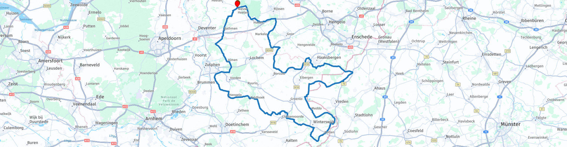
Sploder Motortoertocht 2016 vanuit Nieuw Heeten

This route was brought to you by:
RouteXpert Hans Lamers - RouteXpert
Last edit: 31-03-2025
 Route Summary
 The tour is made, organized and driven by people who live nearby or come from Espelo, a hamlet of the municipality of Holten. Motorcyclists from Holten and Nieuw-Heeten are often part of the party. It is a day trip that is often accompanied by a duo passenger (usually the wife). Every year they try to find a few people who can or want to put together an exciting route.
The meeting point and start of the route is at Café Vree-Egberts in Nieuw-Heeten.
This route was driven on 19-06-2016.
The route gets 4 stars and is compatible with Garmin, TomTom, Open streetmaps and Navigation next.
 Share this route


Animation

Verdict


Duration
6h 12m

Mode of travel
Car or motorcycle

Distance
218.67 km

Countries


 RouteXpert Review
 You start the engine and feel the familiar vibrations under your hands. The air is fresh, the road ahead of you is smooth, and the club members of MC Freewheels, motorcyclists from Espelo(splo) and the surrounding area gather in Nieuw-Heeten at Café Vree-Egberts. The annual touring event is about to begin. Today you will ride a beautiful route through Twente, the Achterhoek and even a bit of Germany. The goal: a wonderful ride and a special activity.
With the growling sound of multiple engines around you, you set off. The group rides in a flowing formation, enjoying the winding roads and the landscape that glides by. Small villages, vast meadows and atmospheric forests alternate. You feel the freedom of motorcycling on every meter of the road.
A special moment during the ride is the stop at the Monument for the raid of October 14, 1944. You read about the dramatic events from the Second World War and decide to get off and follow the path to the left of the monument. After about 500 meters, a sign points you to a hiding place, hidden in the woods near Holten. At the time, people were hiding here to escape the Arbeitseinsatz. The realization of this history makes an impression and gives an extra dimension to the ride.
After this impressive stop you continue driving and come through the picturesque Diepenheim. This town on the Regge, one of the eight medieval towns of Twente, is known for its castles, manors and beautiful gardens. The atmosphere breathes history and art. A short break here is a welcome break to take in the beauty of the surroundings.
The route takes you further along Selvink Molen, a recreation park that is worth a visit. The park offers a camping site, a Burgundian grill restaurant and a play paradise. The old mill from 1866, a national monument, towers proudly above the park. Enjoying a pancake or a cup of coffee in this environment makes the ride even more special.
The second part of the ride takes you past a historical site from World War II: the V1 launch site at Joppe. Although only a small part of the launch track is visible, an information board provides some explanation about the V1 rockets that were launched here. It reminds you how this region was once in the grip of war and technology.
During the rest of the route you will pass various places where you can stop for a cup of coffee or a nice photo. The kilometers glide by while the sun slowly sets. When you finally return to Nieuw-Heeten, you feel the satisfaction of a successful day. The ride, the impressive stops and the togetherness with the club have made this tour an unforgettable adventure.
You turn off your engine, look around again and know: you'll be there again next year.


 Links
Links  Usage
Usage Want to download this route?
You can download the route for free without MyRoute-app account. To do so, open the route and click 'save as'. Want to edit this route?
No problem, start by opening the route. Follow the tutorial and create your personal MyRoute-app account. After registration, your trial starts automatically.  Disclaimer
Use of this GPS route is at your own expense and risk. The route has been carefully composed and checked by a MyRoute-app accredited RouteXpert for use on TomTom, Garmin and MyRoute-app Navigation.
Changes may nevertheless have occurred due to changed circumstances, road diversions or seasonal closures. We therefore recommend checking each route before use.
Preferably use the route track in your navigation system. More information about the use of MyRoute-app can be found on the website under 'Community' or 'Academy'.

North Rhine-Westphalia
About this region
North Rhine-Westphalia (German: Nordrhein-Westfalen, pronounced [ˌnɔʁtʁaɪn vɛstˈfaːlən] (listen); Low Franconian: Noordrien-Wesfale; Low German: Noordrhien-Westfalen; Colognian: Noodrhing-Wäßßfaale), commonly shortened to NRW (German: [ɛnʔɛʁˈveː] (listen)), is a German state (Land) in Western Germany. With more than 17.9 million inhabitants, it is the most populous state of Germany. Covering an area of 34,084 square kilometres (13,160 sq mi), it is the fourth-largest German state by size. Apart from the city-states, it is also the most densely populated state in Germany.
North Rhine-Westphalia features 30 of the 81 German municipalities with over 100,000 inhabitants, including Cologne (over 1 million), the state capital Düsseldorf, Dortmund and Essen (all about 600,000 inhabitants) and other cities predominantly located in the Rhine-Ruhr metropolitan area, the largest urban area in Germany and the third-largest on the European continent. The location of the Rhine-Ruhr at the heart of the European Blue Banana makes it well connected to other major European cities and metropolitan areas like the Randstad, the Flemish Diamond and the Frankfurt Rhine-Main Region.
North Rhine-Westphalia was established in 1946 after World War II from the Prussian provinces of Westphalia and the northern part of Rhine Province (North Rhine), and the Free State of Lippe by the British military administration in Allied-occupied Germany and became a state of the Federal Republic of Germany in 1949. The city of Bonn served as the federal capital until the reunification of Germany in 1990 and as the seat of government until 1999.
Culturally, North Rhine-Westphalia is not a uniform area; there are significant differences, especially in traditional customs, between the Rhineland region on the one hand and the regions of Westphalia and Lippe on the other. The state has always been Germany's powerhouse with the largest economy among the German states by GDP figures.
Read more on Wikipedia
North Rhine-Westphalia features 30 of the 81 German municipalities with over 100,000 inhabitants, including Cologne (over 1 million), the state capital Düsseldorf, Dortmund and Essen (all about 600,000 inhabitants) and other cities predominantly located in the Rhine-Ruhr metropolitan area, the largest urban area in Germany and the third-largest on the European continent. The location of the Rhine-Ruhr at the heart of the European Blue Banana makes it well connected to other major European cities and metropolitan areas like the Randstad, the Flemish Diamond and the Frankfurt Rhine-Main Region.
North Rhine-Westphalia was established in 1946 after World War II from the Prussian provinces of Westphalia and the northern part of Rhine Province (North Rhine), and the Free State of Lippe by the British military administration in Allied-occupied Germany and became a state of the Federal Republic of Germany in 1949. The city of Bonn served as the federal capital until the reunification of Germany in 1990 and as the seat of government until 1999.
Culturally, North Rhine-Westphalia is not a uniform area; there are significant differences, especially in traditional customs, between the Rhineland region on the one hand and the regions of Westphalia and Lippe on the other. The state has always been Germany's powerhouse with the largest economy among the German states by GDP figures.
View region
 Statistics
  140
140Amount of RX reviews (North Rhine-Westphalia)
 79270
79270Amount of visitors (North Rhine-Westphalia)
 34156
34156Amount of downloads (North Rhine-Westphalia)
 Route Collections in this region
 The 10 most beautiful car and motorcycle routes in Limburg
Limburg, who thinks of Limburg, thinks of flan, coal mines, marl and the hill country. The coal mines have been closed for almost 40 years, the last load of coal was brought up from the Oranje-Nassau coal mine in Heerlen on 31 December and, as they say, South Limburg was transformed from Black to Green and unfortunately there is still little left. view of this period.
But not only pie, marl and coal in Limburg, but also a very beautiful province to tour by car or motorcycle and enjoy all the beauty that the province of Limburg has to offer. For this, the MyRoute app RouteXpert has put together a Top 10 of Car and Motorcycle routes for you.
All routes in this collection have been checked and made equal for TomTom, Garmin and MyRoute-app Navigation by a MyRoute-app RouteXpert.
If you think, I have a very nice route that should certainly not be missing from this collection, send it to:
email: routeexpert@myrouteapp.com
Subject: New Route for the Top 10 collection Province of Limburg composed by Hans van de Ven.
The route will then be reviewed and then added to the Top 10.
To make the Top 10 also the Top 10, 1 route will have to disappear from the Top 10, you can indicate this when submitting the new route.
Have fun with this collection and while driving one of these routes. Enjoy all the beauty that the Netherlands and in particular the province of Limburg has to offer. Click on “View route” to read the review of the chosen route.
I would like to hear your findings about the route(s).
View Route Collection
Top 5 Car and Motorcycle Routes in the Eifel
The Eifel is the eastern part of the medium plateau Eifel-Ardennes. It is located north of the Moselle and west of the Rhine. The largest part is in Germany, a small part is in Belgium, in the East Cantons. The German part of Eifel is located in the federal states of North Rhine-Westphalia and Rhineland-Palatinate. The highest point is the Hohe Acht with 747 meters.
Several chains can be distinguished in the Eifel:
The northernmost part is called the Nordeifel, which in Belgium connects to the High Fens;
To the east of this is the Ahrgebirge, this part is located north of the Ahr in the Ahrweiler district;
South of the Ahr is the Hohe Eifel (or Hocheifel), of which the Hohe Acht (747 m) is the highest point, and also the highest point in the entire Eifel region;
To the west, near the Belgian border, the hills are known as Schneifel, part of the wider Snow Eifel area with peaks reaching up to 698 metres;
South and east of the Hohe Eifel is the Volcano-Eifel, a volcanic area with many crater lakes (Maare).
The southern part of the Eifel is less high. The area is bisected by streams and rivers running southwards. These streams flow into the Moselle. The largest of these rivers is the Kyll; the hills around this river are known as the Kyllwald;
In the south, the Eifel ends in the Voreifel.
In the north of the Eifel there are some large reservoirs. The largest of these is the reservoir in the Roer that was created by the construction of the Roerdal dam.
The Nürburgring is also located in the Eifel, a well-known car circuit for Formula 1 races, among other things. Since 2004, part of the north of the Eifel has become the Eifel National Park. This National Park falls entirely within the German-Belgian nature park High Fens-Eifel. Another part of the Eifel falls within the South Eifel Nature Park.
Well-known throughout the Netherlands and Belgium by car and motorcyclists, so reason enough for the MyRoute app RouteXpert to compile a Top 5 of Car and Motorbike routes for you.
All routes in this collection have been checked and made equal for TomTom, Garmin and MyRoute-app Navigation by a MyRoute-app RouteXpert.
If you think, I have a very nice route that should certainly not be missing from this collection, send it to:
email: routeexpert@myrouteapp.com
Subject: New Route for the Top 5 collection Eifel composed by Hans van de Ven.
The route will then be reviewed and then added to the Top 5. To make the Top 5 also the Top 5, 1 route will have to disappear from the Top 5, you can indicate this when submitting the new route.
Have fun with this collection and while driving one of these routes. Enjoy all the beauty that the Eifel has to offer. Click on “View route” to read the review of the chosen route.
I would like to hear your findings about the route(s).
View Route Collection