30 Hamelandroute

This route was brought to you by:
RouteXpert Hans van de Ven (Mr.MRA)
Last edit: 28-06-2025
 Route Summary
 This is the 30th in a series of 43 Endangered ANWB routes. These were published in the Promotors between April 2015 and September 2016.
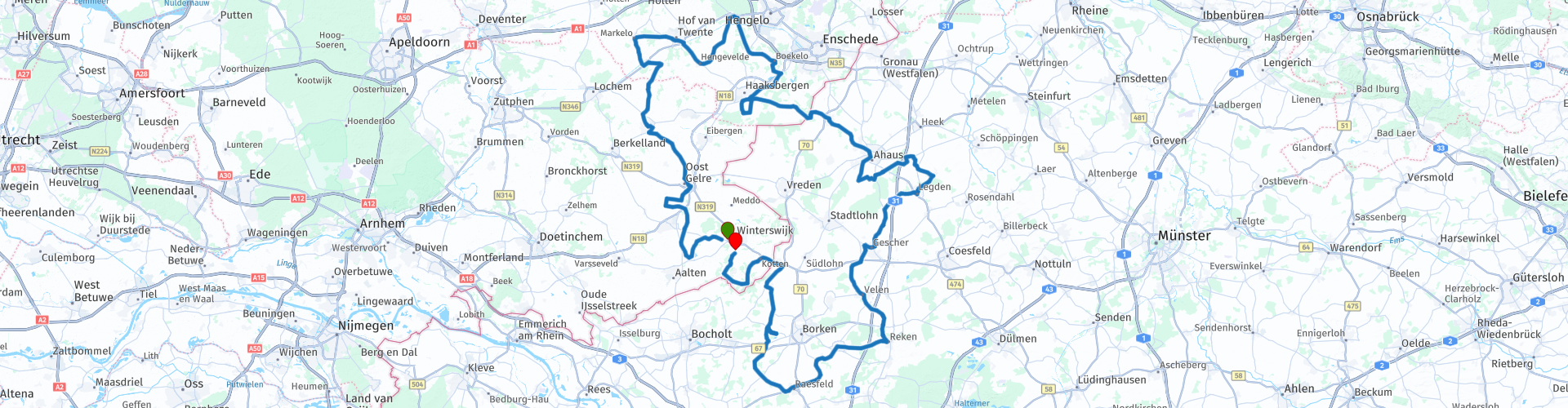
Starting point: Esso, Winterswijk
End point: The Gulle Smid, Winterswijk Woold
I give this route 3 ★★★ stars because of the beautiful, quiet Achterhoek and cross-border roads, the varied coulisse landscape and the wealth of historic towns and villages that each tell a story. The road surface is good, the catering along the way excellent and the border area with Germany gives the ride an international touch.
 Share this route


Animation

Verdict


Duration
6h 51m

Mode of travel
Car or motorcycle

Distance
260.86 km

Countries


 RouteXpert Review
 The route starts at the Esso in Winterswijk. This petrol station offers modern facilities and fuels from Synergy Diesel to Premium petrol. Handy to start your journey well. After a short stretch of city, you immediately dive into the Achterhoek countryside. Here the roads meander between meadows, hedgerows and farms. The first highlight is not long in coming: Bredevoort. This atmospheric fortified town, famous as a book town, breathes history. Feel free to stroll around between the books, mills and old streets. The road winds further to Groenlo, where the cannons were used during the Eighty Years' War. The city walls, canals and bastions remind you of how strategically important this town once was. And of course, when you think of Grolsch, you immediately think of beer. Then you drive via Beltrum and Borculo. In Borculo you discover a city with medieval roots and stories about castles, mills and war. Here you can taste the Achterhoek culture, literally and figuratively. You drive north along narrow farm roads towards Goor, Goor tells a different story: once a swamp, later a textile town and now a town full of small museums and a vibrant folk festival.
The ride heads east and slowly crosses the border with Germany. There you will find a culinary rest stop; Spoolder in Bentelo or, a little further across the border, Gaststätte Voss near Ahaus. Spoolder is a typical Achterhoek restaurant with lunch, dinner and artisanal ice cream, while Voss stands for traditional Westphalian hospitality. Of course you can also stop at both.
In Germany you will pass the charming town of Ahaus, known for its baroque castle and cozy center. Further on the route takes you through beautiful Münsterland roads, Reken, where mills, wildlife parks and green forests fill the horizon. The engine hums softly as you drive back towards the Netherlands. After a beautiful border crossing, a fuel stop awaits you at Hoitink Wind Brandstoffen, a family-run gas station near Winterswijk. The last kilometers take you through the Woold back to Winterswijk. You end at De Gulle Smid, an atmospheric family restaurant where they serve home-smoked ham, salmon and vegetarian dishes. An ideal place for a final drink or dinner.
The Hamelandroute is a motorcycle tour for those who really want to discover the border area. Quiet roads, historic towns and fine restaurants make this a ride that you should ride quietly and with full gusto. Here you can feel how the Netherlands and Germany merge into each other - a unique ride that you would like to ride again.
Suggested Break, Info, Fuel and Viewpoints included in the route
• TSP – Tour Start Point; Esso, Modern gas station with long opening hours and good facilities for a fresh start.
• TIP – Tour Info Point; Bredevoort, Atmospheric fortified town, known as a book town, full of historic streets and mills.
• TIP – Tour Info Point; Groenlo, fortified town with a rich history from the Eighty Years' War and birthplace of Grolsch.
• TIP – Tour Info Point; Borculo, Historic town with watermills, old canals and traces of WWII.
• TIP – Tour Info Point; Goor, a Twente city with a textile past, museums and a lively village centre.
• TPP – Tour Pauze Punt; Spoolder, Atmospheric café with lunch, dinner and artisanal ice cream in Bentelo.
• TPP – Tour Pauze Punt; Gaststätte Voss, Westphalian hospitality with fresh dishes of the day, camper space also available.
• TIP – Tour Info Point; Ahaus, German town with baroque castle and pleasant centre.
• TIP – Tour Info Point; Reken, Village between Münster and the Ruhr area, known for its nature park and mills.
• TBP – Tour Fuel Point; Hoitink Wind Fuels, Family petrol station with long opening hours and LPG.
• TEP – Tour End Point; De Gulle Smid, Cosy family restaurant with honest cuisine, perfect to end the tour.


 Links
Links  Usage
Usage Want to download this route?
You can download the route for free without MyRoute-app account. To do so, open the route and click 'save as'. Want to edit this route?
No problem, start by opening the route. Follow the tutorial and create your personal MyRoute-app account. After registration, your trial starts automatically.  Disclaimer
Use of this GPS route is at your own expense and risk. The route has been carefully composed and checked by a MyRoute-app accredited RouteXpert for use on TomTom, Garmin and MyRoute-app Navigation.
Changes may nevertheless have occurred due to changed circumstances, road diversions or seasonal closures. We therefore recommend checking each route before use.
Preferably use the route track in your navigation system. More information about the use of MyRoute-app can be found on the website under 'Community' or 'Academy'.

North Rhine-Westphalia
About this region
North Rhine-Westphalia (German: Nordrhein-Westfalen, pronounced [ˌnɔʁtʁaɪn vɛstˈfaːlən] (listen); Low Franconian: Noordrien-Wesfale; Low German: Noordrhien-Westfalen; Colognian: Noodrhing-Wäßßfaale), commonly shortened to NRW (German: [ɛnʔɛʁˈveː] (listen)), is a German state (Land) in Western Germany. With more than 17.9 million inhabitants, it is the most populous state of Germany. Covering an area of 34,084 square kilometres (13,160 sq mi), it is the fourth-largest German state by size. Apart from the city-states, it is also the most densely populated state in Germany.
North Rhine-Westphalia features 30 of the 81 German municipalities with over 100,000 inhabitants, including Cologne (over 1 million), the state capital Düsseldorf, Dortmund and Essen (all about 600,000 inhabitants) and other cities predominantly located in the Rhine-Ruhr metropolitan area, the largest urban area in Germany and the third-largest on the European continent. The location of the Rhine-Ruhr at the heart of the European Blue Banana makes it well connected to other major European cities and metropolitan areas like the Randstad, the Flemish Diamond and the Frankfurt Rhine-Main Region.
North Rhine-Westphalia was established in 1946 after World War II from the Prussian provinces of Westphalia and the northern part of Rhine Province (North Rhine), and the Free State of Lippe by the British military administration in Allied-occupied Germany and became a state of the Federal Republic of Germany in 1949. The city of Bonn served as the federal capital until the reunification of Germany in 1990 and as the seat of government until 1999.
Culturally, North Rhine-Westphalia is not a uniform area; there are significant differences, especially in traditional customs, between the Rhineland region on the one hand and the regions of Westphalia and Lippe on the other. The state has always been Germany's powerhouse with the largest economy among the German states by GDP figures.
Read more on Wikipedia
North Rhine-Westphalia features 30 of the 81 German municipalities with over 100,000 inhabitants, including Cologne (over 1 million), the state capital Düsseldorf, Dortmund and Essen (all about 600,000 inhabitants) and other cities predominantly located in the Rhine-Ruhr metropolitan area, the largest urban area in Germany and the third-largest on the European continent. The location of the Rhine-Ruhr at the heart of the European Blue Banana makes it well connected to other major European cities and metropolitan areas like the Randstad, the Flemish Diamond and the Frankfurt Rhine-Main Region.
North Rhine-Westphalia was established in 1946 after World War II from the Prussian provinces of Westphalia and the northern part of Rhine Province (North Rhine), and the Free State of Lippe by the British military administration in Allied-occupied Germany and became a state of the Federal Republic of Germany in 1949. The city of Bonn served as the federal capital until the reunification of Germany in 1990 and as the seat of government until 1999.
Culturally, North Rhine-Westphalia is not a uniform area; there are significant differences, especially in traditional customs, between the Rhineland region on the one hand and the regions of Westphalia and Lippe on the other. The state has always been Germany's powerhouse with the largest economy among the German states by GDP figures.
View region
 Statistics
  136
136Amount of RX reviews (North Rhine-Westphalia)
 67441
67441Amount of visitors (North Rhine-Westphalia)
 30413
30413Amount of downloads (North Rhine-Westphalia)
 Route Collections in this region
 The 10 most beautiful car and motorcycle routes in Limburg
Limburg, who thinks of Limburg, thinks of flan, coal mines, marl and the hill country. The coal mines have been closed for almost 40 years, the last load of coal was brought up from the Oranje-Nassau coal mine in Heerlen on 31 December and, as they say, South Limburg was transformed from Black to Green and unfortunately there is still little left. view of this period.
But not only pie, marl and coal in Limburg, but also a very beautiful province to tour by car or motorcycle and enjoy all the beauty that the province of Limburg has to offer. For this, the MyRoute app RouteXpert has put together a Top 10 of Car and Motorcycle routes for you.
All routes in this collection have been checked and made equal for TomTom, Garmin and MyRoute-app Navigation by a MyRoute-app RouteXpert.
If you think, I have a very nice route that should certainly not be missing from this collection, send it to:
email: routeexpert@myrouteapp.com
Subject: New Route for the Top 10 collection Province of Limburg composed by Hans van de Ven.
The route will then be reviewed and then added to the Top 10.
To make the Top 10 also the Top 10, 1 route will have to disappear from the Top 10, you can indicate this when submitting the new route.
Have fun with this collection and while driving one of these routes. Enjoy all the beauty that the Netherlands and in particular the province of Limburg has to offer. Click on “View route” to read the review of the chosen route.
I would like to hear your findings about the route(s).
View Route Collection
Top 5 Car and Motorcycle Routes in the Eifel
The Eifel is the eastern part of the medium plateau Eifel-Ardennes. It is located north of the Moselle and west of the Rhine. The largest part is in Germany, a small part is in Belgium, in the East Cantons. The German part of Eifel is located in the federal states of North Rhine-Westphalia and Rhineland-Palatinate. The highest point is the Hohe Acht with 747 meters.
Several chains can be distinguished in the Eifel:
The northernmost part is called the Nordeifel, which in Belgium connects to the High Fens;
To the east of this is the Ahrgebirge, this part is located north of the Ahr in the Ahrweiler district;
South of the Ahr is the Hohe Eifel (or Hocheifel), of which the Hohe Acht (747 m) is the highest point, and also the highest point in the entire Eifel region;
To the west, near the Belgian border, the hills are known as Schneifel, part of the wider Snow Eifel area with peaks reaching up to 698 metres;
South and east of the Hohe Eifel is the Volcano-Eifel, a volcanic area with many crater lakes (Maare).
The southern part of the Eifel is less high. The area is bisected by streams and rivers running southwards. These streams flow into the Moselle. The largest of these rivers is the Kyll; the hills around this river are known as the Kyllwald;
In the south, the Eifel ends in the Voreifel.
In the north of the Eifel there are some large reservoirs. The largest of these is the reservoir in the Roer that was created by the construction of the Roerdal dam.
The Nürburgring is also located in the Eifel, a well-known car circuit for Formula 1 races, among other things. Since 2004, part of the north of the Eifel has become the Eifel National Park. This National Park falls entirely within the German-Belgian nature park High Fens-Eifel. Another part of the Eifel falls within the South Eifel Nature Park.
Well-known throughout the Netherlands and Belgium by car and motorcyclists, so reason enough for the MyRoute app RouteXpert to compile a Top 5 of Car and Motorbike routes for you.
All routes in this collection have been checked and made equal for TomTom, Garmin and MyRoute-app Navigation by a MyRoute-app RouteXpert.
If you think, I have a very nice route that should certainly not be missing from this collection, send it to:
email: routeexpert@myrouteapp.com
Subject: New Route for the Top 5 collection Eifel composed by Hans van de Ven.
The route will then be reviewed and then added to the Top 5. To make the Top 5 also the Top 5, 1 route will have to disappear from the Top 5, you can indicate this when submitting the new route.
Have fun with this collection and while driving one of these routes. Enjoy all the beauty that the Eifel has to offer. Click on “View route” to read the review of the chosen route.
I would like to hear your findings about the route(s).
View Route Collection