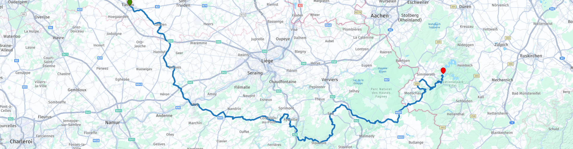
Tienen to Rurberg

This route was brought to you by:
RouteXpert Guy Heyns - Adv. RouteXpert
Last edit: 10-12-2024
 Route Summary
 You also cross 3 very important Ardennes rivers (Maas, Ourthe & Amblève) that are part of the Ardennes development.
It is a very winding route towards the Eifel. There are sufficient rest points so that the novice motorcyclist can easily 'digest' this route, without having to sacrifice cornering pleasure.
 Share this route


Animation

Verdict


Duration
4h 40m

Mode of travel
Car or motorcycle

Distance
203.77 km

Countries


 RouteXpert Review
 The start of the route is on the Veemarkt in sugar city Tienen. De Veemarkt offers ample parking facilities and 'Meet & Greet' places such as 'Den Aflaat' and 'Het Wiel'. If everyone arrives with a full tank, from RP3 you immediately dive into the nice and beautiful village centers. However, if there is still to be refueled, you can just drive straight ahead on RP3 and you will see three filling stations in quick succession. If you turn back to the right at the Total, you will immediately return to the route and you can continue to enjoy the beautiful rural Brabant field and village roads. Moreover, with good quality. In the Walloon part of the country you will notice some quality difference, especially compared to the German roads, but that makes the exercise all the more interesting for the novice motorcyclist.
You leave Flanders at route point 7. This means, among other things, that the speed limit on secondary roads outside the village centers will go from 70 km / h to 90. Interesting to know!
At route point 12 you will pass the Maas, a very important river for both Belgium and the Netherlands, after which you quickly arrive in Huy, a fairly touristic city on the banks of this river. If desired, you can take a short break here and the marketplace is certainly recommended. There are many opportunities to take a break here. Please note that you cannot park the motorcycle close to and in plain sight and that it can also be a bit busier in Huy, especially on a sunny day off. A (more pleasant) alternative is the thirty kilometers away Comblain-au-Pont, which is still within the limits of an acceptable break interval. Just before Comblain-au-Pont you will see your first 'pin' and this will happen regularly from now on.
In Comblain-au-Pont (RP21) you are on the banks of the Ourthe, a fairly well-known and tourist-developed river that attracts many tourists to the Ardennes. Both 'Le Dilemme' and 'Belle Vue' are pleasant places to take a break and parking is nearby. In any case, it will be less crowded than in Huy and you can also keep an eye on the motorcycles, which is no unnecessary luxury in the Ardennes ...
On RP25, just after Comblain-au-Pont, you pass the river 'Amblève' for the first time. Together with the Ourthe, the Amblève is also a strong attraction for Ardennes tourism.
From now on the route becomes more and more curvy and more beautiful and the route takes you through the world famous Spa (RP33) via these beautiful sliding roads. The village indeed where the 'Spa Bruis' (and many other waters) come from. Optionally you can take a break here, but watch out for the crowds in this town. It can literally run over there…, but a visit, and certainly one of the sources, is certainly recommended. You can then later, at each visit to the drinks department of the supermarket, think back to this short journey… You pass two famous sources of Spa (Barisart & Géronstère) just after RP32.
If it is too busy in Spa itself (very well possible), you will find a pleasant and much quieter stop at RP36 with ample parking space. Hotel restaurant 'Beau Site' or café 'Ardennais' are both highly recommended.
From then on you drive in one go to the hotel Paulushof on the Rursee. You will first pass the Belgian-German border at RP39 and from then on you can taste the legendary German road quality and design. Tasty curves slide under your wheels in the best possible conditions. So enjoy the last 25 kilometers that bring you to hotel Paulushof on the edge of the Rursee.
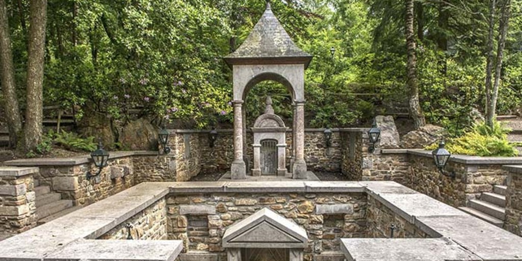
Hotel Paulushof (Route end point - RP40) is a simple but somewhat dated hotel, but it is neat and the location on the Rursee is ideal, especially if you also like some peripheral activities. Walking, boating, possibly cycling or a tourist visit, it is all possible in this region. The hotel itself also has swimming pool and sauna facilities that you can use for free. The restaurant is simple, but more than adequate and delicious. Unfortunately, the hotel does not have a covered car park, but it is separated from the road.
In the route links you will also find some further information about the Rursee itself and its importance for this region.
The route is fun to drive, for both the novice and the experienced motorcyclist. Your light technical skills will be addressed on this relaxing, beautiful ride in a pleasant and increasingly beautiful environment. Precisely because of this combination of beauty, road quality, relaxing and yet slightly technical character, we give this route a 5-star rating. Yes, there may be more beautiful and technically more challenging routes to be found, but it is precisely the combination of all this that gives it added value, along with the possibility to do other things on this mini-trip.
The continuation of this first route of this triptych can be found in the route '60 bends in the Eifel ', a very technical route in which 60 hairpin bends become your part in this very fascinating region.

 Links
Links  Usage
Usage Want to download this route?
You can download the route for free without MyRoute-app account. To do so, open the route and click 'save as'. Want to edit this route?
No problem, start by opening the route. Follow the tutorial and create your personal MyRoute-app account. After registration, your trial starts automatically.  Disclaimer
Use of this GPS route is at your own expense and risk. The route has been carefully composed and checked by a MyRoute-app accredited RouteXpert for use on TomTom, Garmin and MyRoute-app Navigation.
Changes may nevertheless have occurred due to changed circumstances, road diversions or seasonal closures. We therefore recommend checking each route before use.
Preferably use the route track in your navigation system. More information about the use of MyRoute-app can be found on the website under 'Community' or 'Academy'.

North Rhine-Westphalia
About this region
North Rhine-Westphalia (German: Nordrhein-Westfalen, pronounced [ˌnɔʁtʁaɪn vɛstˈfaːlən] (listen); Low Franconian: Noordrien-Wesfale; Low German: Noordrhien-Westfalen; Colognian: Noodrhing-Wäßßfaale), commonly shortened to NRW (German: [ɛnʔɛʁˈveː] (listen)), is a German state (Land) in Western Germany. With more than 17.9 million inhabitants, it is the most populous state of Germany. Covering an area of 34,084 square kilometres (13,160 sq mi), it is the fourth-largest German state by size. Apart from the city-states, it is also the most densely populated state in Germany.
North Rhine-Westphalia features 30 of the 81 German municipalities with over 100,000 inhabitants, including Cologne (over 1 million), the state capital Düsseldorf, Dortmund and Essen (all about 600,000 inhabitants) and other cities predominantly located in the Rhine-Ruhr metropolitan area, the largest urban area in Germany and the third-largest on the European continent. The location of the Rhine-Ruhr at the heart of the European Blue Banana makes it well connected to other major European cities and metropolitan areas like the Randstad, the Flemish Diamond and the Frankfurt Rhine-Main Region.
North Rhine-Westphalia was established in 1946 after World War II from the Prussian provinces of Westphalia and the northern part of Rhine Province (North Rhine), and the Free State of Lippe by the British military administration in Allied-occupied Germany and became a state of the Federal Republic of Germany in 1949. The city of Bonn served as the federal capital until the reunification of Germany in 1990 and as the seat of government until 1999.
Culturally, North Rhine-Westphalia is not a uniform area; there are significant differences, especially in traditional customs, between the Rhineland region on the one hand and the regions of Westphalia and Lippe on the other. The state has always been Germany's powerhouse with the largest economy among the German states by GDP figures.
Read more on Wikipedia
North Rhine-Westphalia features 30 of the 81 German municipalities with over 100,000 inhabitants, including Cologne (over 1 million), the state capital Düsseldorf, Dortmund and Essen (all about 600,000 inhabitants) and other cities predominantly located in the Rhine-Ruhr metropolitan area, the largest urban area in Germany and the third-largest on the European continent. The location of the Rhine-Ruhr at the heart of the European Blue Banana makes it well connected to other major European cities and metropolitan areas like the Randstad, the Flemish Diamond and the Frankfurt Rhine-Main Region.
North Rhine-Westphalia was established in 1946 after World War II from the Prussian provinces of Westphalia and the northern part of Rhine Province (North Rhine), and the Free State of Lippe by the British military administration in Allied-occupied Germany and became a state of the Federal Republic of Germany in 1949. The city of Bonn served as the federal capital until the reunification of Germany in 1990 and as the seat of government until 1999.
Culturally, North Rhine-Westphalia is not a uniform area; there are significant differences, especially in traditional customs, between the Rhineland region on the one hand and the regions of Westphalia and Lippe on the other. The state has always been Germany's powerhouse with the largest economy among the German states by GDP figures.
View region
 Statistics
  136
136Amount of RX reviews (North Rhine-Westphalia)
 62775
62775Amount of visitors (North Rhine-Westphalia)
 28350
28350Amount of downloads (North Rhine-Westphalia)
 Route Collections in this region
 The 10 most beautiful car and motorcycle routes in Limburg
Limburg, who thinks of Limburg, thinks of flan, coal mines, marl and the hill country. The coal mines have been closed for almost 40 years, the last load of coal was brought up from the Oranje-Nassau coal mine in Heerlen on 31 December and, as they say, South Limburg was transformed from Black to Green and unfortunately there is still little left. view of this period.
But not only pie, marl and coal in Limburg, but also a very beautiful province to tour by car or motorcycle and enjoy all the beauty that the province of Limburg has to offer. For this, the MyRoute app RouteXpert has put together a Top 10 of Car and Motorcycle routes for you.
All routes in this collection have been checked and made equal for TomTom, Garmin and MyRoute-app Navigation by a MyRoute-app RouteXpert.
If you think, I have a very nice route that should certainly not be missing from this collection, send it to:
email: routeexpert@myrouteapp.com
Subject: New Route for the Top 10 collection Province of Limburg composed by Hans van de Ven.
The route will then be reviewed and then added to the Top 10.
To make the Top 10 also the Top 10, 1 route will have to disappear from the Top 10, you can indicate this when submitting the new route.
Have fun with this collection and while driving one of these routes. Enjoy all the beauty that the Netherlands and in particular the province of Limburg has to offer. Click on “View route” to read the review of the chosen route.
I would like to hear your findings about the route(s).
View Route Collection
Top 5 Car and Motorcycle Routes in the Eifel
The Eifel is the eastern part of the medium plateau Eifel-Ardennes. It is located north of the Moselle and west of the Rhine. The largest part is in Germany, a small part is in Belgium, in the East Cantons. The German part of Eifel is located in the federal states of North Rhine-Westphalia and Rhineland-Palatinate. The highest point is the Hohe Acht with 747 meters.
Several chains can be distinguished in the Eifel:
The northernmost part is called the Nordeifel, which in Belgium connects to the High Fens;
To the east of this is the Ahrgebirge, this part is located north of the Ahr in the Ahrweiler district;
South of the Ahr is the Hohe Eifel (or Hocheifel), of which the Hohe Acht (747 m) is the highest point, and also the highest point in the entire Eifel region;
To the west, near the Belgian border, the hills are known as Schneifel, part of the wider Snow Eifel area with peaks reaching up to 698 metres;
South and east of the Hohe Eifel is the Volcano-Eifel, a volcanic area with many crater lakes (Maare).
The southern part of the Eifel is less high. The area is bisected by streams and rivers running southwards. These streams flow into the Moselle. The largest of these rivers is the Kyll; the hills around this river are known as the Kyllwald;
In the south, the Eifel ends in the Voreifel.
In the north of the Eifel there are some large reservoirs. The largest of these is the reservoir in the Roer that was created by the construction of the Roerdal dam.
The Nürburgring is also located in the Eifel, a well-known car circuit for Formula 1 races, among other things. Since 2004, part of the north of the Eifel has become the Eifel National Park. This National Park falls entirely within the German-Belgian nature park High Fens-Eifel. Another part of the Eifel falls within the South Eifel Nature Park.
Well-known throughout the Netherlands and Belgium by car and motorcyclists, so reason enough for the MyRoute app RouteXpert to compile a Top 5 of Car and Motorbike routes for you.
All routes in this collection have been checked and made equal for TomTom, Garmin and MyRoute-app Navigation by a MyRoute-app RouteXpert.
If you think, I have a very nice route that should certainly not be missing from this collection, send it to:
email: routeexpert@myrouteapp.com
Subject: New Route for the Top 5 collection Eifel composed by Hans van de Ven.
The route will then be reviewed and then added to the Top 5. To make the Top 5 also the Top 5, 1 route will have to disappear from the Top 5, you can indicate this when submitting the new route.
Have fun with this collection and while driving one of these routes. Enjoy all the beauty that the Eifel has to offer. Click on “View route” to read the review of the chosen route.
I would like to hear your findings about the route(s).
View Route Collection