05B Landhuizen en Kastelen tussen De Steeg en Doornenburg

This route was brought to you by:
RouteXpert Hans van de Ven (Mr.MRA)
Last edit: 28-11-2021
 Route Summary
 These country houses and castles have been used as a framework to plot the beautiful routes, but the routes remain worthwhile even without visiting the described objects. But of course the route has added value if you stop here and there and take a walk. Not all manors and castles are open to visitors, but these can be spotted from the public road or their garden or park is open to visitors.
The route is for the most part on country roads, the busier N-roads and urban areas are avoided as much as possible. The length of the routes has been kept below 175 km, partly because the average speed will not be that high on many 60 km roads.
Almost every province has one or more routes, only in South Holland and the Flevopolders no routes have been set out because there were no country houses and castles that were eligible for this tour due to their location.
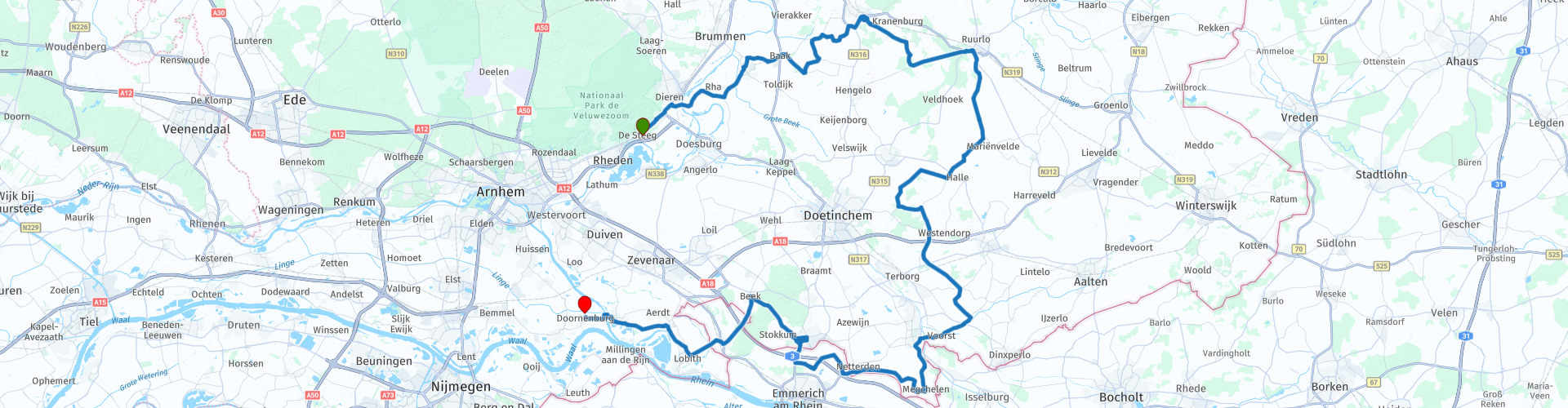
Starting point: Middachten Castle, De Steeg
End point: Doornenburg Castle, Doornenburg
This 4 star route is offered to you by Motorclub Contact Dordrecht.
 Share this route


Animation

Verdict


Duration
6h 42m

Mode of travel
Car or motorcycle

Distance
123.85 km

Countries


 RouteXpert Review
 Middachten Castle, Middachten Estate 3, 6994 JC De Steeg
Castle Middachten is not far from the river IJssel. It is surrounded by the Middachten estate. It is a nationally protected historic country estate with 40 complex numbers. After destruction in 1624 and 1629, it was restored in 1643. The castle got its present form during a major renovation and enlargement in 1694-'97, commissioned by Godard van Reede-Ginkel, Count of Athlone. After the castle was rebuilt in 1698, the construction of the garden started.
The castle was restored in 1967-1971 and is now a hotel restaurant.
Via Steenderen and Baak you arrive at an estate after 16 km.
Estate Baak, Wichmondseweg 19, 7223 LH Baak
Huis Baak is mentioned for the first time in 1294. The house is currently owned by the counts of Gelre. From 1691 it was in the possession of the Van der Heyden family, then after inheritance from 1868 to 1890 in the Van Middachten family, after which it passed, again by inheritance, to the Helmich family, who still own and lease the Baakse forests. In 1738 and 1739 it was rebuilt and renovated by Gerrit Ravenschot from Zutphen, using some wall work from the medieval castle. A farmhouse was added to the estate, among other things. It was also expanded in 1878. The Daughters of Charity Roman Catholic bought the house in 1956 and lived here from 1959 to 1982. The castle has been in the hands of the Roman Catholic Focolare movement since 1982. It served as a Mariapoli for twenty-five years. In 2007 it was sold to the international Christian organization Ellel Ministries.
After some inland roads, after 11 km you are already at the next village Vorden (municipality of Bronckhorst) and there is even a castle with the name of the village (or is it the other way around?).
To see some of the castle you really have to go up the access road.
Vorden Castle, De Horsterkamp 8, 7251 AZ Vorden
Vorden Castle was first mentioned in 1315. The castle was originally a military building, and was inhabited from 1315. In 1580, during the Eighty Years' War, it was looted and restored thirty years later. After the Second World War, the castle stood empty and fell into disrepair. The castle was in a deplorable condition when it came into the possession of Het Geldersch Landschap along with the associated goods and land in 1974. The surrounding land will be sold to the municipality of Vorden. In 1976 it was restored and functioned as the town hall of Vorden. In 2004, the (former) municipality of Vorden sold the castle to private individuals. These have restored the house to its former glory. Since then, the castle has been used as a wedding venue and museum. The castle can be visited for a fee.
Another 12 km further you come to Huize Ruurlo in Ruurlo you guessed it.
Ruurlo Castle, Vordenseweg 2, 7261 LZ Ruurlo
Ruurlo Castle is mentioned as early as 1326 and has been in the hands of the Dutch noble family Van Heeckeren from the 15th century. From the 1980s it served as the town hall of Ruurlo. Due to the merger with Borculo, Eibergen and Neede in 2005, it lost its destination. In 2013, Hans Melchers bought castle and landscape park and had it thoroughly restored. From 2017 it is part of the MORE museum.
After Ruurlo you descend to the southern border of Gelderland and you go through a piece of Germany. After more than 97 kilometers on the route you arrive in 's-Heerenberg.
Castle Huis Bergh, Hof van Bergh 8, 7041 AC 's-Heerenberg
Huis Bergh was the ancestral seat of the Counts of Bergh. The Land van den Bergh was a bannery before 1486 and from 1486 the county of Bergh. Huis Bergh is the largest moated castle in the Netherlands.
After 's-Heerenberg you go in the direction of Beek and then continue a piece of Germany to Lobith and after the ferry over the Pannerdensche canal you are almost at the end point.
Doornenburg Castle, Kerkstraat 27, 6686 BS Doornenburg
Doornenburg Castle is a German castle from the 7th century. It consists of an outer castle and a main castle, which are connected by a narrow wooden bridge. At the end of the Second World War, the castle was almost completely destroyed. It was long thought to have been blown up by the Germans, but it turned out to have been hit by a British bombardment in March 1945. The castle was completely rebuilt from 1947 to 1968. At the end of the 1960s, the castle was used as a film set for the TV series Floris (broadcast 1969) directed by Paul Verhoeven. The lead roles were played by Rutger Hauer and Jos Bergman.


 Links
Links  Usage
Usage Want to download this route?
You can download the route for free without MyRoute-app account. To do so, open the route and click 'save as'. Want to edit this route?
No problem, start by opening the route. Follow the tutorial and create your personal MyRoute-app account. After registration, your trial starts automatically.  Disclaimer
Use of this GPS route is at your own expense and risk. The route has been carefully composed and checked by a MyRoute-app accredited RouteXpert for use on TomTom, Garmin and MyRoute-app Navigation.
Changes may nevertheless have occurred due to changed circumstances, road diversions or seasonal closures. We therefore recommend checking each route before use.
Preferably use the route track in your navigation system. More information about the use of MyRoute-app can be found on the website under 'Community' or 'Academy'.

North Rhine-Westphalia
About this region
North Rhine-Westphalia (German: Nordrhein-Westfalen, pronounced [ˌnɔʁtʁaɪn vɛstˈfaːlən] (listen); Low Franconian: Noordrien-Wesfale; Low German: Noordrhien-Westfalen; Colognian: Noodrhing-Wäßßfaale), commonly shortened to NRW (German: [ɛnʔɛʁˈveː] (listen)), is a German state (Land) in Western Germany. With more than 17.9 million inhabitants, it is the most populous state of Germany. Covering an area of 34,084 square kilometres (13,160 sq mi), it is the fourth-largest German state by size. Apart from the city-states, it is also the most densely populated state in Germany.
North Rhine-Westphalia features 30 of the 81 German municipalities with over 100,000 inhabitants, including Cologne (over 1 million), the state capital Düsseldorf, Dortmund and Essen (all about 600,000 inhabitants) and other cities predominantly located in the Rhine-Ruhr metropolitan area, the largest urban area in Germany and the third-largest on the European continent. The location of the Rhine-Ruhr at the heart of the European Blue Banana makes it well connected to other major European cities and metropolitan areas like the Randstad, the Flemish Diamond and the Frankfurt Rhine-Main Region.
North Rhine-Westphalia was established in 1946 after World War II from the Prussian provinces of Westphalia and the northern part of Rhine Province (North Rhine), and the Free State of Lippe by the British military administration in Allied-occupied Germany and became a state of the Federal Republic of Germany in 1949. The city of Bonn served as the federal capital until the reunification of Germany in 1990 and as the seat of government until 1999.
Culturally, North Rhine-Westphalia is not a uniform area; there are significant differences, especially in traditional customs, between the Rhineland region on the one hand and the regions of Westphalia and Lippe on the other. The state has always been Germany's powerhouse with the largest economy among the German states by GDP figures.
Read more on Wikipedia
North Rhine-Westphalia features 30 of the 81 German municipalities with over 100,000 inhabitants, including Cologne (over 1 million), the state capital Düsseldorf, Dortmund and Essen (all about 600,000 inhabitants) and other cities predominantly located in the Rhine-Ruhr metropolitan area, the largest urban area in Germany and the third-largest on the European continent. The location of the Rhine-Ruhr at the heart of the European Blue Banana makes it well connected to other major European cities and metropolitan areas like the Randstad, the Flemish Diamond and the Frankfurt Rhine-Main Region.
North Rhine-Westphalia was established in 1946 after World War II from the Prussian provinces of Westphalia and the northern part of Rhine Province (North Rhine), and the Free State of Lippe by the British military administration in Allied-occupied Germany and became a state of the Federal Republic of Germany in 1949. The city of Bonn served as the federal capital until the reunification of Germany in 1990 and as the seat of government until 1999.
Culturally, North Rhine-Westphalia is not a uniform area; there are significant differences, especially in traditional customs, between the Rhineland region on the one hand and the regions of Westphalia and Lippe on the other. The state has always been Germany's powerhouse with the largest economy among the German states by GDP figures.
View region
 Statistics
  139
139Amount of RX reviews (North Rhine-Westphalia)
 78454
78454Amount of visitors (North Rhine-Westphalia)
 33726
33726Amount of downloads (North Rhine-Westphalia)
 Route Collections in this region
 The 10 most beautiful car and motorcycle routes in Limburg
Limburg, who thinks of Limburg, thinks of flan, coal mines, marl and the hill country. The coal mines have been closed for almost 40 years, the last load of coal was brought up from the Oranje-Nassau coal mine in Heerlen on 31 December and, as they say, South Limburg was transformed from Black to Green and unfortunately there is still little left. view of this period.
But not only pie, marl and coal in Limburg, but also a very beautiful province to tour by car or motorcycle and enjoy all the beauty that the province of Limburg has to offer. For this, the MyRoute app RouteXpert has put together a Top 10 of Car and Motorcycle routes for you.
All routes in this collection have been checked and made equal for TomTom, Garmin and MyRoute-app Navigation by a MyRoute-app RouteXpert.
If you think, I have a very nice route that should certainly not be missing from this collection, send it to:
email: routeexpert@myrouteapp.com
Subject: New Route for the Top 10 collection Province of Limburg composed by Hans van de Ven.
The route will then be reviewed and then added to the Top 10.
To make the Top 10 also the Top 10, 1 route will have to disappear from the Top 10, you can indicate this when submitting the new route.
Have fun with this collection and while driving one of these routes. Enjoy all the beauty that the Netherlands and in particular the province of Limburg has to offer. Click on “View route” to read the review of the chosen route.
I would like to hear your findings about the route(s).
View Route Collection
Top 5 Car and Motorcycle Routes in the Eifel
The Eifel is the eastern part of the medium plateau Eifel-Ardennes. It is located north of the Moselle and west of the Rhine. The largest part is in Germany, a small part is in Belgium, in the East Cantons. The German part of Eifel is located in the federal states of North Rhine-Westphalia and Rhineland-Palatinate. The highest point is the Hohe Acht with 747 meters.
Several chains can be distinguished in the Eifel:
The northernmost part is called the Nordeifel, which in Belgium connects to the High Fens;
To the east of this is the Ahrgebirge, this part is located north of the Ahr in the Ahrweiler district;
South of the Ahr is the Hohe Eifel (or Hocheifel), of which the Hohe Acht (747 m) is the highest point, and also the highest point in the entire Eifel region;
To the west, near the Belgian border, the hills are known as Schneifel, part of the wider Snow Eifel area with peaks reaching up to 698 metres;
South and east of the Hohe Eifel is the Volcano-Eifel, a volcanic area with many crater lakes (Maare).
The southern part of the Eifel is less high. The area is bisected by streams and rivers running southwards. These streams flow into the Moselle. The largest of these rivers is the Kyll; the hills around this river are known as the Kyllwald;
In the south, the Eifel ends in the Voreifel.
In the north of the Eifel there are some large reservoirs. The largest of these is the reservoir in the Roer that was created by the construction of the Roerdal dam.
The Nürburgring is also located in the Eifel, a well-known car circuit for Formula 1 races, among other things. Since 2004, part of the north of the Eifel has become the Eifel National Park. This National Park falls entirely within the German-Belgian nature park High Fens-Eifel. Another part of the Eifel falls within the South Eifel Nature Park.
Well-known throughout the Netherlands and Belgium by car and motorcyclists, so reason enough for the MyRoute app RouteXpert to compile a Top 5 of Car and Motorbike routes for you.
All routes in this collection have been checked and made equal for TomTom, Garmin and MyRoute-app Navigation by a MyRoute-app RouteXpert.
If you think, I have a very nice route that should certainly not be missing from this collection, send it to:
email: routeexpert@myrouteapp.com
Subject: New Route for the Top 5 collection Eifel composed by Hans van de Ven.
The route will then be reviewed and then added to the Top 5. To make the Top 5 also the Top 5, 1 route will have to disappear from the Top 5, you can indicate this when submitting the new route.
Have fun with this collection and while driving one of these routes. Enjoy all the beauty that the Eifel has to offer. Click on “View route” to read the review of the chosen route.
I would like to hear your findings about the route(s).
View Route Collection