01 From Klimmen to Ulm via the Black Forest

This route was brought to you by:
RouteXpert Leonor Orban - Sr. RouteXpert
Last edit: 12-02-2021
 Route Summary
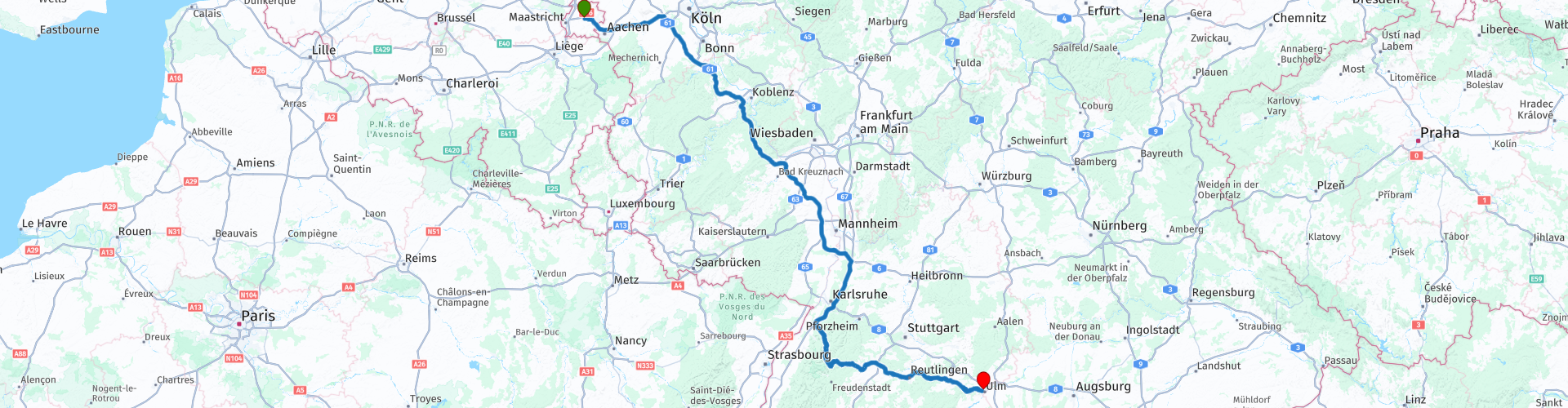
 The outward journey takes you from Climbing to Ulm. The first part of the route is on the highway to cover a greater distance. On the way, breaks are included every 2 hours to recover from the “sitting and driving”.
From Rastatt you leave the highway to continue on wonderfully sloping roads through the Black Forest to the end point in Ulm. During this part you will encounter a number of sights such as the Unimog museum, some castle ruins and the Blautopf. The sights provide a nice diversion from the long drive.
Eventually you will arrive at Hotel Lehrertal Garni in Ulm. At the end of the day, if you still feel like it, you can walk into the old town of Ulm on foot to soak up the atmosphere and possibly grab a bite to eat. A number of POIs are included in the route, which you can visit in the center.
 Share this route


Animation

Verdict


Duration
6h 55m

Mode of travel
Car or motorcycle

Distance
581.16 km

Countries


 RouteXpert Review
 This ride takes you from Ice cream shop Pleinzicht in Klimmen to Hotel Garni Lehrertal in Ulm. The route gets 3 stars: a large part of the route is on the highway, in order to bridge the distance to the South-East. Later in the afternoon you will finally drive into the back roads of the Black Forest, with some beautiful views and interesting places to stop.
As said, most of this route is one of “stay and drive on”. From the ice cream parlor in Klimmen you go almost immediately on the highway. The next 380km (about 4 hours driving without traffic jams and breaks) you will cross a great distance to finally start the fun part of the route at Rastatt. To be able to keep this part full, you can take a break every 2 hours at one of the break places along the highway. Along the way you will also drive over the Moseltalbrucke. Just before crossing the Moselle Valley, you can stop at a spot along the highway to enjoy the view and take some pictures (RP 4).
Once in the Black Forest you drive on wonderfully winding roads towards Ulm. The Black Forest is the largest forest area in Germany, and very touristy. You notice this immediately because you regularly meet other motorcyclists on the way. You will soon pass the Unimog museum (RP 9). Those interested can stop here and visit the museum. In 1946, the UNIversal MOTor Gerät ("universal motor machine") was first introduced to serve as an agricultural machine. In the centuries that followed, the company continued to grow and the Unimogs were also used by the army, the fire brigade, it became an extreme camper and even Unimogs participated in the Dakar. In the museum you can admire several special machines, learn more about the history of the brand. And perhaps the best part: you can test a Unimog on the off-road track behind the museum.
After this outing you can continue the route and enjoy some special castles along the route in peace. You will pass the Rotenfels castle (RP 10) in Bad Rotenfels. This castle was originally a Porcelain Factory in 1800. Soon the factory could no longer compete with cheaper porcelain from Asia. In addition, production costs rose: to burn the ovens in the factory, wood was cut in the area. After all the wood had been cut, wood had to be removed from further away, which increased transport costs. Eventually, the owner decided to close the factory and the building was converted into a country house. For years, a noble family lived in the house until it was finally turned into an art school.
Slowly it is time for a break. Depending on when you want to take a break yourself, you can stop sooner or later. The first marked break area is in the village of Forbach. Just across the river Murg you can stop at Restaurant Friedrichshof (RP 11). You can take a break here and take a break from the ride. If you can continue driving, you can consider stopping at Restaurant Neumühle (RP 14). This restaurant is located in the middle of the nature of the Black Forest, between the trees and on the banks of the Nagold river. Here you can enjoy a fantastic view on the terrace as well as motorcyclists touring by.
That same river plays a leading role in your route. Even before your break you have already passed the origin of the river and a little later the river leads you a lot to the city of the same name Nagold. As you enter the city, you will see an old ruin (RP 15) towering above the city. Hohennagold's medieval castle ruins stand on top of the Schlossberg and are unfortunately only accessible on foot. the first mention of a castle at this location dates from around 750; the current castle ruin dates from 1100. Several graves lived in the castle until around 1650 the castle was severely damaged during the Thirty Years' War. After WWII, the ruin was restored to its current state.
A little further on you will pass the ruins of Hohenurach Castle (RP 18) in Bad Urach, which overlooks the valley of the Erms river. Dating from 1025, this castle served to perpetuate the power of the city of Bad Urach in the Middle Ages, but also as a prison in later times.
Towards the end of the route you can take a break in Blaubeuren (RP 21). This special town is home to a special natural phenomenon: the Blautopf. This is the source of the river Blau and from a huge underground cave system a striking blue-colored water bubbles up into the spring basin, on which lies the Alte Hammerschmiede annex watermill. There is also a monastery here dating from 1085. The old city center is protected, so you can not enter it by motorbike (or car). Along the route you will find several parking spaces from where you can walk into the old town and visit the Blautopf, the watermill and the monastery. Of course there are several nice terraces where you can take a break before you start the last part of your route.
After a long day of driving, you will arrive at Hotel Garni Lehrertal in Ulm. The hotel is located outside the center, but you can easily walk to the old town from here and choose a restaurant for dinner. If you do not arrive late, it is definitely worthwhile to go into the city and visit cultural hotspots such as the Ulmer Münster, Fischerviertel, the town hall with accompanying library and the Ulmer Festung. The route contains the POIs of these places.


 Links
Links  Usage
Usage Want to download this route?
You can download the route for free without MyRoute-app account. To do so, open the route and click 'save as'. Want to edit this route?
No problem, start by opening the route. Follow the tutorial and create your personal MyRoute-app account. After registration, your trial starts automatically.  Disclaimer
Use of this GPS route is at your own expense and risk. The route has been carefully composed and checked by a MyRoute-app accredited RouteXpert for use on TomTom, Garmin and MyRoute-app Navigation.
Changes may nevertheless have occurred due to changed circumstances, road diversions or seasonal closures. We therefore recommend checking each route before use.
Preferably use the route track in your navigation system. More information about the use of MyRoute-app can be found on the website under 'Community' or 'Academy'.

Rheinland Pfalz
About this region
Rhineland-Palatinate (German: Rheinland-Pfalz, [ˈʁaɪ̯nlant ˈp͡falt͡s] (listen)) is a western state of Germany. It covers 19,846 km2 (7,663 sq mi) and has about 4.05 million residents. It is the ninth largest and sixth most populous of the sixteen states. Mainz is the capital and largest city. Other cities are Ludwigshafen am Rhein, Koblenz, Trier, Kaiserslautern and Worms. It is bordered by North Rhine-Westphalia, Saarland, Baden-Württemberg and Hesse and by the countries France, Luxembourg and Belgium.
Rhineland-Palatinate was established in 1946 after World War II, from parts of the former states of Prussia (part of its Rhineland province), Hesse and Bavaria (its former outlying Palatinate kreis or district), by the French military administration in Allied-occupied Germany. Rhineland-Palatinate became part of the Federal Republic of Germany in 1949 and shared the country's only border with the Saar Protectorate until the latter was returned to German control in 1957. Rhineland-Palatinate's natural and cultural heritage includes the extensive Palatinate winegrowing region, picturesque landscapes, and many castles and palaces.
Read more on Wikipedia
Rhineland-Palatinate was established in 1946 after World War II, from parts of the former states of Prussia (part of its Rhineland province), Hesse and Bavaria (its former outlying Palatinate kreis or district), by the French military administration in Allied-occupied Germany. Rhineland-Palatinate became part of the Federal Republic of Germany in 1949 and shared the country's only border with the Saar Protectorate until the latter was returned to German control in 1957. Rhineland-Palatinate's natural and cultural heritage includes the extensive Palatinate winegrowing region, picturesque landscapes, and many castles and palaces.
View region
 Statistics
  137
137Amount of RX reviews (Rheinland Pfalz)
 44684
44684Amount of visitors (Rheinland Pfalz)
 27336
27336Amount of downloads (Rheinland Pfalz)
 Route Collections in this region
 Top 5 Car and Motorcycle Routes in the Eifel
The Eifel is the eastern part of the medium plateau Eifel-Ardennes. It is located north of the Moselle and west of the Rhine. The largest part is in Germany, a small part is in Belgium, in the East Cantons. The German part of Eifel is located in the federal states of North Rhine-Westphalia and Rhineland-Palatinate. The highest point is the Hohe Acht with 747 meters.
Several chains can be distinguished in the Eifel:
The northernmost part is called the Nordeifel, which in Belgium connects to the High Fens;
To the east of this is the Ahrgebirge, this part is located north of the Ahr in the Ahrweiler district;
South of the Ahr is the Hohe Eifel (or Hocheifel), of which the Hohe Acht (747 m) is the highest point, and also the highest point in the entire Eifel region;
To the west, near the Belgian border, the hills are known as Schneifel, part of the wider Snow Eifel area with peaks reaching up to 698 metres;
South and east of the Hohe Eifel is the Volcano-Eifel, a volcanic area with many crater lakes (Maare).
The southern part of the Eifel is less high. The area is bisected by streams and rivers running southwards. These streams flow into the Moselle. The largest of these rivers is the Kyll; the hills around this river are known as the Kyllwald;
In the south, the Eifel ends in the Voreifel.
In the north of the Eifel there are some large reservoirs. The largest of these is the reservoir in the Roer that was created by the construction of the Roerdal dam.
The Nürburgring is also located in the Eifel, a well-known car circuit for Formula 1 races, among other things. Since 2004, part of the north of the Eifel has become the Eifel National Park. This National Park falls entirely within the German-Belgian nature park High Fens-Eifel. Another part of the Eifel falls within the South Eifel Nature Park.
Well-known throughout the Netherlands and Belgium by car and motorcyclists, so reason enough for the MyRoute app RouteXpert to compile a Top 5 of Car and Motorbike routes for you.
All routes in this collection have been checked and made equal for TomTom, Garmin and MyRoute-app Navigation by a MyRoute-app RouteXpert.
If you think, I have a very nice route that should certainly not be missing from this collection, send it to:
email: routeexpert@myrouteapp.com
Subject: New Route for the Top 5 collection Eifel composed by Hans van de Ven.
The route will then be reviewed and then added to the Top 5. To make the Top 5 also the Top 5, 1 route will have to disappear from the Top 5, you can indicate this when submitting the new route.
Have fun with this collection and while driving one of these routes. Enjoy all the beauty that the Eifel has to offer. Click on “View route” to read the review of the chosen route.
I would like to hear your findings about the route(s).
View Route Collection
Route collection hairpins in the Eifel
This collection is composed of the most beautiful and winding roads in the Eifel. Forget Bundesstraßen, forget the road along the Moselle, if you have driven these roads, you can really say that you have been to the Eifel.
No less than 6 routes and 1,800 kilometers are waiting for you!
No less than 6 routes and 1,800 kilometers are waiting for you!
View Route Collection