Through the High Eifel

This route was brought to you by:
RouteXpert Jan Koelstra - Senior Rx
Last edit: 03-08-2024
 Route Summary
 Arrival: Parkplatz Kino Daun
This is the second stage of a series of three routes through the high Eifel. This route runs from Kronenburg to Daun and is over 100 km long. It takes you over good, but winding and sometimes steep roads, through the forests, past fields with panoramic views, mountain streams and then castles, castles and especially mountain ruins. You will pass through beautiful, typical Eifel villages with half-timbered houses and nice squares that invite you for a cup of coffee or a drink.
Pay attention to the indication at route point 28. It is easy to make a wrong turn here.
Very nice route to drive through the Volcano Eifel via beautiful winding roads, interspersed with the occasional hairpin bend. This route is also easy to ride for novice motorcyclists. There are plenty of opportunities to stop along the way. Your eyes will hurt from the varied images on this route and it will give you a feeling of satisfaction. I also rate this route with 5 stars.
 Share this route


Animation

Verdict


Duration
5h 45m

Mode of travel
Car or motorcycle

Distance
110.76 km

Countries

 RouteXpert Review
 It takes you over good, but winding and sometimes steep roads through forests, fields with panoramic views, along mountain streams and then castles, castles and especially mountain ruins. You pass through beautiful, fresh villages with half-timbered houses and nice terraces that invite you for a cup of coffee.
This is the heart of the Eifel, also called the Volcanic Eifel, which, like the rest of the Eifel, is characterized by beautiful nature and beautiful views. Especially in the more “rugged” Volcanic Eifel you can enjoy very beautiful panoramic views.
If you haven't done it yet, Kronenburg is worth a stroll through. It is a medieval village located at an altitude of approximately 560 meters. It is just within the Nord Eifel Nature Park, in the Upper Kylltal. That is the valley through which the river Kyll flows. The town has approximately 460 inhabitants. But all year round there are quite a few tourists who come to this beautiful medieval town and the beautiful nature in the area.
After refuelling, you will pass the town of Stadskyll. Some remains of the old city walls in the town are worth seeing, because the town has suffered a lot from fires in the past. You turn right towards Kerschenbach and drive through typical Eifel villages.
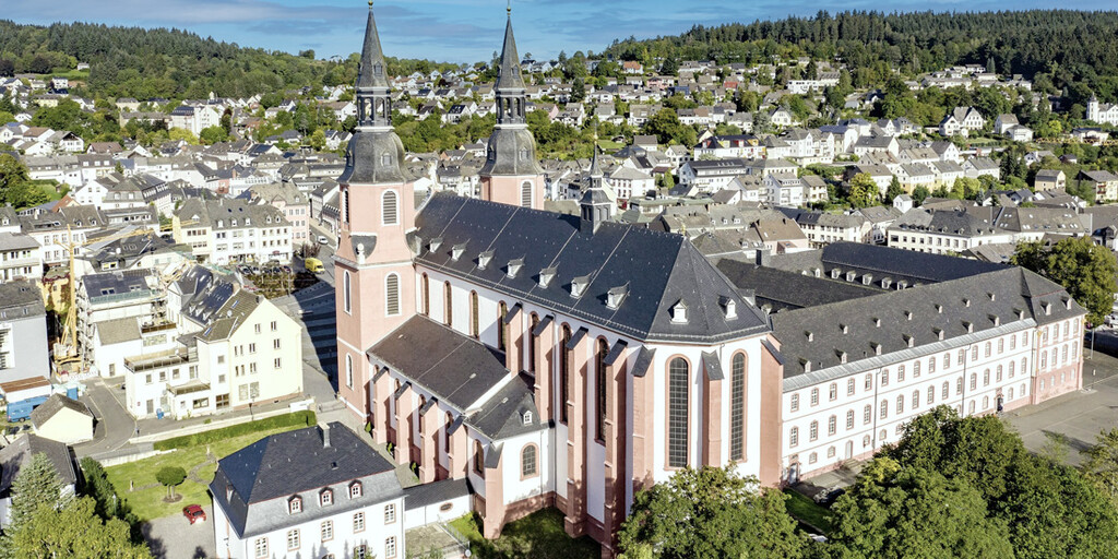
Continuing along you will reach the old town of Prüm, which boasts a jewel of Romanesque architecture: the St. Salvator Basilica, the former abbey church. This centuries-old basilica is known for its historical significance, impressive architecture and one of the most enchanting features of St. Salvator Basilica is its cloister. Here you can wander around in peace and enjoy the serene atmosphere. The basilica is centrally located in the historic center of Prüm and is easily accessible on foot or by car.
There is time for coffee here. More information see link Prüm
The Brunnen and Skulpturenpark Hubert Kruft is located in the Eifel town of Niederprüm (before Prüm). An ongoing exhibition of a number of artists who make their sculptures from bronze and copper, among other things. More information see link Niederprüm
From here south, crossing the highway, you arrive at the narrow rocky valley of the Nims, a stretch of valley that extends just past the beautifully situated Schönecken with its castle ruins, which is beautiful and varied. At the village of Seffern, which is picturesquely situated in a valley basin, you take the road up to Selfferweich where you then descend again via the rural Malberg and Kyllburg, picturesquely situated on a mountainside and around which the Kyll flows. Malberg and Kyllburg are known for their castles.
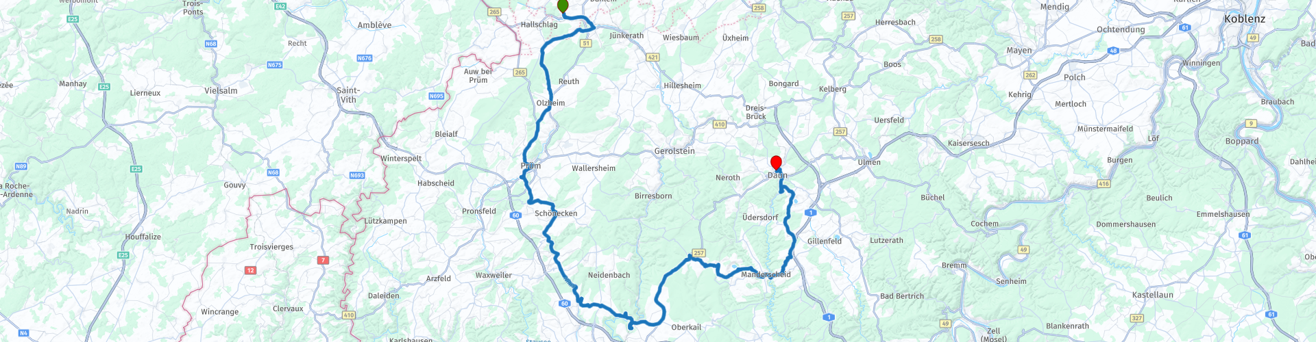
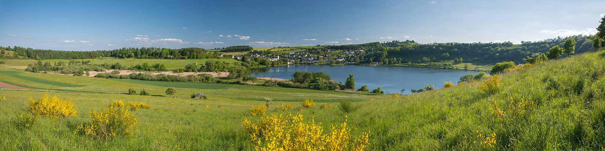
You are now driving through the central part of the Volcanic Eifel. Here the volcanoes once formed crater lakes (Maare). You will soon encounter them, such as the Meerfelder But just west of Manderscheid and just before Daun you will encounter a few more.
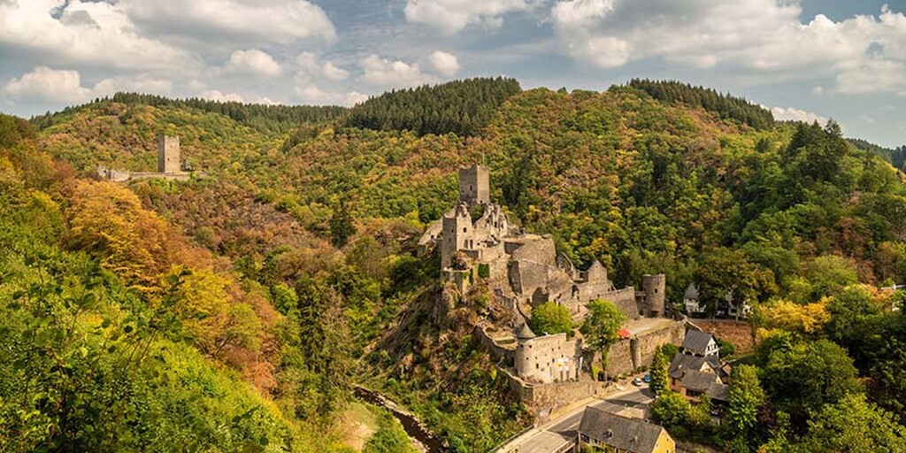
Manderscheid is a rustic town on the Lieser river. This town has as eye-catchers the castles of Oberburg and Niederburg. These are prominently present in this beautiful town in the Eifel. The names of the castles say everything about their location. the Oberburg above the Niederburg. They are separated by the Lieser river. In the past, the Lieser formed the border between the power bloc of the Archbishop of Trier and the Counts of Luxembourg.
Manderscheid is a good place for lunch.
As mentioned, when you approach the Daun end point, you will pass a few more volcanic lakes. They are located between the town of Daun and Schalkenmehren and can be admired from a beautiful viewing tower. This observation tower called Dronketurm, which can be reached on foot from the Weinfelder Maar, offers a magnificent view of the three Maars; the Schalkenmehrener Maar, the Weinfelder Maar and the Gemünder Maar. Not included in the route, but if you have extra time this is a good addition, count on an hour. see link Dronketurm.
There is an opportunity to have a drink at the Gemünder Maar.
The old town of Daun is located on the Lieser, a narrow river that eventually flows into the Moselle. There are several interesting sights in Daun. The Eifel Volcano Museum is well worth a visit. The city itself also invites you to take a stroll through it and view the various beautiful old buildings, such as the Saint Nicholas (Nicolas) church from the thirteenth century, the Kurfurstliches Amtshaus, now used as a beautiful romantic hotel. The Evangelical cemetery and grave monuments from the nineteenth century. The surroundings are also beautiful to explore. The Daun viaduct, an imposing high railway bridge from 1909 and the Daun Wildlife Park.
This is where this trip ends. There are plenty of hotels in this town.
 Links
Links  Usage
Usage Want to download this route?
You can download the route for free without MyRoute-app account. To do so, open the route and click 'save as'. Want to edit this route?
No problem, start by opening the route. Follow the tutorial and create your personal MyRoute-app account. After registration, your trial starts automatically.  Disclaimer
Use of this GPS route is at your own expense and risk. The route has been carefully composed and checked by a MyRoute-app accredited RouteXpert for use on TomTom, Garmin and MyRoute-app Navigation.
Changes may nevertheless have occurred due to changed circumstances, road diversions or seasonal closures. We therefore recommend checking each route before use.
Preferably use the route track in your navigation system. More information about the use of MyRoute-app can be found on the website under 'Community' or 'Academy'.

Rheinland Pfalz
About this region
Rhineland-Palatinate (German: Rheinland-Pfalz, [ˈʁaɪ̯nlant ˈp͡falt͡s] (listen)) is a western state of Germany. It covers 19,846 km2 (7,663 sq mi) and has about 4.05 million residents. It is the ninth largest and sixth most populous of the sixteen states. Mainz is the capital and largest city. Other cities are Ludwigshafen am Rhein, Koblenz, Trier, Kaiserslautern and Worms. It is bordered by North Rhine-Westphalia, Saarland, Baden-Württemberg and Hesse and by the countries France, Luxembourg and Belgium.
Rhineland-Palatinate was established in 1946 after World War II, from parts of the former states of Prussia (part of its Rhineland province), Hesse and Bavaria (its former outlying Palatinate kreis or district), by the French military administration in Allied-occupied Germany. Rhineland-Palatinate became part of the Federal Republic of Germany in 1949 and shared the country's only border with the Saar Protectorate until the latter was returned to German control in 1957. Rhineland-Palatinate's natural and cultural heritage includes the extensive Palatinate winegrowing region, picturesque landscapes, and many castles and palaces.
Read more on Wikipedia
Rhineland-Palatinate was established in 1946 after World War II, from parts of the former states of Prussia (part of its Rhineland province), Hesse and Bavaria (its former outlying Palatinate kreis or district), by the French military administration in Allied-occupied Germany. Rhineland-Palatinate became part of the Federal Republic of Germany in 1949 and shared the country's only border with the Saar Protectorate until the latter was returned to German control in 1957. Rhineland-Palatinate's natural and cultural heritage includes the extensive Palatinate winegrowing region, picturesque landscapes, and many castles and palaces.
View region
 Statistics
  143
143Amount of RX reviews (Rheinland Pfalz)
 57699
57699Amount of visitors (Rheinland Pfalz)
 31004
31004Amount of downloads (Rheinland Pfalz)
 Route Collections in this region
 Top 5 Car and Motorcycle Routes in the Eifel
The Eifel is the eastern part of the medium plateau Eifel-Ardennes. It is located north of the Moselle and west of the Rhine. The largest part is in Germany, a small part is in Belgium, in the East Cantons. The German part of Eifel is located in the federal states of North Rhine-Westphalia and Rhineland-Palatinate. The highest point is the Hohe Acht with 747 meters.
Several chains can be distinguished in the Eifel:
The northernmost part is called the Nordeifel, which in Belgium connects to the High Fens;
To the east of this is the Ahrgebirge, this part is located north of the Ahr in the Ahrweiler district;
South of the Ahr is the Hohe Eifel (or Hocheifel), of which the Hohe Acht (747 m) is the highest point, and also the highest point in the entire Eifel region;
To the west, near the Belgian border, the hills are known as Schneifel, part of the wider Snow Eifel area with peaks reaching up to 698 metres;
South and east of the Hohe Eifel is the Volcano-Eifel, a volcanic area with many crater lakes (Maare).
The southern part of the Eifel is less high. The area is bisected by streams and rivers running southwards. These streams flow into the Moselle. The largest of these rivers is the Kyll; the hills around this river are known as the Kyllwald;
In the south, the Eifel ends in the Voreifel.
In the north of the Eifel there are some large reservoirs. The largest of these is the reservoir in the Roer that was created by the construction of the Roerdal dam.
The Nürburgring is also located in the Eifel, a well-known car circuit for Formula 1 races, among other things. Since 2004, part of the north of the Eifel has become the Eifel National Park. This National Park falls entirely within the German-Belgian nature park High Fens-Eifel. Another part of the Eifel falls within the South Eifel Nature Park.
Well-known throughout the Netherlands and Belgium by car and motorcyclists, so reason enough for the MyRoute app RouteXpert to compile a Top 5 of Car and Motorbike routes for you.
All routes in this collection have been checked and made equal for TomTom, Garmin and MyRoute-app Navigation by a MyRoute-app RouteXpert.
If you think, I have a very nice route that should certainly not be missing from this collection, send it to:
email: routeexpert@myrouteapp.com
Subject: New Route for the Top 5 collection Eifel composed by Hans van de Ven.
The route will then be reviewed and then added to the Top 5. To make the Top 5 also the Top 5, 1 route will have to disappear from the Top 5, you can indicate this when submitting the new route.
Have fun with this collection and while driving one of these routes. Enjoy all the beauty that the Eifel has to offer. Click on “View route” to read the review of the chosen route.
I would like to hear your findings about the route(s).
View Route Collection
Route collection hairpins in the Eifel
This collection is composed of the most beautiful and winding roads in the Eifel. Forget Bundesstraßen, forget the road along the Moselle, if you have driven these roads, you can really say that you have been to the Eifel.
No less than 6 routes and 1,800 kilometers are waiting for you!
No less than 6 routes and 1,800 kilometers are waiting for you!
View Route Collection