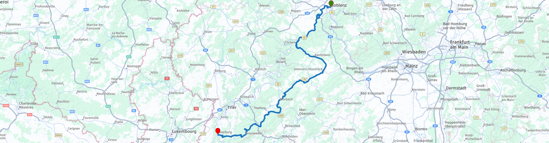
Hunsrueck highway from Koblenz

This route was brought to you by:
RouteXpert Jan Koelstra - Senior Rx
Last edit: 27-08-2024
 Route Summary
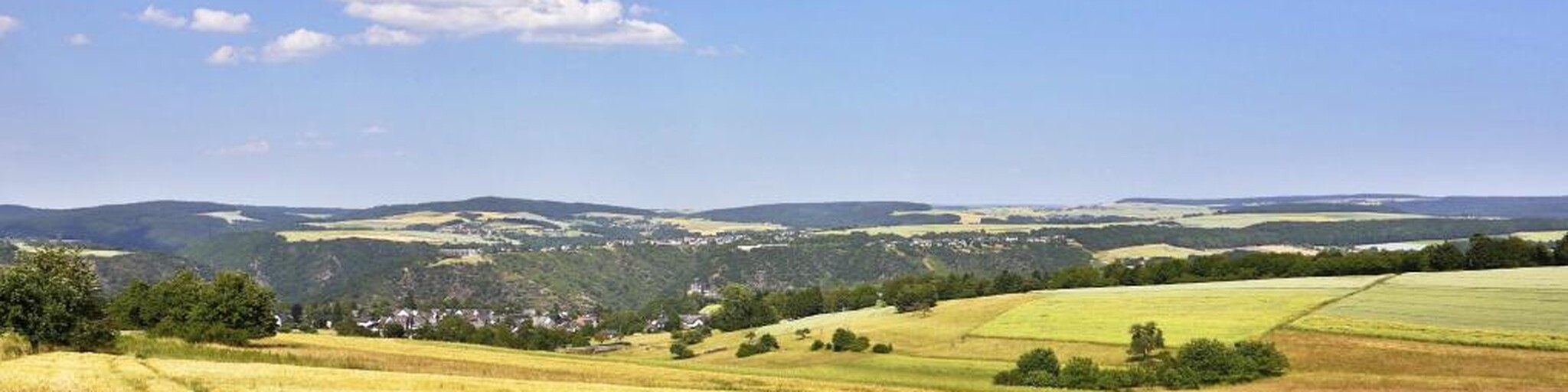
 It is certainly worth taking a short break every now and then and looking around you, because there is so much to discover along the paths and just off the beaten track. For example in protected forest areas such as the Hunsrück-Hochwald National Park or the Saar-Hunsrück and Soonwald-Nahe Nature Park.
But also attractions like the Geierlay suspension bridge await adventurers with excitement. Several tourist resorts are located on the Strasse such as Kastellaun with its castles, the winter sports resort Morbach and Hermeskeil with the impressive aircraft museum. Thalfang and Kirchberg are somewhat more modest. Holidaymakers admire the half-timbered houses and appreciate the cosiness that can be found in the towns of Simmern, Kirchberg and in the small villages.
A varied landscape that invites you to recharge and relax. The towns with their half-timbered houses and cosiness, the fantastic views and the pleasure of a pleasant road network provide a five-star rating
 Share this route


Animation

Verdict


Duration
5h 54m

Mode of travel
Car or motorcycle

Distance
199.84 km

Countries

 RouteXpert Review
 After the Celts and Romans, came the counts and bishops. From the medieval rulers, the ruins of old castles remain as stone remains that keep the memory of times long past alive. The local specialities and culinary delights also ensure that you will remember your special stay on the Hunsrück for a long time to come.
The approximately 140 km long Hunsrück-Hohenstrasse runs from northwest to southeast right through the Hunsrück, connecting the towns of Koblenz and Saarburg.
Because it leads over the undulating Hunsrück plateau. where heathland and forests follow each other in colorful alternation. this road is also suitable for the less hurried tourist for a round trip, possibly in combination with trips through the Eifel or routes along the Nahe and Moselle. At numerous points roads from the Moselle, Rhine, Nahe and Saar valleys join the main road.
Several tourist resorts are located along the Hunsrück-Höhenstrasse: the most important of these is the picturesque Kastellaun on the northeastern part of the road. The same applies to Simmern, the main town of the Hunsrück and Hermeskeil, the main town of the Hochwald on the southwestern part of this route. Other places to stay on or near the Hunsrück-Höhenstrasse such as Thalfang, Morbach and Kirchberg are, if possible, even more modest and quiet. Your route is a free interpretation of the Hunsrück-Höhenstrasse and deviates from it regularly.
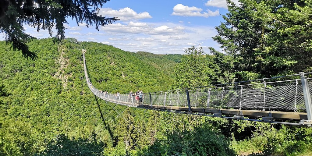
You leave Koblenz by following the Moselle with its wine villages and castles. At Treis-Karden the road goes up with successive bends. where you can enjoy beautiful retrospectives of the Moselle every now and then. Once at the top the landscape changes dramatically and you simply drive through forests and rolling grain fields. Soon a parking lot appears on the right where you can stable your workhorse to dare a crossing on foot over one of the longest suspension bridges in Europe (at a height of 100m and a length of 360m). At least if you are not afraid of heights. But if you dare you will be treated to an unforgettable experience. The Geierlay was built after the example of Nepalese suspension bridges and hangs between two bridgeheads. From the parking lots it is about one and a half to two kilometers walk to the Geierlay Hangbrücke. Only the first parking lot P4 is free, the following ones become increasingly expensive.
Via Morsdorf you soon arrive in the picturesque Kastellaun, where it is time for a cup of coffee on a terrace with a view of the castle ruins on top of a rock. Continuing on, you follow the road to the capital of the Hunsrück, Simmern. The town is a typical example of this region with its springs and half-timbered houses, city gates and watchtowers. In Kirchberg, which is a little further away, there are even more half-timbered houses to admire. The historic market square in Kirchberg is particularly beautiful.
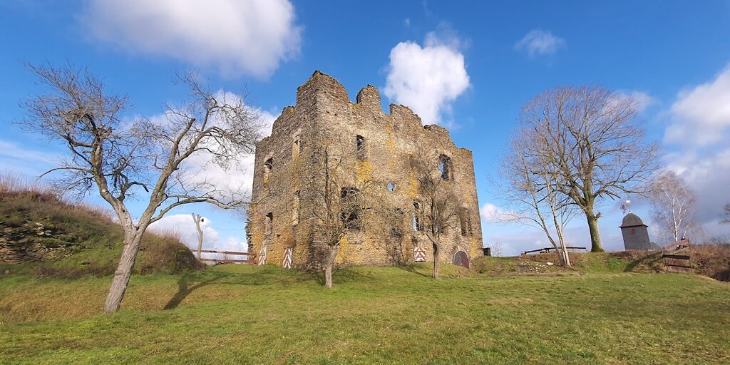
Continuing along the road, Burg Dill suddenly appears; definitely worth a photo. It is located in the middle of the village and is one of the oldest castles in the Hunsrück and consists of an upper and lower castle. Its beginnings date back to the first quarter of the 12th century.
Visitors to the Archeology Park Belginum can explore the site via a circular walk of approximately 1,000 metres. This route takes in a cemetery with burial mounds, the former Roman settlement, a military camp and a well. Each of these stations is accompanied by informative display boards, which provide detailed explanations and historical context.
A few kilometres further on, in the bend in the road, you will come across a moated castle. Between Morbach and Hinzerath lie the ruins of Baldenau Castle, the only moated castle in the Hunsrück. Founded around 1320, the impressive ruins are still beautifully situated in the Dhron valley.
The highest peak in the Hunsrück Hochwald National Park is the Erbeskopf. At 816 metres above sea level, this is of course just a small mountain, but you can still ski here in the winter. There are three slopes and two lifts, but of course you don't need them if you're there in August. Fortunately, they have also arranged summer entertainment on the slope of the Erbeskopf in the form of the Erbeskopf summer toboggan run. On the 1356 metre long track, you can reach a speed of 42 km/h.
Where you should stop is the next attraction. It is a private aviation museum located near Hermeskeil and has a collection of over 100 civil and military aircraft and helicopters. This extensive collection offers a deep insight into the history and development of aviation, making it a fascinating destination for aviation history enthusiasts. Spend a nice afternoon together among the aircraft and admire the family private collection of 40 beautiful aircraft and then eat something delicious together in the restaurant that is located in a real Concorde. Nice!
The Keller Stausee attracts many holidaymakers. Popular activities include canoeing, pedal boating, fishing or walking along the path that runs around the lake.
Then the road runs as familiarly through the forests and hills of Saarland. You gradually approach the end point in Saarburg. On the banks of the Saar lies the idyllic town, surrounded by steep slopes, extensive vineyards and wooded areas. Every year the Saarland attracts many hiking and cycling enthusiasts, thanks to the area full of old castles and extensive vineyards. The showpiece of the area is the Saarschleife: an almost round bend in the river near the town of Orscholz. Saarburg itself also offers many beautiful things: sit down on a terrace by the water or take the cable car to the top of the Warsberg for a beautiful view.
 Links
Links  Usage
Usage Want to download this route?
You can download the route for free without MyRoute-app account. To do so, open the route and click 'save as'. Want to edit this route?
No problem, start by opening the route. Follow the tutorial and create your personal MyRoute-app account. After registration, your trial starts automatically.  Disclaimer
Use of this GPS route is at your own expense and risk. The route has been carefully composed and checked by a MyRoute-app accredited RouteXpert for use on TomTom, Garmin and MyRoute-app Navigation.
Changes may nevertheless have occurred due to changed circumstances, road diversions or seasonal closures. We therefore recommend checking each route before use.
Preferably use the route track in your navigation system. More information about the use of MyRoute-app can be found on the website under 'Community' or 'Academy'.

Rheinland Pfalz
About this region
Rhineland-Palatinate (German: Rheinland-Pfalz, [ˈʁaɪ̯nlant ˈp͡falt͡s] (listen)) is a western state of Germany. It covers 19,846 km2 (7,663 sq mi) and has about 4.05 million residents. It is the ninth largest and sixth most populous of the sixteen states. Mainz is the capital and largest city. Other cities are Ludwigshafen am Rhein, Koblenz, Trier, Kaiserslautern and Worms. It is bordered by North Rhine-Westphalia, Saarland, Baden-Württemberg and Hesse and by the countries France, Luxembourg and Belgium.
Rhineland-Palatinate was established in 1946 after World War II, from parts of the former states of Prussia (part of its Rhineland province), Hesse and Bavaria (its former outlying Palatinate kreis or district), by the French military administration in Allied-occupied Germany. Rhineland-Palatinate became part of the Federal Republic of Germany in 1949 and shared the country's only border with the Saar Protectorate until the latter was returned to German control in 1957. Rhineland-Palatinate's natural and cultural heritage includes the extensive Palatinate winegrowing region, picturesque landscapes, and many castles and palaces.
Read more on Wikipedia
Rhineland-Palatinate was established in 1946 after World War II, from parts of the former states of Prussia (part of its Rhineland province), Hesse and Bavaria (its former outlying Palatinate kreis or district), by the French military administration in Allied-occupied Germany. Rhineland-Palatinate became part of the Federal Republic of Germany in 1949 and shared the country's only border with the Saar Protectorate until the latter was returned to German control in 1957. Rhineland-Palatinate's natural and cultural heritage includes the extensive Palatinate winegrowing region, picturesque landscapes, and many castles and palaces.
View region
 Statistics
  143
143Amount of RX reviews (Rheinland Pfalz)
 57699
57699Amount of visitors (Rheinland Pfalz)
 31004
31004Amount of downloads (Rheinland Pfalz)
 Route Collections in this region
 Top 5 Car and Motorcycle Routes in the Eifel
The Eifel is the eastern part of the medium plateau Eifel-Ardennes. It is located north of the Moselle and west of the Rhine. The largest part is in Germany, a small part is in Belgium, in the East Cantons. The German part of Eifel is located in the federal states of North Rhine-Westphalia and Rhineland-Palatinate. The highest point is the Hohe Acht with 747 meters.
Several chains can be distinguished in the Eifel:
The northernmost part is called the Nordeifel, which in Belgium connects to the High Fens;
To the east of this is the Ahrgebirge, this part is located north of the Ahr in the Ahrweiler district;
South of the Ahr is the Hohe Eifel (or Hocheifel), of which the Hohe Acht (747 m) is the highest point, and also the highest point in the entire Eifel region;
To the west, near the Belgian border, the hills are known as Schneifel, part of the wider Snow Eifel area with peaks reaching up to 698 metres;
South and east of the Hohe Eifel is the Volcano-Eifel, a volcanic area with many crater lakes (Maare).
The southern part of the Eifel is less high. The area is bisected by streams and rivers running southwards. These streams flow into the Moselle. The largest of these rivers is the Kyll; the hills around this river are known as the Kyllwald;
In the south, the Eifel ends in the Voreifel.
In the north of the Eifel there are some large reservoirs. The largest of these is the reservoir in the Roer that was created by the construction of the Roerdal dam.
The Nürburgring is also located in the Eifel, a well-known car circuit for Formula 1 races, among other things. Since 2004, part of the north of the Eifel has become the Eifel National Park. This National Park falls entirely within the German-Belgian nature park High Fens-Eifel. Another part of the Eifel falls within the South Eifel Nature Park.
Well-known throughout the Netherlands and Belgium by car and motorcyclists, so reason enough for the MyRoute app RouteXpert to compile a Top 5 of Car and Motorbike routes for you.
All routes in this collection have been checked and made equal for TomTom, Garmin and MyRoute-app Navigation by a MyRoute-app RouteXpert.
If you think, I have a very nice route that should certainly not be missing from this collection, send it to:
email: routeexpert@myrouteapp.com
Subject: New Route for the Top 5 collection Eifel composed by Hans van de Ven.
The route will then be reviewed and then added to the Top 5. To make the Top 5 also the Top 5, 1 route will have to disappear from the Top 5, you can indicate this when submitting the new route.
Have fun with this collection and while driving one of these routes. Enjoy all the beauty that the Eifel has to offer. Click on “View route” to read the review of the chosen route.
I would like to hear your findings about the route(s).
View Route Collection
Route collection hairpins in the Eifel
This collection is composed of the most beautiful and winding roads in the Eifel. Forget Bundesstraßen, forget the road along the Moselle, if you have driven these roads, you can really say that you have been to the Eifel.
No less than 6 routes and 1,800 kilometers are waiting for you!
No less than 6 routes and 1,800 kilometers are waiting for you!
View Route Collection