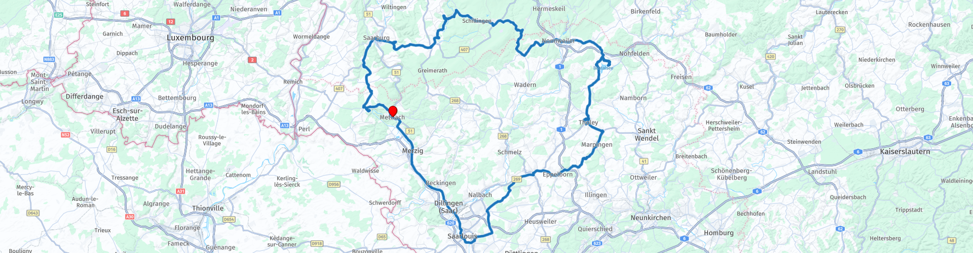
Roundtrip Saarland from Mettlach

This route was brought to you by:
RouteXpert Jan Koelstra - Senior Rx
Last edit: 18-08-2024
 Route Summary
 The region is named after the river Saar that flows through the state, while the Moselle forms the border with Luxembourg. Bordering Luxembourg and France, it is a wonderful holiday destination not too far away. The Saarland has a glorious history, during which it changed nationality several times. The coal and steel industry played an important role in this.
Today, the region is characterized by vast nature and many hidden characteristic villages. The Saarland in the west of Germany is known for its natural pearls: the Saarschleife is one of them; also the wild and romantic nature park Saar-Hunsrück with its lakes, villages and hills.
This route mainly goes through the western part of Saarland, where nature has the upper hand. In the south, the route takes in the fortified town of Saarlouis with its famous lookout tower, the Saar Polygon, built on a wooded coal mountain. In the east, it goes past Tholey, a centuries-old village with its 13th century Benedictine monastery, St. Mauritius, the lookout tower on the Schaumberg (with a view of the Hunsrück and the Nahe) and reservoirs (Eulensee and Bostalsee). In the north of the route, you will find the Hunsrück Hochwald wildlife park. At Bierfeld, the train disappears, but the cycle path appears (but also the new motorway) and west of this tour you will find the Saarschleife and castles along the Saar. Finally, in Mettlach, a visit to Viileroy and Boch is included.
The versatility of this route, the changing landscapes, the well-maintained and winding roads mean that this route gets five stars.
details
Due to map differences there are route deviations. Please note the directions at the route points indicated with the warning sign at the Bostalsee.
 Share this route


Animation

Verdict


Duration
9h 39m

Mode of travel
Car or motorcycle

Distance
174.00 km

Countries

 RouteXpert Review
 Discover this region with a rich (industrial) history, with beautiful and old towns and with ever-changing landscapes (from vineyards on the Moselle to rolling fields and meadows, from lakes to protected nature reserves with forests, rock formations and winding hiking trails). But in your case, you take your trusty workhorse. Historic towns, mills, farms and impressive landscapes pass you by on the way. Nature lovers go to the Hunsrück-Hochwald National Park.
Mettlach itself is also known as a porcelain town. The Villeroy & Boch company has been producing world-famous porcelain here since 1809. The tableware is the best-known, but sanitary ware and interior decoration are also part of the range. The former Benedictine abbey is not only home to the head office, but also to the Keravision documentation centre – with interesting facts about the production – and a pottery museum. The highlight of this museum is the tableware that Villeroy & Boch designed for Pope Benedict XVI (2005-2013). You can of course start your tour with a visit, but also afterwards, because the tour ends here.
Merzig is an attractive town, has been known for a long time. It is not without reason that it dates back to the time of the Romans. Merzig has therefore experienced many periods and that is reflected in the different architectural styles.
Looking for a unique experience? Visit the Wolf Park or go hiking in the Hochwald. The Losheim reservoir is also a must-see stop if you want to go paddling.
Saarlouis was founded by the French Sun King Louis XIV as a fortified city. The bastion, the casemates and the large market are worth seeing. Outside the city is the Saar Polygon, a reminder of the former coal mines. A special feature in this area is the Saar Polygon, dating from 2016, a polygonal and openwork steel structure that was erected as a monument in memory of the Saarland coal mining era. The Saar Polygon stands on top of a 150-metre-high waste mountain of the Bergwerk Saar coal mine. Climb the series of stone steps to the top of the 30-metre-high structure and enjoy the panoramic view of the Saar valley, hanging over the railing or relaxing on one of the benches on the viewing platform. The walk is easy to do, but still take a good half hour (3.5 km).
At the foot of the Schaumberg lies the health resort of Tholey. This village is best known for its 13th century Benedictine monastery, St. Mauritius. This monastery complex is known as the oldest in Germany. From the Schaumberg beautiful views over the Hunsrück.
In the small rivers Bos and Dämelbach a 500 meter long dam was built in 1979, which had a touristic purpose only: to create a recreational lake to promote tourism in the north of Saarland. This is how the Bostalsee came into being: a great place for water sports such as swimming, canoeing, sailing and windsurfing and around the lake there are several campsites, holiday homes and the Bostalsee recreation park where there is also a beach on the lake. Included in the route is the interesting inverted house, which you can visit.
The northern part of the route mainly goes along the Hunsrück nature reserve. Here you will find reservoirs, forests.
In Bierfeld the disused railway line is transformed into a cycle path. You can try the old railway (cycle) tunnel of several km.
Saarburg has a beautiful waterfall and a nice center. Although not officially located in Saarland, this town should not be missed during your visit to the region. The famous town is located on the river Saar and is known for the waterfall that plunges 20 meters down in the middle of the town. On both sides are colorful houses, sometimes with half-timbered facades. The upper course is lined with restaurants with terraces on the water and several ice cream parlors. Take a walk around the town, visit the castle above the town and take a walk through the adjacent vineyards.
The most famous sight of Saarland is undoubtedly the Saarschleife, which you can best view from the lookout tower. There is a spiraling tower Cloef, from where you have a good view over the river bend (see this header).
Don't forget to stop by the Villeroy & Boch Adventure Centre to round off this superb tour.


 Links
Links  Usage
Usage Want to download this route?
You can download the route for free without MyRoute-app account. To do so, open the route and click 'save as'. Want to edit this route?
No problem, start by opening the route. Follow the tutorial and create your personal MyRoute-app account. After registration, your trial starts automatically.  Disclaimer
Use of this GPS route is at your own expense and risk. The route has been carefully composed and checked by a MyRoute-app accredited RouteXpert for use on TomTom, Garmin and MyRoute-app Navigation.
Changes may nevertheless have occurred due to changed circumstances, road diversions or seasonal closures. We therefore recommend checking each route before use.
Preferably use the route track in your navigation system. More information about the use of MyRoute-app can be found on the website under 'Community' or 'Academy'.

Rheinland Pfalz
About this region
Rhineland-Palatinate (German: Rheinland-Pfalz, [ˈʁaɪ̯nlant ˈp͡falt͡s] (listen)) is a western state of Germany. It covers 19,846 km2 (7,663 sq mi) and has about 4.05 million residents. It is the ninth largest and sixth most populous of the sixteen states. Mainz is the capital and largest city. Other cities are Ludwigshafen am Rhein, Koblenz, Trier, Kaiserslautern and Worms. It is bordered by North Rhine-Westphalia, Saarland, Baden-Württemberg and Hesse and by the countries France, Luxembourg and Belgium.
Rhineland-Palatinate was established in 1946 after World War II, from parts of the former states of Prussia (part of its Rhineland province), Hesse and Bavaria (its former outlying Palatinate kreis or district), by the French military administration in Allied-occupied Germany. Rhineland-Palatinate became part of the Federal Republic of Germany in 1949 and shared the country's only border with the Saar Protectorate until the latter was returned to German control in 1957. Rhineland-Palatinate's natural and cultural heritage includes the extensive Palatinate winegrowing region, picturesque landscapes, and many castles and palaces.
Read more on Wikipedia
Rhineland-Palatinate was established in 1946 after World War II, from parts of the former states of Prussia (part of its Rhineland province), Hesse and Bavaria (its former outlying Palatinate kreis or district), by the French military administration in Allied-occupied Germany. Rhineland-Palatinate became part of the Federal Republic of Germany in 1949 and shared the country's only border with the Saar Protectorate until the latter was returned to German control in 1957. Rhineland-Palatinate's natural and cultural heritage includes the extensive Palatinate winegrowing region, picturesque landscapes, and many castles and palaces.
View region
 Statistics
  143
143Amount of RX reviews (Rheinland Pfalz)
 57702
57702Amount of visitors (Rheinland Pfalz)
 31004
31004Amount of downloads (Rheinland Pfalz)
 Route Collections in this region
 Top 5 Car and Motorcycle Routes in the Eifel
The Eifel is the eastern part of the medium plateau Eifel-Ardennes. It is located north of the Moselle and west of the Rhine. The largest part is in Germany, a small part is in Belgium, in the East Cantons. The German part of Eifel is located in the federal states of North Rhine-Westphalia and Rhineland-Palatinate. The highest point is the Hohe Acht with 747 meters.
Several chains can be distinguished in the Eifel:
The northernmost part is called the Nordeifel, which in Belgium connects to the High Fens;
To the east of this is the Ahrgebirge, this part is located north of the Ahr in the Ahrweiler district;
South of the Ahr is the Hohe Eifel (or Hocheifel), of which the Hohe Acht (747 m) is the highest point, and also the highest point in the entire Eifel region;
To the west, near the Belgian border, the hills are known as Schneifel, part of the wider Snow Eifel area with peaks reaching up to 698 metres;
South and east of the Hohe Eifel is the Volcano-Eifel, a volcanic area with many crater lakes (Maare).
The southern part of the Eifel is less high. The area is bisected by streams and rivers running southwards. These streams flow into the Moselle. The largest of these rivers is the Kyll; the hills around this river are known as the Kyllwald;
In the south, the Eifel ends in the Voreifel.
In the north of the Eifel there are some large reservoirs. The largest of these is the reservoir in the Roer that was created by the construction of the Roerdal dam.
The Nürburgring is also located in the Eifel, a well-known car circuit for Formula 1 races, among other things. Since 2004, part of the north of the Eifel has become the Eifel National Park. This National Park falls entirely within the German-Belgian nature park High Fens-Eifel. Another part of the Eifel falls within the South Eifel Nature Park.
Well-known throughout the Netherlands and Belgium by car and motorcyclists, so reason enough for the MyRoute app RouteXpert to compile a Top 5 of Car and Motorbike routes for you.
All routes in this collection have been checked and made equal for TomTom, Garmin and MyRoute-app Navigation by a MyRoute-app RouteXpert.
If you think, I have a very nice route that should certainly not be missing from this collection, send it to:
email: routeexpert@myrouteapp.com
Subject: New Route for the Top 5 collection Eifel composed by Hans van de Ven.
The route will then be reviewed and then added to the Top 5. To make the Top 5 also the Top 5, 1 route will have to disappear from the Top 5, you can indicate this when submitting the new route.
Have fun with this collection and while driving one of these routes. Enjoy all the beauty that the Eifel has to offer. Click on “View route” to read the review of the chosen route.
I would like to hear your findings about the route(s).
View Route Collection
Route collection hairpins in the Eifel
This collection is composed of the most beautiful and winding roads in the Eifel. Forget Bundesstraßen, forget the road along the Moselle, if you have driven these roads, you can really say that you have been to the Eifel.
No less than 6 routes and 1,800 kilometers are waiting for you!
No less than 6 routes and 1,800 kilometers are waiting for you!
View Route Collection