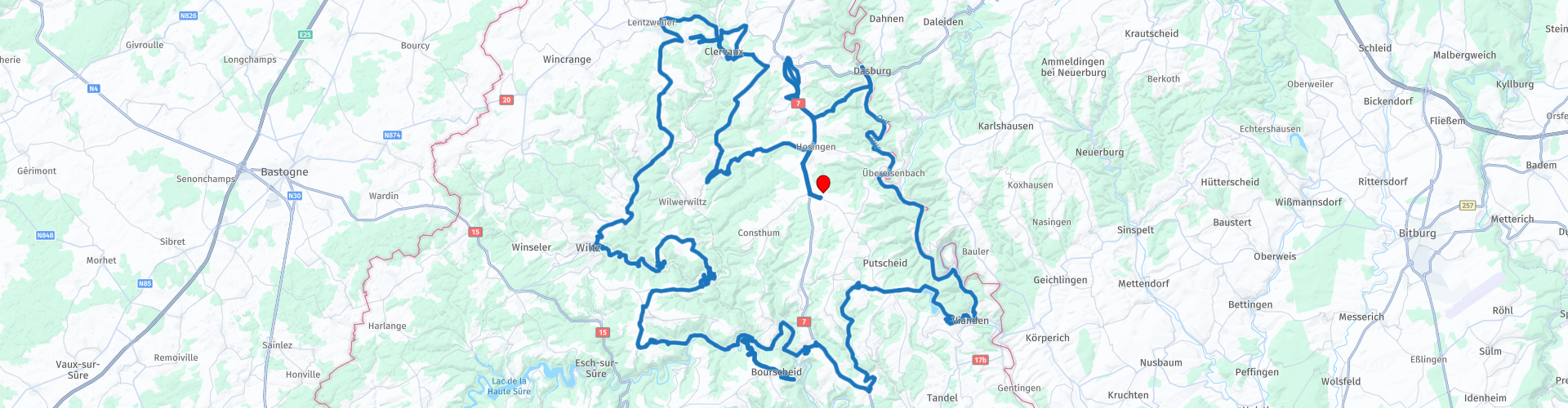
Hosingen Stolzemburg Vianden Bourscheid Wiltz Clervaux

This route was brought to you by:
RouteXpert Marinus van Deudekom (RXpert)
Last edit: 21-09-2024
 Route Summary
 If you’re looking for the perfect balance of adventure, history and nature, then this motorcycle route through Luxembourg is just what you need. Think rolling hills, hairpin bends that will get your heart racing and some of the most beautiful castles Europe has to offer. This is a route for the true motorcycle enthusiast, one that will not only give you the perfect riding experience, but will also take you past countless cultural and historical hotspots. So put on your leather jacket, start your engine and let’s start an unforgettable ride!
This route is one of the day trips of a motorcycle holiday in Luxembourg
Valuation:
Because of the great roads and bends for motorcyclists in this route I rate it with 5 stars.
Starting point and end point: Hösingen, Parc La Sapiniëre
 Share this route


Animation

Verdict


Duration
7h 28m

Mode of travel
Car or motorcycle

Distance
138.51 km

Countries


 RouteXpert Review
 You start your adventure in Hösingen, a village that gives you time to get into the mood for the ride. From here you can feel the freedom of the open Luxembourgish landscape. The village is surrounded by green hills and is the perfect place to warm up your engine before you start the real work.
Not much later you will drive along the border with Germany and you will see Dasburg on the other side of the river Our. There you will find the impressive Dasburg Castle, a medieval castle that stands proudly on a hilltop. The viewpoint on the route is a perfect first stop to stretch your legs and enjoy the view over the Our valley. You can even see the castle from that parking lot. The roads here are a foretaste of the bends you will encounter later on the route.
Then you come to the charming village of Stolzemburg, a small picturesque village steeped in history. Here you can visit the Saint Odon church, a peaceful spot perfect for a short break. But the best part? The hairpin bends just outside the village that will really test your driving skills!
The heart of the route Vianden is one of the highlights of the route and an absolute must-see. This historic town is situated on the Our River and is dominated by the impressive Château de Vianden. Before visiting the castle, you can stop at the viewpoints along the way for panoramic views of both the castle and the dam that spans the river. The Maison Victor Hugo, where the famous French writer stayed for a while, is also well worth a visit.
The next stop is Bourscheid, where you will once again be greeted by a breathtaking castle. Château de Bourscheid is perched on a high rock and offers stunning views of the surrounding area. The roads around this town are a delight to drive, with long, sweeping bends that let your bike glide gently through the valley.
Then the town of Wiltz appears, known for its rich history and the impressive Monument de la Grève, which commemorates the workers’ strike during World War II. If you are into culture and history, this is a great place to stop for a moment. Wiltz itself is set in fantastic surroundings and is a nice place to stop for lunch or a coffee before hitting the road again.
After Wiltz you will drive through Kautenbach, a small but picturesque village, and prepare for the last parts of the route. Clervaux is the last big city on your route and it is definitely worth spending some time here. Visit the impressive Abbaye Saint Maurice et Saint Maur, a beautiful monastery that exudes serene tranquility. The roads here are a bit wider and give you a wonderful feeling of freedom as you drive through the beautiful nature.
When you reach Siebenaler, you are almost at the end of the ride. This village is a nice place to enjoy the peace and quiet before you return to Hösingen. The roads here offer a few last sharp turns before you drive back to the finish.
Who is this route for?
This route is perfect for bikers looking for a mix of adventure, culture and nature. The hairpin bends around Vianden and Stolzemburg provide the necessary adrenaline, while the many cultural stops give you a glimpse into the rich history of Luxembourg. The roads are generally in excellent condition, so whether you are an experienced biker or just starting out, you will enjoy every kilometre.
Tips for on the road
Take your time to visit the castles and monuments along the route. Vianden and Bourscheid in particular deserve an extended stop.
Spring and summer are the ideal seasons for this route. Nature is at its most beautiful and the roads are dry, which makes the bends even more fun.
A ride to remember This motorcycle route through Luxembourg offers everything you could possibly want in a great ride. From challenging bends to breathtaking views, and from historic castles to quiet villages, this is a route that will enrich you both mentally and physically.
The route includes a number of places for a drink and a bite to eat for yourself and your motorbike, are you obliged to stop here? No, of course you can also determine your own stops.
You end the route at the reception and enjoy a snack and a drink while you reflect on today's route.


 Links
Links  Usage
Usage Want to download this route?
You can download the route for free without MyRoute-app account. To do so, open the route and click 'save as'. Want to edit this route?
No problem, start by opening the route. Follow the tutorial and create your personal MyRoute-app account. After registration, your trial starts automatically.  Disclaimer
Use of this GPS route is at your own expense and risk. The route has been carefully composed and checked by a MyRoute-app accredited RouteXpert for use on TomTom, Garmin and MyRoute-app Navigation.
Changes may nevertheless have occurred due to changed circumstances, road diversions or seasonal closures. We therefore recommend checking each route before use.
Preferably use the route track in your navigation system. More information about the use of MyRoute-app can be found on the website under 'Community' or 'Academy'.

Rheinland Pfalz
About this region
Rhineland-Palatinate (German: Rheinland-Pfalz, [ˈʁaɪ̯nlant ˈp͡falt͡s] (listen)) is a western state of Germany. It covers 19,846 km2 (7,663 sq mi) and has about 4.05 million residents. It is the ninth largest and sixth most populous of the sixteen states. Mainz is the capital and largest city. Other cities are Ludwigshafen am Rhein, Koblenz, Trier, Kaiserslautern and Worms. It is bordered by North Rhine-Westphalia, Saarland, Baden-Württemberg and Hesse and by the countries France, Luxembourg and Belgium.
Rhineland-Palatinate was established in 1946 after World War II, from parts of the former states of Prussia (part of its Rhineland province), Hesse and Bavaria (its former outlying Palatinate kreis or district), by the French military administration in Allied-occupied Germany. Rhineland-Palatinate became part of the Federal Republic of Germany in 1949 and shared the country's only border with the Saar Protectorate until the latter was returned to German control in 1957. Rhineland-Palatinate's natural and cultural heritage includes the extensive Palatinate winegrowing region, picturesque landscapes, and many castles and palaces.
Read more on Wikipedia
Rhineland-Palatinate was established in 1946 after World War II, from parts of the former states of Prussia (part of its Rhineland province), Hesse and Bavaria (its former outlying Palatinate kreis or district), by the French military administration in Allied-occupied Germany. Rhineland-Palatinate became part of the Federal Republic of Germany in 1949 and shared the country's only border with the Saar Protectorate until the latter was returned to German control in 1957. Rhineland-Palatinate's natural and cultural heritage includes the extensive Palatinate winegrowing region, picturesque landscapes, and many castles and palaces.
View region
 Statistics
  143
143Amount of RX reviews (Rheinland Pfalz)
 57699
57699Amount of visitors (Rheinland Pfalz)
 31004
31004Amount of downloads (Rheinland Pfalz)
 Route Collections in this region
 Top 5 Car and Motorcycle Routes in the Eifel
The Eifel is the eastern part of the medium plateau Eifel-Ardennes. It is located north of the Moselle and west of the Rhine. The largest part is in Germany, a small part is in Belgium, in the East Cantons. The German part of Eifel is located in the federal states of North Rhine-Westphalia and Rhineland-Palatinate. The highest point is the Hohe Acht with 747 meters.
Several chains can be distinguished in the Eifel:
The northernmost part is called the Nordeifel, which in Belgium connects to the High Fens;
To the east of this is the Ahrgebirge, this part is located north of the Ahr in the Ahrweiler district;
South of the Ahr is the Hohe Eifel (or Hocheifel), of which the Hohe Acht (747 m) is the highest point, and also the highest point in the entire Eifel region;
To the west, near the Belgian border, the hills are known as Schneifel, part of the wider Snow Eifel area with peaks reaching up to 698 metres;
South and east of the Hohe Eifel is the Volcano-Eifel, a volcanic area with many crater lakes (Maare).
The southern part of the Eifel is less high. The area is bisected by streams and rivers running southwards. These streams flow into the Moselle. The largest of these rivers is the Kyll; the hills around this river are known as the Kyllwald;
In the south, the Eifel ends in the Voreifel.
In the north of the Eifel there are some large reservoirs. The largest of these is the reservoir in the Roer that was created by the construction of the Roerdal dam.
The Nürburgring is also located in the Eifel, a well-known car circuit for Formula 1 races, among other things. Since 2004, part of the north of the Eifel has become the Eifel National Park. This National Park falls entirely within the German-Belgian nature park High Fens-Eifel. Another part of the Eifel falls within the South Eifel Nature Park.
Well-known throughout the Netherlands and Belgium by car and motorcyclists, so reason enough for the MyRoute app RouteXpert to compile a Top 5 of Car and Motorbike routes for you.
All routes in this collection have been checked and made equal for TomTom, Garmin and MyRoute-app Navigation by a MyRoute-app RouteXpert.
If you think, I have a very nice route that should certainly not be missing from this collection, send it to:
email: routeexpert@myrouteapp.com
Subject: New Route for the Top 5 collection Eifel composed by Hans van de Ven.
The route will then be reviewed and then added to the Top 5. To make the Top 5 also the Top 5, 1 route will have to disappear from the Top 5, you can indicate this when submitting the new route.
Have fun with this collection and while driving one of these routes. Enjoy all the beauty that the Eifel has to offer. Click on “View route” to read the review of the chosen route.
I would like to hear your findings about the route(s).
View Route Collection
Route collection hairpins in the Eifel
This collection is composed of the most beautiful and winding roads in the Eifel. Forget Bundesstraßen, forget the road along the Moselle, if you have driven these roads, you can really say that you have been to the Eifel.
No less than 6 routes and 1,800 kilometers are waiting for you!
No less than 6 routes and 1,800 kilometers are waiting for you!
View Route Collection