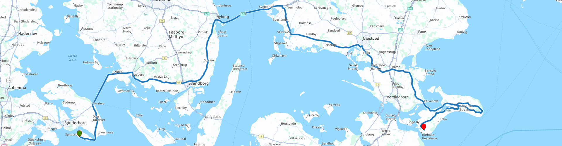
Day 3 Sonderby Nyborg Askeby

This route was brought to you by:
RouteXpert René Plücken (MRA Master)
Last edit: 08-03-2025
 Route Summary
 The roads in Denmark are very good, but the speed limits are very low, so take your time and plan ahead.
The countryside is beautiful and the panoramas along the coast are wonderful.
Motorcyclists are welcome at the campsites, of which there are plenty.
On this part of the journey you cross by ferry from Fynshav to Boyden, which is a nice break from the drive.
As sights we will visit Mont Klifs at the end of the day, and you can plan a visit to the town of Nyborg, which is highly recommended.
This route has a 4 star rating.
 Share this route


Animation

Verdict


Duration
8h 56m

Mode of travel
Car or motorcycle

Distance
297.33 km

Countries

 RouteXpert Review
 Today we drive on very good and beautiful roads in Denmark through a beautiful landscape with beautiful panoramas
Denmark has no winding mountain roads, but beautiful roads through a rolling landscape along the coasts of fjords and straits, so it is also very suitable for drivers with less experience.
The views along the coast are fantastic. There are several bridges and ferries to cross to the islands. Please note that there are tolls and some ferries require you to book a ticket in advance.
We drive from Sønderby via Nyborg to Askeby, crossing with the ferry from Fynshav to Boyden, tickets can be ordered online and cost €20.10 for motorcycle with rider. The crossing takes about 1 hour and is a wonderful relaxation, on board you can enjoy the beautiful view of "The Little Belt", a strait in Denmark, located between the Jutland peninsula and the island of Funen. The strait is about 50 kilometers long and 800 meters to 25 kilometers wide, with a maximum depth of 75 meters. Due to its depth, the strait drains 10% of the water from the Baltic Sea to the Kattegat.
From Boyden we drive on provincial roads to the town of Nyborg, where you can plan a stop. Nyborg is located on the eastern tip of the Danish island of Funen, which is connected to the neighboring island of Zealand via the Storebaelt or Great Belt Bridge. In addition to a bit of history and culture, you can also fully enjoy the fresh sea air and the peace. Stroll through the center with colorful houses, historical buildings and Nyborg Castle.
From Nyborg we drive over the Storebaelt or Great Belt Bridge over “The Great Belt”, this is a strait between the Danish islands of Zealand and Funen. Since 1997 the islands are connected by the Great Belt Bridge. The Great Belt is the largest of the three straits that connect the Kattegat with the Baltic Sea. The Great Belt is 60 km long and 16-32 km wide. The toll for the bridge is 120 DKK (€16.10) for a motorcycle with rider.
Before we drive to our campsite in Askeby we make another stop at the Møns Klint, the white cliffs of the Danish island of Møn. After a walk of about 20 minutes through the forests, they end at the chalk cliffs in the Baltic Sea. These chalk cliffs form Møns Klint. The rocks reach a height of 143 meters at their highest point. The pebble beach is accessible via a number of steep stairs, each with a few hundred steps. Entering the beach is not entirely without risk, because large pieces of chalk rock break off and disappear into the sea. You have to walk for about 20 minutes, but the view is definitely worth it.
After a drive of about 50 minutes from Møns Klint you arrive at the Møn Camping on the coast in Askeby, where you can spend the night in a tent. There is no restaurant on the campsite but there is a kitchen that you can use, so make sure you buy groceries or eat in a restaurant nearby.
If you want a bit more luxury and want to stay in a room or cabin and use a restaurant, then it is best to stay at Camp Møns Klint, near the chalk cliffs.


 Links
Links  Usage
Usage Want to download this route?
You can download the route for free without MyRoute-app account. To do so, open the route and click 'save as'. Want to edit this route?
No problem, start by opening the route. Follow the tutorial and create your personal MyRoute-app account. After registration, your trial starts automatically.  Disclaimer
Use of this GPS route is at your own expense and risk. The route has been carefully composed and checked by a MyRoute-app accredited RouteXpert for use on TomTom, Garmin and MyRoute-app Navigation.
Changes may nevertheless have occurred due to changed circumstances, road diversions or seasonal closures. We therefore recommend checking each route before use.
Preferably use the route track in your navigation system. More information about the use of MyRoute-app can be found on the website under 'Community' or 'Academy'.
Seeland
About this region
Seeland may refer to:
Read more on Wikipedia
View region
 Statistics
  3
3Amount of RX reviews (Seeland)
 11872
11872Amount of visitors (Seeland)
 260
260Amount of downloads (Seeland)
 Route Collections in this region
 6500 kilometers through Scandinavia with the highlights of the Lofoten and the North Cape
The Arctic Challenge Tour, on which this 26-part tour is partly based, is not a speed race. It's a tour. It comes down to agility, good navigation and anticipation. The participants are obliged to adhere to the speed limit of the country concerned. The participants must find the ideal route with the shortest possible distance by complying 100% with the locally applicable traffic rules. Of course, also take maximum speeds into account. The organization checks for violations of the speed limit. In case of gross or repeated exceeding of the maximum speed, disqualification for the relevant stage and for the final classification will follow. Control of the route and speeds is done by means of a track and trace system. This equipment is installed in every vehicle. You can then follow each team accurately in the Back Office. Those staying at home, interested parties and participants can also see the performances of the teams, because you can be followed live via the Internet. The Back Office takes action when a team gets into trouble. (source: website The Arctic Challenge)
That's quite a luxury, having a back office behind you that keeps an eye on you. Most of us will not have that and are on our own or the fellow traveler(s). The only agreement you have with the participants is that you also have to abide by the rules. Fortunately, you don't have to complete this tour in 9 days, like the participants, but you can take it a little longer.
The highlight of the Arctic Challenge in 2020 was the Lofoten, an island group northwest of Norway. The Lofoten archipelago is located in the middle of the wild Norwegian Sea, well above the Arctic Circle. This special region offers a beautiful landscape with imposing mountains, deep fjords and long, wild sandy beaches where the sound of the seabird colonies can always be heard.
The archipelago is best known for its rich fishing tradition. The Lofoten makes a prosperous impression despite their isolated location. The entire economy revolves above all around fishing. The image of the Lofoten is mainly dominated by wooden racks with cod, which hangs to dry. Lofoten fishing has been a household name for centuries. In the middle of winter, the ships set out to catch the fish in just a few months. The rich fishing grounds are due to the North Atlantic Warm Gulf Stream around the islands, in which the fish have their spawning grounds. Oil drilling is not permitted around Lofoten and the cod spawning grounds there.
The next destination for the participants was Sirkka, also known as Levi, a winter sports resort in Finnish Lapland. They stayed there for a few days to go ice-karting and to enjoy the snow by going on a snowmobile or skiing trip. This tour also takes you to Sirkka, but instead of staying there for a few days, you have the option to continue to the North Cape, the second highlight of this trip.
Imagine a place in the far north, where the Atlantic Ocean meets the icy waters of the Arctic Ocean. This place is the North Cape in Western Finnmark in Northern Norway. From here, only the archipelago of Spitsbergen lies between you and the North Pole and the sun shines for 2.5 months at a time; from mid-May to the end of July. Many visitors admire the midnight sun or the sunset over the Barents Sea from the North Cape plateau.
With each route you will find a review with a description of the route, where you pass and what to see along the way. It is also briefly described how the participants in the Arctic Challenge in 2020 had to drive it anyway, from which point to which point. Along the way, markings (route points) have been included that indicate the end points of the stages that the participants had to complete. As mentioned, they covered the distance in 9 days, stages of more than 1000 kilometers were no exception.
Each route ends at a hotel. It is of course not an obligation to use these hotels, you can always find another place to stay in the area, that decision is up to you. My experience, however, is that they are all simple but good hotels for a very reasonable price. They are known and can be booked at booking.com.
The routes of these collections:
R01 - Puttgarden to Angelholm, 280km
R02 - Angelholm to Alingsas, 281km
R03 - Alingsas to Mysen, 261km
R04 - Mysen to Rena, 312km
R05 - Rena to Orkanger, 306km
R06 - Orkanger to Grong, 292km
R07 - Grong to Mo i Rana, 290km
R08 - Mo i Rana to Bodo, 231km
R09 - Roundtour Bodo to Lofoten part 1, 314km
R10 - Roundtour Bodo to Lofoten part 2, 250km
R11 - Roundtour Bodo to Lofoten part 3, 291km
R12 - Bodo to Arjeplog, 295km
R13 - Arjeplog to Jokkmokk, 244km
R14 - Jokkmokk to Pajala, 239km
R15 - Roundtour Sirkka to North Cape part 1, 257km
R16 - Roundtour Sirkka to North Cape part 2, 300km
R17 - Roundtour Sirkka to North Cape part 3, 244km
R18 - Roundtour Sirkka to North Cape part 4, 275km
R19 - Roundtour Sirkka to North Cape part 5, 332km
R20 - Sirkka to Kemi, 299km
R21 - Kemi to Ylivieska, 251km
R22 - Ylivieska to Jalasjarvi, 236km
R23 - Jalasjarvi to Turku, 279km
R24 - Stockholm to Askersund, 271km
R25 - Askersund to Varnamo, 224
R26 - Varnamo to Trelleborg, 259km
Have fun driving these routes!
View Route Collection