
Roundtrip La Gomera Canary Islands

This route was brought to you by:
RouteXpert René Plücken (MRA Master)
Last edit: 20-08-2025
 Route Summary
 Located just 30 kilometres (50 minutes by boat) from Tenerife, La Gomera is the second smallest island in the Canary Islands archipelago.
On this island you can observe nature in its purest state, as here you will find lush forests, huge gorges and cliffs of unimaginable shapes.
This route was created with the help of Luca from Canary Island Rides, who has often ridden this route as a guide for guided motorcycle tours and also rents out motorcycles. I rate this route 5 stars because of the beautiful scenery and the wonderful roads.
 Share this route


Animation

Verdict


Duration
5h 33m

Mode of travel
Car or motorcycle

Distance
128.56 km

Countries

 RouteXpert Review
 The tour starts and ends in Tenerife, in Playa de las Américas, at the motorcycle rental company Canary Island Rides. They are an independent Harley-Davidson motorcycle rental company (various models available). They also offer guided tours where an experienced rider accompanies you all day, showing you the most beautiful roads and spots in La Gomera.
Don't have a driver's license but still want to enjoy this motorcycle ride? No problem! The guide will be happy to take you along as a passenger. Motorcycle rental prices include the necessary insurance and unlimited mileage, helmets, jackets, and gloves. The motorcycles are often equipped with a mobile phone holder, so you can ride this route with MyRouteApp. However, it's advisable to bring a power bank, as USB ports aren't always available on rental motorcycles.
The route is approximately 130 kilometers and will take all day due to the many stops along the way. Allow plenty of time so you don't miss the ferry back. We'll first drive to the port to catch the ferry to La Gomera (this is not included in the itinerary). The crossing takes approximately 50 minutes.
La Gomera is a rugged, mountainous island with a coastline dominated by impressive cliffs. La Gomera has few beaches, and the interior is covered with deep, often verdant valleys and ravines. The authentic landscape, particularly in the north and west of the island, is dominated by terraced fields where potatoes, corn, bananas, tomatoes, grapes, and dates are grown.
At the center of the island lies the El Alto Garajonay mountain, and we drive through the surrounding Garajonay National Park, with its laurel forests, ravines, streams, and steep mountain ridges. It's a place where nature still reigns supreme. There are many ups and downs, and the roads have numerous (hairpin) bends. Driving experience is therefore required.
The roads are of good quality, clean, and generally wide enough. There may be some stones on the road, so be careful. There are several places along the way where you can stop to enjoy the spectacular views and take a photo. Most viewpoints are well-marked with road signs. I've included a few options for stopping as waypoints.
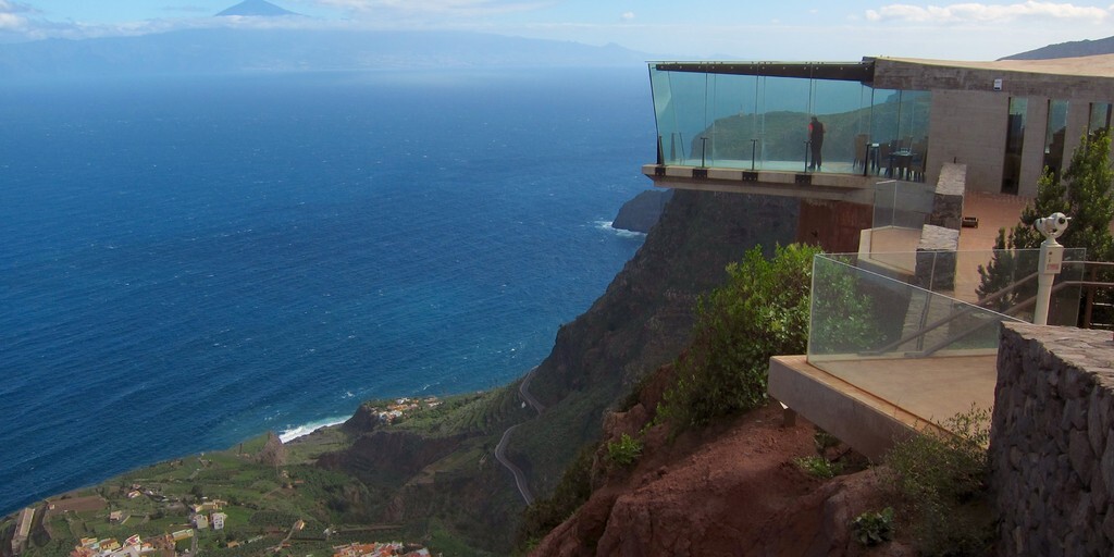
Mirador de Abrante. At first glance, Abrante seems like a typical viewpoint. However, atop the cliff in the north of La Gomera, where the viewpoint is located, visitors not only have a view of the steep rock, but also "float" above it. At the end of the viewpoint is a seven-meter-high overhang with a glass floor. Those who dare to walk on it are practically suspended in the air, taking in the rural landscape typical of the Canary Islands. There's also a restaurant here where you can enjoy a drink.
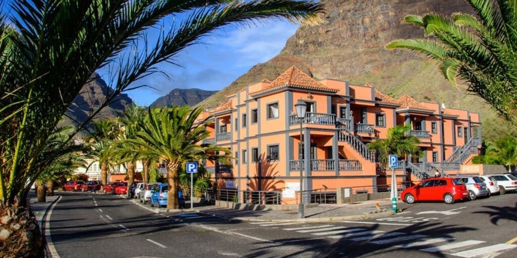
We then drive to the small town of Valle Gran Rey. It's a bit busier here than the rest of the island, but it's cozy, relaxed, and friendly, making it a good place to take a break and stretch your legs or have a drink or a bite to eat in one of the many restaurants or bars.
We return a short distance along the same road, then turn right into Garajonay National Park. There's an Information Center about the park and a small restaurant-bar, Laguna Grande, where you can get information and enjoy a bite to eat and a drink. Those who enjoy it can take a short walk through the beautiful natural surroundings.
We continue the journey back to the port to make the crossing to Tenerife.
 Links
Links  Usage
Usage Want to download this route?
You can download the route for free without MyRoute-app account. To do so, open the route and click 'save as'. Want to edit this route?
No problem, start by opening the route. Follow the tutorial and create your personal MyRoute-app account. After registration, your trial starts automatically.  Disclaimer
Use of this GPS route is at your own expense and risk. The route has been carefully composed and checked by a MyRoute-app accredited RouteXpert for use on TomTom, Garmin and MyRoute-app Navigation.
Changes may nevertheless have occurred due to changed circumstances, road diversions or seasonal closures. We therefore recommend checking each route before use.
Preferably use the route track in your navigation system. More information about the use of MyRoute-app can be found on the website under 'Community' or 'Academy'.

Canary Islands
About this region
The Canary Islands (; Spanish: Canarias, pronounced [kaˈnaɾjas]), also known informally as the Canaries, is a Spanish archipelago in the Atlantic Ocean, in a region known as Macaronesia. At their closest point to the African mainland, they are 100 kilometres (62 miles) west of Morocco. They are the southernmost of the autonomous communities of Spain, and are located in the African Tectonic Plate. The archipelago is economically and politically European, and is part of the European Union.The eight main islands are (from largest to smallest in area) Tenerife, Fuerteventura, Gran Canaria, Lanzarote, La Palma, La Gomera, El Hierro and La Graciosa. The archipelago includes many smaller islands and islets, including Alegranza, Isla de Lobos, Montaña Clara, Roque del Oeste, and Roque del Este. It also includes a number of rocks, including those of Salmor, Fasnia, Bonanza, Garachico, and Anaga. In ancient times, the island chain was often referred to as "the Fortunate Isles". The Canary Islands are the southernmost region of Spain, and the largest and most populous archipelago of Macaronesia. Because of their location, the Canary Islands have historically been considered a bridge between the four continents of Africa, North America, South America, and Europe.In 2019, the Canary Islands had a population of 2,153,389, with a density of 287.39 inhabitants per km2, making it the eighth most populous autonomous community of Spain. The population is mostly concentrated in the two capital islands: around 43% on the island of Tenerife and 40% on the island of Gran Canaria.
The Canary Islands, especially Tenerife, Gran Canaria, Fuerteventura, and Lanzarote, are a major tourist destination, with over 12 million visitors per year. This is due to their beaches, tropical to subtropical climate, and important natural attractions, especially Maspalomas in Gran Canaria, Teide National Park, and Mount Teide (a World Heritage Site) in Tenerife. Mount Teide is the highest peak in Spain and the third tallest volcano in the world, measured from its base on the ocean floor. The islands have warm summers and winters warm enough for the climate to be technically tropical at sea level. The amount of precipitation and the level of maritime moderation vary depending on location and elevation. The archipelago includes green areas as well as desert areas. The islands’ high mountains are ideal for astronomical observation, because they lie above the temperature inversion layer. As a result, the archipelago boasts two professional observatories: Teide Observatory on the island of Tenerife, and Roque de los Muchachos Observatory on the island of La Palma.In 1927, the Province of Canary Islands was split into two provinces. In 1982, the autonomous community of the Canary Islands was established. The cities of Santa Cruz de Tenerife and Las Palmas de Gran Canaria are, jointly, the capital of the islands. Those cities are also, respectively, the capitals of the provinces of Santa Cruz de Tenerife and Las Palmas. Las Palmas de Gran Canaria has been the largest city in the Canaries since 1768, except for a brief period in the 1910s. Between the 1833 territorial division of Spain and 1927, Santa Cruz de Tenerife was the sole capital of the Canary Islands. In 1927, it was ordered by decree that the capital of the Canary Islands would be shared between two cities, and this arrangement persists to the present day. The third largest city in the Canary Islands is San Cristóbal de La Laguna (a World Heritage Site) on Tenerife. This city is also home to the Consejo Consultivo de Canarias, which is the supreme consultative body of the Canary Islands.During the Age of Sail, the Canaries were the main stopover for Spanish galleons on their way to the Americas, which sailed that far south in order to catch the prevailing northeasterly trade winds.
Read more on Wikipedia
The Canary Islands, especially Tenerife, Gran Canaria, Fuerteventura, and Lanzarote, are a major tourist destination, with over 12 million visitors per year. This is due to their beaches, tropical to subtropical climate, and important natural attractions, especially Maspalomas in Gran Canaria, Teide National Park, and Mount Teide (a World Heritage Site) in Tenerife. Mount Teide is the highest peak in Spain and the third tallest volcano in the world, measured from its base on the ocean floor. The islands have warm summers and winters warm enough for the climate to be technically tropical at sea level. The amount of precipitation and the level of maritime moderation vary depending on location and elevation. The archipelago includes green areas as well as desert areas. The islands’ high mountains are ideal for astronomical observation, because they lie above the temperature inversion layer. As a result, the archipelago boasts two professional observatories: Teide Observatory on the island of Tenerife, and Roque de los Muchachos Observatory on the island of La Palma.In 1927, the Province of Canary Islands was split into two provinces. In 1982, the autonomous community of the Canary Islands was established. The cities of Santa Cruz de Tenerife and Las Palmas de Gran Canaria are, jointly, the capital of the islands. Those cities are also, respectively, the capitals of the provinces of Santa Cruz de Tenerife and Las Palmas. Las Palmas de Gran Canaria has been the largest city in the Canaries since 1768, except for a brief period in the 1910s. Between the 1833 territorial division of Spain and 1927, Santa Cruz de Tenerife was the sole capital of the Canary Islands. In 1927, it was ordered by decree that the capital of the Canary Islands would be shared between two cities, and this arrangement persists to the present day. The third largest city in the Canary Islands is San Cristóbal de La Laguna (a World Heritage Site) on Tenerife. This city is also home to the Consejo Consultivo de Canarias, which is the supreme consultative body of the Canary Islands.During the Age of Sail, the Canaries were the main stopover for Spanish galleons on their way to the Americas, which sailed that far south in order to catch the prevailing northeasterly trade winds.
View region
 Statistics
  8
8Amount of RX reviews (Canary Islands)
 17404
17404Amount of visitors (Canary Islands)
 396
396Amount of downloads (Canary Islands)
 Route Collections in this region
 Exploring the magnificent roads of Gran Canaria in three days
Nog een weekje vakantie tegoed? En het snertweer zat? Op vier uur vliegen is het, in tegenstelling tot het wisselvallige Nederlandse weer, altijd zomer. En Gran Canaria kan dan wel bekend staan om de massa's zonaanbidders, het blijkt ook een waar walhalla voor de motorrijder!
Deze drie routes zijn prima in één weekend of midweek te rijden. Ze brengen je naar alle hoeken van het eiland waar het maar enigszins interessant is om te rijden. En laten we eerlijk zijn, dat is bijna het hele eiland! Laat je overweldigen door de fantastische krullende wegen, voorzien van strak asfalt, die over het eiland zijn aangelegd, laat je verrassen door de verborgen schatten die aan het massatoerisme voorbij gaan.
Op het eiland zijn meerdere verhuurders van motoren aanwezig waaronder Motor Rental Bike en Pic Y Poc. Voor het meest actuele aanbod en prijzen schiet je een zoekopdracht in bij Google, dan ben je vrijwel zeker dat de data niet verouderd is.
Per route worden in de review enkele bezienswaardigheden besproken. Deze vertellen vaak iets over de geschiedenis van het gebied waarin je rijdt. Leuke weetjes, best leerzaam. Het staat je geheel vrij om deze bezienswaardigheden te bezoeken, je kunt uiteraard ook je eigen interessante punten bepalen.
Maar het belangrijkste waar je waarschijnlijk voor bent afgereisd naar dit gebied, is het geweldige rijden en het schitterende weer. En zoals hierboven al is gezegd, je bevindt je in een waar motorparadijs waarin het fantastisch sturen is!
De routes van deze collectie:
Roundtour Gran Canaria day 1 West - 223km
Roundtour Gran Canaria day 2 North-East - 191km
Roundtour Gran Canaria day 3 South - 245km
Heel veel plezier bij het rijden van deze routes!
View Route Collection