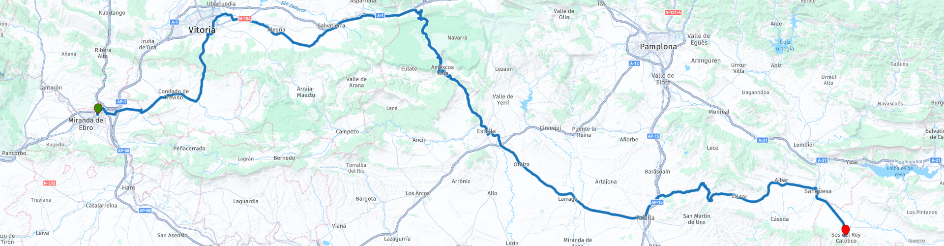
04 Miranda de Ebro to Sos del Rey Catolico

This route was brought to you by:
RouteXpert Nick Carthew - (MRA Master)
Last edit: 04-04-2025
 Route Summary
  Share this route


Animation

Verdict


Duration
6h 56m

Mode of travel
Car or motorcycle

Distance
220.81 km

Countries

 RouteXpert Review
 On leaving the hotel, you can't help noticing the silhouette of a large bull by the roadside. The image of the Osborne bull in Spain is widely recognized, as of July 2022 there are 92 of them installed on hilltops and along roadways throughout much of Spain. The bull was originally conceived as an outdoor advertisement for the Brandy de Jerez made by the Osborne Group in 1956. With the passage of time, the Osborne bull has become a national symbol of Spain.
When we did this tour in 2016, we passed field after field of wheat, so this is obviously the grain growing area of Spain.
We stopped in Vittoria to visit a Burger King for a quick coffee and to buy some provisions for a picnic from the Carrefour Market.
After Vittoria you are soon on pleasant rural roads heading towards the Parque Natural de Urbasa-Andia at Olazaguti.
You can then see the higher ground as you approach and the road gets steeper and twistier the further you go with several hairpin bends. We stopped on one of these bends for a photo and we saw Griffon Vultures soaring overhead as well as Peregrine Falcons. Once you have ascended the limestone cliff, there is a plateau with shady beech trees providing an excellent spot to stop for your picnic. The higher altitude and shade from the trees meant that we could cool off and chat about all those hairpins we had just ridden!
On the far side of the plateau you can park up to visit the Mirador de Ubaba. A 500m walk takes you to the Pilatos Balcony or Ubaba viewpoint. The cliff or precipice forms a semi-circular rock circus 300 meters high. The cliff walls are the habitual habitat of vultures and white vultures and the views are breathtaking.
Then what goes up must come down and so you are treated to more twisties as you descend. You reach the small village of Zudaire which is actually built around 2 beautifully swooping hairpin bends!
Gradually the route transforms, the temperature (if you are riding in summer) increases as you reach the vast open plains we decided to stop for a refreshing drink in Estella, a town of great monumental and religious heritage on the Camino de Santiago. Aymeric Picaud, author of the Pilgrim's, wrote of Estella that, 'Estella is a city of good bread, great wine, lots of meat and fish, and all kinds of happiness'. Founded in 1090 by King Sancho Ramirez, the town is a wonderful destination for lovers of art, history and monumental heritage. Parking was easy and there were bars on the other side of the road.
The roads become straighter but there is a charm to the countryside with the route bordered by wheat fields with poppies. An hour or so later and we found refuge from the heat in Sanguesa with its streets of very tall stone buildings providing shaded tables and bars with refreshing, tangy, homemade lemonade with lots of ice. The end destination of Sos del Rey Católico (a fortified hilltop village) is just 15 minutes away and soon becomes visible as it is perched on top of a hill, like an island in the flat plain. Charming place for an overnight stop with narrow streets to walk, bars and restaurants. As it is a walled town you have to park outside and walk into the medieval centre but it is not much of a hardship as the architecture is stunning in it’s antiquity. Our B&B for the night was The Infanzon which was small but very comfortable and a good breakfast in the morning. A link to the B&B is below.
Enjoy


 Links
Links  Usage
Usage Want to download this route?
You can download the route for free without MyRoute-app account. To do so, open the route and click 'save as'. Want to edit this route?
No problem, start by opening the route. Follow the tutorial and create your personal MyRoute-app account. After registration, your trial starts automatically.  Disclaimer
Use of this GPS route is at your own expense and risk. The route has been carefully composed and checked by a MyRoute-app accredited RouteXpert for use on TomTom, Garmin and MyRoute-app Navigation.
Changes may nevertheless have occurred due to changed circumstances, road diversions or seasonal closures. We therefore recommend checking each route before use.
Preferably use the route track in your navigation system. More information about the use of MyRoute-app can be found on the website under 'Community' or 'Academy'.

Castile and León
About this region
Castile and León (UK: , US: ; Spanish: Castilla y León [kasˈtiʎa i leˈon] (listen); Leonese: Castiella y Llión [kasˈtjeʎa i ʎiˈoŋ]; Galician: Castela e León [kasˈtɛlɐ ɪ leˈoŋ]) is an autonomous community in north-western Spain.
It was created in 1983. Formed by the provinces of Ávila, Burgos, León, Palencia, Salamanca, Segovia, Soria, Valladolid and Zamora, it is the largest autonomous community in Spain in terms of area, covering 94,222 km2. It is however sparsely populated, with a population density below 30/km2. While a capital has not been explicitly declared, the seats of the executive and legislative powers are set in Valladolid by law and for all purposes that city (also the most populated municipality) serves as de facto regional capital.
Castile and León is a landlocked region, bordered by Portugal as well as by the Spanish autonomous communities of Galicia, Asturias, Cantabria, the Basque Country, La Rioja, Aragon, Castilla–La Mancha, the Community of Madrid and Extremadura. Chiefly comprising the northern half of the Inner Plateau, it is surrounded by mountain barriers (the Picos de Europa to the North, the Sistema Central to the South and the Sistema Ibérico to the East) and it is drained by the Douro River, flowing west toward the Atlantic Ocean.
The region contains eight World Heritage Sites. UNESCO recognizes the Cortes of León of 1188 as the cradle of worldwide parliamentarism.
Read more on Wikipedia
It was created in 1983. Formed by the provinces of Ávila, Burgos, León, Palencia, Salamanca, Segovia, Soria, Valladolid and Zamora, it is the largest autonomous community in Spain in terms of area, covering 94,222 km2. It is however sparsely populated, with a population density below 30/km2. While a capital has not been explicitly declared, the seats of the executive and legislative powers are set in Valladolid by law and for all purposes that city (also the most populated municipality) serves as de facto regional capital.
Castile and León is a landlocked region, bordered by Portugal as well as by the Spanish autonomous communities of Galicia, Asturias, Cantabria, the Basque Country, La Rioja, Aragon, Castilla–La Mancha, the Community of Madrid and Extremadura. Chiefly comprising the northern half of the Inner Plateau, it is surrounded by mountain barriers (the Picos de Europa to the North, the Sistema Central to the South and the Sistema Ibérico to the East) and it is drained by the Douro River, flowing west toward the Atlantic Ocean.
The region contains eight World Heritage Sites. UNESCO recognizes the Cortes of León of 1188 as the cradle of worldwide parliamentarism.
View region
 Statistics
  29
29Amount of RX reviews (Castile and León)
 14371
14371Amount of visitors (Castile and León)
 2523
2523Amount of downloads (Castile and León)
 Route Collections in this region
 Three tours in and around Picos de Europa Northern Spain
The Picos de Europa is a mountainous area in northern Spain, next to the Basque Country. In the middle is the village of Posada de Valdeon, which cannot be reached by motorbike from the north: you have to drive around the Picos via Potes or Sames. We stayed overnight in Posada de Valdeon in Hostal Casa Abascal. A great hotel with breakfast option. You can eat in a restaurant in the village with usually a choice of two menus.
There are all kinds of nature reserves around the Picos. These three routes take you through some of them. There are gorges to see, viewpoints, reservoirs and you can walk more than fine. If you like walking, bring your walking shoes.
But we come to ride and it's going great. Excellent roads with the occasional piece of unpaved so that you do not have to detour far for another attraction. You can eat delicious food and the people are very nice and hospitable. And because the route to Lourdes goes above the Picos, there are also pilgrimage sites and very beautiful churches and monasteries. The most beautiful thing in this area is the nature: breathtakingly beautiful with wild animals, rugged mountains and wild rivers.
All in all, you can spend at least 4 days here if you take a day of rest or go for a walk.
View Route Collection
A 4 day tour in Spain from Bilbao to Cartagena
With a starting point just south of Bilbao, this 1,300 km tour is easy to connect to from the French border or Santander. The tour travels through some of Spain's most spectacular landscapes and visits among other things, the windmills of La Mancha, made famous in the books by Miguel de Cervantes and his character Don Quixote. The end of this 4 day tour is at Cartagena on the Mediterranean's Costa Cálida, a wonderful city that's alive with culture, history and gastronomy.
View Route Collection