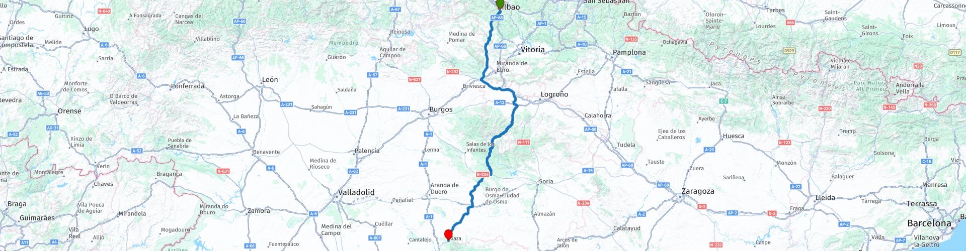
01 Bilbao to Riaza

This route was brought to you by:
RouteXpert Nick Carthew - (MRA Master)
Last edit: 14-02-2022
 Route Summary
 This first route travels through 4 Spanish provinces and several natural parks using a mixture of roads. The landscapes include, pine forests, arable farmland and mountains. A series of 7 hairpin bends quickly climb the 900m Sierra Salvada offering superb views at various points.
The varied roads and landscapes earn this route 4**** stars.
 Share this route


Animation

Verdict


Duration
7h 40m

Mode of travel
Car or motorcycle

Distance
321.11 km

Countries

 RouteXpert Review
 Follow the River Nervión south, away from Bilbao and into an open landscape with heavily wooded hillsides on a good, fast road that takes you to the Sierra Salvada mountain range.
The Sierra Salvada has a steep and dramatic north slope with exposed rock cliffs. These rock walls are the nesting place for rock-breeding birds including the Egyptian vulture, griffon vulture, peregrine falcon, yellow-billed chough, red-billed chough, alpine swift, rufous-tailed rock thrush and the alpine accentor. A series of hairpin bends takes you to the summit with great viewpoints for some of the best places to see these birds.
The gentle southern slope down is less dramatic but no less a beautiful landscape. The rivers Tumecillo and Omecillo take you through fertile arable farmland where crops of wheat and sunflowers can be seen.
Standing on the plains of the River Ebro, dotted with beech, holm and gall oak woods that stand out against the clearly-traced backdrop of the Obarenes mountain range, is the picturesque medieval village called Santa Gadea del Cid. The 10th centaury castle is clearly visible as you arrive. Founded as a stopping point on the road from Aquitaine to Astorga, during the medieval period it provided essential communication with the northern regions and today makes an interesting place for a coffee break.
The arrow straight road leaving the village marks the eastern edge of the Parque Natural Montes Obarenes that boasts a wealth of treasures including the mountain ranges of Oña, la Llana, Pancorbo, Arcena and the Obarenes mountains themselves some of the final foothills of the Cantabrian Mountains.
Just 10 minutes on from the village and you'll travel through the spectacular Pancorbo Gorge.
An isolated bell tower set high on a rocky outcrop marks the beginning of the gorge. This is associated with the Ermita Virgen del Camino, a hermitage dedicated to travellers at road level below the bell.
The Desfiladero de Pancorbo is the historic route through the Obarenes Mountains, separating the north of Spain and the Castilian Plateau. It has played an important defensive role stretching back to at least Morrish times, and probably Roman and pre-Roman. Latterly, during the Peninsular War, it was here that the Spanish army under the command of Lieutenant General Joaquin Blake slowed the advance of Napoleon’s army towards Madrid, so its vigilance and defense has always been important, as the remains of several fortifications in its environment testify. For bird lovers, there is a well established colony of griffon vultures to look out for. The 141m long Pancorbo Tunnel marks the end of the gorge and is faced with stonework that resembles a castle as a nod to the fortifications in the area.
The route now enters into the La Rioja region, the land is used for cereal, sugar beet and potatoes, while the hills are covered with vast vineyards for the wine that has brought worldwide fame to this region.
The route now follows the Najerilla river valley.
The Najerilla River flows from the mountains of the Sierra de la Demanda to the Ebro River making this a special corner of La Rioja, with a unique style of wine, the lower part of the valley yielding the region’s most balanced wines. The valley, considered by many to be central to La Rioja vineyards and is one of the Seven Valleys of the Rioja. The Najerilla valley has the greatest number of acres dedicated to wine growing in the Rioja Alta, some are ancient terraces carved out of the hills higher up in the valley. Because the road follows the mountain river closely, there are many twists and turns with steep hills either side. You'll pass two reservoirs, first is the smaller Piarrejas Reservoir and then the much larger Mansilla Reservoir, stop for a photo from the dam that holds back 68 million cubic meters of water of the Najerilla River.
Work started on the Mansilla Reservoir in 1935 but due to the civil war a year later, the project took 25 years to complete. The Franco government decided to flood the old town of Mansilla since the other option for this reservoir involved a new road layout, which would be more expensive. When the water level is low the eerie remains old town can be seen.
At Villavelayo you'll turn away from the Najerilla River and follow one of it's tributaries, the River Neila on another fantastic twisty road to the town that shares the river name and then onto the highest point of this route at 1410m and the border of the Sierra de la Demanda Natural Park. The peaks in the park are often covered in snow while lower elevations are covered in lush forests of Beech, oak, and rebello trees are interspersed with patches of Scots pine. The park is known for its animal biodiversity and is home to a recovering population of wolves.
I suggest a lunch stop in Quintanar de la Sierra, a town that grew prosperous by the manufacture of wooden carts. There is a good choice of restaurants, cafes and bars.
After lunch, the route travels through pine forests and the Canyon of the Rio Lobos Natural Park. It is home to dense forest masses of junipers and cluster pines as well as a wealth of fauna, including pairs of griffon vultures. It is also an important reserve for golden eagles, Egyptian eagles and falcons. The mammals include large numbers of deer, boars, squirrels, otters, badgers and wildcats.
The landscape now levels out and forests are replaced with fields of cereal with the occasional olive grove.
A castle stands prominent on the approach to San Esteban de Gormaz.
The castle of San Esteban de Gormaz is one of the mythical castles of the high Middle Ages that defended the passage of the Duero river, sometimes for Muslims and sometimes for Christians. This castle was not as important or recognized as Gormaz (30 kilometers from San Esteban), but it's people who defended the bridge that crosses the Duero river, a powerful natural border between Muslim and Christian lands were.
Unfortunately, especially with the French invasion of 1808, the Castle suffered major damage. In 1914 the government subsidised the demolition of part of the castle that threatened to fall and cause a disaster in the cellars and houses that were under it. Even so, the detonations did not take place as planned and the demolition spiraled out of control. It sank the roofs of various houses destroying them and even caused damage to the town hall itself!
The N-110 is a fast road through an agricultural landscape that will take you to the end of this route at Riaza just 30 minutes away.
It is virtually impossible not to go through the beautiful “Plaza Mayor” of Riaza, given that a lot of streets connect there and this is where this first route of a tour through Spain ends. The square grabs your attention because it is in the form of an ellipse, because of its stone steps joined by cast iron rails, its porticos, continuous balconies, the irregular height of its buildings…The renaissance style Church of Nuestra Señora del Manto is nearby. It is an imposing figure because of, among other things, its 33 meter high bell tower. There is plenty of options for accommodation from hotels to camping, I’ll add links to a few below this review.
Enjoy.


 Links
Links  Usage
Usage Want to download this route?
You can download the route for free without MyRoute-app account. To do so, open the route and click 'save as'. Want to edit this route?
No problem, start by opening the route. Follow the tutorial and create your personal MyRoute-app account. After registration, your trial starts automatically.  Disclaimer
Use of this GPS route is at your own expense and risk. The route has been carefully composed and checked by a MyRoute-app accredited RouteXpert for use on TomTom, Garmin and MyRoute-app Navigation.
Changes may nevertheless have occurred due to changed circumstances, road diversions or seasonal closures. We therefore recommend checking each route before use.
Preferably use the route track in your navigation system. More information about the use of MyRoute-app can be found on the website under 'Community' or 'Academy'.

La Rioja
About this region
La Rioja (UK: , US: , Spanish: [la ˈrjoxa]) is an autonomous community and province in Spain, in the north of the Iberian Peninsula. Its capital is Logroño. Other cities and towns in the province include Calahorra, Arnedo, Alfaro, Haro, Santo Domingo de la Calzada, and Nájera. It has an estimated population of 315,675 inhabitants (INE 2018), making it the least populated region of Spain.
It covers part of the Ebro valley towards its north and the Iberian Range in the south. The community is a single province, so there is no County Council, and it is organized into 174 municipalities. It borders the Basque Country (province of Álava) to the north, Navarre to the northeast, Aragón to the southeast (province of Zaragoza), and Castilla y León to the west and south (provinces of Burgos and Soria).
The area was once occupied by pre-Roman Berones, Pellendones and Vascones. After partial recapture from the Muslims in the early tenth century, the region became part of the Kingdom of Pamplona, later being incorporated into Castile after a century and a half of disputes. From the eighteenth century the Rioja region remained divided between the provinces of Burgos and Soria, until in 1833 the province of Logroño was created, changing the name of the province to La Rioja in 1980 as a prelude to its constitution under a single provincial autonomous community in 1982. The name "Rioja" (from Río Oja) is first attested in 1099.
The region is well known for its wines under the brand Denominación de Origen Calificada Rioja.
Read more on Wikipedia
It covers part of the Ebro valley towards its north and the Iberian Range in the south. The community is a single province, so there is no County Council, and it is organized into 174 municipalities. It borders the Basque Country (province of Álava) to the north, Navarre to the northeast, Aragón to the southeast (province of Zaragoza), and Castilla y León to the west and south (provinces of Burgos and Soria).
The area was once occupied by pre-Roman Berones, Pellendones and Vascones. After partial recapture from the Muslims in the early tenth century, the region became part of the Kingdom of Pamplona, later being incorporated into Castile after a century and a half of disputes. From the eighteenth century the Rioja region remained divided between the provinces of Burgos and Soria, until in 1833 the province of Logroño was created, changing the name of the province to La Rioja in 1980 as a prelude to its constitution under a single provincial autonomous community in 1982. The name "Rioja" (from Río Oja) is first attested in 1099.
The region is well known for its wines under the brand Denominación de Origen Calificada Rioja.
View region
 Statistics
  4
4Amount of RX reviews (La Rioja)
 13877
13877Amount of visitors (La Rioja)
 134
134Amount of downloads (La Rioja)
 Route Collections in this region
 A 4 day tour in Spain from Bilbao to Cartagena
With a starting point just south of Bilbao, this 1,300 km tour is easy to connect to from the French border or Santander. The tour travels through some of Spain's most spectacular landscapes and visits among other things, the windmills of La Mancha, made famous in the books by Miguel de Cervantes and his character Don Quixote. The end of this 4 day tour is at Cartagena on the Mediterranean's Costa Cálida, a wonderful city that's alive with culture, history and gastronomy.
View Route Collection