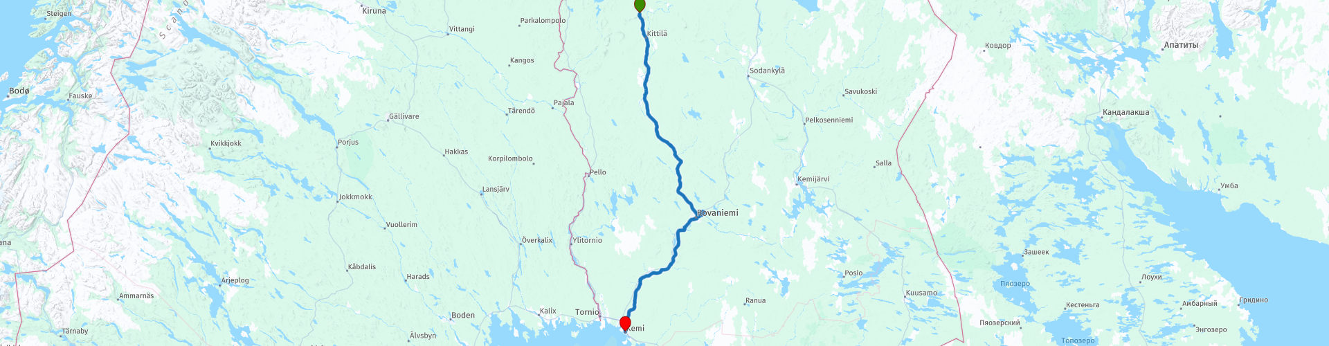
R20 Sirkka to Kemi

This route was brought to you by:
RouteXpert Arno van Lochem - RouteXpert
Last edit: 20-05-2021
 Route Summary
 In Sirkka they received the coordinates of the next stop: The ferry in Turku.
The routes are easy for everyone to drive and are on well-paved roads. It may be necessary to take a single hairpin bend, but these are perfectly doable.
If there is a piece of gravel in the route, a warning will be given and, if possible, a detour will be indicated.
The route starts in Sirkka. Along the way fantastic landscapes, lots of water and beautiful views, making the road great. Nice to drive. After every turn a different fantastic view. Beautiful and interesting sights include the Einari Junttila and Palsa museums in Kittilä, the Molkoköngäs rapids, Santa's office and the beautiful natural phenomenon Hiidenkirnut.
There are not too many catering establishments, which is why it is better to ensure that you have something to eat and drink with you for the road.
The route is 300 kilometers long, a shorter route is indicated, but that does mean that you will drive on gravel for large parts. Please note that this shorter route contains few facilities such as petrol stations or restaurants along the way. So make sure you have a well-filled tank and something to eat and drink on the go.
In Sirkka, the participants of the Arctic Challenge were told the coordinates of the next destination: Turku in the south of Finland. Ride of over 1000 kilometers ...
Beautiful rugged landscape, beautiful scenic views, tight roads and beautiful sights, hence the 4-star rating.
 Share this route


Animation

Verdict


Duration
7h 54m

Mode of travel
Car or motorcycle

Distance
301.62 km

Countries

 RouteXpert Review
 Of all western European countries, the Scandinavian countries probably have the most more or less untouched nature. In addition, they are countries that are easily accessible from the Netherlands. Norway is characterized by, among other things, the fjords and the Trollstigen known to many motorcyclists. And where Sweden is known as wide and peaceful, everyone knows Finland as the land of 1000 lakes. All in all, legitimate reasons to traverse this beautiful nature in the north of Europe by means of a number of routes.
After visiting the great highlights of this tour, it is time to head south again. The route starts in Sirkka, a lively winter sports resort in the north of Finland.
Just outside the village you will pass a gas station where you can fill the tank if necessary. You can also buy some food and drinks in the shop for on the go. Although there is a reasonable opportunity to stop for food and / or drinks along the way, it is also possible to shorten the route a bit. You will then come across various pieces of gravel. However, this road is quite remote and you will not encounter many catering establishments.
When you arrive in Kittilä you have the opportunity to visit two museums. First, here you will find the The Einari Junttila Art Museum. This museum is located in a house built by the artist in the 1930s. The native Kittilä artist Einari Junttila (1901-1975) is best known for his watercolors depicting the nature of Lapland. Opened in 1991, the museum showcases his art and home environment. The museum is owned and maintained by Einari Junttila's daughter, Terttu Junttila.
You will also find the Palso museum in this place. It includes the cottage and studio of Kalervo Palsa (1947-1987). The artist's father Hugo Palsa bought a small farm called Hyrynkangas in 1946 and it is one of the few surviving buildings in the church village of Kittilä that survived the devastation of the Lapland War. The museum is open from the beginning of June to the end of September,
Kalervo Palsa lived in the cottage with his parents and three brothers. Mother Hilja Kenttälä earned extra income for the family by selling liquor and sheltering men working in the area. At a young age, the existing courtyard became an important place for Kalervo Palsa, where he was allowed to write and paint his diary in peace. He called his bare studio Cloud Castle and Gethsemane. The last years of his life Palsa lived there alone, after the death of his mother and brother. On October 4, 1987, he died in his studio after contracting pneumonia.
The Palsa Museum in the center of Kittilä opened on June 6, 2013. The house was uninhabited since the artist's death and has fallen into disrepair. The Kauko Sorjonen Foundation acquired Palsa buildings and furniture in 2011, and restoration work was carried out the following year. In connection with the work, the paintings on the walls of the studio in Gethsemane have also been preserved.
Although not everywhere in sight, you drive the first 170 kilometers of the route along the Ounasjoki. The Ounasjoki is the largest tributary of the Kemijoki River and at the same time the longest tributary in Finland. It is also the largest undeveloped river that lies entirely within Finland's borders. The river is approximately 300 kilometers long and has a catchment area of 13,968 km² - 27% of the Kemijoki catchment area.
The Ounasjoki has been an important waterway and has been used by many river inhabitants. The area has been inhabited for 8,000 years, as evidenced by the wooden deer head sculpture in Lake Lehtojärvi. Before deploying, Ounasjoki was one of the best salmon rivers in Finland. The Sámi, who lived along the river in ancient times, got a lot of fish from the river. They also herded and hunted reindeer. Until the early 17th century, the King of Sweden had forbidden the Finns to move to Lapland. After the ban was lifted, the Finns began to move. The abundant fishing of Ounasjoki attracted people to move to the Ounasjoki from other parts of Finland. Newcomers cleared meadows along the river into fields and set up farms. In this way, the riverbank was permanently inhabited and the natives were forced further and further north.
Several rapids can be seen in this river, one of which is Molkoköngäs. A great point to stop, stretch your legs and enjoy the great spectacle in the river.
The first 170 kilometers of this route you are still within the Arctic Circle. At Rovaniemi you will leave it, and in a special place. Someone we all know has his office there: Santa Claus! You can visit this (commercially set up) attraction, but it is still nice to see how it is decorated. Everything is in the spirit of Santa Claus, all year round!
Just south of Rovaniemi you have the opportunity to view a beautiful natural phenomenon, Hiidenkirnut. This is a cylindrical well in the rock. Hiidenkirnut is formed by the melt water from glacial glaciers that spin a large rock or rocks, grindstone or whirlstones in place, carving fairly symmetrical cavities with smooth edges in the rock. The current must have been strong enough to keep the smaller rocks away, and high enough for other heavy rocks to pass the emerging Kirnu from elsewhere in the deeper parts of the stream and not block the resulting kirnu. The depth of Hiidenkirnus can be several meters. Many hiidenkirnu have a sharpening stone at the bottom.
Not much research has been done on hiidenkirnu in Finland or elsewhere in the world, so the exact number of hiidenkirnu in the world or even in Finland is not known.
Please note that from the main road you have to drive on a gravel road for two kilometers to get to Hiidenkirnut.
The end point of this 300-kilometer route is the Merihoviovi Hotel in Kemi. This is a hotel with a good rating. Bar and restaurant are present again, so the debriefing while enjoying a beer is no problem here either. There is also a sauna.
For campers, two campsites are indicated in the vicinity of the end point: Savotta Camping and Pohjanranta.
If you still have time to spare, you can visit the Kemi Gemstone Gallery. The gemstone gallery showcases a unique collection of raw and jewelery stones from different parts of the world. On the first floor of the exhibition there are more than 3000 different stones from more than 60 countries. The second floor of the gemstone gallery showcases replicas of the world's most famous diamonds and crown jewels, such as the United Kingdom's imperial state crown, the spheres of the Norwegian king and queen, a Russian imperial scepter from the 1770s and a necklace of the French queen Marie Antoinette from the late 18th century. The gallery's self-righteous star is the authentic crown of the King of Finland!
The Kemi Comics Exhibition can also be visited in the same museum. The exhibition showcases the handiwork of more than 30 cartoonists, including originals, figurines and videos. The Kemi Comics Center also has a comic collection that consists of thousands of albums. The collection is large even on the scale of the Scandinavian countries and is now - as part of the new exhibition - for everyone to see and read for the first time.


 Links
Links  Usage
Usage Want to download this route?
You can download the route for free without MyRoute-app account. To do so, open the route and click 'save as'. Want to edit this route?
No problem, start by opening the route. Follow the tutorial and create your personal MyRoute-app account. After registration, your trial starts automatically.  Disclaimer
Use of this GPS route is at your own expense and risk. The route has been carefully composed and checked by a MyRoute-app accredited RouteXpert for use on TomTom, Garmin and MyRoute-app Navigation.
Changes may nevertheless have occurred due to changed circumstances, road diversions or seasonal closures. We therefore recommend checking each route before use.
Preferably use the route track in your navigation system. More information about the use of MyRoute-app can be found on the website under 'Community' or 'Academy'.