MTG2 09 Roundtrip Auvergne Nebouzat Orcival Monts Dore Murol Puy de Drome

This route was brought to you by:
RouteXpert René Plücken (MRA Master)
Last edit: 29-05-2021
 Route Summary
 This route comes from Motortourgids France part 2 and the original name is "Auvergne Directions 1: Puy de Dôme".
In Motorbike guide France part 2 a difference has been made between approach routes and trips in a certain area. The approach routes can also be used in combination with the routes from Motortourgids France part 1
The routes are sometimes slightly adjusted based on the tips that Bert Loorbach gives in his description, or because of a different place to spend the night, or to achieve the minimum length of 2 hours for the MRA Library. For each route there is a more detailed description in the review, including options to stay overnight or places of interest en route, which are also indicated with a POI and if possible with a short description
The route is made suitable for Garmin, TomTom, Harley-Davidson BoomBox 2019 and Navigation App, can be downloaded for free and without My-Route-app registration. To do this, first click on the 'Use route' button and then on 'Save as'.
 Share this route


Animation

Verdict


Duration
6h 42m

Mode of travel
Car or motorcycle

Distance
117.19 km

Countries

 RouteXpert Review
 In this landscape where the volcanoes play the leading role is the unique landscape shaped by the Magma. This is very different from the Alps or the Pyrenees that were caused by the severe earthquakes.
Motorcycling is an experience here, which you can do best in this area from June to September. Because of the craters, the unspoiled landscape and the clear sky, you have the feeling of going back in time.
There is no end to great curves here! There are many campsites and sufficient campsites in this area, so finding a place to stay should not be a problem.
The review shows the links of the other two routes in this area.
This is the review of the first route from a series of three that meanders through the Auvergne.
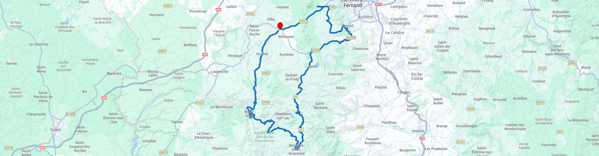
The campsite Les Dômes campsite in Nébouzat, near the "Puy de Dôme", this 1464m high volcano, is one of the "youngest" volcanoes in this area and is only ten kilometers from the center from Clermont-Ferrand. The volcano is part of a chain of old “Chaîn des Puys” volcanoes that run west past Clermont-Ferrand, some of these volcanoes are rounded off, such as the Puy de Dôme, and some are hollow. This has to do with the way the lava came out. With the spherical “dômes” the lava became hard as it came out and formed a sphere with no visible crater. With the hollow specimens such as the "Puy de la Vache", some ten kilometers to the south, the lava came up with great force and took part of the top with it.
There are also examples of volcanoes in a volcano, for example the "Puy de Pariou". Here a new crater appeared, already seen near the "Puy de Dôme". You can drive all the way to the top of the "Puy de Dôme" on a steep toll road "Route du Puy de Dôme", this costs a few euros. Another option is to go on foot or by train.
This used to be a holy place for the Celts, the Gauls and then for the Romans. They built a huge temple from fifty types of stone for Mercury. The remains of this can still be seen. The view is grandiose. From here you can look across eleven departments in clear weather. Those who want to enjoy it optimally can visit the top by nightfall. The play of sun, light and clouds is at its best. So we plan the ride to the top at the end of this route.
We start the engines and take the D216 from Camping Les Dômes and drive to the beautiful town of Orcíval (RP2) where you can visit the Basilica Notre-Dame d'Orcival dedicated to Our Lady. We continue the journey further south on the winding D27 that turns into the D983 near the “Col de Guéry” (RP3). It is certainly worth stopping here to enjoy the view over the Col, the Lac de Guéry (which we also pass at RP4) and the twin rocks "Tuilière" and "Sanadoire".
We continue the ride and drive via Le Mont-Dore (RP5), a well-known thermal resort and a popular ski resort. It lies at an altitude of 1050 meters under the watchful eye of the "Puy de Sancy", with its 1885 meters the highest peak of the Monts-Dore and also of the central Massif. This is also the birthplace of the Dordogne River, which originated from two small streams, the Dore and the Dogne, which converge here on their way, gathering more and more water as one of the most famous rivers of France. You can choose to stop here for a cup of coffee.
On the next road the "Col de la Croix Saint-Robert" (RP6) to "Vallée-de-Chaudefour" it is again possible to let the sparks splash off the footrests. This pass lies in the mountains of the Monts-Dore, between the Puy de l'Angle and the Roc de Cuzeau and is bursting with wonderful curves. This valley with sharp granite rocks is formed by the glaciers and the streams. Now the silence reigns here and lonely birds of prey are circling high in the air. A rock is named after these birds "Le Rocher de L'Aigle" (Eagle Rock). From here you have a beautiful view of the valley and the Monts-Dore mountain range.
In “Vallée-de-Chaudefour” (RP7) you can choose to stop and walk in this beautiful park that has been classified as a "Réserve Naturelle Nationale" since 1991. The beautiful landscapes and remarkable biodiversity are unsurpassed: streams, waterfalls, grass meadows, glacier valleys and beautiful formations such as the "Crête du Coq" (Hanenkam) and the "Dent de la Rancune" (Tooth of the Rancune). If you enjoy a holiday in the great outdoors, then this unique natural park in Auvergne will certainly exceed your wildest expectations. An extra night in the neighborhood is an option to consider.
The next city that we visit is Besse-en-Chandesse (RP11), this is a pleasant place with a number of black houses built from lava. The best example of this is the Rue de Ia Boucherie. Stop here to stretch your legs and have a drink or eat in the many cafés or restaurants is definitely worth it.
After a short stop we continue to the town of Murol (RP13), which lies between forests, streams and near the beautiful lake of Chambon. Just outside the town lies the huge castle "Château de Murol" that seems disproportionate compared to the village. The 13th-century structure looks like an impregnable block of volcano stone and that was exactly the intention. The current intentions are more peaceful and consist of musical spectacles and simulated Medieval battles.
After this the route goes up again via the D213 to the Col de La Ventouse, this Col is located in the Massif Central, in the municipality of Aydat at an altitude of 964 m and forms the maximum height of the D213.
We turn here on the D2089 to continue, via the towns of Fontfreyde, St. Genès and Manson (the original route runs via Laschamp) to the Puy de Dômes (RP20) to enjoy the view and the sunset. We drive back to the campsite via the "Col de Ia Moreno" (RP21).
This route is breathtakingly beautiful, beautiful winding roads, volcanoes but also many forests and green meadows and nice towns and villages where you can stop for something to eat, drink or just soak up some culture. That's why I rate this route with 5 ***** stars.


 Links
Links  Usage
Usage Want to download this route?
You can download the route for free without MyRoute-app account. To do so, open the route and click 'save as'. Want to edit this route?
No problem, start by opening the route. Follow the tutorial and create your personal MyRoute-app account. After registration, your trial starts automatically.  Disclaimer
Use of this GPS route is at your own expense and risk. The route has been carefully composed and checked by a MyRoute-app accredited RouteXpert for use on TomTom, Garmin and MyRoute-app Navigation.
Changes may nevertheless have occurred due to changed circumstances, road diversions or seasonal closures. We therefore recommend checking each route before use.
Preferably use the route track in your navigation system. More information about the use of MyRoute-app can be found on the website under 'Community' or 'Academy'.