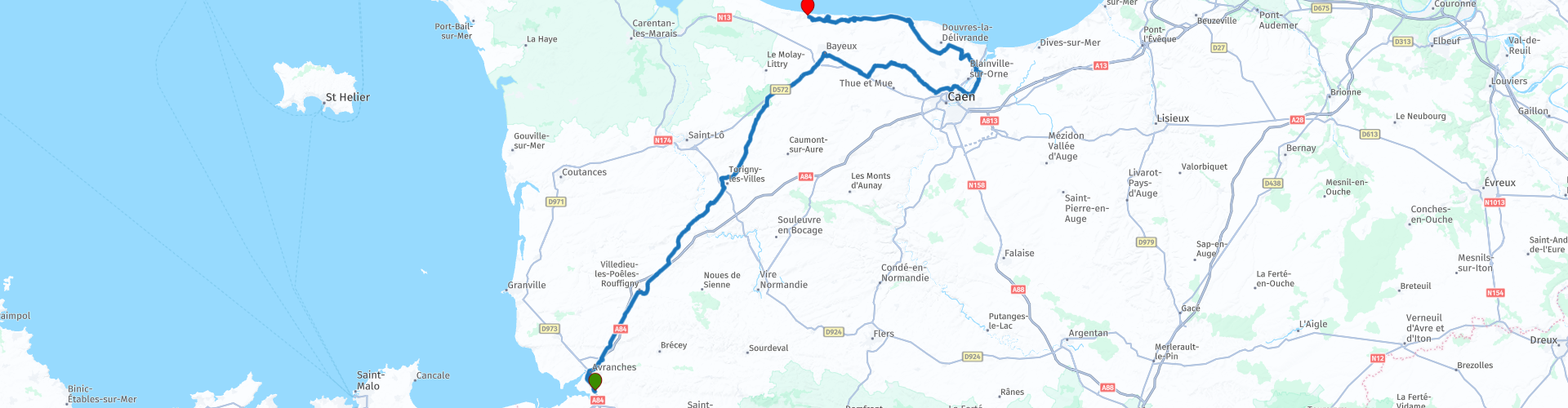
Avranches to Port en Bessin via Bayeux Tapestry and Pegasus Bridge

This route was brought to you by:
RouteXpert Nick Carthew - (MRA Master)
Last edit: 23-12-2020
 Route Summary
 This route uses mainly quiet rural roads with a short section of dual-lane motorway to pass the city of Caen.
The impressive sites that this route visits are why I have awarded it with 4**** stars.
 Share this route


Animation

Verdict


Duration
3h 22m

Mode of travel
Car or motorcycle

Distance
187.47 km

Countries

 RouteXpert Review
 The Bayeux Tapestry tells the epic story, in wool thread embroidered on linen cloth, of William, Duke of Normandy who became King of England in 1066 after the Battle of Hastings. Crossing the sea in longships, long cavalcades on horseback, shields and coats of mail, fantastic creatures and battlefields: all the details of a great medieval epic unfold before your eyes!
We parked our four motorcycles opposite the Bayeux Cathedral in between the railings and pavement and walked back the 200 metres to the entrance. The bikes were perfectly safe there. A link for the museum is below this review.
Next comes a short section of motorway to take you to and then around the periphery of Caen and then onto the Pegasus Bridge Museum.
This museum has to be the number one place to visit for a real taste of what it must have been like on Tuesday 6th June 1944. A link to their website is below this review.
The museum tells the story of the capture of Pegasus Bridge by British Glider-borne troops in June 1944. In advance of the D Day landings it was vital that the bridge at Benouville remained intact to ensure the advance of allied troops and so troops were sent by glider during the night to capture the bridge and prevent German troops from blowing it up. They then had to prevent any German counter-attack. The mission was a success and hence Benouville became the first town on the French mainland to be liberated.
It's a wonderful story and the museum tells it well with displays in French and English.
There are also memorials to Major John Howard and his men outside the museum at the spot where the gliders were deliberately crash-landed. The old bridge has now been replaced but the original once can be seen in the grounds of the museum.
You will leave the museum and travel over the modern replica of the Pegasus Bridge and you'll see Café Gondrée on your left. The owners of Café Gondrée were the first French civilians to be liberated at the start of the Normandy Landings. At the time of these events the café was run by Georges and Thérèse Gondrée. They had been involved in the French Resistance, and had passed on information about the defenses around the bridge to British intelligence through the French underground.
The Café Gondrée still serves as a café, though it is now known as the Pegasus Bridge Café. On 5 June 1987 it was listed as an Historical Monument.
You'll head to Juno Beach next.
Juno Beach was one of five beaches of the Allied invasion of German-occupied France. The beach spanned from Courseulles, a village just east of the British beach Gold, to Saint-Aubin-sur-Mer, and just west of the British beach Sword. Taking Juno was the responsibility of the Canadian Army, with sea transport, minesweeping, and a naval bombardment force provided by the Royal Canadian Navy and the British Royal Navy as well as elements from the Free French, Norwegian, and other Allied navies. The objectives of the 3rd Canadian Infantry Division on D-Day were to cut the Caen-Bayeux road, seize the Carpiquet airport west of Caen, and form a link between the two British beaches on either flank.
There is a memorial and museum The Juno Beach Centre that pays homage to the 45,000 Canadians who lost their lives during the War, of which 5,500 were killed during the Battle of Normandy and 359 on D-Day. It was opened in 2003 by veterans and volunteers with a vision to create a permanent memorial to all Canadians who served during the Second World War.
Along the coast now to Arromanches and the iconic Mulberry Harbour. Just before you reach Arromanches, you will see the sign on the right for the 360° cinema. The film is about 20 minutes long and you stand as you watch and listen to some really thought provoking actual footage of the Normandy Landings. Well worth a visit, a link for the cinema is below this review. You get a great view of the Mulberry Harbour from here or Port Winston as it became known.
Mulberry Harbour was perhaps the single greatest innovation that ensured victory for the Allies in the Battle of Normandy that followed D-Day. Without port facilities, the Allies would never have been able to build up their forces in France sufficiently to be able to withstand Germany’s efforts to defeat them.
Allied planners realised at an early stage that they would need a port facility very soon after arriving in France. Without one, all the men and materiel that would be needed to secure the beachhead, would have to be landed directly onto the captured beaches. This would necessitate using landing craft, which were relatively small and inefficient next to the facilities that a deep water port can offer.
However, a port would be hard to capture quickly, and there would be no guarantee that the German forces would not destroy the port before they abandoned it (indeed, most of the ports they abandoned were thoroughly wrecked by the time the Allies reached them).
The solution, in the eyes of Winston Churchill and several senior planners, was to take a port with them. A floating harbour that could be transported directly to France, and assembled off the beaches would ensure that sufficient facilities were in place to land large quantities of heavy equipment to supply the British, Canadian and American armies.
The plan called for two Mulberry harbours to be constructed at Normandy; Mulberry A at the American beach of Omaha and Mulberry B at Arromanches on the British Gold beach. With the beaches successfully captured, elements of Mulberry were towed to France as early as 6 June. Assembly began immediately and both harbours were operational within ten days, although amendments and expansions continued well into July.
Unfortunately a large storm struck the beaches on 18th and 19th of June. Mulberry A was almost totally destroyed and Mulberry B was not much better. The decision was made to abandon the American harbour and all the surviving elements were incorporated into Mulberry B. It was successfully reopened and renamed Port Winston. By October when it was officially closed, over 39,000 vehicles and 220,000 men were landed at the port.
Drop down the hill now and into Arromanches-Les-Bains itself. Here you'll find several gun emplacements and the Musée du Débarquement (Landing Museum) that will tell you even more about the Mulberry Harbour and Normandy Landings. Despite it's place in history, Arromanches is a typical seaside town with nice souvenir shops and plenty of places to grab a coffee.
Just 10 minutes further along the coast is the Longues-sur-Mer battery.
The German artillery battery at Longues-sur-Mer may not have been the most powerful in Normandy, but it was one of the best located to oppose the landings of 6 June 1944. Installed slightly back from the edge of a sixty-meter-high cliff, it was positioned directly opposite the Allied fleet and right between Omaha and Gold landing beaches.
This coastal battery, part of the Atlantic Wall coastal fortifications, was built by the German navy in the first half of 1944 and completed in four months. It consisted of four 150 mm guns in concrete bunkers, and one 120 mm gun. In May 1944 the battery was operational, but the firing command post built on the edge of the cliff did not yet have all the equipment necessary for calculating effective fire against naval targets.
On D-Day, the Longues-sur-Mer battery delivered a protracted duel with the Allied fleet, forcing some of the vessels to retreat in order to avoid being hit. However, the five guns of the battery were gradually silenced, some being destroyed by direct hits. Finally, British troops landing at Gold Beach took over the position on 7 June, capturing the survivors of the garrison of 180 men.
Today, the site is one of the best preserved in France and the only one where you can still see some of the original cannon, capable, at the time, of firing shells weighing 45 kg at a distance of 22 km. The view from the firing command post, dug into the cliff, offers a vast panorama over the Bay of the Seine.
From here, it's just a 5 minute ride to the Ibis Hotel at Port-en-Bessin (see link below).
Port-en-Bessin-Huppain to give it it's full name is a commune that contains the two towns of Port-en-Bessin and Huppain. It's a proper fishing town with nets and general fishing detritus strewn around the quayside. There are some great restaurants here serving the freshest of fish and we all said that we'd like to go back there again.


 Links
Links  Usage
Usage Want to download this route?
You can download the route for free without MyRoute-app account. To do so, open the route and click 'save as'. Want to edit this route?
No problem, start by opening the route. Follow the tutorial and create your personal MyRoute-app account. After registration, your trial starts automatically.  Disclaimer
Use of this GPS route is at your own expense and risk. The route has been carefully composed and checked by a MyRoute-app accredited RouteXpert for use on TomTom, Garmin and MyRoute-app Navigation.
Changes may nevertheless have occurred due to changed circumstances, road diversions or seasonal closures. We therefore recommend checking each route before use.
Preferably use the route track in your navigation system. More information about the use of MyRoute-app can be found on the website under 'Community' or 'Academy'.