MTG2 01 Bourgogne Sedan Bar du Seine Mesnil Saint Pere

This route was brought to you by:
RouteXpert René Plücken (MRA Master)
Last edit: 28-09-2025
 Route Summary
 My previous series of routes in France were based on the route descriptions from the Motorcycle Tour Guide France Part 1 created by Bert Loorbach.
This route comes from the French Motorcycle Tour Guide Part 2 and the original name is "Approach route to Burgundy; Route description first part".
In the French Motorcycle Tour Guide, Part 2, a distinction is made between approach routes and tours within a specific area. The approach routes can also be used in conjunction with the routes from the French Motorcycle Tour Guide, Part 1.
The routes have sometimes been slightly modified based on tips Bert Loorbach provides in his description, or because of a different overnight stay, or to meet the minimum two-hour time limit for the MRA Library. Each route review includes a more detailed description, including overnight options and points of interest along the way, which are also indicated with a point of interest and, if possible, a short description.
I rate this route 3*** stars because of the beautiful roads through the lovely French countryside and the nice towns along the way.
 Share this route


Animation

Verdict


Duration
7h 31m

Mode of travel
Car or motorcycle

Distance
235.82 km

Countries

 RouteXpert Review
 The route is suitable for reaching Burgundy or as an alternative route to the south, and can be used as a starting point for one of the other routes in this area, as described in the Motorcycle Tour Guides parts 1 and 2.
The roads in this area seem designed for both speed and enjoyment. Green hills all around, plenty of water, and a perfect road surface.
The starting point is the town of Sedan, and southeast in Douzy there's a motorcycle-friendly campsite on a small lake next to the D984. If you don't want to camp, you can stay overnight in Sedan in a beautiful castle: The Hôtel Le Château Fort de Sedan. Both are marked with a point of interest (POI), and the links are at the bottom of the review.
From Sedan we drive along the D977 through the beautiful rolling countryside to Le Chesne. You can leave the route for a moment to photograph the castle of Château de Rocan, it is privately owned and cannot be visited, but it is nice to take a picture of. You have to deviate from the route to find the castle after 300 meters on an unpaved road behind the farm. It was built in the first part of the 16th century by a Raoul de Coucy. The castle passed through the hands of several families, including the Du Lys and the d'Escannevelle. In 1641, the castle was attacked by Imperial Spanish troops, who had just supported French malcontents in the nearby Battle of La Marfée against the royal French army of Louis XIII, who had occupied the castle for a few days.
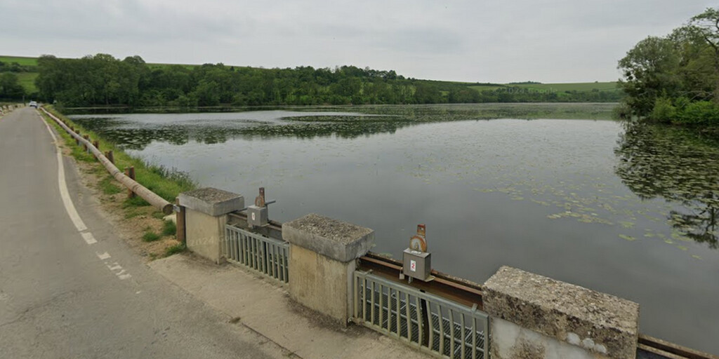
We drive via Lac de Bairon, a lake divided in two by a small road (D212), located just north of the village of Le Chesne. The old part of it used to belong to the monks of Chémery-sur-Bar.
We continue to Vouziers, where we cross the Aisne River. Those who appreciate beautiful portals can visit the Renaissance facade of the St. Maurille Church in Vouziers. This remarkable portal, created in the mid-16th century, remained detached from the rest of the church for over two centuries due to the Wars of Religion. It wasn't rebuilt until 1769.
The Vouziers Military Cemetery is the final resting place of pilot Roland Garros, who crossed the Mediterranean Sea in his small plane in 1913. He died in this area during the First World War. The Paris Grand Slam tennis tournament is named after him. His grave (and monument) is located in the "Cimetière militaire allemand de Vouziers" military cemetery. If you'd like to visit, the best place to park is in the town center (RP6) and walk to the cemetery.
We continue via Sainte Menehould, where Dom Pérignon, the first to effervescent Champagne wines, was born in 1638. He then traveled via Givry-en-Argonne to Vitry-le-François. This town was built to replace neighboring Vitry-en-Perthois, which was completely burned down by Quint's troops in 1544. For military and strategic reasons, the town center was built using only straight lines. In 1940, the town was almost completely destroyed by bombing and rebuilt on its original 16th-century layout.
The next town is Brienne, which is quite revered by Napoleon, as he studied there for five years at the military school. You can visit the small museum dedicated to him.
We continue through the Forêt d'Orient nature reserve. Located in the heart of the Grand Est region, in the Aube department, the Forêt d'Orient Regional Nature Park covers an area of 82,000 hectares, divided into several areas: the humid Champagne region, dotted with lakes, bocage landscapes, and forests; the chalky Champagne region with its rows of hills; the Aube Valley; and the three large lakes of the Forêt d'Orient. Together, these lakes represent the third-largest water reservoir in France; they attract thousands of birds, and thus many birdwatchers. Put on some good walking shoes and explore this pristine and preserved area to admire the local flora and fauna.
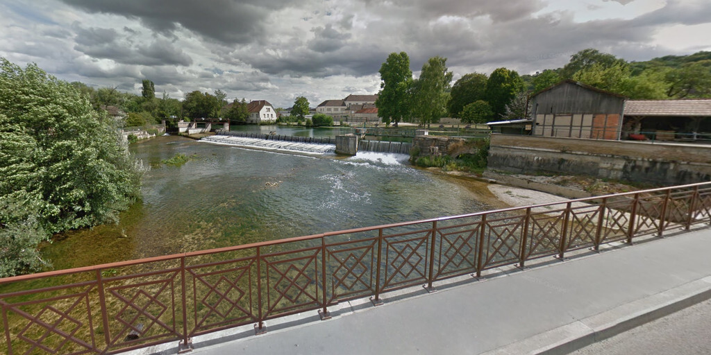
The original destination of this trip is Bar-du-Seine, a charming town on the still rather narrow Seine River. Bar-sur-Seine serves as a kind of gateway between Champagne and Burgundy. The beautiful old houses, some of which are half-timbered, reveal that life here was once quite prosperous. It's a pleasant town for a stroll and a drink and a bite to eat. There aren't many options for overnight stays in Bar-du-Seine, so we continued on to Mesnil-Saint-Père on the Lac d'Orient, where there are several hotels and campsites for overnight stays.
I rate this route 3*** stars because of the beautiful roads through the lovely French countryside and the nice pictures along the way.
 Links
Links  Usage
Usage Want to download this route?
You can download the route for free without MyRoute-app account. To do so, open the route and click 'save as'. Want to edit this route?
No problem, start by opening the route. Follow the tutorial and create your personal MyRoute-app account. After registration, your trial starts automatically.  Disclaimer
Use of this GPS route is at your own expense and risk. The route has been carefully composed and checked by a MyRoute-app accredited RouteXpert for use on TomTom, Garmin and MyRoute-app Navigation.
Changes may nevertheless have occurred due to changed circumstances, road diversions or seasonal closures. We therefore recommend checking each route before use.
Preferably use the route track in your navigation system. More information about the use of MyRoute-app can be found on the website under 'Community' or 'Academy'.

Grand Est
About this region
Grand Est (French: [ɡʁɑ̃t‿ɛst] (listen); Alsatian: Grossa Oschta; Moselle Franconian/Luxembourgish: Grouss Osten;
Rhine Franconian: Groß Oschte; German: Großer Osten [ˈɡʁoːsɐ ˈʔɔstn̩]; English: "Greater East") is an administrative region in Northeastern France. It superseded three former administrative regions, Alsace, Champagne-Ardenne and Lorraine, on 1 January 2016 under the provisional name of Alsace-Champagne-Ardenne-Lorraine (pronounced [alzas ʃɑ̃paɲ aʁdɛn lɔʁɛn]; ACAL or, less commonly, ALCA), as a result of territorial reform which had been passed by the French Parliament in 2014.The region sits astride three water basins (Seine, Meuse and Rhine), spanning an area of 57,433 km2 (22,175 sq mi), the fifth largest in France; it includes two mountain ranges (Vosges and Ardennes). It shares borders with Belgium, Luxembourg, Germany and Switzerland. As of 2017, it had a population of 5,549,586 inhabitants. The prefecture and largest city, by far, is Strasbourg.
The East of France has a rich and diverse culture, being situated at a crossroads between the Latin and Germanic worlds. This history is reflected in the variety of languages spoken there (Alsatian, Champenois, and Lorraine Franconian). Most of today's Grand Est region was considered "Eastern" as early as the 8th century, when it constituted the southern part of the Francian territory of Austrasia. The city of Reims (in Champagne), where Frankish king Clovis I had been baptized in 496 AD, would later play a prominent ceremonial role in French monarchical history as the traditional site of the coronation of the kings of France. The Champagne fairs played a significant role in the economy of medieval Europe as well. Alsace and Lorraine thrived in the sphere of influence of the Holy Roman Empire for most of the Middle Ages and Renaissance, and subject to competing claims by France and German over the centuries.
The region has distinctive traditions such as the celebration of Saint Nicholas Day, Christmas markets, or traditions involving the Easter hare in Alsace and Lorraine. Alsace-Moselle are furthermore subject to local law for historical reasons. With a long industrial history and strong agriculture and tourism (arts, gastronomy, sightseeing), the East of France is one of the top economic producing regions in the country.
Read more on Wikipedia
Rhine Franconian: Groß Oschte; German: Großer Osten [ˈɡʁoːsɐ ˈʔɔstn̩]; English: "Greater East") is an administrative region in Northeastern France. It superseded three former administrative regions, Alsace, Champagne-Ardenne and Lorraine, on 1 January 2016 under the provisional name of Alsace-Champagne-Ardenne-Lorraine (pronounced [alzas ʃɑ̃paɲ aʁdɛn lɔʁɛn]; ACAL or, less commonly, ALCA), as a result of territorial reform which had been passed by the French Parliament in 2014.The region sits astride three water basins (Seine, Meuse and Rhine), spanning an area of 57,433 km2 (22,175 sq mi), the fifth largest in France; it includes two mountain ranges (Vosges and Ardennes). It shares borders with Belgium, Luxembourg, Germany and Switzerland. As of 2017, it had a population of 5,549,586 inhabitants. The prefecture and largest city, by far, is Strasbourg.
The East of France has a rich and diverse culture, being situated at a crossroads between the Latin and Germanic worlds. This history is reflected in the variety of languages spoken there (Alsatian, Champenois, and Lorraine Franconian). Most of today's Grand Est region was considered "Eastern" as early as the 8th century, when it constituted the southern part of the Francian territory of Austrasia. The city of Reims (in Champagne), where Frankish king Clovis I had been baptized in 496 AD, would later play a prominent ceremonial role in French monarchical history as the traditional site of the coronation of the kings of France. The Champagne fairs played a significant role in the economy of medieval Europe as well. Alsace and Lorraine thrived in the sphere of influence of the Holy Roman Empire for most of the Middle Ages and Renaissance, and subject to competing claims by France and German over the centuries.
The region has distinctive traditions such as the celebration of Saint Nicholas Day, Christmas markets, or traditions involving the Easter hare in Alsace and Lorraine. Alsace-Moselle are furthermore subject to local law for historical reasons. With a long industrial history and strong agriculture and tourism (arts, gastronomy, sightseeing), the East of France is one of the top economic producing regions in the country.
View region
 Statistics
  84
84Amount of RX reviews (Grand Est)
 42696
42696Amount of visitors (Grand Est)
 14338
14338Amount of downloads (Grand Est)
 Route Collections in this region
 25 Magnificent trails in France
This MRA route collection contains 25 beautiful motorcycle routes in different parts of France, such as the Ardennes, the Alsace, Vercors, the Drôme, the Ardèche, Cote d'Azure, Gorges du Verdon, the Ariège, the Dordogne and Brittany.
The routes have been carefully created by Bert Loorbach, who is an enthusiastic motorcyclist himself. He lived in France for a year and a half, during which time he devoted himself to mapping the unknown and beautiful back roads of France especially for motorcyclists.
The routes are bundled in the Motortourgids France part 1 of Kosmos publishing house and now also available in MyRouteApp.
I have taken over the routes in MRA and sometimes adjusted them slightly to make them even more interesting for the motorcyclist.
View Route Collection
11 day trip from the Netherlands
8 countries in 11 days; The Netherlands, Germany, Austria, Italy, Switzerland, France, Luxembourg and Belgium. This route collections consists of 10 routes that I have driven with friends in the summer of 2019.
The start is in Geldermalsen Netherlands, the first 7 days you drive through the Netherlands, Germany, Austria, Italy, Switzerland, France and a piece of Luxembourg with overnight stays in hotels.
The last three days you stay in Barweiler (D) in the Eifel and you drive two beautiful tours through the Eifel, Luxembourg and parts of the Belgian Ardennes.
There is no highway in the routes, only beautiful provincial and country roads, many beautiful passes with beautiful panoramas.
Be sure to check whether the passes are open before you leave.
These are routes for experienced drivers.
View Route Collection