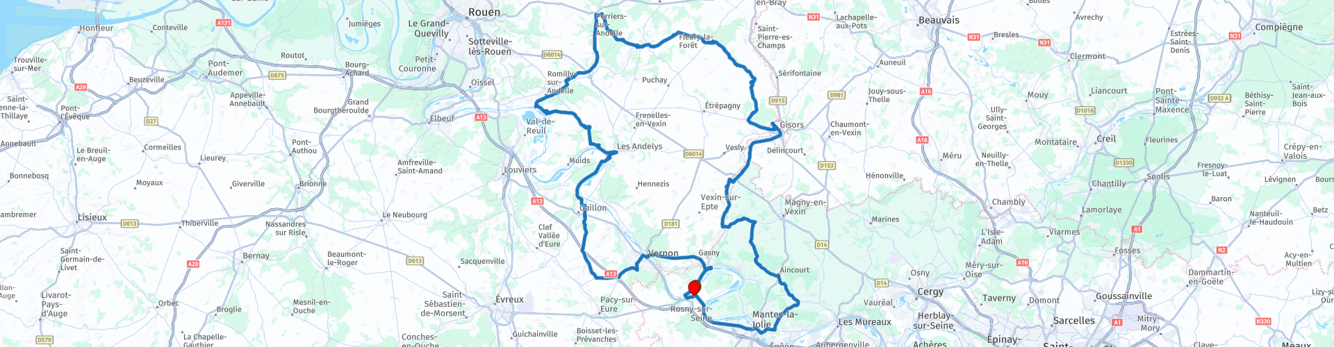
Roundtrip from Freneuse to Freneuse along castles and the Seine

This route was brought to you by:
RouteXpert Catherine De Groote RouteXpert
Last edit: 03-04-2022
 Route Summary
 Lovers of culture, history and architecture will find what they are looking for in Eure:
the house and gardens of Claude Monet, the castle of Gisors (castle), Château-Gaillard, Vascoeuil, center of art and history, to give some examples! Eure also has a lot to offer in terms of nature, with its flowery gardens, the beautiful forest of Lyons, and the valley of the Seine with the Boucle de Moisson.
When crossing this region you will notice that it is anything but flat here. The differences in height are limited, but it always goes up and down in a varied landscape with picturesque villages, beautiful castles and beautiful viewpoints. It is very quiet driving with little traffic so that you can fully enjoy the environment. This ride gets 5 stars.
 Share this route


Animation

Verdict


Duration
13h 55m

Mode of travel
Car or motorcycle

Distance
217.61 km

Countries

 RouteXpert Review
 A first short stop for a photo is at the Saint-Maclou Tower in Mantes-la-Jolie. The tower is classified as a historic monument. It is the still visible part of a church built at the beginning of the 11th century on the site of the former Hôtel Dieu. When William the Conqueror destroyed the entire city in 1087, this church did not escape this destruction. The construction dates of the current tower range from 1343 to the early 16th century. The tower of Saint-Maclou underwent numerous emergency restorations at the end of the 19th and the beginning of the 20th century. It came close to being completely destroyed in 1944 with the bombs of the Allies. It was the subject of new restoration campaigns in the second half of the 20th century, in particular a complete cleaning, restoring the original color.
A little further you come to the Collégiale Notre-Dame. This huge Gothic church, with the appearance of a cathedral, surprises with its size, its three carved portals and its two towers. A true jewel of Gothic architecture from the 12th century, the Collegiate Church is considered the little sister of Notre-Dame de Paris because of its resemblance and its proximity to the Seine. The building has a medieval nave. Its vaulted height is greater than that of the Basilica of Saint Denis. The towers culminate at 61 meters in height.
You leave the city and cross the Seine. The Seine is a 776-kilometre river that rises at an altitude of 446 m on the Langres plateau, north of Dijon. From there, the river flows northwest. The Seine passes through Troyes and then receives water from its tributary the Aube. The river then makes a slight bend to the southwest to the point where the Yonne flows into the Seine. The problem is that, on average, the Yonne carries more water than the Seine, so the Seine actually flows into the Yonne here. The river then flows to the northwest again. Just before she enters Paris, the Marne joins her. After Paris, the river continues to the northwest. The river begins to meander strongly here. The largest tributary, the Oise, flows into the Seine here. After Rouen, the Seine is navigable for large ships. The river meanders through to Le Havre, where it flows into the sea. The mouth of the Seine is an important nature reserve.
You leave the urban area and immediately enter a varied landscape. The road winds through both open areas and forests. Because of the height differences you have beautiful views.
The domain of Villarceaux consisted of a fortified house that had all the characteristics of the aristocratic stronghold of the old regime. The estate, which was part of the defense line of the kingdom of France, has been rebuilt in stone. For example, the lower castle has been reinforced. The estate grew in the 16th century and became an extensive agricultural estate, but also a place of pleasure: the canals became ornamental ponds, the multiple springs fed the water games.
Charles-Jean-Baptiste du Tillet, Marquis de la Bussière, cousin of the Marquis de Villarceaux, inherited the estate in the 18th century. He dismantled the feudal castle and built the upper castle and park overlooking the valley. Only a few elements of the lower castle remained. The mill buildings, the vegetable garden and the ponds were destroyed. The estate was classified as a historic monument at the end of the first half of the 20th century. In 2004, the park was awarded the 'Remarkable Garden' label.
A masterpiece of Renaissance architecture, the Château d'Ambleville is distinguished for its remarkable Italian-inspired terraced gardens. The castle and its gardens dominate the valley of the Aubette. The castle was built in the 16th century on the foundations of a feudal fortress built against the Anglo-Norman invasions. Listed as a historic monument since 1945, the Ambleville estate is also distinguished by its 'remarkable garden' label.
Not only the bedroom of Mis de Mornay, the grand staircase from the early 18th century, the leather room, the tapestry gallery and the Directoire dining room, but also the Italian-style terraced gardens, the open-air theatre, the ponds and water staircase, the monumental chess game, the three hundred year old lime trees... are worth a visit.
In Châteauneuf-sur-Epte we make a detour around the castle. The ruined castle was built in 1097 by William Rufus, King of England, to fortify the border along the River Epte. The castle stood on the border between the Duchy of Normandy and the Kingdom of France. In 1119 it was besieged by Louis VI of France. In the 12th century it was restored and fortified by Henry II of England. Other works were carried out in the 14th century. In 1437 it was captured by John Talbot, 1st Earl of Shrewsbury.
The castle's role diminished in the 16th century and it was dismantled by Mazarin in 1647. Converted into an agricultural center under the Ancien Régime, it included a motte with a stone keep, a lower courtyard connected to the motte and defended by a curtain wall flanked to the east and west by two fortified gates (14th century), a drawbridge and , in the lower forecourt, a medieval barn, a 17th-century corps de logis and a dovecote. The condition of the site deteriorated.
The ruins are private property. It has been listed as a monument by the French Ministry of Culture since 1926.
Then the ride goes to Gisors. It might be a good idea to take a coffee break in the brasserie Le Jean Bart. The brasserie is located on a corner and there is parking at the front as well as at the back. The reception is very hospitable.
In Gisors you can visit the impressive castle. This castle was considered one of the most important of the Counts of Normandy. In the 11th century, the English King William II commissioned a castle to be built on the hill near the town of Gisors. The castle was to defend the English territories of Normandy against the armies of the King of France. The first structure on this site dates from about 1095. A fortified keep had been built, surrounded by a high fortress wall. This fortress wall was in turn provided with several defense towers. At the beginning of the 13th century, a second keep was built and used as a prison. During the Hundred Years' War between France and England, the castle's defenses were further expanded. Despite the fortifications, the castle was conquered several times by the warring parties. At the beginning of the 17th century, the castle was partly dismantled, because it had lost its strategic value. Since 1862 it has been classified as a historical monument. From the castle you can enjoy a beautiful view of the surroundings.
A few hundred meters past the village of Fleury-la-Forêt you pass the castle of the same name. From the remarkable wrought iron gate you have a beautiful view of the imposing castle, built in flint and red brick in the 17th century. It is now a B&B.
In Lyons-la-Forêt you can enjoy half-timbered houses with beautifully colored plaster and pink bricks. You are welcome in charming tea houses, restaurants and antique shops. And in the middle of the village are the majestic covered market halls from the 18th century. A long street along the Lieure takes you to the church of Saint Denis (12th to 16th century).
This small village of 800 inhabitants was once a favorite destination for those seeking tranquility. Many artists in particular spent their summer holidays there and drew inspiration from it. Maurice Ravel composed there, Jean Renoir and Claude Chabrol shot film scenes. These film directors both used the village as the setting for a film adaptation of the novel Madame Bovary.
The atmosphere here is harmonious, typically Norman. The village of Lyons-la-Forêt is said to have been built around a fortified castle, built in the 11th century by William the Conqueror and completed by his youngest son, King Henry I. Its strategic location near the immense forest estate on the border of the kingdoms of England and France fueled the conflicts between the dukes of Normandy and the kings of France. Lyons-la-Forêt lost its castle to a fire.
It is an ideal opportunity to find a restaurant. Le Petit Lyons restaurant welcomes you in a warm and friendly environment at noon for lunch where you can come and taste a pizza and homemade dishes...
The Cistercian Abbey of Fontaine Guérard is located in the Andelle Valley, in the heart of wild nature and nestled at the foot of a miraculous spring with healing properties. The visitor will discover the cave cellar, the church and the vaulted choir, the chapter house, the study, the dormitory of the nuns with its beautiful framework in the hull of a tilted nave, and finally the cloister gardens.
The Amfreville locks, where the Andelle flows into the Seine, are a fine piece of technical ingenuity. The largest, 220 m and 17 m wide, can accommodate 15 ships up to 38 m long at the same time. You can get a good view of the fences from the bicycle and footbridge that go over it, but you can also see it well from the high Côte des 2 Amants. At Amfreville-les-Mont, take the D20 which goes quickly uphill. About 1.5 km further you come to a landscaped lookout on a slope high above the Seine bend, where the valley of the Andelle unfolds at your feet. There is a walking path from the car park which is a little further away.
If you would like to take a coffee break, this is easily possible in Les Andelys. In the charming brasserie 'Le Bar de l'Hôtel de Ville' you can enjoy a drink or a coffee and possibly a snack or small salad.
The town of Les Andelys, dominated by the imposing ruins of the famous Château-Gaillard, was born from the confluence of two districts: Petit-Andely and Grand-Andely, and is one of the most remarkable towns in the Seine valley. The city is located in the Gambon Valley, in the heart of one of the loops of the Seine. The slopes of the Seine at Les Andelys, 150 meters high, are part of the European network of protected Natura 2000 sites, mainly thanks to their special vegetation. The chalk cliffs, some of which are used by climbers, are among the highest in the Seine Valley. They form a picturesque landscape of white rock surrounded by very dense vegetation above the river.
Gaillard Castle is a military masterpiece from the Middle Ages. Between 1196 and 1198, Richard the Lionheart, King of England and Duke of Normandy, had Château Gaillard built. He did so on a chalk cliff to protect the duchy and the capital Rouen. It was a true masterpiece of military architecture, way ahead of its time. However, the building proved unable to withstand the attacks of Philip Augustus in 1204. In the Hundred Years War, the fort was recaptured by the English. In 1599, the French king Henri IV ordered the dismantling of the castle. In the following centuries, the remains of the castle fell into disrepair. In 1862, the ruins of the castle were declared a protected historic monument, which means that it can be visited to this day. Here you can enjoy a beautiful view of Les Andelys and the surrounding landscape.
The castle of Bizy consists of several buildings that were built at different times. Since the work started in 1740, successive owners have added part to the building over time. From the center of the courtyard, opposite the stables, you can admire the beautiful perspective of the fountains. Renowned for their 18th-century wood paneling and Gobelin tapestries from the Royal Houses series, the salons display memorabilia from the 1st Empire. The 19th-century apartments can only be visited with a guide.
The park of the Château de Bizy is also listed as a historic monument. The park is divided into two areas and is free to discover. Visiting the fountains allows you to see the details of the sculptures which together make a wonderful perspective. Thus, the seahorses and the one nicknamed 'Gribouille' can be approached up close. The water games today only evoke the former baroque splendor of the 18th century. The Promenade de Vénus is an old French garden. The river statue and the god Mars welcome you there. At the end of the promenade you will meet the goddess Venus, who quietly guards the top of the Avenue des Capucins that leads the Château de Bizy directly to the Seine.
On the other side of the Seine you can go to the castle of Tourelles. In 1196 King Philip II of France conquered the town and castle from the English. He then made it the basis for his future military operations. He built a bridge over the Seine. The castle is actually the bridgehead, built with the aim of protecting the bridge.
The castle of Tourelles was a simple square keep with four 20 meter high crenellated towers. The castle of Tourelles was almost never involved in military actions and was finally dismantled in 1650.
In the middle of the 18th century, a milling company moved into the castle and the surrounding area. It was then used as a silo and the spaces in the towers were used as offices. There was also a large structure built on top of the castle that extended to the river, which was used as a dock for loading the boats. During the Revolution, the milling business was stopped and moved out of the castle. It has been empty ever since.
During WWII, the castle of Tourelles was damaged by bombs, but later it was restored. At the moment the castle seems unusable and the interior cannot be visited. The garden is freely accessible.
The last castle on this ride is the castle of la Roche-Guyon. Strangely situated on the top of the hill, the fortified keep has towered over the Seine valley since the 12th century. The building received several important architectural additions in the 18th century. It is connected to the lower stronghold by a tunnel cut into the rock. During World War II, Rommel knew how strategically important the place would be. He established his headquarters in the part of the castle cut into the rock before being driven out by the Allies. Outside, it is possible to discover a very beautiful vegetable garden, which has been restored according to 18th century plans.
Enjoy the view of the Seine one last time and you will soon reach the end of this fascinating route.


 Links
Links  Usage
Usage Want to download this route?
You can download the route for free without MyRoute-app account. To do so, open the route and click 'save as'. Want to edit this route?
No problem, start by opening the route. Follow the tutorial and create your personal MyRoute-app account. After registration, your trial starts automatically.  Disclaimer
Use of this GPS route is at your own expense and risk. The route has been carefully composed and checked by a MyRoute-app accredited RouteXpert for use on TomTom, Garmin and MyRoute-app Navigation.
Changes may nevertheless have occurred due to changed circumstances, road diversions or seasonal closures. We therefore recommend checking each route before use.
Preferably use the route track in your navigation system. More information about the use of MyRoute-app can be found on the website under 'Community' or 'Academy'.

Hauts de France
About this region
Hauts-de-France (French pronunciation: [o də fʁɑ̃s] (listen); Picard: Heuts-d'Franche; lit. 'Heights of France') is the northernmost region of France, created by the territorial reform of French regions in 2014, from a merger of Nord-Pas-de-Calais and Picardy. Its prefecture is Lille. The new region came into existence on 1 January 2016, after regional elections in December 2015. The Conseil d'État approved Hauts-de-France as the name of the region on 28 September 2016, effective the following 30 September.With 6,009,976 inhabitants (as of 1 January 2015) and a population density of 189 inhabitants/km2, it is the third most populous region in France and the second most densely populated in metropolitan France after its southern neighbour Île-de-France. It is bordered by Belgium to the north.
Read more on Wikipedia
View region
 Statistics
  38
38Amount of RX reviews (Hauts de France)
 34110
34110Amount of visitors (Hauts de France)
 2652
2652Amount of downloads (Hauts de France)
 Route Collections in this region
 24 Magnificent trails in France
It is clear that France is one of the most beautiful and best touring countries. It offers an incredibly varied landscape with good roads and a pleasant climate. It is not for nothing that you see so many motorcyclists there. My previous collection of 25 routes in France (25 Magnificent routes in France) were based on the route descriptions from the Motortourgids France part 1 made by Bert Loorbach.
This collection of 24 routes comes from Motortourgids France part 2. In this collection, a difference has been made between approach routes and motorcycle tours in a certain area. The approach routes can also be used in combination with the routes from Motortourgids France part 1
The routes are sometimes slightly adjusted based on the tips that Bert Loorbach gives in his description, or because of another place to spend the night, or to reach the minimum length of 2 hours for the MRA Library. For each route, the review contains a more detailed description, including options to stay overnight or places of interest along the way, which are also indicated with a POI and if possible with a short description.
Two or more routes have been created for a number of areas, such as for Burgundy, Auvergne, The Alps, Tarn and Cévennes and Nord-Pas de Calais. These routes can be nicely combined in a multi-day trip.
View Route Collection
The 10 most downloaded routes in France from RouteXpert Catherine De Groote
Hello and welcome to this collection of the Top 10 MyRoute app downloaded routes in France.
A great new event will be announced soon, where all of these routes can be driven.
Download them all now and place them in a new "Top 10" folder so that you always have them at hand.
If you are going to drive one of these routes in the meantime, track them with the MRA Mobile App or with MRA Navigation. Take some photos (moments) along the way as they will come in handy.
Create a travelogue of your Top 10 driven routes and add the recorded track to it.
There will also be some great prizes on offer, so keep an eye on the MRA-RouteXperts page and your email.
View Route Collection