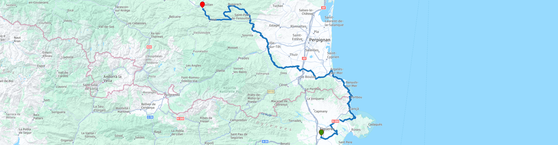
R06 - Figueres to Quillan

This route was brought to you by:
RouteXpert Arno van Lochem - Senior RX
Last edit: 08-04-2021
 Route Summary
 A little more to the north are the Pyrenees, where it is of course also beautiful to drive. In this route you will pass the part lying in the southwest of France. Erosion has left its mark here, resulting in beautifully carved gorges through which roads wind.
The route starts in Figueres. Soon you will reach the coast and drive north on beautiful coastal roads.
Once in France you drive a little more inland through beautiful surroundings.
The end of this route is at Hotel La Chaumière in Quillan.
This route is part of a tour through Catalonia, Andorra and the Pyrenees. This tour is divided into seven routes, of which this is the sixth part.
 Share this route


Animation

Verdict


Duration
7h 50m

Mode of travel
Car or motorcycle

Distance
243.35 km

Countries


 RouteXpert Review
 The Pyrenees are a true paradise for motorcyclists: Beautiful views and magnificent winding roads between imposing mountains. Given the beautiful environment in which the roads are really formidable and provide a lot of driving pleasure, I rate this route with 5 stars.
The route starts in Figueres at Hotel Restaurant Bon Retorn. From there you set course for the coast, which is reached after about 20 kilometers. The last stretch to the coast you drive on the GIP-6041, a fine stretch of asphalt with wonderful curves. Now and then the sea already appears in your view, it still promises something!
Immediately after arriving on the GI-612 you will see a sign with the text 'linia discontinua nomes indica eix de carretera', freely translated 'the dotted line only indicates the road axis'.
In the Netherlands, we are used to the fact that if it becomes more dangerous to overtake, the lines become longer and the distance between them shorter. So you don't have to expect that on this road, the stripes only indicate the axis of the road, no more and no less.
Just behind this sign you drive past a parking lot where it is worth stopping for a photo. You look out over the harbor of El Port de la Selva.
Driving on the GI-612 you will pass the turnoff to the d'Arinella lighthouse. This tower is included in the inventory of the architectural heritage of Catalonia.
The tower was built around 1900, initially a Maris oil lamp was used. In 1933, the oil lighting system was replaced by an acetylene type, which made it possible to emit flashes repeatedly. In March 1955 this system was also exchanged for an electric version.
In Llanca the Gi-612 turns into the N260. That is the name of the road in Spain. Arriving in France, this road has the name D914. A 30 kilometer long great stretch of asphalt with wonderful curves. The view may also be there. Fortunately, parking spaces have been built in various places so that you can stop for a while to enjoy those views. It is best to decide how often and where you want to stop to enjoy this beautiful area.
You pass the Cap Cerbère lighthouse, just crossed the French border. Seen from France, this is the last lighthouse before the Spanish border, this tower is also called the 'solar tower' because it is equipped with solar panels. This modern lighthouse was completed in 1982.
This construction was carried out to replace the old light of the port of Cerbère, removed in 1980. The site on the high cliffs of Cape Cerbère was chosen to exclude electricity from overhead wires so as not to disturb the landscape.
If you feel like visiting another lighthouse, it is possible at Port-Vendres. There you can find the Cap Béar lighthouse. The first tower to be built there dates from 1836. At a height of 23 meters, this tower had to indicate where the coastline was. Unfortunately, this first tower often had to do its job in the fog, which is of course not optimal. So a second tower was built, the light of which did its job at 80 meters above sea level. The tower emits 3 white flashes every 20 seconds.
The lighthouse, outbuildings and surrounding grounds are classified as a historic monument. It is currently owned by the state.
At Argelès-sur-Mer, the coast is deserted and you set course for the interior of France, or the Pyrenees! Via some small villages you soon drive on the D2, once on that road you can already see the mountains looming in the distance. A short time later the asphalt starts to swing nicely again and it is noticeable that it is going up here.
The D2 is not too wide a road, reason to take it easy, after all you never know if an oncoming car is coming. The nice and quiet touring also gives you the opportunity to enjoy the beautiful surroundings even more.
Shortly after lunch in Ille-Sur-Têt, you will pass a beautiful landscape known as 'Les Orgues d'Ille-sur-Têt', roughly translated as the organ pipes of Ille-sur-Têt. These are beautiful rock formations that have been carved out in the shape of organ pipes as a result of natural erosion. The beautiful landscape is the impressive result of millions of years of erosion. Due to the influences of the earth, the sun, wind and water, this impressive landscape has been carved out of soft sandstone. Organ pipes were recognized early in history in the eroded pieces of rock that were sometimes 12 meters high. Throughout the centuries these special rocks have been called the 'chimneys of the elves'. According to others, the landscape resembled the ruins of castles such as can be found elsewhere in the region. This special landscape has been cherished over the centuries and can therefore be visited by interested people to this day.
After the fuel stop you drive a bit on the great D7. Beautifully landscaped road through a magnificent piece of nature. To the left and right of you, the rock walls tower high above you. The road is sometimes so narrow that two cars cannot pass each other. In many places there are small coves where you can wait for your oncoming car.
You drive here through the Galamus gorge, which was created by a millions of years of erosion by the water of the river Agly. Thanks to the power of the water, several natural caves have also been carved into this gorge. Since the seventh century AD, these caves have been used as a refuge for hermits, who built huts here and stayed until their death. This is how the famous hermitage, better known as Ermitage Saint-Antoine de Galamus, was created, which is located about halfway up the Gorges de Galamus. Although this hermitage dates back to the eleventh century, hermits stayed there until 1950.
Partly due to the special location of this hermitage, scenes from various films have been shot here, including scenes from the film The Ninth Gate, by director Roman Polanski in 1998.
Until the year 1889, the Gorges de Galamus was virtually impassable for cars. A large-scale operation, in which pieces of rock were destroyed so that a road could be built, ensured that in 1890 a route between the towns of Cubières-sur-Cinoble and Saint-Paul-de-Fenouillet could be put into use.
The route continues on the D7, which turns into the D10 a little later. The first collets of this route also present themselves. For example, you come across the Col du Linas, the Col de Saint-Louis and the Col du Campérié.
You will pass Lapradelle between the two last mentioned colljes. As soon as you enter this village you will see the Chateau Puilarens on the top left of a mountain. For a long time, this chateau remained the southernmost fortified castle in France. Located at an altitude of almost 697 meters, this castle dominates the village of Puilaurens-Lapradelle, in the middle of a pine forest. The exact moment when the castle came under royal control is unknown, but the annexation appears to have been completed around 1250: in 1255 Saint Louis ordered the Sénéchal de Carcassonne to fortify the castle. While it was defending the border in Aragon, it was occupied in 1259 by the largest garrison on the entire border, commanded by Odon de Montreuil. Until the Treaty of the Pyrenees (1659), the castle suffered repeatedly from Spanish invasions. Badly defended and poorly maintained from the end of the 17th century, it was eventually left to the revolution.
Today the chateau can be visited. The last part, however, is a 15-minute walk on a rocky path.
Almost at the end of the route you will pass the gorge of Pierre-Lys. Again, a great piece of nature that you drive through. Next to the road you see a river flowing, de l'Aude. You can also see from the presence of this river that it took quite a few years to wear out this gorge.
The cliffs on both sides of the road reach impressive heights. The roadside guardrail offers little more than symbolic protection. Yet great to ride!
A little later you will reach the end of this route in Quillan at hotel La Chaumière. It is a hotel located in the center of the town, around it are several restaurants, so there is also some entertainment in the evenings.
Have fun driving this route!


 Links
Links  Usage
Usage Want to download this route?
You can download the route for free without MyRoute-app account. To do so, open the route and click 'save as'. Want to edit this route?
No problem, start by opening the route. Follow the tutorial and create your personal MyRoute-app account. After registration, your trial starts automatically.  Disclaimer
Use of this GPS route is at your own expense and risk. The route has been carefully composed and checked by a MyRoute-app accredited RouteXpert for use on TomTom, Garmin and MyRoute-app Navigation.
Changes may nevertheless have occurred due to changed circumstances, road diversions or seasonal closures. We therefore recommend checking each route before use.
Preferably use the route track in your navigation system. More information about the use of MyRoute-app can be found on the website under 'Community' or 'Academy'.

Occitanie
About this region
Occitanie (French pronunciation: [ɔksitani] (listen); Occitan: Occitània [utsiˈtanjɔ]; Catalan: Occitània [uksiˈtaniə]), Occitany or Occitania (), is the southernmost administrative region of metropolitan France excluding Corsica, created on 1 January 2016 from the former regions of Languedoc-Roussillon and Midi-Pyrénées. The Council of State approved Occitanie as the new name of the region on 28 September 2016, coming into effect on 30 September 2016.The modern administrative region is named after the larger cultural and historical region of Occitania, which corresponds with the southern third of France. The region Occitanie as it is today covers a territory similar to that ruled by the Counts of Toulouse in the 12th and 13th centuries. The banner of arms of the Counts of Toulouse, known colloquially as the Occitan cross, is used by the modern region and is also a popular cultural symbol. In 2015, Occitanie had a population of 5,839,867.
Read more on Wikipedia
View region
 Statistics
  78
78Amount of RX reviews (Occitanie)
 26991
26991Amount of visitors (Occitanie)
 3864
3864Amount of downloads (Occitanie)
 Route Collections in this region
 25 Magnificent trails in France
This MRA route collection contains 25 beautiful motorcycle routes in different parts of France, such as the Ardennes, the Alsace, Vercors, the Drôme, the Ardèche, Cote d'Azure, Gorges du Verdon, the Ariège, the Dordogne and Brittany.
The routes have been carefully created by Bert Loorbach, who is an enthusiastic motorcyclist himself. He lived in France for a year and a half, during which time he devoted himself to mapping the unknown and beautiful back roads of France especially for motorcyclists.
The routes are bundled in the Motortourgids France part 1 of Kosmos publishing house and now also available in MyRouteApp.
I have taken over the routes in MRA and sometimes adjusted them slightly to make them even more interesting for the motorcyclist.
View Route Collection
24 Magnificent trails in France
It is clear that France is one of the most beautiful and best touring countries. It offers an incredibly varied landscape with good roads and a pleasant climate. It is not for nothing that you see so many motorcyclists there. My previous collection of 25 routes in France (25 Magnificent routes in France) were based on the route descriptions from the Motortourgids France part 1 made by Bert Loorbach.
This collection of 24 routes comes from Motortourgids France part 2. In this collection, a difference has been made between approach routes and motorcycle tours in a certain area. The approach routes can also be used in combination with the routes from Motortourgids France part 1
The routes are sometimes slightly adjusted based on the tips that Bert Loorbach gives in his description, or because of another place to spend the night, or to reach the minimum length of 2 hours for the MRA Library. For each route, the review contains a more detailed description, including options to stay overnight or places of interest along the way, which are also indicated with a POI and if possible with a short description.
Two or more routes have been created for a number of areas, such as for Burgundy, Auvergne, The Alps, Tarn and Cévennes and Nord-Pas de Calais. These routes can be nicely combined in a multi-day trip.
View Route Collection