MTG2 15 French Alpes Bourg St Maurice Val d Isere Modane La Grave

This route was brought to you by:
RouteXpert René Plücken (MRA Master)
Last edit: 09-09-2025
 Route Summary
 This route comes from the French Motorcycle Tour Guide Part 2 and the original name is "The Alps Route Description 4 from Bourg St Maurice to the Col de Galibier".
In the French Motorcycle Tour Guide, Part 2, a distinction is made between approach routes and tours within a specific area. The approach routes can also be used in conjunction with the routes from the French Motorcycle Tour Guide, Part 1.
The routes have sometimes been slightly modified based on tips Bert Loorbach provides in his description, or because of a different overnight stay, or to meet the minimum two-hour time limit for the MRA Library. Each route review includes a more detailed description, including overnight options and points of interest along the way, which are also indicated with a point of interest and, if possible, a short description.
This route is without a doubt worth 5***** stars, the roads, surroundings and beautiful passes will stay in your mind for a long time and the next route connects to this and is also incredibly beautiful.
 Share this route


Animation

Verdict


Duration
6h 18m

Mode of travel
Car or motorcycle

Distance
175.78 km

Countries

 RouteXpert Review
 This route features many passes with stunning bends and also the necessary hairpin bends. We'll be going up and down mountains, so the steering is fantastic, with beautiful panoramas along the way. This route connects to the previous one, so we'll depart from Bourg St. Maurice.
We drive through the Vanoise National Park right along the border with Italy over beautiful winding passes with beautiful roads and some rugged mountain trails.
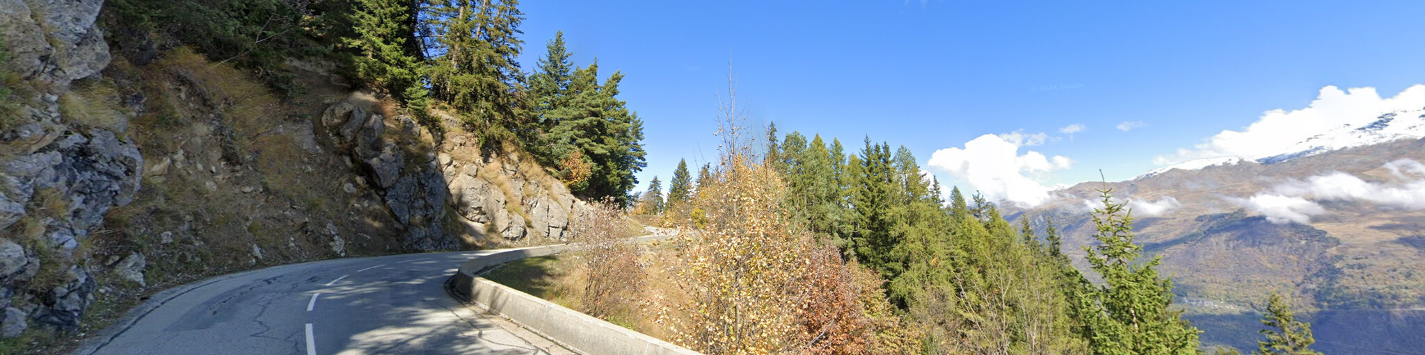
From Bourg-St. Maurice to Val-d'Isère, we drive on the D908, a well-paved two-lane road with lovely gentle curves, but also the occasional delightful hairpin bend. After about 19 km, we leave the D908 and take the narrow and very winding D87B to the dam at Lac du Chevril.
After the dam, we return to the D908. This section features numerous tunnels, some of which are partially open, offering beautiful views of the lake, the forests, and the mountains. Be careful in these tunnels, as the lighting is poor and cyclists are also present.
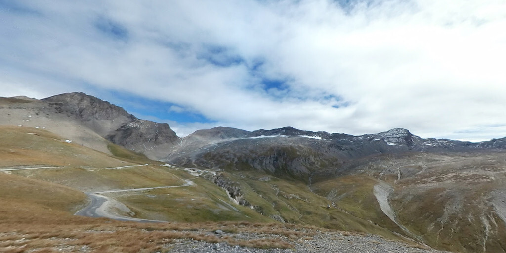
After passing through several tunnels and the Lac du Chevril, you arrive in Val d'Isère, a well-known ski resort and home to France's most famous 4x4 show (around mid-August). Next, a beautiful stretch of scenic road includes a real pass, the Col de L'Iseran, at 2,764 meters. At the top, you can stop for a drink and enjoy the truly magnificent view.
Then comes the Col de L'Iseran itself, where the Alps reveal their rugged side. Snow covers the area all summer, and the pass usually doesn't open until early July, so plan your trip accordingly. This magnificent pass takes you along narrow, winding roads through breathtaking scenery with stunning panoramas to Bonneval-sur-Arc. This charming village, situated at an impressive 1,885 meters, has made an effort to preserve its original charm. The rust-brown stone roofs are unspoiled by TV antennas and all sorts of wires.
Via Bessans, you'll briefly pass beneath the Vanoise National Park, as this beautiful area is also known. This national park was the first in France (1963), and its primary focus was on protecting the last ibex. In the year it was established, only 40 remained. Now, more than a thousand are roaming freely.
We drive via the Col de La Madeleine towards Modane. Be sure to stop at Parcobrance du Diable, the largest forest adventure park in Savoy (some call it a treetop adventure park). There are 230 workshop games for all levels, spread over 24 different circuits. It's located near the Redoute Marie-Thérèse (the barrier of the Esseillon forts), just above the Arc gorges and the Pont du Diable, a wooden bridge spanning an 80-meter-deep gorge, so it's definitely worth a stop.
From Modane to St. Michel-de-Maurienne, the route is a little less interesting, but there's no alternative. We take the D1006 (parallel to the A43/E70 motorway). In St. Michel-de-Maurienne, we take the D902 and cross the railway line, the Arc River, and the new motorway, before enjoying the festival of a thousand bends.
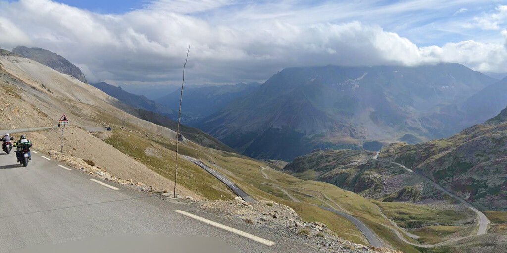
We reach Valloire via the Col du Télégraphe, where the road offers fewer bends, so we take a step back for the grand finale of this ride: the Col du Galíbier! This Tour de France highlight is also a highlight for motorized cornering enthusiasts, and the tires and brake discs don't have time to cool down. There's no time to enjoy the scenery; we'll do that at the top, so we definitely stop at the summit to enjoy the magnificent view from 2645 meters. It also almost marks the end of this fantastic ride, which finishes a little further on in La Grave, near the Col de Lautaret.
You can spend the night at one of the campsites or in one of the hotels in La Grave.
Another list of the Cols we rode;
At 2,770 m, the Col de l'Iseran, part of the departmental road D902, is the highest paved mountain pass in the Alps and Europe.
The Col de la Madeleine is a mountain pass (1993 m) in the French Alps. It is best known for hosting cycling stages in the Tour de France. The Col de la Madeleine has been included in the Tour de France 25 times. The first time was in 1969, and most recently in 2018.
Col du Télégraphe (1566m) is a mountain pass in the French Alps. The pass is best known for hosting cycling stages in the Tour de France.
The Col du Galibier is a mountain pass (2642m) in the French Alps. It connects Saint-Michel-de-Maurienne and Briançon via the Col du Télégraphe to the north and the Col du Lautaret to the south. The pass is closed in winter.
 Links
Links  Usage
Usage Want to download this route?
You can download the route for free without MyRoute-app account. To do so, open the route and click 'save as'. Want to edit this route?
No problem, start by opening the route. Follow the tutorial and create your personal MyRoute-app account. After registration, your trial starts automatically.  Disclaimer
Use of this GPS route is at your own expense and risk. The route has been carefully composed and checked by a MyRoute-app accredited RouteXpert for use on TomTom, Garmin and MyRoute-app Navigation.
Changes may nevertheless have occurred due to changed circumstances, road diversions or seasonal closures. We therefore recommend checking each route before use.
Preferably use the route track in your navigation system. More information about the use of MyRoute-app can be found on the website under 'Community' or 'Academy'.

Provence Alpes Cote d Azur
About this region
Provence-Alpes-Côte d'Azur (French pronunciation: [pʁɔvɑ̃s‿alp kot d‿azyʁ]; Occitan: Provença-Aups-Còsta d'Azur, [pɾuˈvɛnso̞ ˈawps ˈkɔsto̞ daˈzyɾ], or Provença-Alps-Còsta d'Azur, [pɾuˈvɛnso̞ ˈalps ˈkɔsto̞ daˈzyɾ]; commonly shortened to PACA; English: Provence-Alps-French Riviera; also known as Région Sud) is one of the eighteen administrative regions of France, the far southeastern on the mainland. Its prefecture and largest city is Marseille. The region is roughly coterminous with the former French province of Provence, with the addition of the following adjacent areas: the former papal territory of Avignon, known as Comtat Venaissin; the former Sardinian-Piedmontese County of Nice, whose coastline is known in English as the French Riviera and in French as the Côte d'Azur; and the southeastern part of the former French province of Dauphiné, in the French Alps. Previously known by the acronym PACA, the region adopted the name Région Sud as a commercial name or nickname in December 2017. 5,007,977 people live in the region according to the 2015 census.
It encompasses six departments in Southeastern France: Alpes-de-Haute-Provence, Alpes-Maritimes, Bouches-du-Rhône, Hautes-Alpes, Var and Vaucluse. It is bounded to the east by the France–Italy border, to the south by the Mediterranean Sea and by the Principality of Monaco, to the north by Auvergne-Rhône-Alpes and to the west by Occitanie, with the Rhône marking its westernmost border. The region logotype displays the coat of arms created in the 1990s and which combines the coats of arms of the old provinces making up Provence-Alpes-Côte d'Azur. The region's economy is the third largest in France, just behind Île-de-France and Auvergne-Rhône-Alpes. Its GDP in 2012 was €142.4 billion (US$183.1 billion) while its per capita GDP was €28,861 ($US 37,121).
Read more on Wikipedia
It encompasses six departments in Southeastern France: Alpes-de-Haute-Provence, Alpes-Maritimes, Bouches-du-Rhône, Hautes-Alpes, Var and Vaucluse. It is bounded to the east by the France–Italy border, to the south by the Mediterranean Sea and by the Principality of Monaco, to the north by Auvergne-Rhône-Alpes and to the west by Occitanie, with the Rhône marking its westernmost border. The region logotype displays the coat of arms created in the 1990s and which combines the coats of arms of the old provinces making up Provence-Alpes-Côte d'Azur. The region's economy is the third largest in France, just behind Île-de-France and Auvergne-Rhône-Alpes. Its GDP in 2012 was €142.4 billion (US$183.1 billion) while its per capita GDP was €28,861 ($US 37,121).
View region
 Statistics
  61
61Amount of RX reviews (Provence Alpes Cote d Azur)
 65114
65114Amount of visitors (Provence Alpes Cote d Azur)
 4491
4491Amount of downloads (Provence Alpes Cote d Azur)
 Route Collections in this region
 The 24 Most Beautiful Alpine Routes
The Alps, The Alps are a mountain range in Europe, stretching from the French Mediterranean coast in the southwest to the Pannonian Plain in the east. The area of the mountain range is more than 200,000 km².
In other words Passes and Mountain Roads!
Driving through the mountains is great! Especially over the mountain passes with hairpin bends and narrow winding roads. Every bend a different view where you can enjoy. There are many beautiful mountain passes in the Alps.
A selection that has also been incorporated into these routes:
The Stlevio Pass:
The Stelvio Pass, also known as Passo dello Stelvio, is mainly known for the stage in the Giro d'Italia. Due to the length and the difference in height, this pass is seen as one of the toughest tests in cycling. The Stelvio Pass reaches a maximum height of 2758 meters and is therefore one of the highest in the Alps. The pass connects the towns of Bormio and Prato Allo Stelvio. In winter the pass is closed due to heavy snowfall.
The Reschenpass:
The Reschenpass, also known as Passo di Resia, connects the Austrian state of Tyrol with the Italian province of South Tyrol. The pass reaches a maximum height of 1,504 meters and has been one of the most important north-south connections in the Alps in recent centuries. The pass was used long before Roman times. Along the way you will pass several highlights and historical relics. One of the highlights is the Reschensee. This lake was created after the construction of the dam and has completely submerged the village of Graun. The only thing that reminds of that is the clock tower in the middle of the lake.
Col du Galibier:
The French mountain pass Col du Galibier connects the towns of Saint-Michel-de-Maurienne and Briançon via the Col du Lautaret in the south and the Col du Télégraphe in the north. The mountain pass is part of the Tour de France and very much feared, due to the fact that it can only be reached via the other two mountain passes. The pass reaches a maximum height of 2646 meters. From there you can take a walk to the viewpoint at 2704 meters. You can admire the peaks of the Grand Galibier, Mont Blanc and La Meije here.
The Grossglockner High Alpine Road:
With a height of 3798 meters the Grossglockner is the highest mountain in Austria. To fully enjoy this impressive mountain, you can drive over the Grossglockner High Alpine Road and the accompanying pass. The route starts from Bruck am Grossglockner and ends in Heiligenblut. Of course you can drive in two directions. The pass reaches a maximum height of 2504 meters and is closed in winter due to heavy snowfall. Along the way you pass several stops with fun activities, information points, mountain huts and viewpoints. A visit to the Kaiser-Franz-Josefs-Höhe and Pasterzen Glacier is highly recommended.
The Col d'Izoard:
Just like the Col du Galibier, the Col d'Izoard is also part of a stage of the Tour de France. The mountain pass connects Briançon with the valley of the river Guil. The pass is partly located in the Regional Natural Park du Queyras and reaches a maximum height of 2360 meters. What is special about the Col d'Izoard is the barren and rocky landscape. Sometimes it feels like driving a car over the moon! Along the way you can stop at several points to enjoy the beautiful view.
The Bernina Pass:
The Bernina Express is one of the most famous rail trains in Switzerland and the Alps. The route is beautiful and partly included on the UNESCO World Heritage List. Parallel to the railway lies the Bernina pass, which connects the Veltlin valley with the Egandin valley. This beautiful Alpine road has a total length of 56 kilometers and reaches a maximum height of 2328 meters. Along the way you can enjoy views of the Morteratsch Glacier.
The Sella Pass:
The Sella Pass, also known as Passo di Sella, takes you over one of the most impressive mountain ranges in the Dolomites: the Sella massif. The pass connects Valle di Fassa with Val Gardena and reaches a maximum height of 2236 meters. At this height is also the border of the Italian provinces of Trentino and Bolzano. Along the way you can enjoy the view of this spectacular mountain world. Admire, for example, the three peaks of the Sasso Lungo massif, the Sella massif or the peaks of the Marmolada. You can also drive the Sella pass in combination with the Gardena pass, Pordoi pass and Campolongo pass.
The Grimsel Pass:
The Grimsel Pass connects Goms in Wallis with the Halis Valley in the Bernese Oberland. The pass reaches a maximum elevation of 2165 meters and is closed in winter due to snowfall. Over the centuries, the mountain pass has played an important role in trade between Switzerland and Italy. Now it is mainly the reservoirs that have an important function. These are used to generate electricity. The landscape you drive through is rugged, rocky and impressive. On top of the pass is a hotel and a restaurant with a special marmot park. The Dodensee (Totensee) is also located here. This lake owes its name to the many soldiers who died in the time of Napoleon.
The Gotthard Pass:
The Gotthard Pass, also known as Passo del San Gottardo and Saint Gotthard, connects the Swiss towns of Airolo and Andermatt. The mountain pass and associated tunnel are especially known among holidaymakers driving from Switzerland to Italy. But where the majority opt for the tunnel, it is precisely the pass that really completes the holiday. The Gotthard Pass has a length of about 26 kilometers and reaches a maximum height of 2106 meters. The route is beautiful and takes you along old villages and beautiful views.
The Silvretta High Alpine Road and Silvretta Pass:
The Paznaun Valley in Tyrol and the Montafon in Vorarlberg are connected by the Silvretta High Alpine Road. The route has a length of 22.3 kilometers and leads from Galtür to Partenen in 34 hairpin bends, via the 2032 meter high Bielerhöhe. The Silvrettasee is also located at this point, where you can enjoy a lovely walk. The pass is closed in winter due to snowfall.
The Simplon Pass:
Just like the Gotthard Pass, many holidaymakers also travel over the Simplon Pass every year. This mountain pass connects the Rhone Valley in the canton of Valais with the Valle d'Ossola in Piemonte. The pass is open all year round and reaches a maximum height of 2005 meters. Along the way you pass a number of buildings, including the well-known Simplon Hospiz from 1825. The hospiz is managed by the monks of St. Bernard. From the highest point on the pass, all kinds of hiking routes are possible and you will also come across a hotel where you can spend the night.
The Gerlos Pass:
The Gerlos Pass connects the Salzach Valley in the Salzburgerland with the Zillertal Valley in Tyrol. The pass is part of the Gerlos Alpenstraße and runs right through the Hohe Tauern National Park. Along the way you can enjoy beautiful views of the surroundings. The pass has a length of 12 kilometers and reaches a maximum height of 1531 meters. A ride over the Gerlos Pass can be ideally combined with a visit to the Krimmler Wasserfälle.
The Great St. Bernard Pass:
The Great St. Bernard Pass, better known as Col du Grand Saint Bernard, connects the Italian province of Valle d'Aosta with the Swiss canton of Valais. The pass is one of the highest in Switzerland and reaches a maximum height of 2469 meters. Like a number of other mountain passes in this list, the Great St. Bernard Pass has also been used as a connecting road for centuries. The pass is named after the St. Bernard dogs that used to help stranded travelers along with the monks. The pass is closed in winter.
The Timmelsjoch High Alpine Road:
The Timmelsjoch High Alpine Road connects the towns of Sölden in the Ötztal and Meran in South Tyrol. Tolls must be paid on the Hochgurgl - Moos route. Via a mountain road with about 60 hairpin bends you drive through a beautiful mountain world. With the Timmelsjoch Experience you can learn more about the history, the road and the environment via various stations. You can also visit the Top Mountain Crosspoint museum.
Col de l'Iseran:
With a maximum pass height of 2770 meters, the Col l'Iséran is one of the highest mountain passes in the Alps. The pass connects Bourg-Saint-Maurice with Bonneval-sur-Arc. Via a road full of hairpin bends you pass, among other things, Val-d'Isère and a side valley of the Maurienne that lies entirely in the National Park de la Vanoise. You can spot animals such as marmots and chamois and there is also a restaurant with a chapel on top of the pass.
The Gavia Pass:
The Gavia Pass (Italian Passo di Gavia) is a mountain pass in the Italian Alps, in the Lombardy region.
It is one of the highest pass roads in Europe. The road leads through the unspoilt Stelvio National Park. The road was built in the First World War to supply Italian soldiers who fought in the Italian-Austrian border area. The pass height is one of the most beautiful in the Alps. Here is the large Lago Bianco with, to the north, the mountain San Matteo (3684 meters). Lago Nero is slightly lower on the south side of the pass. Here the mountain group of the Adamello determines the view. There are many well-marked walks in the area. During the winter the pass is closed due to the heavy snowfall. The pass is often closed until May and June due to the large amount of snow.
Promoter has made a selection of the 24 Most Beautiful Alpine routes that they have set out in recent years.
The routes go through:
France
Austria
Switzerland
Italy
The most beautiful roads, the most beautiful views, the most beautiful viewpoints. The highest mountains, the fastest descents, hairpin bend after hairpin bend, you name it you can't get enough of it.
If you go on holiday in this region, take advantage of it, ALL routes in this collection have been checked and made equal for TomTom, Garmin and MyRoute-app Navigation by a MyRoute-app RouteXpert.
Have fun with this collection and while driving one of these routes. Enjoy all the beauty that the Alps and the Dolomites have to offer. Click on “View route” to read the review of the chosen route.
I would like to hear your findings about the route(s).
View Route Collection
25 Magnificent trails in France
This MRA route collection contains 25 beautiful motorcycle routes in different parts of France, such as the Ardennes, the Alsace, Vercors, the Drôme, the Ardèche, Cote d'Azure, Gorges du Verdon, the Ariège, the Dordogne and Brittany.
The routes have been carefully created by Bert Loorbach, who is an enthusiastic motorcyclist himself. He lived in France for a year and a half, during which time he devoted himself to mapping the unknown and beautiful back roads of France especially for motorcyclists.
The routes are bundled in the Motortourgids France part 1 of Kosmos publishing house and now also available in MyRouteApp.
I have taken over the routes in MRA and sometimes adjusted them slightly to make them even more interesting for the motorcyclist.
View Route Collection