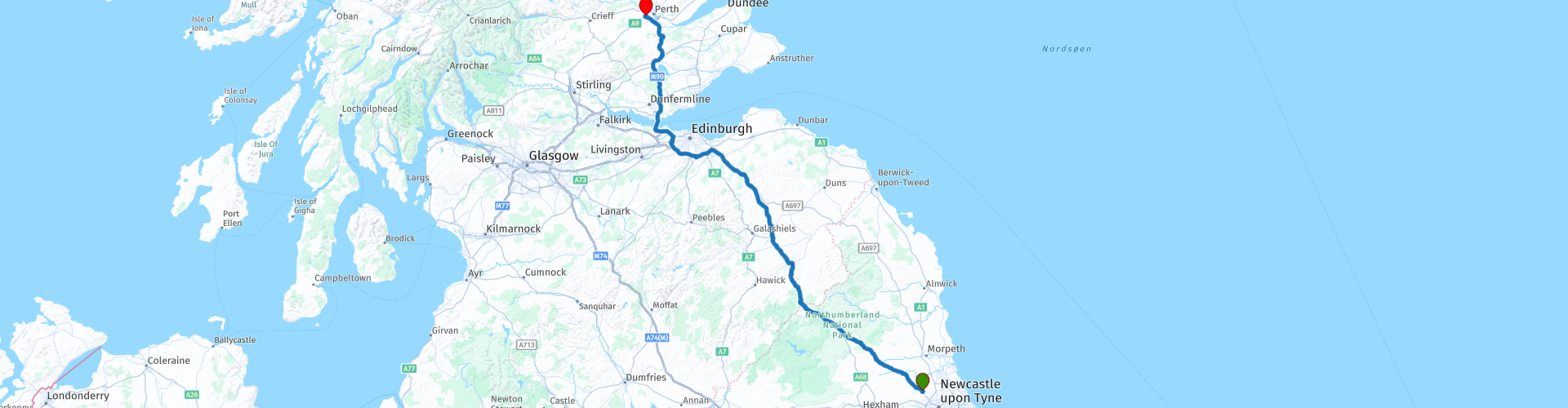
Newcastle to Perth

This route was brought to you by:
RouteXpert Nick Carthew - (MRA Master)
Last edit: 05-06-2025
 Route Summary
  Share this route


Animation

Verdict


Duration
5h 30m

Mode of travel
Car or motorcycle

Distance
236.69 km

Countries

 RouteXpert Review
 This is quite a straightforward route from the Premier Inn hotel at Newcastle airport to the Travelodge Hotel at Perth. The scenery changes from typical but beautiful English countryside to open moorland as you join the spectacular A68 through the Northumberland National Park, just before you reach the England/Scotland border you'll travel by Whitelee Moor, one of Britain's most important upland nature reserves. It's a site of European conservation importance due to its active blanket bog and heather heaths. The border between England and Scotland has a huge slab of rock with Scotland painted on it, it is almost obligatory to stop for a photo at the border.
10 miles on and you'll reach the town of Jedburgh where I have suggested a coffee stop at Border Meringues cafe. They serve delicious coffee and I can recommend the haggis toastie!
After another 10 miles you'll be at the Leaderfoot Viaduct a great place for a photo. The Leaderfoot Viaduct is sometimes known as the Drygrange Viaduct. This railway viaduct stretches over the River Tweed near Melrose and stands 126 feet from the floor of the river valley. It was opened in November 1863 for the Berwickshire Railway. The line closed to passenger traffic on 13 August 1948. Its historic listing was upgraded from Category B to A in 1986.
This route bypasses Edinburgh and crosses the Firth of Forth on the newly opened Queensferry Crossing bridge, this was still being built in May 2016 so we had to use the old Forth Road Bridge.
The Queensferry Crossing was completed in 2017 and is the longest triple tower cable-stayed bridge in the world, and the highest bridge in the United Kingdom. The completed towers stand at 207 metres, making it the UK's tallest bridge. Forth Road Bridge and Forth Rail Bridge to your right.
The M90 motorway is the fastest way to get to Perth but this route uses smaller, more enjoyable roads.
You'll pass by Loch Leven, the largest lowland loch in Scotland. The freshwater loch is an important site for waterfowl, with up to 35,000 birds present in the winter months. These birds migrate from a variety of places, such as Greenland, Iceland, Ireland, Siberia and northern and central Europe. Loch Leven is also important for breeding birds, and hosts one of the largest concentrations of breeding ducks of any non-coastal site in Europe.
There are seven islands on the loch, the largest being St Serf's Inch. Lochleven Castle, where Mary, Queen of Scots was imprisoned in 1567, lies on one of these islands, and it can be reached by a ferry in the summer months.
From the loch this route uses some beautiful small roads through the rolling hills of rich pasture and after about 40 minutes you'll be at the hotel on the outskirts of Perth.
The two hotels used for this route and the next route from Perth to Inverness have direct links below this review.


 Links
Links  Usage
Usage Want to download this route?
You can download the route for free without MyRoute-app account. To do so, open the route and click 'save as'. Want to edit this route?
No problem, start by opening the route. Follow the tutorial and create your personal MyRoute-app account. After registration, your trial starts automatically.  Disclaimer
Use of this GPS route is at your own expense and risk. The route has been carefully composed and checked by a MyRoute-app accredited RouteXpert for use on TomTom, Garmin and MyRoute-app Navigation.
Changes may nevertheless have occurred due to changed circumstances, road diversions or seasonal closures. We therefore recommend checking each route before use.
Preferably use the route track in your navigation system. More information about the use of MyRoute-app can be found on the website under 'Community' or 'Academy'.