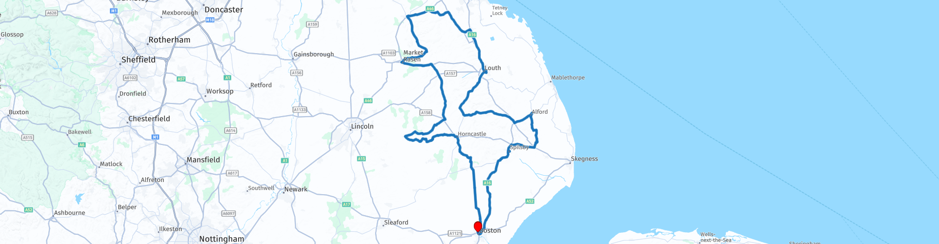
Round tour from Boston to Caistor Via Lincolnshire Wolds

This route was brought to you by:
RouteXpert Paul Taylor
Last edit: 19-09-2023
 Route Summary
 This route easily deserves 5***** stars because the roads are excellent, and the scenery and attractions are all very good.
 Share this route


Animation

Verdict


Duration
8h 14m

Mode of travel
Car or motorcycle

Distance
224.26 km

Countries

 RouteXpert Review
 Boston is the start location, but it isnt long before you are soon within the Wolds and your first stop at Horncastle, where the Saxon’s called the town Hyrnecastre, from whence its modern name arose, it is often referred to as the ‘Gateway to the Lincolnshire Wolds’, sitting right at the heart of the county. Surrounded by idyllic countryside, the town is ideally situated halfway between Lincoln and the coast . Although it was fortified it was not on any important Roman roads and it is believed that the river Bain was the principal route of access. It gets a mention in the Domesday Book, where it had 41 households, including 29 villagers, twelve smallholders, with 100 acres (0.4 km2) of meadow and two mills, all belonging to King William. It was given its crown market chartership in 1231 and was once the venue for the world’s largest horse fair that continued until the mid-20th century. There is the Grade II listed Old Court House in Louth Road that was built in 1865 and 116 other listed edifices in the town, including the three places of worship, St Mary's (Grade II*), Holy Trinity (Grade II) and the Congregational Church (Grade II). There are also several sections of the Roman walls (Grade I). In 1894 the Stanhope Memorial was raised in the centre of the Market Place in memory of Edward Stanhope MP it is a Grade II listed structure made of limestone, red sandstone and pink and grey streaked marble.
After leaving Horncastle you get to ride the famous Bardney and Bucknell bends (B1190) a motorcyclist heaven about 8 miles of great road and before you know it you are at Tupholme Abbey a Premonstratensian abbey close to the River Witham some 10.5 miles (16.9km) east of the city of Lincoln. The Witham Valley in Lincolnshire is notable for its high concentration of monasteries there were six on the east bank and three on the west all presumably drawn to the area by the usefulness of the River Witham for transport and by the wealth (in wool) that it transported. The abbey was largely destroyed by 1538, after being seized during Henry VIII's Dissolution of the Monasteries. Its name reflects the influence of Scandinavian cultures on Lincolnshire during the Danelaw during the 9th-11th centuries and it means basically an island where rams were raised. 'Tupp' is a word for male sheep first used in the north of Britain during the Middle Ages, with origins generally given as 'unknown', though it is conceivably related to the Swedish word 'tupp' meaning a male chicken (cock). As for the 'holme' in Tupholme, it comes from an old Norse word 'holmr', meaning an island and indicating that the abbey once stood on an island in a marsh, the surrounding lands having been wet before the fens were drained for farming.
From here it is into Bardney before heading back out on some great roads into the Wolds and onto Willingham woods. This is part of a large complex of pinewoods that are located east of Market Rasen. It is a well-known motorbike meeting place the woodlands is visited all year round but is especially popular during the summer months. With a picnic site, café, toilets and loads of free parking, it provides a diverse range of recreational opportunities including a range of walking trails of 2.2 miles (3.5km) and a fitting time for a scheduled refreshment stop.
Just after leaving Willingham woods, it is into Market Rasen whose place name is first attested in the Domesday Book of 1086, where it appears as Rase, Rasa and Resne. The name derives from the Old English ræsn meaning 'plank' and is thought to refer to a plank bridge. The river name 'Rase' is a back-formation. Famed for its racecourse it is another bustling market town in the Wolds where there has been a weekly market in the town since 1219, and it is still an integral part of the area today. The High Street here also boasts a great number of independent shops, many of which are long-standing, family-run businesses with such rich heritage.
Some 12 miles (19.3km) after leaving Market Rassen you arrive at Caistor whose name comes from the Anglo-Saxon ceaster ("Roman camp" or "town") and was given in the Domesday Book as Castre, nestled on a hillside and situated on the northern edge of the Lincolnshire Wolds and so is very popular with walkers with the Viking Way running through the town. This area was one of the most significant Roman settlements in the county; it is believed that it was once the site of 1st century military occupation and a 2nd century Roman fortress. Today, the market square lies at the heart of a conservation area that contains 56 listed buildings, making it one of Lincolnshire’s most important towns. Most of the Georgian houses here were built as Caistor became a major centre for the wool trade. The town used to host huge sheep markets, attracting farmers from across the country. In 1858, 60,000 sheep were sold here.
Leaving Caistor behind you, head out on the A46 and cut across onto the A18 then the A16 where there is a route option by taking the next left onto Station Road and follow for 0.65 miles (1.05km) to visit the home of the Lincolnshire Wolds Railway at Ludborough, the only full-sized steam railway in Lincolnshire. Once the main line railway linking the towns of Boston, Louth and Grimsby in Lincolnshire. First proposed on the 16 April 1845 and it opened in 1848. All intermediate stations, with most of the route, were closed to passengers in 1970. There is free onsite parking.
From here you stay on the A16 to Louth a town that originated in Saxon times either side of the River Lud where it is crossed by the ancient trackway along the east edge of the Wolds. The name derives from Hlud or Loud, referring to the fast-flowing river that powered up to 13 watermills. In the Domesday book of 1086, Louth had a population of about 600, as its importance grew as the trading centre between Wolds and Marsh, by 1300 the population had grown to 2,000 and there were two annual 8-day fairs. The abbey at Louth Park just east of the town was founded in 1139 its Cistercian Order had a reputation as sheep farmers and the income was devoted to building a large cruciform abbey church. Most of Louth prosperity was due to the long staple of sheep reared on the Wolds and grazed on the ‘rich fatting pastures’ of the Marsh. Louth has retained its medieval street plan and avoided the town centre changes that have spoilt many of England’s market towns. There is free motorbike parking within the town in the designated bike parking bays and lots of choice for some lunch.
Leaving Louth there is another route option by taking the next right down Halfpenny Road for 0.4 miles (0.65km) to visit Hubbard’s Hill a 40m deep, steep sided chalk valley, originally cut by torrents of glacial meltwater during the last ice age about 40,000 years ago. The ice had dammed up the Hallington Valley to create a lake which spilled over into the Welton Valley as a waterfall. As this was cut back, so Hubbard’s Hills was formed. Such was the volume of water that this process took two to three hundred years.
Heading away from Louth on the A153 there is another route option for a chance to visit the famous Cadwell Park Motor Racing Circuit established in 1934 and sited on former parkland across a steep-sided valley with dips and crests, the 2.19 miles (3.52km) long circuit features sharp changes in gradient, including one section called “The Mountain” where bikes can become airborne by up to several feet. It’s mix of challenging corners has led to its nickname as the Mini-Nürburgring and is well worth a visit.
After here we head towards Alford whose name was possibly derived from “Eauford” (The ford across the eau or stream) In the Doomsday Book the name is given as “Alforde” The name Auford is found on many old charters and was in use for a considerable period of time. The Alford eau became Wold Grift Drain when it was turned into a catchwater drain. It is believed that Anglian invaders established the town around 600 – 650 A.D on the dry gravel ridge on the edge of the marsh and nestled by the chalk hills. Now a beautiful market town right at the foot of the eastern fringes of the Wolds where you can enjoy the peaceful atmosphere, beautiful scenery and buildings including the five sailed windmill built in 1837, Alford Manor House which is reputedly the largest thatched manor house in the country, now a Grade II* Listed Building built in 1611 to a traditional H plan and St Wilfrid church which dominates the town, this was the second church to be built on this site as the first was constructed of wood, originally thought to have been built in 1350 it still retains traces of 16th-century glass within the stained-glass windows, a 17th-century tomb and six bells hanging in its bell tower cast in the early 20th century. There is also a scheduled stop here for refreshments at Cafe On The Cobbles or you might decide to choose another one of the many eateries within the vicinity.
Some 12.1 miles (19.5km) and you are in Spilsby, a small quaint and peaceful market town filled with history and charm, its name is thought to originate from Spillir the Dane who owned a ‘by’ or settlement on the site of modern day Spilsby. Records show that Spilsby has been an important market location, providing a weekly market for the buying and selling of local produce for well over 700 years. But it is most famously known for being the birthplace of the renowned Arctic explorer, Sir John Franklin born on 16 April 1786, who served under Admiral Nelson at the Battle of Trafalgar, dominating the marketplace is an impressive statue of him. There is also the Church of St James built around the beginning of the 14th century originally using traditional Spilsby sandstone of the area, before being covered in ancaster stone in 1879, with its 6 bells which date from 1744, it also houses the Franklin memorial’s. Then there is the impressive former sessions house and gaol, now a theatre so again well worth a visit.
Just out of Spilsby there is one final route option for you to visit Bolingbroke Castle 2.34 miles (3.77km) away by taking the next right and follow the road for 0.66 miles (1.06km) where you take a left to West Keal then the next right signposted for Old Bolingbroke follow for a further 0.61 miles (0.98km) where you take a right again and head up Keal hill for a further 0.92 miles (1.48km) with a final right then left just before arriving at the remains of Bolingbroke Castle on your left, this is a 13th century hexagonal castle, birthplace in 1367 of the future King Henry IV, with adjacent earthworks. Besieged and taken by Cromwell's Parliamentarians in 1643. It is now run and owned by English Heritage with free entry and limited free off-road parking.
From here it is a short 14.3 mile (23km) ride back to Boston to finish the tour.


 Links
Links  Usage
Usage Want to download this route?
You can download the route for free without MyRoute-app account. To do so, open the route and click 'save as'. Want to edit this route?
No problem, start by opening the route. Follow the tutorial and create your personal MyRoute-app account. After registration, your trial starts automatically.  Disclaimer
Use of this GPS route is at your own expense and risk. The route has been carefully composed and checked by a MyRoute-app accredited RouteXpert for use on TomTom, Garmin and MyRoute-app Navigation.
Changes may nevertheless have occurred due to changed circumstances, road diversions or seasonal closures. We therefore recommend checking each route before use.
Preferably use the route track in your navigation system. More information about the use of MyRoute-app can be found on the website under 'Community' or 'Academy'.

Yorkshire and the Humber
About this region
Yorkshire and the Humber is one of nine official regions of England at the first level of ITL for statistical purposes. The population in 2011 was 5,284,000 with its largest settlements being Leeds, Sheffield, Bradford, Hull, and York.
It is subdivided into East Riding of Yorkshire, North Yorkshire (excluding areas in Tees Valley of North East England), South Yorkshire, West Yorkshire, North Lincolnshire and North East Lincolnshire. The committees for the region ceased to exist after the 12 April 2010; regional ministers were not reappointed by the incoming Coalition Government with associated the Government Offices abolished in 2011.
Read more on Wikipedia
It is subdivided into East Riding of Yorkshire, North Yorkshire (excluding areas in Tees Valley of North East England), South Yorkshire, West Yorkshire, North Lincolnshire and North East Lincolnshire. The committees for the region ceased to exist after the 12 April 2010; regional ministers were not reappointed by the incoming Coalition Government with associated the Government Offices abolished in 2011.
View region
 Statistics
  24
24Amount of RX reviews (Yorkshire and the Humber)
 25414
25414Amount of visitors (Yorkshire and the Humber)
 2479
2479Amount of downloads (Yorkshire and the Humber)
 Route Collections in this region
 The Ultimate 10 Day (North) UK Tour
Starting from and returning to Harwich ferry port, this tour follows the east coast of England up to the Highlands of Scotland and returns via the Lake District. It visits 6 of the UK's national parks and explores 2 islands and visits 2 James Bond 007 film locations.
Daily highlights.
Day 1, Harwich to Wells Next the Sea:
Southwold lighthouse, Cromer Crab lunch and sleeping on a Dutch barge.
Day 2, Wells Next the Sea to Middlesbrough:
Royal Sandringham Estate, Humber Bridge, a lap of Oliver's Mount, North York Moors National Park, Whitby Abbey the inspiration for Dracula.
Day 3, Middlesbrough to Dundee:
Tees Transporter Bridge, Angel of the North, Bamburgh Castle, Holy Island of Lindisfarne.
Day 4, Dundee to Inverness:
Cairngorms National Park, Balmoral Castle, Whisky Distilleries.
Day 5, Inverness to Ullapool:
Exceptional Landscapes, Falls of Shin, Loch Drumbeg Viewpoint, Kylesku Bridge.
Day 6, Ullapool to Dornie:
Kinlochewe viewpoint, Applecross Pass, Isle of Skye.
Day 7, Dornie to Keswick:
Eilean Donan Castle (007), Glencoe Pass, Glen Etive (007), Loch Lomond and Trossachs National Park.
Day 8, Keswick to Kendal:
A tour of the Lake District National Park visiting 6 of the best passes including Wrynose Pass and Hardknott Pass and 7 of the great lakes including Ullswater and Windermere.
Day 9, Kendal to Matlock:
Yorkshire Dales National Park, Ribblehead Viaduct, Peak District National Park, Snake Pass, Matlock Bath (motorcycle Mecca).
Day 10, Matlock to Harwich:
Heckington Windmill, Moulton Windmill, Dutch Quarter in Colchester.
By starting from Harwich, this tour avoids the traffic congestion of the south east and London making it perfect for European visitors wanting to see some of the best landscapes and sights that the north of the UK has to offer.
The cost of the ferry from Hoek Van Holland to Harwich return for motorcycle and rider costs £139.00 (163.51 Euro) (in 2019) which includes a cabin on the outward leg.
Where possible, motorways have been avoided and scenic routes are used every day.
Enjoy.
View Route Collection
Top 10 Downloaded UK routes by RouteXpert Nick Carthew
Hello and welcome to this collection of the Top 10 MyRoute app downloaded routes in the UK.
There will be a great new event to be announced soon, where all these routes can be ridden.
Download them all now and place them in a new "Top 10" folder, so that you always have them at hand.
If you are going to drive one of these routes in the meantime, track them with the MRA Mobile App or with MRA Navigation. Take some photos (moments) along the way as these will come in handy.
Create a travelstory of your Top 10 driven routes and add the recorded track to it.
There will also be some great prizes on offer, so keep an eye on the MRA-RouteXperts page and your email.
View Route Collection