IRL Day 6 Ring of Beara and Dursey Island

This route was brought to you by:
RouteXpert René Plücken (MRA Master)
Last edit: 19-08-2025
 Route Summary
 The routes take you past the most beautiful towns, villages, sights and wonders of nature.
All routes include waypoints for hotels, restaurants and POIs. The population is very friendly and hospitable, in every village there are several pubs and restaurants where you can enjoy the Irish cuisine.
Several (historical) sights are included in the routes and we try to avoid highways.
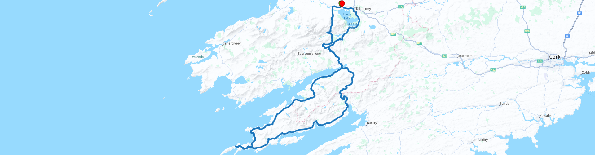
This itinerary covers the sixth day with a beautiful circular drive known as the “Ring of Beare” with visits to beautiful sights and a cable car crossing to Dursey Island.
This route has a 5 star rating.
 Share this route


Animation

Verdict


Duration
8h 32m

Mode of travel
Car or motorcycle

Distance
227.47 km

Countries

 RouteXpert Review
 From the hotel we drive to Gap of Dunloe, this is a very narrow winding mountain road through the beautiful green Irish landscape with rock formations and small streams and lakes.
The Ring of Beare is a beautiful route with many bends, hills, beautiful views and many historical sights. So there are also many points to stop. So prepare well and make a list of the points you want to visit and adjust the route with extra waypoints if necessary. You can find more information at the links in this review.
There is a possibility to visit the island of Dursey. The crossing is the Ballaghboy Cable Car. It is the only cable car in Ireland from the mainland to Dursey Island. The cable car runs daily, all year round and costs €10,- for a return trip.
It is a 10 minute crossing which offers a unique experience as the only cable car crossing open sea water in the whole of Europe. You may even see dolphins and whales. Dursey Island has no shops, pubs or restaurants so visitors are advised to take food and water with them if you plan to walk. It is a real walker’s paradise and popular for bird watching. There are thousands of seabirds to see including not only gannets but also Manx shearwaters, guillemots, razorbills and puffins.
In Castletownbere you can stop for lunch. Here you can take the ferry (free) to the island of Bere. A short winding road with beautiful views runs across the small island.
The route follows the coastline and there are several points along the way to stop for photos. From Glenngariff follow Kenmare Road (N71) through the Glenngariff Woods Nature Reserve, a beautiful narrow winding route through the woods, watch out for oncoming traffic, the road is very narrow.
At the end of the ring of Beare we reach Kenmare, a nice town with several pubs and restaurants to take a break. Via Molls Gap (the same route as on day 6) we drive back to our hotel in Killarney. Molls Gap is part of the Ring of Kerry, this is a beautiful winding route with many beautiful panoramas. At Ladies View definitely stop to take pictures. This is one of the most beautiful panoramas of Ireland.


 Links
Links  Usage
Usage Want to download this route?
You can download the route for free without MyRoute-app account. To do so, open the route and click 'save as'. Want to edit this route?
No problem, start by opening the route. Follow the tutorial and create your personal MyRoute-app account. After registration, your trial starts automatically.  Disclaimer
Use of this GPS route is at your own expense and risk. The route has been carefully composed and checked by a MyRoute-app accredited RouteXpert for use on TomTom, Garmin and MyRoute-app Navigation.
Changes may nevertheless have occurred due to changed circumstances, road diversions or seasonal closures. We therefore recommend checking each route before use.
Preferably use the route track in your navigation system. More information about the use of MyRoute-app can be found on the website under 'Community' or 'Academy'.