Day 05 of 12 Day Roadtrip Iceland Seydisfjoerdur Husavik

This route was brought to you by:
RouteXpert René Plücken (MRA Master)
Last edit: 12-02-2021
 Route Summary
 Rijden in IJsland is een geweldige ervaring, of je nu per auto of, zoals beschreven in deze review, per motor reist.
Deze routes zijn gemaakt op basis van informatie over IJsland die je kunt vinden op het Internet, met name van de Guide to Iceland, waar je en schat van informatie kan vinden om je goed voor te bereiden op je reis. Het materiaal op deze site is met zeer veel zorg samengesteld, de link is terug te vinden in de review van de eerste route uit deze reeks.
Je rijdt door landschappen die afwisselend en prachtig zijn, je ziet gletsjertongen, vulkanische bergen, geothermische gebieden met actieve geisers , lavavelden, kraters, bossen, watervallen en ongelooflijk ruige stukken kust.
De routes in het noorden maken deel uit van de 'Arctic Coast Way'.
De hoofdwegen zijn van goede kwaliteit maar je rijdt ook veel over gravel wegen, dus niet geschikt voor wegmotoren. Sommige van deze wegen zijn nog wel eens afgesloten worden vanwege het weer. Het is dus belangrijk dat je elke dag voordat je vertrekt de weersvoorspellingen en de situatie van de wegen controleert, deze informatie is te vinden op de website van “Icelandic Meteorological Office” en voor de wegen op de website van “The Icelandic Road and Coastal Administration”. De links staan in de review.
Vanwege het IJslandse klimaat kan deze reis alleen in de zomer worden gemaakt.
 Share this route


Animation

Verdict


Duration
4h 15m

Mode of travel
Car or motorcycle

Distance
300.72 km

Countries

 RouteXpert Review
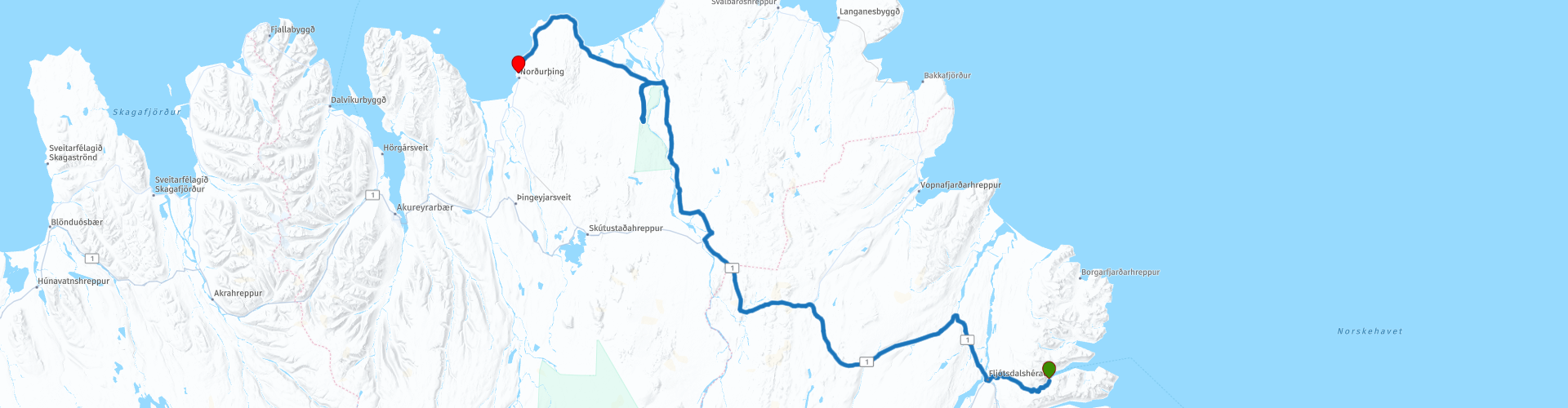
 We continue on to Egilsstaðir, a town with a number of hotels, cafés and restaurants. The town is located on Lake Lagarfljót (RP3). Those who are interested in cryptozoology should look for a minute over the still waters here; they are said to contain a frightening Wyrm creature that is somewhat similar to the Loch Ness monster.
However, the difference is that since 1345 records have been recorded from the Lagarfjót Wyrm, while Nessie was first seen in 1872.
Then you drive through the beautiful Icelandic to RP5 Jökulsárgljúfur, the northernmost part of the Vatnajökull National Park, geographically linked to the rest of the park by the glacier river Jökulsá á Fjöllum. The source of the river is in Vatnajökull glacier, near the subglacial volcano Bárdarbunga.
This gorge is 25 km long, 500 m wide and in many places 100-120 m deep, making it one of the deepest and most breathtaking gorges in Iceland. Jökulsárgljúfur is also known for its waterfalls: Selfoss, Dettifoss, Hafragilsfoss and Réttarfoss.
The park's visitor center is located in Ásbyrgi (RP5). There are also camp sites if you want to spend the night.
Ásbyrgi can be visited at any time of the year, although services may be limited in the winter. Dettifoss and Vesturdalur are located at higher altitudes and are therefore subject to snow cover and road conditions.
The next stop is Hljóðaklettar (RP6) in the gorge Jökulsárgljúfur is a distinctive cluster of columnar rock formations standing at the entrance to Vesturdalur, along the river Jökulsá á Fjöllum. The columns are at all angles and it can be an entertaining exercise for the imagination to interpret their patterns in as many different ways as possible.
We drive further through the beautiful Icelandic landscape to our final destination Húsavík.
I rate this route with 4 stars because of the beautiful Icelandic nature and the nature park.


 Links
Links  Usage
Usage Want to download this route?
You can download the route for free without MyRoute-app account. To do so, open the route and click 'save as'. Want to edit this route?
No problem, start by opening the route. Follow the tutorial and create your personal MyRoute-app account. After registration, your trial starts automatically.  Disclaimer
Use of this GPS route is at your own expense and risk. The route has been carefully composed and checked by a MyRoute-app accredited RouteXpert for use on TomTom, Garmin and MyRoute-app Navigation.
Changes may nevertheless have occurred due to changed circumstances, road diversions or seasonal closures. We therefore recommend checking each route before use.
Preferably use the route track in your navigation system. More information about the use of MyRoute-app can be found on the website under 'Community' or 'Academy'.