
Circumnavigation of Jersey from St Helier

This route was brought to you by:
RouteXpert Nick Carthew - (MRA Master)
Last edit: 23-12-2024
 Route Summary
  Share this route


Animation

Verdict


Duration
3h 43m

Mode of travel
Car or motorcycle

Distance
76.44 km

Countries

 RouteXpert Review
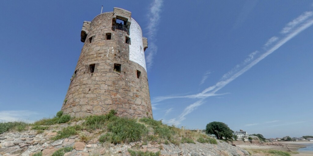
 The first historical landmark to catch the eye is Beaumont Tower, one of the Jersey round towers or Conway Towers. The British built 22 Conway towers and 8 Martello towers in the late18th century and early19th century, only 24 remain. Although frequently called Martello towers, the round Conway towers are taller, and predate the Martello towers. The Jersey towers are mostly built with local granite rather than brick, have a slighter batter (taper), and most importantly, originally did not have a cannon on the top platform. Originally constructed to defend the island against 18th-century French invasions. These robust granite structures stand as a testament to Jersey’s strategic importance. Interspersed along the coastline are Martello towers, designed during the Napoleonic Wars to deter enemy ships. These circular fortifications, with their thick walls and commanding views, offer a glimpse into Jersey’s martial history.
A short distance on and you can see Saint Aubin's Fort.
The fort stands on a tidal island, one third of a mile offshore, and was finished in the 1540s. At that time St Aubin was the primary port on Jersey and the fort controlled the entrance. A causeway extends from the road in front of the Royal Channel Islands Yacht Club to the fort, and can be reached on foot at low tide. The fort is closed to the public, but is still a great place to visit if you have time and the tide is in your favour.
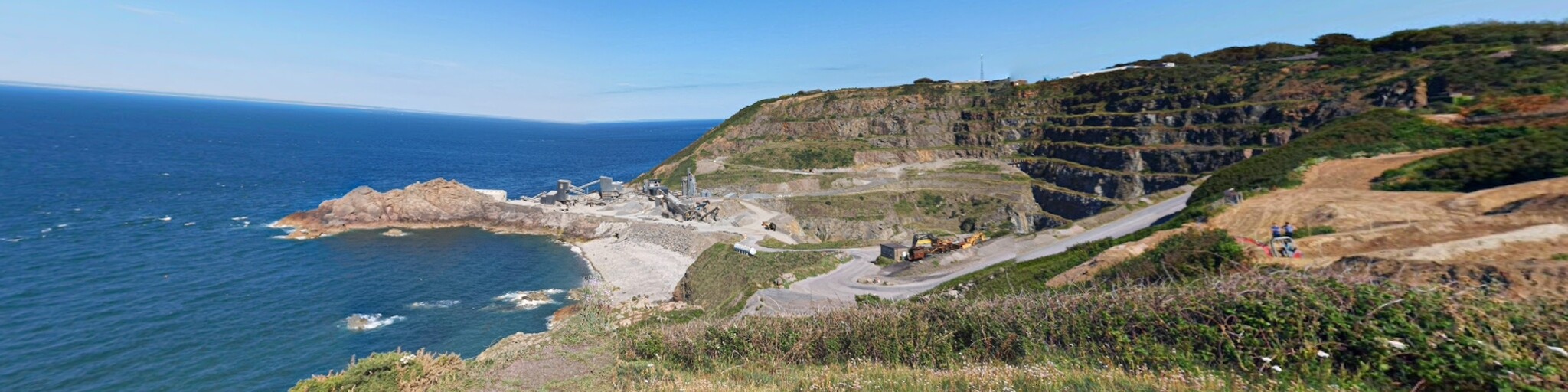
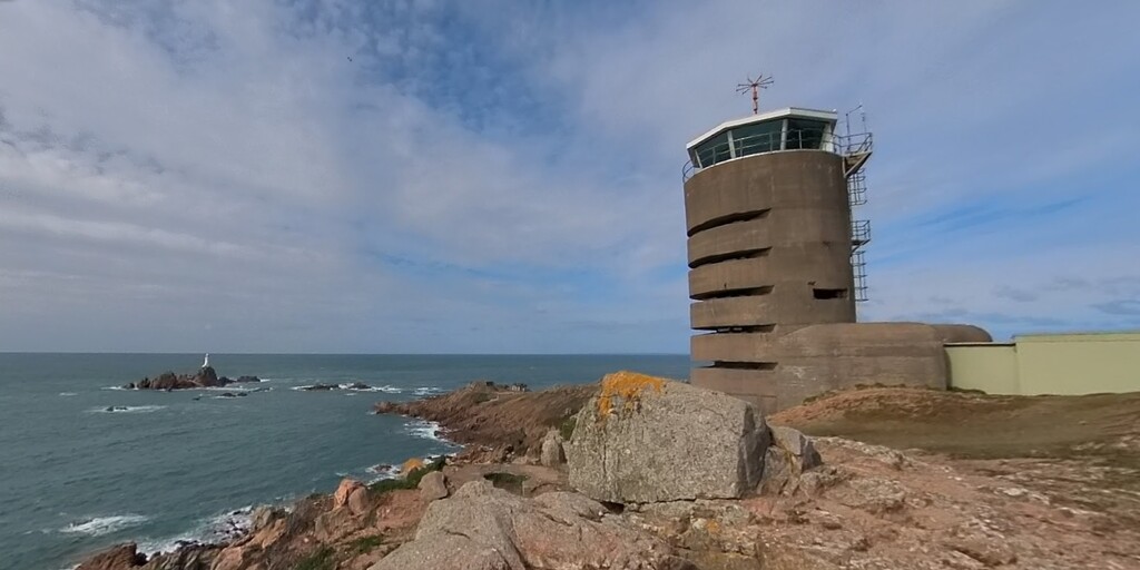
Continuing to Noirmont Point, you’ll encounter the imposing German fortifications built during the island’s occupation in World War II. Among these is the sinister looking naval range-finding tower, or Marine Peilstand und Meßstellung, Their names were abbreviated to MP and this one is known as MP1, a total of 3 that were built on the island. This cylindrical concrete structure was used to coordinate artillery fire against Allied forces. Exploring the site, you’ll find gun emplacements and bunkers that evoke the grim reality of Jersey’s wartime experience. The panoramic views from Noirmont Point also showcase the island’s beautiful rugged coastline.
You'll pass another Conway Tower at St Brelades on the way to the far south-west corner of the island. This area again was heavily fortified by the Nazis and the second of the naval range-finding towers MP2 can be seen along with La Corbière Lighthouse.
Heading north now and La Rocco Tower is a prominent feature of St Ouen’s Bay. It was built between 1796 and 1801 and derives its name from La Rocque Ho or Rocque Hou, meaning rocky islet. La Rocco was the 23rd and last coastal tower in Jersey to be built following the Conway design and was also the largest and most heavily armed of the whole series.
More towers are visible as you travel further north including Kempt Tower, originally a Martello tower dating from 1864 which has now been converted into luxurious holiday accommodation.
Next is the Channel Islands Military Museum, located in a restored German bunker, the museum provides an immersive look at Jersey’s occupation during World War II. The exhibits include weapons, uniforms, and personal stories from the era, bringing history to life. Standing within the concrete walls of the bunker, one can almost hear echoes of the past.
Sitting alongside the museum is Lewis’s Tower another Martello tower converted into holiday accommodation.
Etacquerel at the north end of St Ouen’s Bay was also heavily fortified by the Nazis during WW2. You'll see on the right a type 670 gun bunker made from concrete with a tunnel system behind and a larger concrete bunker now used as a seafood store that occupies the most prominent seaward point.
Up to the north-west corner now where you can see Grosnez Castle. The remains of this 14th-century castle on the clifftop consist of a lonesome arched gateway, some walls and the remnants of a moat. The coastal views from here are spectacular, and there are extensive German wartime fortifications a short distance to the southwest including the third range finding tower MP3. The windswept site offers dramatic views of the surrounding coastline and neighbouring islands. Nearby, Plemont Bay beckons with its secluded sandy beach and rocky caves. It’s an idyllic spot to pause and enjoy the sound of waves crashing against the shore.
The next stop is Grève de Lecq, a charming bay with golden sands and a welcoming café. Here, a cup of coffee and perhaps a slice of homemade cake provide the perfect respite. The bay’s sheltered location and scenic beauty make it a favourite among locals and visitors alike. The German Forces deployed a lot of armaments and bunkers in the area. In the middle of the bay a Conway Tower dominates the view, this Napoleonic era tower was also modified by the Germans to include a secure bunker at the base, and a roof-mounted machine gun.
Continuing the journey, the route winds toward Sorel Point, the northernmost tip of Jersey. The rugged cliffs and sweeping views from this vantage point are breath-taking. Next, Bonne Nuit Bay offers a tranquil harbour setting, and nearby Fort Leicester, a 19th-century military outpost, adds another layer of historical intrigue. The fort, nestled on the hillside, provides commanding views of the bay and surrounding area.
As the ride continues eastward, Verclut Point offers another striking coastal panorama. Passing through picturesque villages, you’ll eventually reach Mont Orgueil Castle in Gorey. This majestic medieval fortress has stood sentinel over Jersey’s eastern shores for over 800 years. Exploring its towers and battlements reveals a labyrinth of history, from medieval times to the English Civil War.
Heading south, look out to sea to catch a glimpse of Seymour Tower, a two-story granite structure built on a reef to defend against French attacks in the 18th century. Further along the coast, a stop at Le Hocq Tower allows you to venture inside this 18th-century Martello tower. Its interior reveals the ingenuity of historical fortifications, and the views from the top are worth the climb.
The journey next leads to Mount Bingham, where hidden German tunnels delve deep into the hillside. Constructed during World War II by forced laborers, these tunnels served as storage and defence hubs. Walking through their dimly lit corridors, it’s impossible not to feel the weight of history. Interpretive displays detail the tunnels’ construction and the hardships endured by those who built them.
The final leg of the journey returns to St. Helier, where the Maritime Museum provides a fitting conclusion. This interactive museum celebrates Jersey’s seafaring heritage, with exhibits ranging from ship models to tales of daring sea rescues. Engaging displays allow visitors to experience the island’s maritime traditions first hand.
Returning to The Kiosk in St. Aubin’s Bay, the circumnavigation ends where it began. The journey around Jersey has not only showcased its stunning landscapes and rich history but also provided a deeper appreciation for the island’s resilience and charm. Over a final drink, there’s time to reflect on the day’s journey and the enduring allure of this remarkable island.
 Links
Links  Usage
Usage Want to download this route?
You can download the route for free without MyRoute-app account. To do so, open the route and click 'save as'. Want to edit this route?
No problem, start by opening the route. Follow the tutorial and create your personal MyRoute-app account. After registration, your trial starts automatically.  Disclaimer
Use of this GPS route is at your own expense and risk. The route has been carefully composed and checked by a MyRoute-app accredited RouteXpert for use on TomTom, Garmin and MyRoute-app Navigation.
Changes may nevertheless have occurred due to changed circumstances, road diversions or seasonal closures. We therefore recommend checking each route before use.
Preferably use the route track in your navigation system. More information about the use of MyRoute-app can be found on the website under 'Community' or 'Academy'.

Channel Islands
About this region
The Channel Islands are an archipelago in the English Channel, off the French coast of Normandy. They are divided into two Crown Dependencies: the Bailiwick of Jersey, which is the largest of the islands; and the Bailiwick of Guernsey, consisting of Guernsey, Alderney, Sark, Herm and some smaller islands. Historically, they are the remnants of the Duchy of Normandy. Although they are not part of the United Kingdom, the UK is responsible for the defence and international relations of the islands as it is for the other Crown Dependency, the Isle of Man, and the British Overseas Territories. The Crown Dependencies are neither members of the Commonwealth of Nations, nor part of the European Union. They have a total population of about 171,916, and the bailiwicks' capitals, Saint Helier and Saint Peter Port, have populations of 33,500 and 18,207 respectively.
"Channel Islands" is a geographical term, not a political unit. The two bailiwicks have been administered separately since the late 13th century. Each has its own independent laws, elections, and representative bodies (although in modern times, politicians from the islands' legislatures are in regular contact). Any institution common to both is the exception rather than the rule.
The Bailiwick of Guernsey is divided into three jurisdictions – Guernsey, Alderney and Sark – each with its own legislature. Although there are a few pan-island institutions (such as the Channel Islands Brussels Office, the Director of Civil Aviation and the Channel Islands Financial Ombudsman, which are actually joint ventures between the bailiwicks), these tend to be established structurally as equal projects between Guernsey and Jersey. Otherwise, entities whose names imply membership of both Guernsey and Jersey might in fact be from one bailiwick only. For instance, The International Stock Exchange is in Saint Peter Port and therefore is in Guernsey.
The term "Channel Islands" began to be used around 1830, possibly first by the Royal Navy as a collective name for the islands.: 158 The term refers only to the archipelago to the west of the Cotentin Peninsula. Other populated islands located in the English Channel, and close to the coast of Britain, such as the Isle of Wight, Hayling Island and Portsea Island, are not regarded as "Channel Islands".
Read more on Wikipedia
"Channel Islands" is a geographical term, not a political unit. The two bailiwicks have been administered separately since the late 13th century. Each has its own independent laws, elections, and representative bodies (although in modern times, politicians from the islands' legislatures are in regular contact). Any institution common to both is the exception rather than the rule.
The Bailiwick of Guernsey is divided into three jurisdictions – Guernsey, Alderney and Sark – each with its own legislature. Although there are a few pan-island institutions (such as the Channel Islands Brussels Office, the Director of Civil Aviation and the Channel Islands Financial Ombudsman, which are actually joint ventures between the bailiwicks), these tend to be established structurally as equal projects between Guernsey and Jersey. Otherwise, entities whose names imply membership of both Guernsey and Jersey might in fact be from one bailiwick only. For instance, The International Stock Exchange is in Saint Peter Port and therefore is in Guernsey.
The term "Channel Islands" began to be used around 1830, possibly first by the Royal Navy as a collective name for the islands.: 158 The term refers only to the archipelago to the west of the Cotentin Peninsula. Other populated islands located in the English Channel, and close to the coast of Britain, such as the Isle of Wight, Hayling Island and Portsea Island, are not regarded as "Channel Islands".
View region
 Statistics
  1
1Amount of RX reviews (Channel Islands)
 2201
2201Amount of visitors (Channel Islands)
 4
4Amount of downloads (Channel Islands)